
Casa View Elementary/Casa View Park — 1954-1974
by Paula Bosse
 Casa View Elementary and next-door park, 1954 (click for larger image)
by Paula Bosse
I wrote about Casa Linda Park not long ago, so today … Casa View Park (and its neighbor, Casa View Elementary School).
After World War II, there was a severe housing shortage in Dallas, and developers began looking to areas which offered new land to build on and were ripe for annexation. One such area — east of White Rock Lake and beyond the city limits — was eyed as a prime site for a new residential neighborhood: it didn’t take long for the area now known as Casa View to pop up.
One of Casa View’s neighborhoods was Casa View Heights (which, roughly, is bounded by Garland Road, Centerville Road, Shiloh Road, and … maybe Barnes Bridge? — see ad below) — it was a development spearheaded by Carl Brown, whose nearby Casa Linda development had been a big hit. The land this addition was built on was annexed by the City of Dallas in 1949. In mid-1950, it was announced that “ten acres of pasture land north of Centerville Road in the Casa View area” had been purchased by the Dallas School Board, a tract which “some day may be the site of a school […] though the school building program has no project scheduled for the area” (“Sizable Land Plots,” Dallas Morning News, July 16, 1950).
About half that parcel of land became Casa View Park sometime in 1950; the other half became the campus of Casa View Elementary School. The school (designed by premier Dallas architect Mark Lemmon) began construction in 1952 and was ready for use by the opening of the new school year in 1953 (enrollment on the first day was an impressive 870 students).
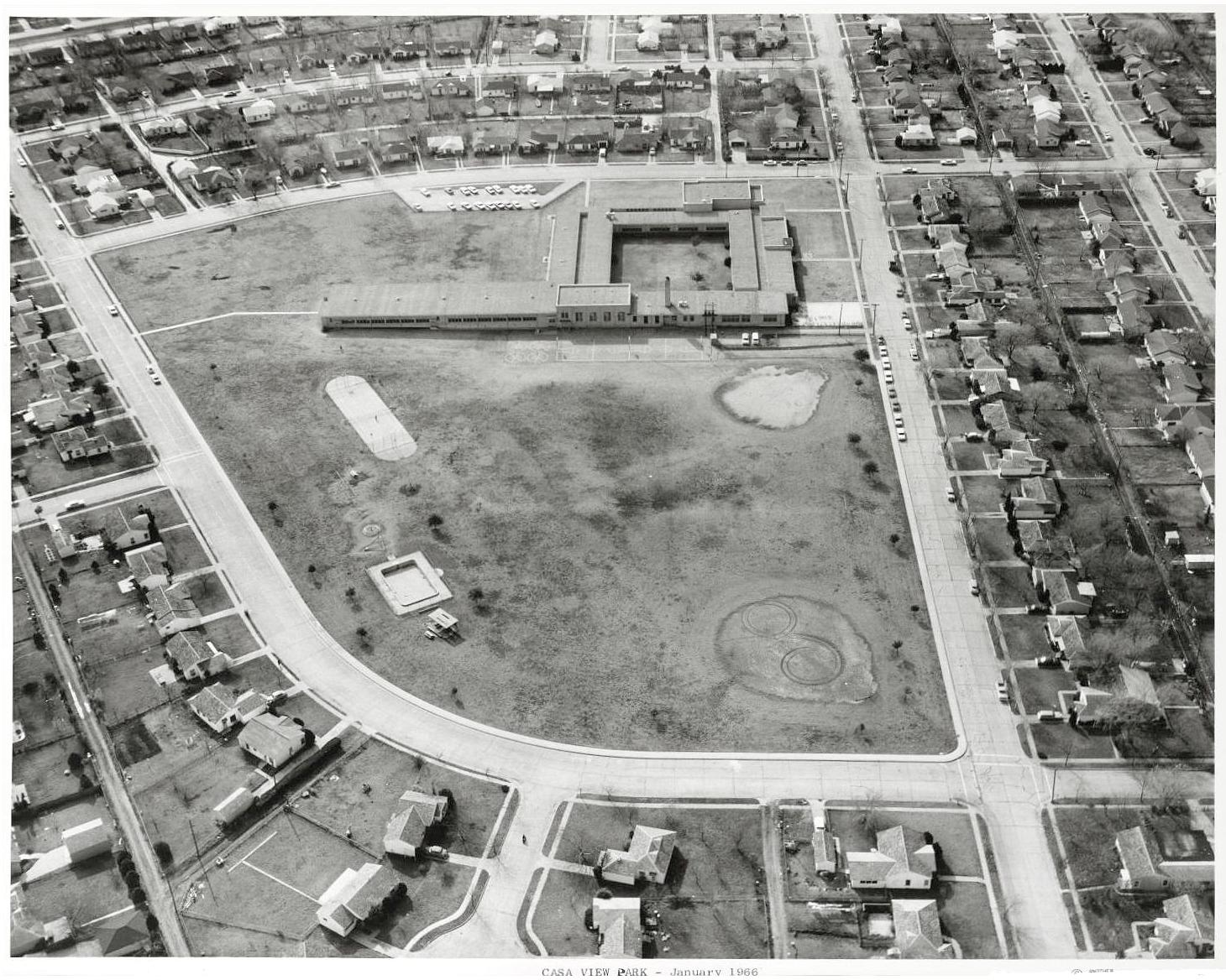
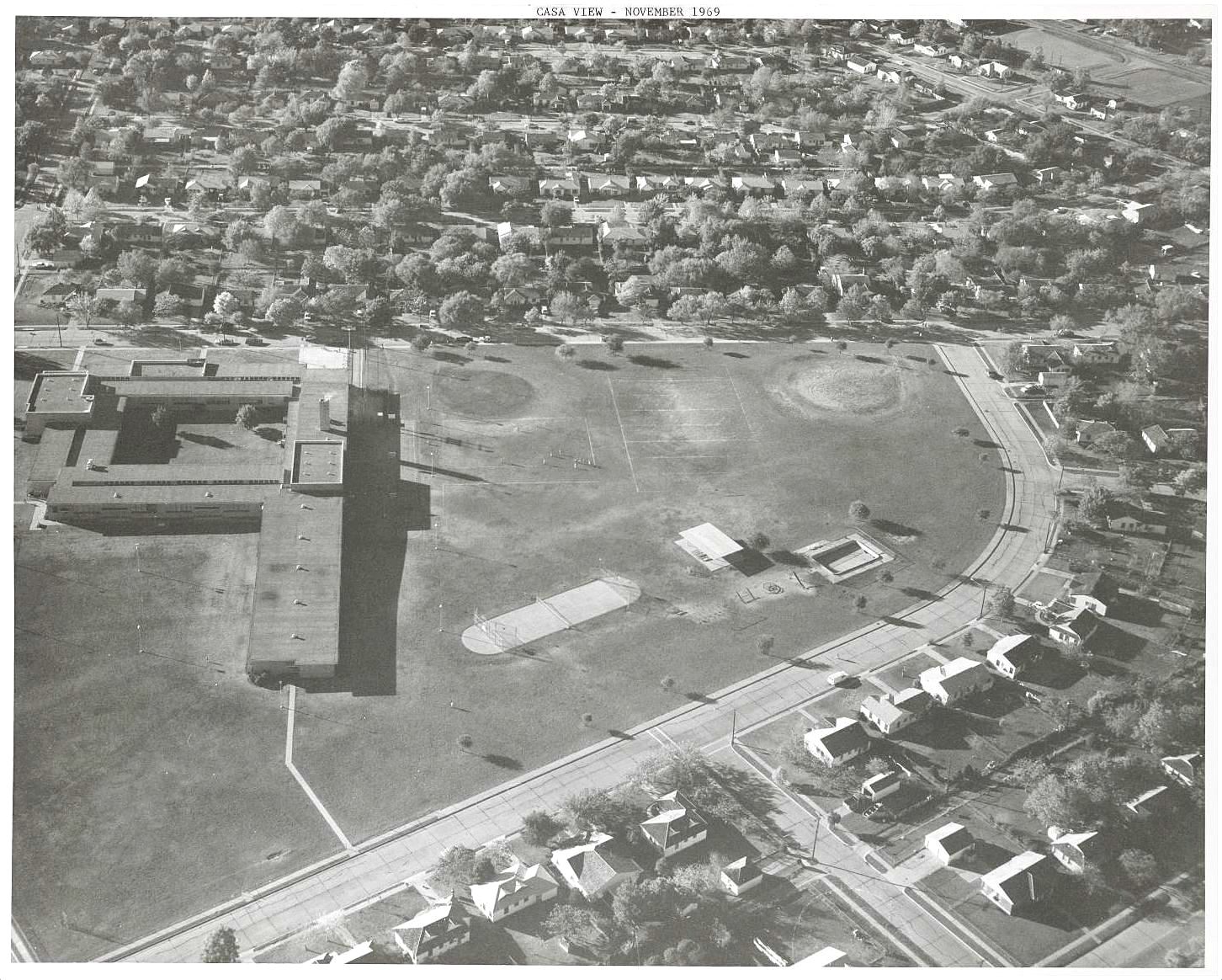
Below are four aerial photos showing the Casa View park and school, taken over a 20-year period by Squire Haskins. (All images are larger when clicked.)
*
At the top: a photo from 1954, with the year-old Casa View Elementary School on the left (in its original square shape, with an unusual-for-the-time open courtyard in the center); the fairly bleak-looking, treeless Casa View Park is on the right. The view is to the west, with Farola at the top, Monterrey on the left, and Itasca at the bottom and right.
Below, from January, 1966 — a view toward the south:
November, 1969 — looking west:
August, 1974 — looking east:

*
Below, with annexation under their belt (and assurance of city services, schools, etc.) developers’ ads like this one began appearing in local newspapers, hoping to entice prospective homeowners to the brand new “Casa View Heights” addition. (The description of these modest homes as “luxury” was a bit of a stretch….)
 October, 1949
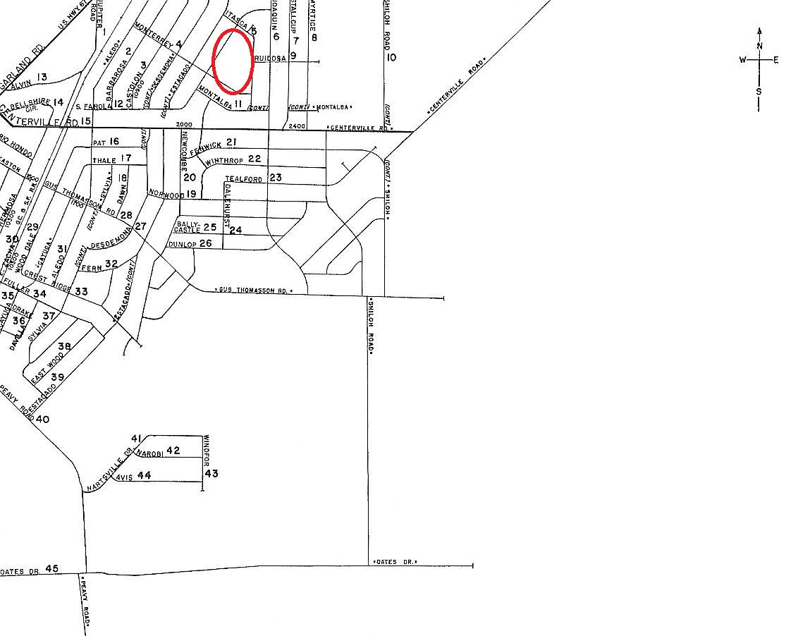
Here are a couple of interesting pages from the 1952 Dallas Mapsco. Take a look at all that empty white space just waiting to be gobbled up by an ever-sprawling Big D. (The location of the park and school is marked in the second image.)

***
Sources & Notes
The aerial photos are from the Dallas Municipal Archives, and are included in the collection “Dallas Parks Aerial Photographs” provided to UNT’s Portal to Texas History site; all photos above can be found here.
The location of the school and park can be seen here. A present-day aerial view from Google is here.
*
Copyright © 2018 Paula Bosse. All Rights Reserved.

[…] See aerials of nearby Casa View Park — taken by Squire Haskins between 1954 and 1974 — in the Flashback Dallas post “Casa View Elementary/Casa View Park — 1954-1974,” here. […]
LikeLike
Enjoyed this post so very much because we lived on Monterrey across from the auditorium side of Casa View School when my three children attended. We loved the neighborhood back then cannot remember any type of crime nearby. Swimming pool was open in the summer and my boys would take their go-cart all over the grounds.
LikeLiked by 1 person
Glad you liked it, Joyce!
LikeLike
If you grew up living in an old house that had been subdivided into apartments with the bathroom down the hall, then got drafted into the Army and went through four years of combat in the Pacific, sleeping wherever and whenever you could, then came back home to find all the housing was occupied so you and your new wife and baby had to live in a two room garage apartment –
Yes, being able to buy a 3 BR/1 bath house with mod-cons on your GI bill benefits was TRULY LUXURY.
LikeLiked by 1 person
Paula thanks for this post on the neighborhood I grew up in! I am Joyce’s daughter. I attended Casa View Elementary from Sept 68- March 1973. That pool, playground, tennis court at the park are filled with wonderful memories. I roamed that neighborhood on my bike for many years. Such a wonderful place to grow up. Our home seemed “old” when we moved in, with original hardwood floors, small galley kitchen, and one hall bath. It originally had two bedrooms but someone added a third on to the back before we moved it. I will never forget the floor furnace that kept the entire house warm in the winter. We had no a/c until later, when we added a huge window unit that cooled the whole house. It seems crazy that five of us lived there with really no space issues that I can recall. We had less STUFF! Fun times!
LikeLiked by 1 person
Thanks for the comment, Angela!
LikeLike
Paula, thank you so much for the article and the associated pictures. My family was original owners of a house on Tisinger Street, near the intersection of HWY 78 and Barnes Bridge Road. The lot behind our house is still vacant. As a child I was curious why, just a few houses away, Tisinger Steeet changed to Aledo Drive.
I’m thinking we moved there about 1954. I attended Casa View Elementary from the Fall of 1956 to the Spring of 1960, 1st through 4th grade. Casa View Elementary survived the Dallas Tornado of 1957. I recall that day actually doing the “duck and cover” drill in the hallway that we had practiced so many times. The school had fire in the building, perhaps during the summer of 1958. The fire was extinguished with limited damage. The school building was restored but classrooms maintained the “burnt wood” smell for some time.
I am very appreciative of Angela’s comments and confirm her memories of a “wonderful place to grow up” neighborhood. Similar to Angela, we were also a family of 5 in 3BR/1B, no A/C, but we did have a WATER FAN.
Your pictures are amazing and meaningful. I learned to swim in the park pool shown. Terrific memories there. We played all the sports on the school/park fields. We had tons of friends and great classmates.
My father died in the Spring 1959 and were comforted by a great group of neighbors/friends. My mother re-married and we moved to Oak Cliff in the summer of 1960, but I will never forget growing up in CASA VIEW.
I still love the area and pass by it often as we make our way to Dallas Arboretum quite often. I have taken my children and grandchildren by the house and Casa View Elementary/Park many times to share my memories.
I have reached out and connected with a couple my old neighbors and I am hoping to find more, perhaps through your meaningful website.
LikeLiked by 1 person
Thanks for sharing your memories, Larry! Here are other posts I’ve written on Casa Linda/Casa View: https://flashbackdallas.com/category/neighborhoods/casa-lindacasa-view/
LikeLike