Flashback : Dallas

A Miscellany: History, Ads, Pop Culture

Category: Photographs

On the Line at Coca-Cola — 1964

patreon_coca-cola-bottling-plant_john-rogers_portal_ca-circa-1964Gleaming!

by Paula Bosse

The photo above shows the sunniest factory floor I’ve ever seen. You don’t think of factories filled with sunlight, but this is what it looked like inside the new Coca-Cola bottling works at Lemmon and Mockingbird in 1964. It’s gone now (as is that UNBELIEVABLY FANTASTIC ANIMATED NEON SIGN that made me look forward to nighttime drives to Love Field). All that remains is the small syrup plant (from 1948?). (…I think it’s a syrup plant. Or a warehouse. Or something syrup-related.)

The new plant opened in June 1964. The building had floor-to-ceiling glass — I’ve read reminiscences of people who remember driving by and seeing the work going on through those huge windows. I don’t know if there was bottling work going on after dark, but here’s a grainy photo from a Dallas Power & Light ad that shows the building at night, lit up like a stage.

patreon_coca-cola_opening_060964_dpl_night_det-1Dallas Power & Light ad (det), June 1964

Speaking of which, The Dallas Morning News wrote this:

The bottling room, which fronts on Lemmon, has a glass front 254 feet long and 26 feet high to provide a view of the bottling process to the passing public. (DMN, June 9, 1964)

Free show!

The woman featured in an Employers National Life Group Insurance Company ad (below), might be the same woman seen in the photo at the top. Manning her station.

patreon_coca-cola_opening_060964_ad-det_employers-natl-life-group-insuranceEmployers National Life ad (det), June 1964

And what was rolling off the automated line? Coke, Sprite, and Tab. And something called Mission (grape and orange drinks). 1,860 bottles a minute (!).

Back to the sign for a second. I haven’t invested a LOT of time in a search (but *kind of* a lot…), but I have been unable to find footage of that truly wonderful, mesmerizing neon Coca-Cola sign. Living in an age of Instagram and YouTube, we just expect to find this sort of thing quickly, without having to set aside large chunks of time to devote to searching. If YOU know where film/video of that sign might be hiding… SPEAK UP!

A couple of shots of the exterior:

patreon_coca-cola-bottling-plant_john-rogers_portal_ext_ca-circa-1964

patreon_coca-cola-bottling-plant_john-rogers_portal_exterior_ca-circa-1964

***

Sources & Notes

Top photo and last two photos are all by John Rogers and were probably taken around the time the plant began operation in mid-1964; all are from the John Rogers and Georgette de Bruchard Collection, UNT Libraries Special Collections, via the Portal to Texas History, here, here, and here.

A shorter version of this post previously appeared on the Flashback Dallas Patreon page in November 2023.

patreon_coca-cola-bottling-plant_john-rogers_portal_ca-circa-1964

*

Copyright © 2024 Paula Bosse. All Rights Reserved.

The Grading of Junius — 1903

junius-street_wilson-home_1903_ebay_front_bwLet the scraping begin!

by Paula Bosse

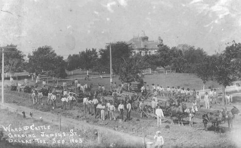
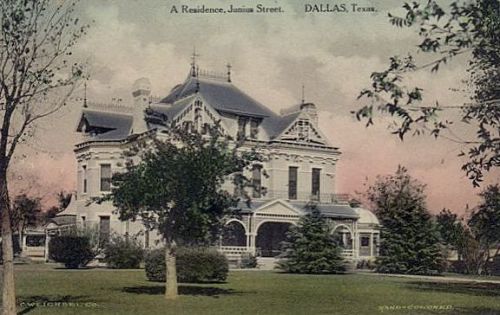
Here’s an interesting photograph I stumbled across on eBay. It shows Junius Street in East Dallas, between Peak and Carroll, taken in September 1903, as workers were grading the street as part of the paving process. The mammoth house seen on what looks like a hill, belonged to John B. Wilson (namesake of the Wilson Building downtown), who had purchased the grand home from Thomas Field in the 1890s. (This beautiful house — built in 1884 — was demolished in 1922 in order to free up land for apartments, etc. Read more about this in the 2014 post “Junius Heights … Adjacent!”) Here’s Wilson’s home, up close:

junius-st

The house was built in 1884 at the northeast corner of Junius and Peak — it sat on a lot of land. By 1903, after other houses had been built around it, it occupied almost half a block, bounded by Junius, Peak, and Gaston. (See this area on Sanborn maps from 1905 and 1922 — it’s pretty easy to spot the house!)

But back to the 1903 photo. It shows road work on Junius, which, up until that point, had been a dirt/gravel road.

In March 1903, residents of Junius Street asked the City Council to pave their street between Haskell and Fitzhugh. I’m sure their main goal was to live on a nice, paved street instead of one that became a nasty, muddy nightmare when it rained — but, perhaps to make it seem more egalitarian, they zhuzhed up their request by saying that Junius street is the principal outlet to Garland, Reinhardt and the country surrounding those towns.” They noted that the county had kept the continuation of the road outside the city in good condition and that this stretch of paved road would provide “a connecting link between the city and the country.” (I don’t know how important this “connecting link” was, but the stretch of road they wanted paved was only half a mile long. It seems pretty ballsy to request that the city pave this very short bit of road, which would have resumed being unpaved east of Fitzhugh…. and on to Garland and Reinhardt. I think there’s no question that Moneyed Resident Wilson — who, let’s not forget, was building the very large Wilson Building downtown at this time — had a lot of sway amongst the city leaders.)

The group approached the city with a proposition in which they, the homeowners, would pay for half the cost of the construction, with each of them paying 50¢ for every foot of their property which fronted the street. (Surprisingly, only two property owners had an issue with this — one of them was Dr. Buckner of the Buckner Orphans’ Home (before it relocated to the ‘burbs, it was at 4120 Junius), who said the home did not have the funds for this, but he personally ponied up a $50 contribution, the equivalent of about $1,700 in today’s money.) The city seemed happy with this and agreed to match the $2,500 collected by the group. (Mr. Wilson’s share must have been substantial.) I don’t know what the tax situation was back then, but it’s odd that people once had to do this. I would guess that very few streets were paved beyond the Central Business District in this era — who could afford that? I guess that’s why so many real estate ads from the past stressed that the streets of their new developments were all paved.

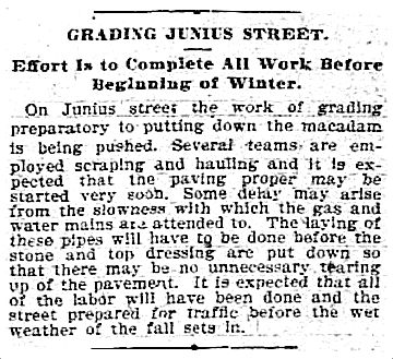
The Junius improvements included the laying/installing of cement sidewalks, a macadamized roadway, and bois-d’arc-block gutters. The grading work (shown in the photo at the top) began in August 1903.

junius_grading_DMN_082503Dallas Morning News, Aug. 25, 1903

There were, of course, delays, caused by a lack of materials, weather, the necessity of having to wait while gas and water mains were laid, and having to either rebuild a bridge over the road or build a culvert under the road (the city went with the cheaper culvert). Work was still going on in December, but I gather the job was completed early in 1904.

*

Leadership of the neighborhood group was comprised of two people from each block (one from each side of the street). The leaders for what is now the 4700 block of Junius were John C. Ward and C. J. Castle (their names are on the photo showing this work in progress). The notation below is written on the back of the photo: “J. B. Wilson home in background (built Wilson Building downtown). J. C. Ward my grandfather. Mary Musick.”

junius-street_wilson-home_1903_ebay_back_det

J. C. Ward (1851-1937) came to Dallas in 1874, traveling in a covered wagon, witnessing buffalo stampedes and white-knuckling it through Indian territories. He was pals with an elderly John Neely Bryan. He worked as a contractor and must have done well, as he owned houses on several lots in the 4700 block of Junius, most of which were occupied by family members (including his daughter, Ella Ward Arnold, and his granddaughter, Mary Arnold Musick) — his own home was in the 6100 block of Junius, which appears to be the current location of the Lakewood Library. At one point he owned 72 acres of farmland on the eastern edge of Dallas, but it was condemned by the city in order to build White Rock Lake. He didn’t seem to hold too much of a grudge, because his major pastime was fishing, and he frequently walked the 2 miles to the lake from his home to fish, well into his 80s.

He seems to have had a real affinity for Junius Street. I love the fact that he and his across-the-street neighbor, C. J. Castle, memorialized the paving of their street with a specially commissioned photograph and managed to get all the workers to pose for it. The paving of Junius must have been a particularly gratifying achievement.

***

Sources & Notes

Top photo is from eBay — it is currently for sale, here.

If you enjoy this sort of thing, check me out on Patreon, where, for a subscription costing mere pennies a day, you can receive daily, bite-size Dallas-history posts directly in your inbox.

junius-street_wilson-home_1903_ebay_front_bw

*

Copyright © 2024 Paula Bosse. All Rights Reserved.

The South End “Reservation” Red-Light District — ca. 1907

south-end_hobson-electric_southeast-from-courthouse_ca-1907_cook-collection_degolyer_SMUThere’s a lot going on here that you can’t see… (DeGolyer Library, SMU)

by Paula Bosse

I am reminded how much fun it is to just dive into something with no idea where you’re heading and end up learning interesting things you might have been unaware of had you not wondered, “What am I looking at?”

Yesterday I was working on a future post that involves the Hobson Electric Co., and I was looking for photos. The one above popped up in one of my favorite collections of historical Dallas photos, the George W. Cook Collection at SMU’s DeGolyer Library. I was looking for a post-1910 West End photo — this photo is identified as just that [the title has now been updated by the SMU Libraries], but the presence of the Schoellkopf Saddlery Co. building (center left, with the Coca-Cola ad on it) puts this location on the other side of the central business district — Schoellkopf was at S. Lamar and Jackson. Even knowing that, this scene didn’t look familiar at all.

I checked a 1907 city directory to find out the address of the Hobson Electric Co. before it moved to the West End in 1910 — it was located at 172-74 Commerce Street (in what is now the 700 block), between S. Market and S. Austin. The view here is to the southeast, probably taken from the courthouse.

I don’t think I’ve seen this particular view before — it shows hardly any of the downtown area but shows instead the area to the south. I was really intrigued by the block of houses facing Jackson (between Market and Austin) — the block the horse-and-buggy is moving past, at the center right. The trees. The low buildings. That block really stood out. It was kind of quaint. Did people live there? While I had the 1907 directory open, I checked to see who the occupants were. (I just picked 1907 because the Hobson Co. changed its name from “Duncan-Hobson” around 1906, and it had moved away from Commerce by mid 1910.) Here were the occupants of those houses in 1907:

jackson-between-market-and-austin_1907-directory1907 Dallas directory

That seemed odd. Three single women occupying three separate houses, all next-door to one other. There weren’t a lot of single women living in houses alone in 1907. Hmm. I checked all the directories between 1905 and 1910 to see who was living in that block. Every year, each of those houses showed a new occupant, and, with one exception, all were single woman (the exception was a man who owned a saloon across the street and who had faced charges at one point for “keeping a disorderly house”). …Okay. I got the picture.

I checked the Sanborn map from 1905 for this block and saw something I’d never seen before: the designation of a building with the letters “F.B.” What did that mean? Turns out, it means “Female Boarding House.” Or, less euphemistically… a brothel. Look at the map here (more maps are linked at the bottom of this post) to see the frankly ASTRONOMICAL number of “F.B.” buildings in this one small area. (There weren’t as many saloons — designated with “Sal.” — as I expected, but I’m pretty sure a lot of saloons in this area were operating illegally.)

You might have noticed that all of those F.B.s are south of Jackson. Not one of them is north of Jackson. This area — the southwestern part of downtown — was referred to at the time as the “South End” or “The Reservation” (some called this general area “Boggy Bayou,” but I think that was technically farther south). Its boundaries were, basically, S. Jefferson Street (now Record Street) on the west, Jackson on the north, S. Lamar(-ish) on the east, and beyond Young Street on the south. If you wanted to avail yourself of illicit things and engage in naughty behavior, this was the place for you: Ground Zero for a sort of wide-open, lawless Wild West. There were other red-light districts in Dallas (most notably “Frogtown,” which was north of downtown in the general area formerly known as Little Mexico) (can we still call this now-over-developed area “Little Mexico”?), but if you wanted the primo experience of one-stop-shopping for drinking, gambling, drugging, and “resorting with fallen women,” you were probably familiar with the South End, where all of these activities were tolerated and, for the most part, ignored by the police (they might mosey by if there were an especially egregious shooting or stabbing or robbery). In fact, this vice-filled area had been created by a helpful city ordinance in the 1890s. So enjoy!

Prostitutes were allowed to ply their trade in this specified chunk of blocks because the city fathers felt that it would be best to keep all that sort of thing in one somewhat controllable area, away from the more reputable neighborhoods. But once a prostitute stepped outside the Reservation to sell something she shouldn’t have been selling… laws suddenly applied, and she’d be thrown in jail and/or fined. Do not step north of Jackson!

So, at one time, Dallas had legal brothels. Depending on whose account you read, these houses of ill repute ranged from godawful “White Slavery” operations and bubbling cauldrons of sin and sleaze to, as Ted Dealey remembers in his book Diaper Days of Dallas (p.74), “ultra-fashionable houses of prostitution” which attracted Big D’s moneyed movers and shakers. Something for everyone.

Eventually, people started to get really bent out of shape about this, and there was a big push to get these houses shut down — or at least moved out of the area. The Chief of Police reported to the City Council in 1906 that, among the many Reservation-related problems, the area was getting cramped because the railroads were buying up real estate in the area and kicking people out. The city-sanctioned no-man’s land was getting too small, so city officials needed to find a bigger place to move the red-light district to. The Chief thought that North Dallas (i.e. Frogtown) was “the most logical place” — except that residents of nearby swanky neighborhoods there were not at all keen on this. But that idea seemed to stick. It took several years to actually happen, but a relocation of sorts occurred, and the South End brothel-hotspot was pretty much scrubbed of all offending “disorderly houses” by 1910. (Frogtown bit the dust around 1913, after those unhappy well-to-do North Dallas neighbors complained bitterly, loudly, and effectively.)

So, anyway, I never expected to find such an exciting photograph! I wonder if the photographer took this photo as a way of documenting the very controversial, in-the-news, not-long-for-this-world Reservation, or whether it was just a nice scenic view. I have to think it was the former, because the Reservation was well-known to everyone, near and far, and this shot would have been an unusual vista to, say, reproduce for postcards (or at least postcards sold to the general public!). Whatever the case, I’ve never seen this view, and it’s really great — and it comes with an interesting slice of Dallas history. I had heard of the Frogtown reservation to the north, but I’d never heard of the South End reservation. And now I have. And here’s a photo of it!

Let’s bring back the neighborhood designation of “South End.” It was good enough for 1900, it’s good enough for today.

*

Here are a few zoomed-in details of the photo. Unless I’m imagining things, I think I can see women sitting on their porches, advertising their wares, as was the custom. (All images larger when clicked.)

south-end_cook-collection_degolyer_SMU_det-1

*

south-end_cook-collection_degolyer_SMU_det-2

*

south-end_cook-collection_degolyer_SMU_det-3

*

Below is an excerpt from a blistering directive to city lawmakers by W. W. Nelms, Judge of the Criminal District Court (from an article with the endless headline “Calls For Action; Judge Nelms Charges Police Chief, Sheriff and Grand Jurors; Warfare on Crime; Says Lawbreakers Shall Not Construe Statutes of State to Suit Themselves; Stop Murder and Robbery; Declares Harboring Places for Thugs, Thieves and the Like Must Be Destroyed,” Dallas Morning News, Oct. 15, 1907).

reservation_judge-w-w-nelms_DMN_101507DMN, Oct. 15, 1907

*

Below, the general area of the South End Reservation around 1907 (this map is from about 1898). The blue star is the Old Red Courthouse; the Reservation is bordered in red. In 1893, the original area was loosely designated as the area bounded by Jackson Street, Mill Creek, the Trinity River, and the Santa Fe railroad tracks, in which “women of doubtful character […] were not to be molested by police” (from “Passing of Reservation,” DMN, Dec. 11, 1904). As noted above, the area shrank over time, and the red lines show the general Reservation area about 1907, the time of the photo at the top.

south-end_reservation_1898-map_portalDallas map, ca. 1898 (det), via Portal to Texas History

***

Sources & Notes

Top photo — “[Jackson Street, Looking [Southeasterly from the Courthouse, Including a Partial View of the South End ‘Reservation’]” (previously incorrectly titled “[Dallas West End District with View of Railroad Yards]”) — is from the George W. Cook Dallas/Texas Collection, DeGolyer Library, SMU Libraries and can be accessed here. (I appreciate SMU for responding to my request to re-title and re-date this photograph — it’s always worth notifying archival collections with corrections!) (And, as always, I WELCOME corrections. I make mistakes all the time!)

The 1905 Sanborn map I linked to above (Sheet 104) is here and seems to be the epicenter of the booming brothel trade; more evidence of this can be seen just south of that in Sheet 102; and it continues just east of that in Sheet 105 (it’s interesting to note the specially designated “Negro F.B.” bawdy houses). (Sanborn maps do not open well on cell phones — or at least on my cell phone. You may have to access these from a desktop to see the full maps. …It’s worth it.)

Read more about this whole “Reservation” thing in the lengthy and informative article “Not in My Backyard: ‘Legalizing’ Prostitution in Dallas from 1910-1913” by Gwinnetta Malone Crowell (Legacies, Fall 2010).

Also, there’s a good section on this (“Fallen Women”) in the essential book Big D by Darwin Payne (pp. 48-56 in the revised edition).

If you enjoy these posts, perhaps you would be interested in supporting me on Patreon for as little as $5 a month — in return, you have access to (mostly!) exclusive daily Dallas history posts. More info is here.

south-end_hobson-electric_southeast-from-courthouse_ca-1907_cook-collection_degolyer_SMU_sm

*

Copyright © 2024 Paula Bosse. All Rights Reserved.

Colony Club Billboard in Beautiful Kodachrome — Early 1960s

kodachrome_elm-ervay-live-oak_chris-colt_colony-club-billboard_ebay_WATERMARKDowntown Dallas has it all…

by Paula Bosse

This. Is. A. Fantastic. Photo.

If only for the great, great, great Colony Club (“the best of the undressed”) billboard featuring Chris Colt (“the girl with the 45s”).

See this same view of the (one-time) intersection of Elm, Ervay, and Live Oak here and here. (The dazzling animated neon Coca-Cola sign was once where Chris Colt is showing off her 45s.)

I almost never post images with watermarks, but this photo is pretty spectacular. Look around the watermark!

I don’t know the seller of this color slide. I have no affiliation with the person. I get no cut in any sale. But I want someone reading this to BUY IT! Let’s keep this with someone who loves Dallas history! (And if you DO buy it and would like to send me a digital copy… well, I wouldn’t say no!) See this slide currently on eBay HERE. (HURRY!)

To see a naughty photo of Chris Colt, you can click on an antique collectors’ website here.

colony-club_ad_chris-colt_112262Colony Club ad, Nov. 22, 1962

And below is a photo of Colony Club owner Abe Weinstein in his younger years counting his moolah.

abe-weinstein_abe-and-pappys_djhs-facebookphoto: Dallas Jewish Historical Society

***

Sources & Notes

Top image is from a color slide in a current eBay listing here. (Seller’s title: “Original Slide Dallas St Scene Colony Club Coca Cola Billboards Southland Life.”) There is no date, but Golden Steer Barbecue opened at 1713 Live Oak sometime in 1961.

Abe Weinstein photo — from his days as the co-owner of Abe’s and Pappy’s — is from the Facebook page of the Dallas Jewish Historical Society.

kodachrome_elm-ervay-live-oak_chris-colt_colony-club-billboard_ebay_WATERMARK_sm

*

Copyright © 2023 Paula Bosse. All Rights Reserved.

Jack Walton’s Hot Barbecue

jack-waltons-barbecue_bell-collection_DHS_ca-1946_3a
Restaurant No. 1, Haskell & San Jacinto…

by Paula Bosse

Arden Lee “Jack” Walton was born in Panola County (on his World War I registration card, he listed his home as Fairplay, Texas, which a town name I’m certainly glad to know exists). After the war, he moved to Dallas and opened his first restaurant — Walton’s Place — around 1925 or 1926. By the 1930s, he seems to have settled on barbecue as his primary specialty and had several of his self-named restaurants/drive-ins around town, branching out to Fort Worth in the early ’40s.

The photo above, from about 1946, is probably Walton’s first location, at Haskell and San Jacinto in Old East Dallas. The two photos below — showing a man working on the neon sign — were taken at the same time. (The photographer, James Bell, was a Dallas native back in town visiting — he took tons of unusual photos, often focusing on trucks, buses, cars, juke boxes, and various coin-operated machines. I’m sure he liked the look of the truck. They’re definitely amateur photos, but they’re great.)

jack-waltons-barbecue_bell-collection_DHS_ca-1946_2

jack-waltons-barbecue_bell-collection_DHS_ca-1946_1

The photo that crops up on places all over El Internet (the photo below) is one which has a variety of conflicting information attached to it, including photographer, date, and location. As far as I can tell, I think the photo was taken by Arthur Rothstein in Fort Worth, in the very early ’40s (the FW location, at 1900 E. Lancaster, opened around 1940). I think most of the locations had a similar design. (See a typical menu here.)

jack-waltons-barbecue_traces-of-texas_arthur-rothenstein_ca-1943_cropped

Here’s another photo (location unknown):

jack-waltons-hot-barbecue_smokelore_bookfrom the book Smokelore

jack-waltons-barbecue_worthpoint_menu-back

jack-waltons-barbecue_worthpoint_menu-front

Walton was very successful in his toasted sandwich endeavors (he also made some savvy real estate deals). When he died, he was described as “the barbecue baron of Dallas.”

…When he died. Jack Walton died on Feb. 19, 1960, at the age of 62. He was visiting one of his restaurants, at Tom Field Circle and Hwy. 183. The manager — Jack’s brother-in-law — had been drinking on the job, and Jack fired him on the spot. So the brother-in-law shot him, telling the police later that Walton “started fussing at me and told me to get out.” He shot him at close range, so inebriated that only two of the shots hit their target. He was DOA at Baylor. (Read the AP wire story here.)

At least one of Walton’s restaurants was taken over by the Semos family — the Haskell location lasted under non-Walton management for quite a while.

*

When I saw this matchbook cover several years ago, I was quite taken with the phrase “toasted chicken loaf.” What was a “chicken loaf”? I have to say, it didn’t sound that appetizing.

jack-waltons-BBQ_matchbk_1

jack-waltons-BBQ_matchbk_2

Chicken loaf was (apparently) a very popular food in days gone by, similar to meat loaf (it was made with chopped, shredded, or minced chicken, eggs, breadcrumbs/rice/some sort of cereal, etc., with the addition of hard-boiled eggs and/or pimentos and/or peas and/or whatever else was lying around). There are lots of ads in newspapers beginning around 1900 showing it as a “potted” meat, sold in cans alongside Underwood Deviled Ham and Vienna sausages, etc. I can understand this as a cost-saving meal during the Depression, but it was also very popular in restaurants (several local restaurants advertised that they sold entire take-out “loafs”), and it was a favorite of many as a Sunday dinner (or as a way to use leftover chicken in the pre- and post-casserole days). By the ’40s, recipes started adding the dreaded gelatin (“Jellied Chicken Loaf”). Um, yes. There was also … wait for it … MOCK chicken loaf! I’m not sure what that was, but it probably got people through WWII and food-rationing.

While searching for “chicken loaf” info in the Dallas Morning News archives, I saw a few delicacies listed in grocery ads which one might be hard pressed to find on the shelves of one’s local supermarket today: oyster loaf, liver loaf, and deviled tongue — all sold in cans. There was also a New Year’s Eve recipe in there for “Hot Sardine Canapes,” with toast “cut in fancy shapes.”

FYI.

***

Sources & Notes

First three photos were taken by James Bell in about 1946; they are from the James H. Bell Collection, Dallas Historical Society — they can be accessed here, here, and here. (I have straightened and cropped the photos.)

The photo which is probably by Arthur Rothstein is from the Traces of Texas Facebook page.

Menu detail art is from Worthpoint; matchbook scans from eBay.

jack-waltons-barbecue_bell-collection_DHS_ca-1946_1_sm

*

Copyright © 2023 Paula Bosse. All Rights Reserved.

Elm Street Store: Whiskey, Brooms, Cigars

elm-street-store_whiskey-broomsEverything one needs…

by Paula Bosse

What more do you need in life than a gallon of whiskey, wine, or gin? And maybe some brooms. And a butter churn. The essentials. I don’t know anything about this photo, except that it does appear to be Dallas — you can see “Elm St.” on the brick wall at the left, just above an ad for Dallas cigar king P. P. Martinez. Not sure when the photo was taken — 1890s-ish? Below is a P. P. Martinez ad from 1908.

ad-martinez-cigars_dmn_050308

It’s hard to make out the “Special Prices” sign above the doorway, but some of the items you could purchase were rock and rye whiskey ($1.25 a gallon), port wine ($1.25 a gallon), and Holland gin (“only $1.50 per gallon”).

I had never heard of “rock and rye” whiskey until a few minutes ago. It was a whiskey cordial made with rock candy (!) and some sort of citrus or other flavor. So I’m guessing it was pretty sweet and powerful. It was often sold as a “tonic” because taxes were substantially less on medicines than on spirits. So goodbye, saloon staple, hello cough medicine! “Rock and rye” has made a recent comeback among whiskey-quaffing hipsters.

***

Sources & Notes

I have no idea where I found this photo back in 2014, but it’s great!

This post appeared in a slightly different form on my Patreon page a few months ago. If you’d like to receive daily Dallas-history postlets, check it out!

elm-street-store_whiskey-brooms_sm

*

Copyright © 2023 Paula Bosse. All Rights Reserved.

1500 Block of Elm — 1920s

fields-millinery_1512-elm_frank-rogers-ebay1500 block of Elm Street, south side…

by Paula Bosse

This is a great photo by Frank Rogers showing businesses on the south side of the 1500 block of Elm Street, between Stone and Akard (see it today on Google Street View here — some of these buildings are still standing). Mid-1920s? Back when Elm ran two ways, and you could park your rumble-seated roadster at the curb.

Mostly out of frame at the left is the W. A. Green department store (1516-18 Elm), then, moving east to west, Leelands women’s fashions (1514 Elm), Fields Millinery Co. (1512 Elm), part of the Marjdon Hat Shop (1510 Elm), and, above the hat shop, Neuman’s School of Dancing. (“Marjdon” must be one of the most annoying and hard-to-say business names I’ve come across.)

The block continues in the photo below, in another photo by Rogers (this building has been replaced and is now a parking garage).

thomas-confectionary_1508-10-elm-st_frank-rogers-ebay

We see a full shot of Marjdon (that name…). Previously (1916-1924), that street-level space was occupied by the Rex Theater. Next door is Thomas Confectionery (1508 Elm, one of the company’s several downtown locations), which, according to the promotional postcard below was the “largest confectionery in the state.”

thomas-confectionary_postcard_1911_sam-rayburn-house-museum-via-portalvia Portal to Texas History

*

thomas-confectionary_main-high-school-yrbk_1916Dallas High School yearbook, 1916

*

marjdon_1510_opening_030124March 1, 1924

*

fields-millinery_1512-elm_dmn_opening_042122_adApril 21, 1922

*

leelands_030125March 1, 1925

*

elm-street_dallas-directory-1925_1500-blockElm Street, 1925 Dallas street directory

*

Check out this block in the 1921 Sanborn map here.

***

Sources & Notes

The two photographs were taken by Dallas photographer Frank Rogers for real estate developers McNeny & McNeny; they were found on eBay.

fields-millinery_1512-elm_frank-rogers-ebay_sm

*

Copyright © 2023 Paula Bosse. All Rights Reserved.

Ex-Slaves in Dallas — 1937

ex-slave_william-moore_WPA_LOC_122137William Moore

by Paula Bosse

These six portraits of ex-slaves who were living in Dallas in 1937 were included in Born in Slavery: Slave Narratives from the Federal Writers’ Project (Works Progress Administration/Work Projects Administration — WPA). See all of the Dallas portraits here.

UPDATED: Thanks to a comment from a reader, I’ve linked to the oral histories of those photographed. Click the links below the photos to read about their lives.

**

Above, William Moore was born in Selma, Alabama about 1855; in 1937 he was living at 1016 ½ Good Street in Dallas.

*

Below, Emma Watson was born in Ellis County about 1852; in 1937 she lived at 318 Allen Street.

ex-slave_emma-watson_WPA_LOC_090537Emma Watson

*

Mose/Moses Hursey was born in Louisiana about 1855; in 1937 he lived at 1120 Tenth Street.

ex-slave_mose-hursey_WPA_LOC_120137Mose Hursey/Moses Hursey

*

Mary Ellen Johnson was born near San Marcos about 1860; in 1937 she owned a cafe at 1301 Marilla.

ex-slave_mary-ellen-johnson_WPA_LOC_ca-1937Mary Ellen Johnson

*

Callie Shepard/Shepherd was born near Gilmer in 1852; in 1937 she lived at 4701 Spring Avenue.

ex-slave_callie-shepard_WPA_LOC_ca-1937Callie Shepard/Callie Shepherd

*

Andrew Goodman was born near Birmingham, Alabama about 1840; in 1937 he lived at 2607 Canton.

ex-slave_andrew-goodman_WPA_LOC_120137Andrew Goodman

Update, Jan. 2024: I came across this portrait of Andrew Goodman by Dallas-trained artist Merritt Mauzey (1946, Smithsonian American Art Museum):

mauzey-merritt_andrew-goodman_portrait_smithsonian-art-museum_1946

*

From the Library of Congress site devoted to this project:

“Born in Slavery: Slave Narratives from the Federal Writers’ Project, 1936-1938” contains more than 2,300 first-person accounts of slavery and 500 black-and-white photographs of former slaves. These narratives were collected in the 1930s as part of the Federal Writers’ Project of the Works Progress Administration (WPA) and assembled and microfilmed in 1941 as the seventeen-volume “Slave Narratives: A Folk History of Slavery in the United States from Interviews with Former Slaves.”

***

Sources & Notes

As noted, all portraits from the WPA “Born in Slavery” project, hosted on the Library of Congress website.

Related posts from Flashback Dallas:

ex-slave_william-moore_WPA_LOC_122137_sm

*

Copyright © 2023 Paula Bosse. All Rights Reserved.

Dads’ Day at Hockaday — 1947

hockaday_dads-day_life-mag_cornell-capa_1947_cokesMid-day snack in Lower Greenville

by Paula Bosse

“Dads’ Day” at the Hockaday School for Girls, was a big thing. In this annual celebration, fathers (many of whom traveled from other states) would spend a few hours on the campus with their daughters, attend special programs and performances, visit classrooms, engage in friendly sporting matches against their daughters (volleyball, softball, kickball), and enjoy refreshments. In 1947, there was an al fresco Coke and hamburger lunch. But the big event was that night: a formal dinner in the Crystal Ballroom of the Baker Hotel. And, luckily for us, the Dads’ Day festivities of February 1947 were captured by Life magazine photographer Cornell Capa. A few of the photos appeared in the March 10, 1947 issue, in the story “Dad Has His Day; Texas Schoolgirls Invite Fathers to Come and Be Dates for a Day.” This Dads’ Day story even got the cover. Below are photos by Capa which weren’t used in the story.

*

Dads watching one of several presentations in their honor:

hockaday_dads-day_life-mag_cornell-capa_1947_performance

*

Sitting in a classroom. I don’t know who this girl is, but I love this photo of her. (If readers recognize any of the people in these photographs, please comment below.)

hockaday_dads-day_life-mag_cornell-capa_1947_desk

*

Hangin’ with the girls, enjoying refreshments:

hockaday_dads-day_life-mag_cornell-capa_1947_indoors_cokes

*

Volleyballing with hats on (I love this photo!):

hockaday_dads-day_life-mag_cornell-capa_1947_game

*

Enjoying more refreshments (lotta Coke at Hockaday…). (Note Bosque Bonita in the background, the property’s original house, Greenville and Belmont. Read more here.)

hockaday_dads-day_life-mag_cornell-capa_1947_bosque-bonita

*

More refreshments on a chilly February day:

hockaday_dads-day_life-mag_cornell-capa_1947_lunch

*

Girls who attended Hockaday as a boarding school, in a dorm, making the paper crowns which fathers will wear at the formal dinner at the Baker Hotel:

hockaday_dads-day_life-mag_cornell-capa_1947_dorm

*

Below, Ann Seidenglanz (whose preparations for this big dinner were captured in the pages of Life — she even made the cover!) places a crown on her father’s head (Charles B. Seidenglanz):

hockaday_dads-day_life-mag_cornell-capa_1947_crown

*

I don’t know who these people are, but I love this photo:

hockaday_dads-day_life-mag_cornell-capa_1947_baker-hotel

*

Jerrie Marcus was accompanied by her father, Stanley Marcus. (Jerrie Marcus Smith died in March of this year. Please check out the book she wrote about her great aunt Carrie Marcus — A Girl Named Carrie: The Visionary Who Created Neiman Marcus and Set the Standard for Fashion.)

hockaday_dads-day_life-mag_cornell-capa_1947_stanley-marcus_daughter - Copy

*

Miss Ela Hockaday, founder of the legendary school and, at the time of this photo, its president emeritus.

hockaday_dads-day_life-mag_cornell-capa_1947_miss-hockaday

***

Sources & Notes

Photos are by Cornell Capa, taken on assignment for Life magazine — none of the photos above appeared in the published article (March 10, 1947). See the published story here; see the photos Capa shot (almost all of which were never published) here. All photos Copyright: ©Time Inc.

hockaday_dads-day_life-mag_cornell-capa_cover_031047

None of the people in the photos above are identified, other than covergirl Ann Seidenglanz. And Stanley Marcus is obviously instantly recognizable to any Dallasite. If you can identify any of the others seen above, I’d be happy to add their names to this post.

Also, check out the lengthy Dallas Morning News story which preceded this Dads’ Day event (with studio photos of several fathers and daughters), in the DMN archives: “News of Women.” DMN, Feb. 9, 1947, Section III, p. 1, 2, 13.

More about the Greenville Avenue-era Hockaday campus can be found in the Flashback Dallas post “Belmont & Greenville: From Caruth Farmland to Hub of Lower Greenville.”

And you are always welcome to follow me on Patreon, where it’s Flashback Dallas every day, for as little as $5 a month.

hockaday_dads-day_life-mag_cornell-capa_1947_cokes_sm

*

Copyright © 2023 Paula Bosse. All Rights Reserved.

Schulte Cigars, Elm & Akard — ca. 1923

schulte-cigars_elm-akard_frank-rogers_ebay_frank-rogers_bw
Life at Elm & Akard…

by Paula Bosse

A. Schulte Cigars — at 1416 Elm — held down the southwest corner of Elm and Akard streets (Elm is in the foreground, with the streetcar tracks). The winsomely named Zesmer’s Bootery was at 1412 Elm. Around the corner on Akard was an orange-drink stand. Above the building was a surprising array of billboards. (There is a lot of advertising in this photo.) Here’s another view of the same block, looking west:

elm-st-color_1920s

Every time I see those curlicue lamp posts, they seem to be in photos of Elm Street.

zesmer_schulte_1400-block-elm_1923-directory1400 block of Elm, 1923 city directory

***

Sources & Notes

Top photo by Frank Rogers; found on eBay.

Color postcard from the Flashback Dallas post “Views of Elm Street, With Cameo Appearances by the Fox Theater — 1920s-1960s.”

A previous Schulte location was at 201 S. Ervay, which you can see in the amazing photo in the post “‘There Are Eight Million Stories in the Naked City…’ — ca. 1920.”

Please consider supporting me on Patreon for as little as $5 a month. I post exclusive content there daily!

schulte-cigars_elm-akard_frank-rogers_ebay_frank-rogers_sm

*

Copyright © 2023 Paula Bosse. All Rights Reserved.