Flashback : Dallas

A Miscellany: History, Ads, Pop Culture

Category: Neighborhoods

Jack Wilkie’s Texaco Station, Beacon & East Grand

wilkie-texacoA man with a bow-tie will be with you presently….

by Paula Bosse

Above, Jack Wilkie’s Texaco service station at 5523 East Grand. It’s a shame gas stations are rarely this interesting anymore. The station opened in 1937 and was at this location well into the 1940s. Below, the same view today, with that tall brick building in the background of both photos. (I’m not sure what that building is, but while I was waiting for a friend in the Kalachandji’s parking lot a few months ago, I remember thinking what a strange building it was — especially when seen from the side. It’s had some weird additions made to the original building.) This part of East Dallas still has pockets of charm, but it’s never again going to be as cool as it was when Jack Wilkie’s service station was holding down the fort at the corner of Beacon and E. Grand.

wilkie-google

***

Sources & Notes

Top image from Flickr, here.

Second image from Google Street View.

*

Copyright © 2015 Paula Bosse. All Rights Reserved.

Harley-Davidson Sales Co. Ad — 1929

ad-harley-davidson_directory_1929-smBeyond sidecars…

by Paula Bosse

I have to say, I love this delivery vehicle!

***

Advertisement from the 1929 city directory. Harley-Davidson — 2700 Commerce Street, at Henry — was in Deep Ellum, in the same block currently occupied by Angry Dog.

Click picture for larger image.

*

Copyright © 2015 Paula Bosse. All Rights Reserved.

Cole Park Storm Water Detention Vault

water-detention-vaultWhy, yes, this IS in Uptown…

by Paula Bosse

Underneath Cole Park (which is behind North Dallas High School and between Cole and McKinney), is a “storm water detention vault” — a cavernous space where storm water runoff goes when the capacity of the Mill Creek storm sewer system has been exceeded. It can hold 71 million gallons of storm water. …71 million gallons!

From a 2014 Facebook post from the Turtle Creek Association:

Completed in 1993, the vault’s 13 chambers, each of which rises five stories tall and runs the length of more than two football fields, are designed to fill with water during extreme rainfall. These massive vaults capture the storm water from Central Expressway and slowly release it into Turtle Creek via the Mill Creek Outfall by the footbridge in William B. Dean Park (next to the Kalita Humphrey Theater).

I had no idea that Dallas had anything like this until I saw the short film, below, in which Gilbert Aguilar, Assistant Director of the City of Dallas’ Department of Street Services, takes us on a tour of the “detention vault.” This is an absolutely mind-blowing look at something very, very few Dallasites know about. The City of Dallas probably wouldn’t be willing to grant access to moviemakers, but, seriously, this would make an INCREDIBLE movie set — perhaps less aesthetically appealing than the sewers of Vienna featured in The Third Man, but what it lacks in character it makes up for in sheer gigantic-ness.

***

Sources & Notes

The video, “Living With the Trinity: Cole Park Vault,” is on YouTube, here. Though not credited in the video itself, it is, presumably, a production of local filmmaker Mark Birnbaum, whose website is here.

Top image is a screengrab from the video.

*

Copyright © 2015 Paula Bosse. All Rights Reserved.

“Experimental” Bus Trip to White Rock Lake — 1925

white-rock-bus_dmn_071625Next stop: White Rock Lake

by Paula Bosse

In the 1920s, White Rock Lake was becoming a popular nearby recreation area and beauty spot. It was a bit of a drive to get out there, though. Bus operators were wangling to get the contract to transport tired and pale Dallasites to a nice day out at the lake. The caption accompanying the above photo:

“This city type bus will make an experimental trip to White Rock with city officials, applicants for bus franchise and newspaper men to test adaptability of various routes to bus line operation. Busses [sic] of this type, said C. D. Cain, who has been voted the White Rock franchise informally by the City Commission, will be run on the line when the franchise is formally granted.”

***

Sources & Notes

Photo and caption from The Dallas Morning News, July 16, 1925.

*

Copyright © 2015 Paula Bosse. All Rights Reserved.

Streetcar #728, Main Street — 1954

streetcar_1000-block-main_090254_ebay1000 block of Main Street, Sept. 2, 1954

By Paula Bosse

Oh, streetcars. In the photo above, we see car #728 heading east on Main Street on September 2, 1954, having come from, I believe, Oak Cliff (the placard reads “Jefferson”). This photo shows Main Street looking east from, I think, Poydras.

The Shanghai Cafe was at 1004 Main, Luby’s Cafeteria (the second one in Dallas) was at 1006 Main, the Topper restaurant was at 1012 Main, the Main & Martin Liquor Store was at 1016 Main (at Martin Street), and the St. George Hotel was at 1018 Main, all of which can be seen in this photo.

main-st_mapsco-1952-det1952 Mapsco

Car 728 wasn’t always “Jefferson,” whiling away its days crossing back and forth across the Trinity. Back in 1945 it was “Myrtle” and was spending a large part of its time in South Dallas.

myrtle_728_1945_denver-pub-lib

I’m not sure where Myrtle/Jefferson ended up, but, sadly, the Golden Age of streetcars ended in Dallas in 1956.

***

Sources & Notes

Top photo from an old eBay listing.

Bottom photo by Robert W. Richardson; from the Western History/Genealogy Dept., Denver Public Library.

Today, the block seen in the top photo looks completely different. Across the street is where the Bank of America Plaza is now. In the map below, the red line is Main, the yellow is Lamar, and the green is Griffin. The 1000 block of Main Street is circled in white. (Click for larger image.)

1000-block-main_bingBing Maps

So what’s there now? A parking lot!

1000-block-main_googleGoogle Street View

To read “The Last Day the Streetcars Ran in Oak Cliff” by Ron Cawthon, click here.

*

Copyright © 2015 Paula Bosse. All Rights Reserved.

Elm Street, Looking West from Griffin

elm-west-from-griffin_UTA-special-collThe 1000 block of Elm Street: small-business central

by Paula Bosse

A really incredible view of Elm Street, probably from the late-teens to the early-20s. (Almost all of the businesses seen in this photo were listed in the 1922 city directory.) The landmark businesses seen here — all founded in the 19th century — would be Huey & Philp Hardware, Charles Ott (gunsmith) (the sign can be seen just above the Huey & Philp sign at the right), and down the street on the corner of Lamar, the beautiful 8-story Sanger Bros. department store (now part of El Centro). I know it’s a like hearing a broken record, but I really wish downtown Dallas still had some of this old, quirky flavor. (Click picture for larger image.)

And here’s a shot of the same view, but street-level:

elm-street_UTA

***

Sources & Notes

Photos from the Fort Worth Star-Telegram Collection, Special Collections, University of Texas at Arlington.

If you want to see what the same view looks like today, click here. Personally, I prefer the “before” to the “after.” I’m generally a fan of tall buildings, but all those skyscrapers absolutely decimated street-level businesses, which, sadly, seem to be gone for good. You can’t undo a skyscraper.

*

Copyright © 2015 Paula Bosse. All Rights Reserved.

A Proposed Trinity River Boulevard Connecting Dallas and Fort Worth — 1924

trinity-river-scenic-drive_dmn-110224
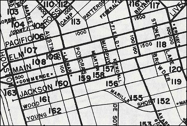
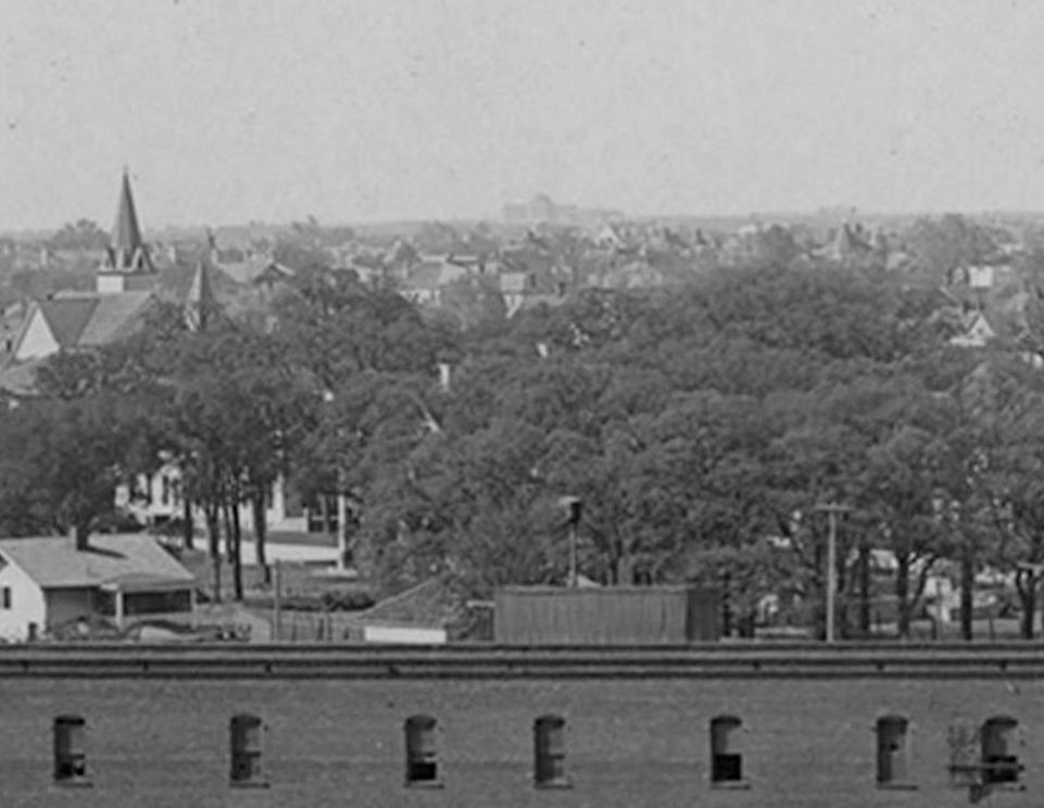
The mayor’s plan for a scenic highway… (click for larger image)

by Paula Bosse

In 1924, Dallas Mayor Louis Blaylock proposed a new route between Dallas and Fort Worth which would closely follow the course of the Trinity River. Not only would this new road relieve congestion of the highway already in heavy use by trucks, business vehicles, and “speeding jitneys,” but it would also provide a more sedate and scenic thoroughfare, intended for use by the citizens of Dallas, Fort Worth, and the mid-cities who enjoyed taking their “pleasure vehicles” out for a stress-free Sunday drive.

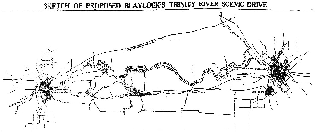
The following text and the above chart appeared in The Dallas Morning News on Nov. 2, 1924:

Sketch of Proposed Blaylock’s Trinity River Scenic Drive

Mayor Louis Blaylock’s proposed scenic highway between Dallas and Fort Worth would follow the course of the West Fork of the Trinity River between the two cities. The above sketch was made in the office of E. A. Kingsley, city engineer of Dallas.

Last week the Dallas Mayor advanced the suggestion that the “necessary new road to Fort Worth” be planned along these lines. Both Mayor Blaylock and Mayor Willard Burton of Fort Worth have offered $5,000 each toward the new enterprise if nine other citizens in both places donate like sums.

Mayor Blaylock said Saturday that such a project would be impracticable without adequate flood control, and when the matter reaches the conference stage around Jan. 1 a system of locks, dams and levees will be discussed. A boat canal between Dallas and Fort Worth and an irrigation system for the intermediate farming country are among the possibilities, said Mayor Blaylock.

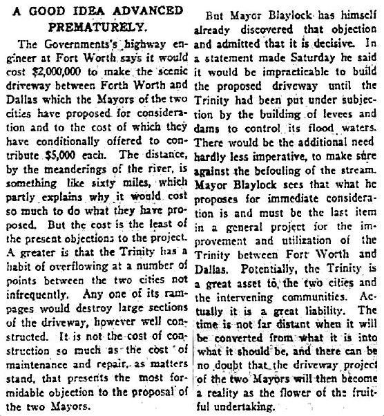
A few days earlier, a sarcastic editorial about the plan (in which the Dallas mayor’s name was misspelled throughout) appeared in The Fort Worth Star-Telegram (click for larger image):

trinity-highway_FWST_102924FWST, Oct. 29, 1924

Even though Dallas and Fort Worth had long engaged in a (mostly) friendly rivalry, it was Fort Worth’s mayor, Willard Burton, who, rather surprisingly, stepped up to offer financial support for the Dallas mayor’s plan. Saying that it was unfair to further burden the taxpayers, he chipped in $5,000 toward the funding of the new road and suggested that he could persuade nine other civic-minded Fort Worthians to do the same. Blaylock may have been forced by mayoral peer pressure to dig deep and follow suit, but he also pledged $5,000 and said he’d get nine flush Dallasites to fork over five thou, too.

trinity-highway_dmn_103124DMN, Oct. 31, 1924

I’m not sure how either thought a 60-mile road could be built between Dallas and Fort Worth for only $100,000 (slightly less than 1.5 million dollars in today’s money). As it turned out, it couldn’t. An engineer with the U.S. Bureau of Roads estimated it would cost closer to $2,000,000 (about 27.5 million dollars in today’s money — a veritable BARGAIN!).

trinity-highway_dmn_110124-costDMN, Nov. 1, 1924

In less than a week of giddy conversations about the Trinity River fantasy boulevard, the plan was pretty much dead when everyone accepted the fact that it was not economically feasible.

trinity-highway_dmn_110424DMN, Nov. 4, 1924

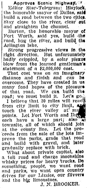
There must have been many sad souls in Dallas in the fall of 1924. But some still insisted it could be built and should be built. Prominent Fort Worth resident J. N. Brooker wrote an impassioned letter to the Star-Telegram, with a few helpful suggestions:

scenic-drive_FWST_112124FWST, Nov. 21, 1924

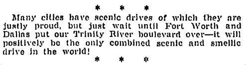
A toll road that charges “moonshine whiskey prices” — there you go!

***

Sources & Notes

Top image from The Dallas Morning News, Nov. 2, 1924 (apologies for the poor resolution!).

More on Mayor Louis Blaylock (1849-1932) from The Handbook of Texas, here.

Lastly, a couple of amusing snide remarks from the pages of Amon Carter’s Fort Worth Star-Telegram:

scenic-drive_FWST_110324FWST, Nov. 3, 1924

scenic-drive_FWST_111124FWST, Nov. 11, 1924

Most images larger when clicked.

*

Copyright © 2015 Paula Bosse. All Rights Reserved.

Post Office, Sunbonnets — ca. 1890s

post-office_hist-photos-of-dallas

“Little Post Office on the Blackland Prairie” (click for larger image)

by Paula Bosse

Laura and Mary Ingalls and Nellie Oleson appear to have wandered into Dallas to take a look at the new Post Office clock tower, seen here at Commerce and Ervay, probably in the mid- to late-1890s.

***

Photo from the book Historic Photos of Dallas by Michael V. Hazel (Nashville: Turner Publishing Co., 2006).

For an incredible view of this same spot from 1894, see my previous post “Henry Stark’s ‘Bird’s Eye of Dallas’ — 1895/96” here (click pictures for larger images).

Click picture for very large image!

*

Copyright © 2015 Paula Bosse. All Rights Reserved.

A Distant Dallas Hall on the Horizon — 1914

dallas-hall_continental-gin_det_1914A clear line of sight, from Deep Ellum to SMU (click for larger image)

by Paula Bosse

A quick “bonus” post: a detail of an incredible photo of the Continental Gin building which shows a ghostly Dallas Hall looming in the distance. Dallas Hall was the first building on the SMU campus, and in 1914 — a year before classes began — the far off building was way, way out in the country. SMU is a little over 5 miles from Deep Ellum. That’s quite a view.

***

This detail is from a photo featured in a previous Flashback Dallas post, “The Continental Gin Complex — 1914,” which can be seen here. I’ve just added this detail — and two other magnified details showing Baylor Hospital and the old Ursuline campus — to the post.

The original photograph, titled “Continental Gin Company on Elm Street, Facing North” by Charles Erwin Arnold, is from the George W. Cook Dallas/Texas Image Collection housed at the DeGolyer Library, Central University Libraries, Southern Methodist University. The photo and its details can be viewed here. It really is one of my favorite historical Dallas photos ever.

*

Copyright © 2015 Paula Bosse. All Rights Reserved.


The Adolphus & Its Annex

adolphus_lang-witchell_arch-yrbk_1922The Adolphus Hotel and its annex, circa 1922 (click for larger image)

by Paula Bosse

Built in 1912, the ornate and luxurious Barnett, Haynes, and Barnett-designed Adolphus Hotel (which was modeled on/inspired by the Plaza Hotel in New York) quickly became THE hotel in Dallas. It was so successful that in only four years an expansion was already underway. The 12-story “Annex” (seen above, just to the left of the original building) was designed by preeminent Dallas architects Otto Lang and Frank Witchell. The so-called “Junior Adolphus” was built around 1916/17 and added 229 rooms to Dallas’ most glamorous hotel. A third addition (“Adolphus III”) came along in the 1920s.

Below, a few views of the Adolphus complex at different stages of its growth. (Click photos for larger images.)

*

adolphus-construction_dallas-then-and-nowBuilt at the northwest corner of Commerce and Akard streets, the Adolphus Hotel was built on the spot previously occupied by the City Hall. This photo, looking northeast, shows the site’s excavation by Vilbig Brothers Construction.

*

1913-pano-2In this detail from an April 1913 panoramic photograph of the city’s skyline, the Adolphus can be seen just six months after its opening at the end of 1912. (A previous post devoted to the full panoramic photo can be accessed here.) The Oriental Hotel, with its rounded topknot, can be seen across Commerce from its sister hotel (both were built by beer king Adolphus Busch). Seen in the background is the Praetorian Building — once the tallest structure in Dallas (it is the tall building, second from the right).

*

adolphus_lang-witchell_arch-yrbk_1922-detThe the Lang & Witchell-designed annex came along around 1916/17 (see top photo). My favorite detail is what looks like an open-air terrace, with tables and chairs, overlooking Commerce Street.

*

adolphus-annex_dallas-hotelsAnother view, showing the hotel and annex in 1924.

*

adolphus-annex_dallas-hotels-detA closer look shows that the terrace is now enclosed.

*

adolphus-hotelA few years later, a further, taller addition was built.

***

Top photo from the 1922 Yearbook of the Dallas Architectural Club.

Photo of the excavation from Dallas Then and Now by Ken Fitzgerald (San Diego: Thunder Bay Press, 2001); photograph from the Texas/Dallas History and Archive Division of the Dallas Public Library. A similar photo can be seen on the fascinating history page of the Vilbig & Associates website, here.

Detail of 1913 panoramic photo from the Jno. J. Johnson photo in the Library of Congress. (For more info, see previous post, “‘New Dallas Skyline’ — 1913,” here.)

Photo of the Adolphus with the Coca Cola sign in the lower left from Historic Dallas Hotels by Sam Childers (Charleston: Arcadia Publishing, 2010). The author’s extremely informative caption can be read here.

See a wonderful pictorial history of the Adolphus Hotel on the Dallas Morning News website here.

The official website for the Adolphus Hotel is here.

Click photos for larger images.

*

Copyright © 2015 Paula Bosse. All Rights Reserved.