Flashback : Dallas

A Miscellany: History, Ads, Pop Culture

Category: Transportation

Braniff DC-3 Over Downtown — 1940

braniff_triple-underpass_imagearchives

by Paula Bosse

Unless there was some sort of photo manipulation involved, that photographer pretty much had just one chance to get that shot. And he got it.

***

Sources & Notes

Photo from Image Archives USA, available for purchase here.

*

Copyright © 2014 Paula Bosse. All Rights Reserved.

Katy Comin’ ‘Round the Bend — 1908

katy-train_mockingbird-greenville_c1908M-K-T approaching…

by Paula Bosse

I love this photo — taken not far from where I grew up — showing an MKT train waaaaaaaaaaaaaaay out in the country. A. C. Greene’s caption, from his book Dallas, The Deciding Years:

The Katy approaches Dallas. This spot would be near Mockingbird Lane and Greenville today. It was taken about 1908.

*

Here’s another photo, circa 1940s — SMU buildings can be seen in the distance.

smu_katy-train_park-cities-walkers-gd_diane-galloway_photo

And the caption to this photo, from the book The Park Cities: A Walker’s Guide and History by Diane Galloway and Kathy Matthews:

SMU as it was in the early forties can be seen in the distance as the Missouri-Kansas-Texas #379 Train No. 2 “Texas Special” speeds by northbound, approaching Greenville Avenue overpass. This particular day the train has a “pusher” because it was over ten cars long.

*

Below, a couple of helpful maps showing the general area (click to see larger images).

katy_greenville_mapsco-19521952 Mapsco

katy-crossing_greenville-ave_googleGoogle Maps

**

I’m just going to imagine the dearly departed Dr Pepper plant in the background. I grew up very close to here, and I would lie awake in bed as a child and hear train whistles a few blocks away. Even though the railroad tracks across Mockingbird, just east of Central, were removed several years ago, I automatically slow down when I drive across where they had been, still expecting to drive over the raised rails.

I sound old. (Am I old?) No, I’m not old! (…Am I?) Hmm. Maybe it’s time to start handing out ribbon candy to the neighborhood children who fetch my hat pins, lye soap, and a bolt of gingham from the sundries counter of the dry goods store in town.

***

Sources & Notes

First photo and caption from Dallas, The Deciding Years by A. C. Greene (Austin: Encino Press, 1973).

Second photo (from the DeGolyer Library, SMU) and caption appeared in the book The Park Cities: A Walker’s Guide and History by Diane Galloway and Kathy Matthews.

*

Copyright © 2014 Paula Bosse. All Rights Reserved.

Industrial Blvd. Congestion — 1952

industrial-blvd_kimball-1954

by Paula Bosse

This photo of Industrial Boulevard is from Our City — Dallas by Justin F. Kimball. Below, a few of his paragraphs on Leslie Stemmons’ vision of what we now know as Industrial Boulevard. (Mr. Stemmons most likely did not foresee the tackiness and bail bonds emporia which now line this “boulevard.”)

Starting at the south end of the levee district, running north the whole length of the district with branches opening to Irving, to Wichita Falls, and to Denton and Gainesville, Industrial Boulevard, 130 feet wide, was dedicated for future traffic use at a time when there was no traffic at all.

One of those present at this stage of the district tells this story: “While the levees were being built and plans being made for the development of the properties, Mr. Stemmons took a group of railroad officials, including Mr. Upthegrove of St. Louis — a Dallas boy, then president of the Cotton Belt Lines — on an inspection tour through the area. There was then no such thing as Industrial Boulevard; Commerce Street west of the river was a narrow road which overflowed whenever the river reached flood stage. The surrounding land was covered with cockleburs, blood weeds and willows. On reaching the site of the present intersection of the Triple Underpass and Industrial Boulevard, Mr. Stemmons remarked, ‘Gentlemen, in twenty years this will be the busiest intersection in Dallas.’ Mr. Upthegrove, an old friend, looked up and said, “Les, you don’t mean that?’ ‘I was never more serious in my life,’ was the reply. Mr. Upthegrove looked around him and shook his head, ‘Gosh,’ he remarked, ‘from cockleburs to congestion.'”

Such is progress! In less than twenty years this intersection was reported to be the busiest intersection of vehicle traffic in the state. Planning, hard work, and faith bring wonders to pass.

***

Photo and text from Justin A. Kimball’s Our City –Dallas; Yesterday and Tomorrow (Dallas: Dallas Independent School District, 1954 — 2nd edition).

More on Leslie A. Stemmons here.

And an article from the months preceding the name-change from Industrial to Riverfront, here.

And if you, like I, wondered if “Mr. Upthegrove” was some sort of contrived Pythonesque name a la “Mr. Smoketoomuch,” it is, apparently, an actual surname. Good to know.

Click photo for larger image.

Need a Studebaker? We Got You Covered

ad_studebaker_1912

by Paula Bosse

Studebaker Bros. have got you covered!

ad_studebaker_souv-gd_1894

Whatever you need, Studebaker has it: horseless carriage or … just … well … carriage.  “A complete line of vehicles.”

***

Top ad from 1912; lower ad from 1894.

Studebaker info here.

*

Copyright © 2014 Paula Bosse. All Rights Reserved.

Lazy Weekends, Cruising White Rock Lake — 1972

white-rock_city-folk_1972_EPACruisin’ ’70s-style…

by Paula Bosse

Back before the days of joggers and bikers, one used to be able to drive around White Rock Lake. All the way around. No dead ends, no detours. People used to cruise it on the weekends — the road would be packed solid. I assume the homeowners grew weary of this and put an end to things by having the road chopped up to prevent continuous cruising. Figures. Here’s a look at one weekend in April of 1972, from a series of photos taken by the Environmental Protection Agency as part of their Documerica project which documented areas of environmental concern. Things all look pretty good here, except for the final photo showing ducks paddling alongside trash at the water’s edge — a scene that might make the Keep America Beautiful Indian shed another tear.

A description of these photos (provided, I think, by the EPA):

City folk come in droves each weekend to once-isolated White Rock Lake. Some come to picnic, sail or fish. Some just want to be where the action is [man].

Another caption:

Once-unspoiled and rather isolated, White Rock has become a city dweller’s weekend mecca, attracting people looking for ‘action’ as much as those seeking relief from urban pressures.

*

white-rock_motorcycle_1972_EPA

white-rock_sunday_1972_EPA

white-rock_weekend_1972_EPA

white-rock_boats-cars_epa_1972

white-rock_sailing_1_1972_EPA

white-rock_sailing_2-1972_EPA

white-rock-lake_1972_EPA

white-rock_ducks_1972_EPA

***

Sources & Notes

These photos — from the EPA’s Documerica project (“to photographically document subjects of environmental concern”) — can be found at the National Archives site, here.

Like outtakes from Dazed and Confused, man…. You can practically hear “Brandy, You’re a Fine Girl” wafting through the air.

Copyright © 2014 Paula Bosse. All Rights Reserved.

Maple North of Wycliff: The Hinterlands — 1900

Looks a little different these days… (click for larger image)

by Paula Bosse

Here we see Maple Avenue, somewhere north of the Katy Railroad crossing, circa 1900. A. C. Greene, in his book Dallas, The Deciding Years, estimated it shows Maple “just north of where Wycliff now crosses” (see note at bottom of post wondering if this might instead show Maple just north of the railroad crossing). I have to say, the present-day view of that area has nothing going for it over the one depicted above, except maybe asphalt. …If you like asphalt.

Here’s a detail that shows the little horse and buggy, heading out to the hinterlands. (Click to see a larger image.)

greene_maple-wycliff-ca1900-det

Personally, I’d take the “hinterlands” view to the one we’re subjected to today.

An interesting book about early Dallas history that I would highly recommend is Diaper Days of Dallas, Ted Dealey’s entertaining memories of growing up in Dallas. His family had a house on Maple Avenue at about the turn of the century (his father was George Bannerman Dealey, early founder of The Dallas Morning News), and the Maple-McKinney area was his playground. Here is his description of the city limits at the time this photo was taken:

Dallas, in those early days, consisted of about eight square miles of territory. To the south the city limits ended roughly at Grand Avenue; to the east the city limits ended roughly where Fitzhugh Avenue now runs; to the north it went out Cedar Springs across Maple Avenue to a point where Melrose Hotel stands now. North of this there was practically nothing. On the west the city extended to the Trinity River.

So, at the turn on the century, this wonderful vista was the hinterlands — out in the country and well beyond the city limits.

***

Photo from Dallas, The Deciding Years by A. C. Greene (Austin: Encino Press, 1973), with the caption: “In 1900 Maple Avenue was mainly a rural lane. This photograph was taken just north of where Wycliff now crosses Maple. Courtesy Dallas Public Library.”

Text quoted is from Diaper Days of Dallas by Ted Dealey (Nashville: Abingdon Press, 1966), p. 23.

EDIT: I don’t know if this photo does show Maple around what is now Wycliff. The curve is very similar to the one Maple used to make before it was straightened in 1918 or 1919 — right around the railroad crossing, which also included a bridge across Turtle Creek, as seen in this detail from a 1905 map. Just a thought.

maple-ave_1905-map_portal_det

Click photos for larger images.

*

Copyright © 2014 Paula Bosse. All Rights Reserved.

The Romance of the Soot-Spewing Locomotive — 1909

t-and-p-flier_1909_LOC

by Paula Bosse

That parasol was white when she left the house.

*

Stereograph card titled “Texas and Pacific Railroad ‘Flier,’ Dallas, Tex.” (1909), from the Library of Congress.

*

Copyright © 2014 Paula Bosse. All Rights Reserved.

Oriental Oil Company: Fill ‘er Up Right There at the Curb

gas-pump_commerce_c1912An Oriental Oil Co. competitor, at 1805 Commerce

by Paula Bosse

I cropped this detail from a much larger view of Commerce Street because this incidental, everyday moment caught my attention. Was that man filling his automobile with gasoline? Was that square, boxy, hip-high thing full of gas, right there at the curb of one of the city’s busiest streets? The sign above the pump reads “PENNSYLVANIA AUTO OIL GASOLINE SUPPLY STATION.” I looked into it, and now I know more about early gas pumps and stations than I ever thought I would.

In the very early days of automobiles, one would have to seek out a supplier of gasoline (such as a hardware store or even a drugstore) where you would buy a gallon or two and carry it home with you in a bucket or something and then carefully pour it into your car’s gas tank using a trusty funnel. After a few years of this inconvenient way to gas up, these curbside pumps began to pop up in larger cities. The pump seen above was at 1805 Commerce St. and belonged to the Pennsylvania Oil Company. It opened in early 1912. That got me to wondering about other such fueling stations, and it seems the first in Dallas may have belonged to the Oriental Oil Company, just down the street from the one seen above, at 1611 Commerce. Here is a fuzzy image of it, from the same, larger photo the detail above was taken from. (Click for larger image.)

oriental-oil_1611-commerce_skyline-det

Could this photo have been taken there? It was listed on eBay merely as “Oriental Oil Company, Dallas, 1910-1920.”

oriental-oil-co_ebay

Oriental Oil’s first “auto station” opened in February, 1911, where “facilities have been arranged so as to fill the cars along the sidewalk.”

oriental-oil_dmn_022611(Dallas Morning News, Feb. 26, 1911)

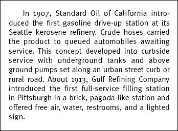
Drive-up “stations” had begun to appear a few years before, on the West Coast.

gas-stations_dot-pdf_p33(Texas Dept. of Transportation, 2003)

In a 1924 Dallas Morning News article (see below), the pump seen in the above photos was described thusly:

Dallas’ first gas filling station had a one-gallon blind pump on the curb which was then thought to be the last word in equipment. Now if a filling station is not equipped with a visible five-gallon pump it is thought to be behind the times and the gas now sold must be water white, when in the old days it was most any color.

This, I think, is what the Oriental and Pennsylvania rolling tanks looked like — the make and model may be different, but I think the general design is the same:

gas-pump-1913

When it was empty, it would be rolled away to be re-filled. I’m not sure about the payment system. Coupon books are mentioned in one of the ads, but I don’t know how (or with whom) one would redeem them as these pumps appear to be self-serve. Perhaps there was a slot for coins/coupons, and everyone worked on the honor system.

It seems that its placement would cause a lot of congestion on a major street like Commerce (which at the time was still shared with skittish horses), but Commerce was also a hotbed of automobile dealerships (Studebaker, Stutz, and Pierce-Arrow dealerships, for example, were within a couple of blocks of the Oriental and Pennsylvania filling stations).

The Oriental Oil Company — a forgotten, early oil company — had an interesting history. The Dallas-based company began business in 1903, starting their company “in a barn in the rear of the Loudermilk undertaking establishment.”

oriental-oil_mercury_123103(Southern-Mercury, Dec. 31, 1903)

They were a fast-growing oil company (“an independent concern which in spite of the strong opposition of the oil trust is now enjoying permanent and growing prosperity”Greater Dallas Illustrated, 1908), and they were one of the first to open a refinery in Texas (they eventually had two refineries in West Dallas). The company’s primary concern in its early years was the manufacture of various oils and greases for industrial use.

oriental-oil-factory-c1908Oriental Oil Company Factory, corner of Corinth St. and Santa Fe tracks, circa 1908

In 1911, understanding just how profitable the new world of retail gasoline sales could be, they installed their first pump at the curb of 1611 Commerce St., near Ervay (“right behind the Owl Drug Store”). A 1924 Dallas Morning News account of the company (see below) states that this was the first gas pump … not only in Dallas … but in the entire state of Texas. I’m not sure if that’s true, but the Smith Brothers who ran Oriental Oil were certainly go-getters — the Smiths were grandsons of Col. B. F. Terry, organizer of the famed Terry’s Texas Rangers, and one of the brothers, Frank, was an early mayor of Highland Park and a three-term president of the Dallas Chamber of Commerce.

ad-1911_oriental-oil_dmn_100811(DMN, Oct. 8, 1911)

ad-1912_oriental-oil_dmn_012812(DMN, Jan. 28, 1912)

Shortly after opening their first pump on Commerce, demand was such that a second pump was soon opened at 211 Lane St. (a mere half a block away!). The DMN reported on Oct. 19, 1911 that a competitor — Consumers’ Oil and Auto Company — was going to be right across the street: “Permission was given to the Consumers’ Oil and Auto Company to place a gasoline tank under the sidewalk at 214 Lane street.” And in March 1912 the Pennsylvania Oil Company was installing ITS underground tank for the pump seen in the photo at the top — again, less than a block away. And in 1916 Oriental opened its splashy new “‘Hurry Back’ Auto Station” right across the street from where that Pennsylvania tank had been. (That Commerce-Ervay area was certainly an early gas station hotbed!)

ad-1916_oriental-oil_dmn_082916(DMN, Aug. 29, 1916)

Newspaper reports also cite claims made by the company that the station mentioned in the ad above — at Commerce and Prather — was the first drive-in gas station in the United States. I’m sure this was good truth-stretching PR for Oriental more than anything, because this claim was not true (Seattle and Pittsburgh seem to be battling each other for that honor). It might not have been the first, but when this “auto station” opened in 1916 (assuming it was “new” as this ad states), it was still pretty early in the history of the drive-in filling station. Also, by 1916, “Hurry Back” had become the company’s slogan as well as the name of its gasoline.

ad-1918_oriental-oil_dmn_102218(DMN, Oct. 22, 1918)

ad-1920_oriental-oil_jewish-monitor_1920(Jewish Monitor, 1920; detail)

ad-oriental-oil_dmn_041121(DMN, Apr. 11, 1921)

oriental-oil_ad_dmn_030522(DMN, Mar. 5, 1922)

I love these ads!

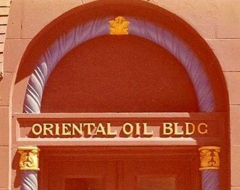
By 1927, the company boasted at least 18 filling stations, two refineries, and branches in Fort Worth and San Antonio. In 1927 they had moved into new offices in the “Oriental Building” at the nexus of Live Oak, St. Paul, and Pacific. A newspaper report described the building as being “finished in Oriental colors with Oriental decorations and is marked at night by very attractive lighting” (DMN, May 1, 1927).

oriental-oil_bldg_1977_flickr

The Oriental Oil Company declared bankruptcy in 1934, selling off their property, refineries, and their name. No more Oroco gas. A lot of companies went bust during the Great Depression, but I’m not sure what precipitated Oriental Oil’s bankruptcy. Actually, I’m surprised by how little information about the Oriental Oil Company I’ve been able to find. Afterall, it and its “Hurry Back” gasoline played a major role in getting the residents of Dallas off their horses and behind the wheel, a major cultural and economic shift that changed the city forever. And it all started at that weird little curbside gas pump on Commerce Street.

***

Sources & Notes

The first two images are details of a photograph by Jno. J. Johnson (“New Skyline from YMCA”), 1912/1913, from the DeGolyer Library, Central University Libraries, Southern Methodist University, viewable here.

Snippet of text from A Field Guide to Gas Stations of Texas by Dwayne Jones (Texas Department of Transportation, 2003).

Illustration of the two 1913 Tokheim portable gas pumps from An Illustrated Guide to Gas Pumps, Identification and Price Guide, 2nd Edition by John H. Sim (Iola, WI: Krause Publications, 2008).

Drawing of the Oriental Oil Company Factory from Greater Dallas Illustrated (Dallas: American Illustrating Co., 1908 — reprinted by Friends of the Dallas Public Library in 1992).

All ads and articles, unless otherwise noted, from The Dallas Morning News.

Color photo of the pink, purple, and gold Oriental Oil Bldg. is a detail from a photo taken around 1977, on Flickr, here.

For an interesting (and mostly accurate) mini-history of the Oriental Oil Company, then in its 20th year of operation, see the Dallas Morning News article “First Dallas Filling Station on Commerce Had One-Gallon Pump” (June 22, 1924).

Some nifty info on early gas stations (yes, really) here.

More info with some really great illustrations and photos here.

Another surprisingly fun and informative article is here.

*

Copyright © 2014 Paula Bosse. All Rights Reserved.

The Katy Komet — 1933

ad-katy-komet_dmn_031733

by Paula Bosse

What a great ad! Next stop, Venus!

***

This Katy Komet overnight freight service ad appeared in the The Dallas Morning News on March 17, 1933.

Click for bigger, BETTER image!

*

Copyright © 2014 Paula Bosse. All Rights Reserved.

Downtown Horse-Trading — ca. 1912

by Paula Bosse

This fantastic photo — taken between about 1912 and 1915 — shows a horse-trading day, taking place around S. Houston and Jackson streets.

Chenoweth’s Feed Store and wagon yard at Houston and Commerce was the scene of monthly trades days or First Mondays from the 1880s into the twentieth century. The crowd spilled over into the streets, blocking passage but no one complained. The old red courthouse survived.

***

Photo from the UT Southwestern Library.

Caption by A. C. Greene from his book Dallas, The Deciding Years (Austin: Encino Press, 1973).

Even though it seems very late to see horses in downtown Dallas, this photo appears to have been taken between 1912 and 1915 when Charles B. Tatum owned a saloon at the corner of Commerce and S. Houston (his sign can be seen painted on the wall facing Houston Street at the left). The MKT Building can be seen at the top right of the photo, indicating that this photo was taken west of S. Houston, almost to Jackson (the old county jail would have been behind the photographer. The same view today can be seen here.

The wagon yard Greene mentions can be seen in the 1905 Sanborn map, here.

Click photo for larger image.

*

Copyright © 2014 Paula Bosse. All Rights Reserved.