
The Bird’s-Eye View of Dallas by Herman Brosius — 1872
by Paula Bosse
 Detail of H. Brosius’ view of Dallas, 1872… (click for larger image)
by Paula Bosse
This lithographed map, drawn by Herman Brosius (1851-1917), shows a bird’s-eye view of Dallas in 1872, when it was teetering on the brink of the explosive growth which came with the arrival of the railroads, and it is one of my favorite maps of the city. Every little detail (including the one above, showing Mrs. Cockrell’s famed Commerce Street toll bridge spanning the Trinity), is cool. I’ve referred to this map when reading about events of this period, and it helps to get an idea of the logistics of the city. (Wikimedia Commons has a really, really large image of this map (7,674 × 5,590 pixels, 11.85 MB!) which can be viewed (and downloaded) here; the file was scanned from a lithograph belonging to The Dallas Historical Society.)

The full view
The drawing was, apparently, pretty accurate (if somewhat idealized). According to a short editorial comment in the Dec. 28, 1872 edition of The Dallas Herald:
[The view by Mr. Brosius] shows every house in the corporation limits, together with every street, so accurately drawn that any one acquainted at all with the city can recognize any building.
Which is pretty amazing. Milwaukee native Brosius (who was only 21 years old when this map was drawn) specialized in these views; after completing one, he (or an agent) would canvass a city seeking “subscribers” in order to gather enough money to print an edition of high-quality lithographs. (An article in a Wisconsin newspaper in 1882 stated that the subscribers for the Eau Claire, Wisconsin view paid $2.50 each, about $60.00 in today’s money.) The Herald editorial exhorted Dallasites to subscribe — not only was Brosius’ work aesthetically pleasing, but “[t]he ‘view’ will be one of the best advertisements that our city could send abroad to induce persons to locate among us.”
The subscribers came through, and I’m pretty sure that most who have pored over this map — as I certainly have — have been delighted and enthralled.
**
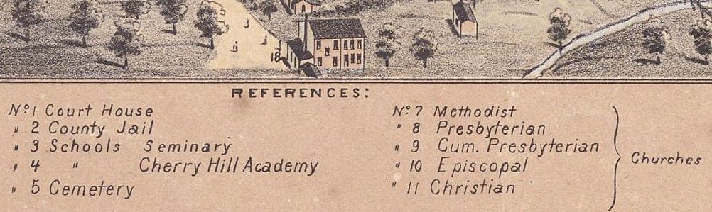
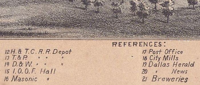
There are helpful references at the bottom of the map which identify buildings.
*


Dallas Herald, Dec. 28, 1872 (click to see larger image)
***
Sources & Notes
“A Bird’s Eye View of the City of Dallas, Texas” (1872) by H. Brosius has been scanned at a very high resolution and is free to view and download at Wikimedia Commons, here (click on the map to see a much larger image). This historic bird’s-eye view is from the collection of The Dallas Historical Society.
The “Bird’s-Eye View of Dallas” article is from The Dallas Herald, Dec. 28, 1872. Read the article as it appeared on the page of the scanned newspaper at UNT’s Portal to Texas History website, here.
Read about Herman Brosius — with more information about his view of Dallas — in an Amon Carter Museum article, here; the museum has a fantastic full site devoted to “Texas Bird’s-Eye Views” — with views of 60 Texas cities (SIXTY!!) — here (click “Browse” at the top of the page).
All images are larger when clicked.
*
Copyright © 2018 Paula Bosse. All Rights Reserved.

[…] at all with the city can recognize any building.” More on this map can be found in the post “The Bird’s-Eye View of Dallas by Herman Brosius — 1872.” (Image source: Dallas Historical Society, via Wikimedia […]
LikeLike
[…] “THE BIRD’S-EYE VIEW OF DALLAS BY HERMAN BROSIUS — 1872” […]
LikeLike
[…] celebrated for their incredible attention to detail. I wrote about this map in a previous post (here), and… yes! The house seen in the photo has been realistically captured in Brosius’ […]
LikeLike