Flashback : Dallas

A Miscellany: History, Ads, Pop Culture

Category: 1900s

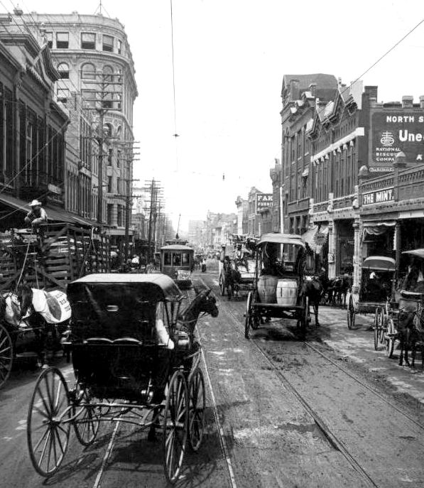
The Nellie Maurine: When a Pleasure Boat Became a Rescue Craft During the Great Trinity River Flood of 1908

nellie-maurine_diaper-daysThe Nellie Maurine

by Paula Bosse

107 years ago today — after days and days of torrential rains — the Trinity River reached a crest of over 52 feet, and the resulting flooding caused loss of life and property and almost incalculable widespread damage on both sides of the suddenly surging river. Bridges and train trestles were washed out, cutting off any way for Dallasites or travelers heading west on trains and interurbans to get from Dallas to Oak Cliff, and vice versa. Ever the home of the entrepreneurial capitalist, the owner of one of the only large boats in the area, the Nellie Maurine, offered his water vehicle to be used as a ferry for those souls desperate to cross the river. For a price.

In September of 1906, E. L. Gale built a large boat in Dallas. It was designed to carry freight as well as passengers on pleasure trips between the “wharf” at the base of Commerce Street and the under-construction Lock and Dam No. 1 at McCommas Bluff. The boat was named after his daughters Vanelle and Maurine.

The Nelle Maurine is a model bow, flat-bottomed boat, seventy feet in length, sixteen-foot beam on the water line, and twenty feet including the guard rail. She is a propeller boat, draws twelve inches of water, and is driven by a 40-horsepower engine. In the event it be found that the engine is not of sufficient power to give the boat the required speed, it is so arranged that it can be changed to 80-horsepower with but very little trouble. With full cargo aboard, the vessel will require a depth of about thirty-three inches of water. (Dallas Morning News, Sept. 29, 1906)

nellie-maurine_dmn_092906DMN, Sept. 29, 1906 (before upper deck/pilot house had been built)

Gale envisioned great success in establishing shipyards and a wharf in Dallas. Though the much hoped-for “navigable Trinity” was still not a reality, many believed a trade route waterway between Dallas and the Gulf of Mexico was inevitable. A person could make a great deal of money by being in on the ground floor of such an industry.

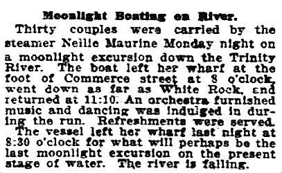
The boat, initially a propeller boat which was converted to a sternwheeler in the summer of 1907, had trouble in operating along the short stretch of river with any kind of regular service — the water level was either too low or too high (when the water was high, the boat could not pass beneath the “Zang boulevard bridge”). The Nellie Maurine was often moored near a large cottonwood tree waiting for the river to cooperate. When it did cooperate, the boat was in demand as a pleasure craft, often offering moonlight treks down the river, complete with onboard dance band. The fare for a daytime round-trip to McCommas Bluff was 50¢; the privately chartered night-time cruises were likely quite a bit higher.

nellie-maurine_dmn_070409-AD
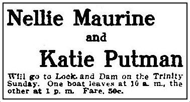
Ad, DMN, July 4, 1909

nellie-maurine_dmn_051308May 13, 1908 (less than two weeks before the flood)

When the Great Flood of 1908 hit on May 25, there was absolute bedlam, beginning in the middle of the night when one man set off several “dynamite bombs” one after another in order to awaken his neighbors who were unaware of the sudden and unexpected rise of the swollen river and who were in imminent danger. When Dallasites went to bed on May 24, the river was at an already high 28 feet. By 3:00 in the morning, just a few short hours later, it had risen to an incredible — and incredibly dangerous — 41.5 feet. By that afternoon it was over 51 feet, and by nightfall, it had surpassed all records and was at more than 52 feet. West Dallas and downtown were underneath water. Homes and livestock were washed away. Electricity was out. Telephones were out. Roads and railways were impassable. There was absolute panic.

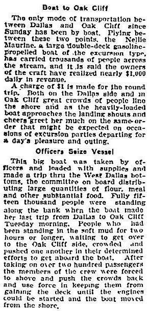
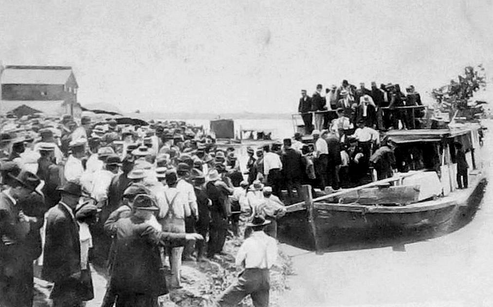
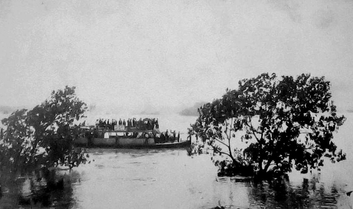
For numerous reasons, people were desperate to cross the river. As all roads and bridges across the Trinity were submerged or destroyed, the only way across was by boat. The Nellie Maurine’s owner saw an opportunity to make a lot of money — by charging people to ferry them back and forth across the Trinity, something that probably rubbed people the wrong way. When city authorities asked permission to use the Nellie Maurine to survey the damage, they were rebuffed when Gale (or his captain) insisted the city pay a fee and the city refused. Dallas County Sheriff Arthur L. Ledbetter and Criminal District Judge W. W. Nelms were having none of that and seized the boat, deputizing the crew and ordering them to set off for the west bank of the river. As it turned out, the damage was far worse than anyone could have expected, and the boat was used to rescue stranded people, some of whom were pulled from treetops. (The account of this survey, titled “West Dallas Trip Proves Thrilling,” is pretty gripping — see link below.)

When the city was done with its search-and-rescue mission, it UN-seized the boat, and the Nellie Maurine began operating as a ferry again, transporting frantic people back and forth across the river. If you wanted to cross the river, you’d have to cough up one dollar — maybe even two, a hefty price to reach safety. (According to the Inflation Calculator, $1 in 1908 would be the equivalent of about $26 in today’s money). It was rumored that this ferry service was generating $1,000 a day (almost $26,000 a day in today’s money!).

nellie-maurine_dmn_052808DMN, May 28, 1908

The Nellie Maurine provided a much-needed service during the Great Dallas Flood — and they also made a substantial profit, which — depending on your business philosophy — is either ingenious or appalling.

*

Below, a few images of the Nellie Maurine. I’m not sure what ultimately became of her, but I have found no mention of the boat past 1910, a year before E. L. Gale died.

First, two photos of the boat taken during the flood (the boat had lost its pilot house when it was caught under the Commerce Street bridge earlier that day). (These two “real photo postcard” images found on eBay.)

flood_nellie-maurine_1908a

flood_nellie-maurine_1908b

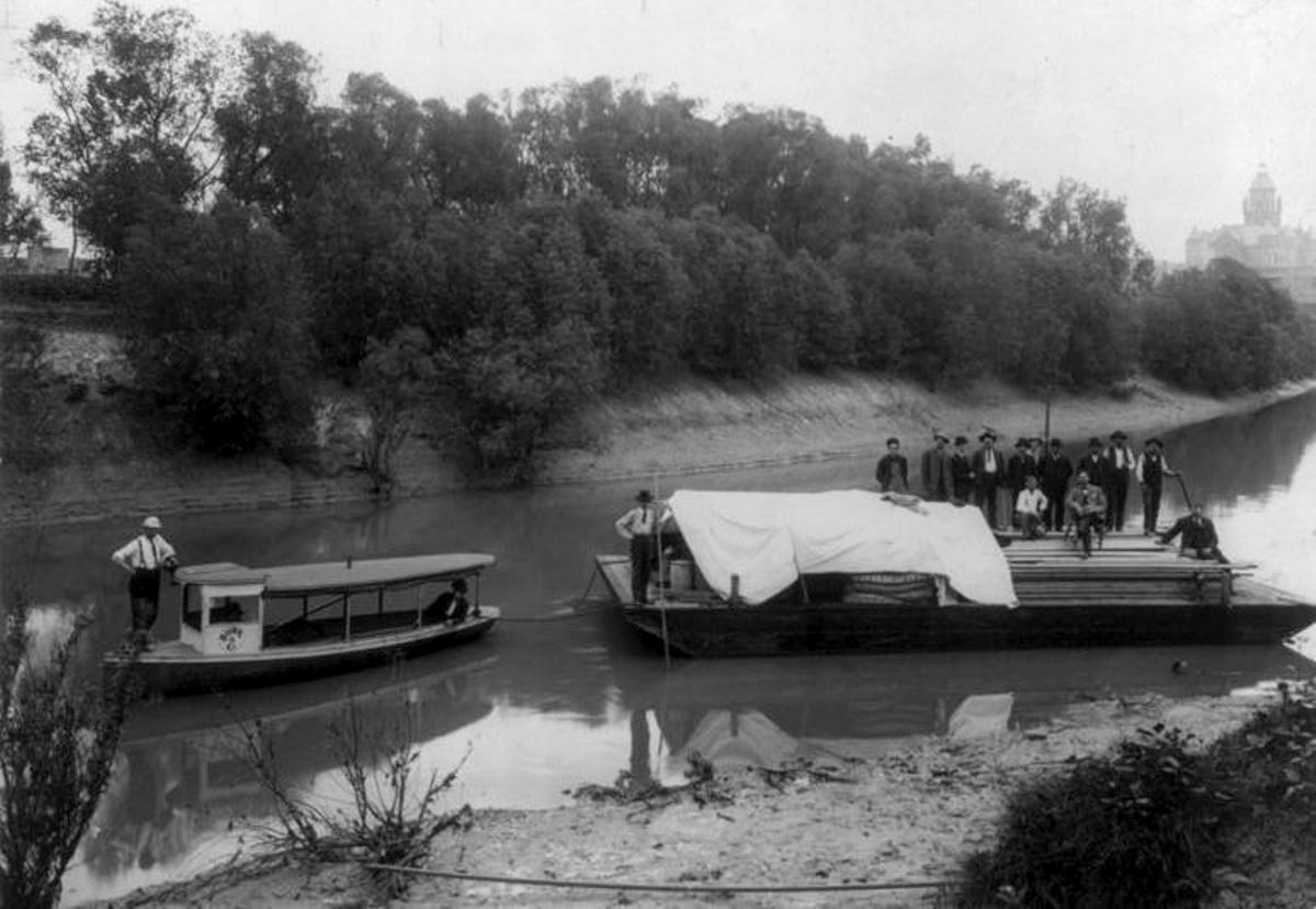
Another photo from 1908 (from the John Miller Morris collection of Texas real photographic postcards and photographs, DeGolyer Library, SMU, here):

nellie-maurine_flood_1908_RPPC_john-miller-morris-collection_de-golyer-lib_SMU_front1908, DeGolyer Library, SMU

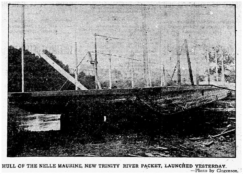
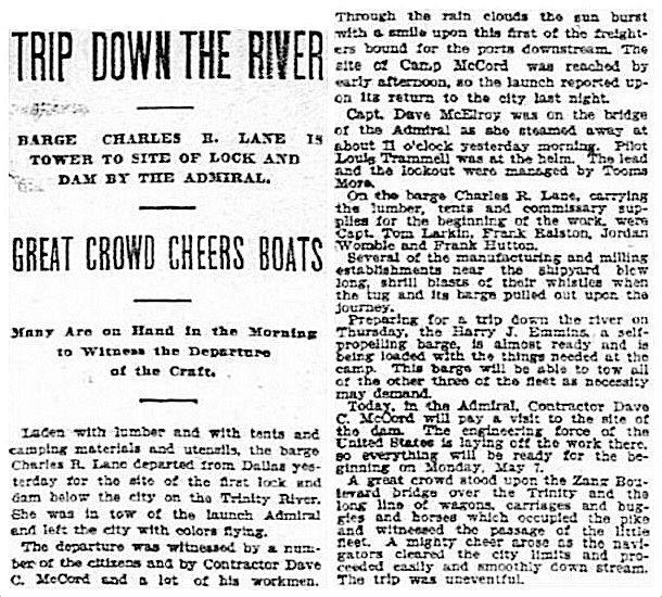
And, lastly, a post-flood photo from 1909, showing builders and contractors onboard, about to head to Lock and Dam No. 1 to check on its progress.

nellie-maurine_dmn_022309DMN, Feb. 23, 1909 (photo by Clogenson)

***

Sources & Notes

Top photo from the highly recommended book Diaper Days of Dallas by Ted Dealey.

Clippings and photos from The Dallas Morning News, as noted.

Read about the introduction of the Nellie Maurine (or the “Nelle Maurine”) to Dallas newspaper readers in an article published in The Dallas Morning News on Sept. 29, 1906, here. (The second photo above accompanied this article.)

Read the account of what was seen from the boat when it was commandeered by city officials in “West Dallas Trip Proves Thrilling,” published in the DMN on May 26, 1908, here.

Read more about the flood in these articles from The Dallas Morning News:

  • “The Trinity’s Swan Song Spree of 1908” by Gene Wallis (DMN, March 1, 1931), a hair-raising account of the havoc wreaked by the flood
  • “Riders Saw 1908 Flood from Ferry” (DMN, May 28, 1957), includes an account of S. S. Cumby, a farm boy who witnessed the flood

The Trinity River flood of 1908 was a story that made national headlines. The death-toll reports were all over the place, from 4 to “hundreds.” I think the official number of lives lost was only 4 or 5, which is pretty amazing, considering the massive destruction caused by the flood. An interesting first-day report can be found in the Wichita (Kansas) Beacon, in a late edition from May 25, 1908, here. “Trinity Is on a Rampage” — indeed.

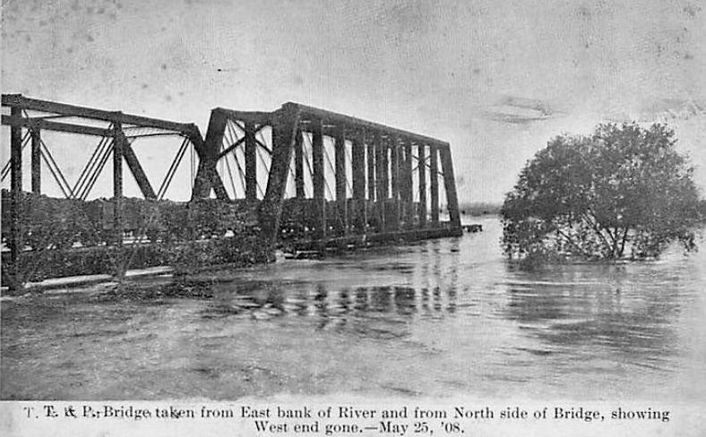
An incredible photo of the washed-out T & P railroad trestle can be found in a previous post here.

Stay dry, y’all!

*

Copyright © 2015 Paula Bosse. All Rights Reserved.

One of the Victims of the Great Trinity Flood: The T & P Railroad Trestle — 1908

flood_t-p-trestle_1908_legacies“T. P. Trestle Before Break, Dallas, Tex.” (click for larger image)

by Paula Bosse

Above and below, photos of the Texas & Pacific railroad trestle spanning the Trinity River, destroyed during the great flood of May, 1908. Five people died in the flooding — in which the Trinity crested at an incredible 52.6 feet — and damage to property was unbelievable. The railroad trestle was just one of numerous victims of the worst flood Dallas has ever known.

flood_t-p-trestle_1908-postcard

***

Photo from the article “After the Deluge: The Impact of the Trinity River Flood of 1908” by Jackie McElhaney (Legacies, Fall, 1999), which you can read here.

Postcard from Flickr, here.

The May 25, 1908 Trinity River flood on Wikipedia, here.

Click pictures for larger images.

*

Copyright © 2015 Paula Bosse. All Rights Reserved.

Barges on the Trinity — 1906

barge_trinity_clogenson_1906-LOC-1A confident crew, a stoic Old Red, and a stubborn river (click for larger image)

by Paula Bosse

“A navigable Trinity.” For over 150 years, people have hoped against hope that the Trinity River might one day be made into a commercial waterway, navigable from the Gulf of Mexico to Dallas. For over a century, federal, state, and local funds were optimistically (misguidedly?) poured into various hopeless plans and projects — but not a one was successful.

In 1906, construction was to begin on one of these projects — a series of locks and dams downriver of Dallas. Above and below are photographs showing the barge Charles R. Lane loaded with lumber and camp provisions, which were to be towed by the launch Admiral to McCommas Bluff, where the first lock was to be built. The above photo ran in the May 1, 1906 edition of The Dallas Morning News above the following caption:

Contractor’s barge, loaded with supplies, about to depart from Dallas for the site of the first lock and dam down the Trinity River.

Below, the story that accompanied the photo. (Click for larger image.)

barge_trinity_dmn_050106DMN, May 1, 1906

barge_trinity_clogenson_1906-LOC-2Dudes and fat-cats, with dollar signs in their eyes (click for larger image)

Later that month, a barge excursion to the site of the future lock was arranged for interested parties. This “merry crowd” of curious looky-loos was towed down the river to McCommas Bluff where they de-barged to tour the site and have a picnic lunch atop the picturesque bluff. They returned to Dallas happy and excited, convinced that maybe — just maybe — the Trinity would finally be tamed!

barge_trinity_dmn_052806DMN, May 28, 1906 (click for larger image)

Giddy enthusiasm about the project was all over the pages of The Dallas Morning News:

The time for doubter and pessimist has passed, and belief in the certainty of the practical navigation of the Trinity now appears unanimous. (DMN, May 2, 1906)

Well-intentioned though this wishful thinking might have been, “certainty” is probably not a word that should be tossed around so lightly. And certainly not in the case of anything having to do with the Trinity.

I bet that poor river just wishes people would leave it alone.

***

Sources & Notes

Both photographs taken by Henry Clogenson; from the collection of the Library of Congress, here and here.

“Trinity River Navigation Projects” entry from the Handbook of Texas is here.

History and photos of the McCommas Bluff Preserve and Trails area (including an interesting photo of Dam #1 from about 1910) can be found on the Dallas Trinity Trails blog, here.

An essential history of the various failed attempts over the years to open up a navigable Trinity between Dallas and the Gulf of Mexico can be found in “Navigating the Trinity: A Dream That Endured for 130 Years” by Jackie McElhaney; the article from the Spring 1991 issue of Legacies can be read here.

An interesting page from the American Canal Society Canal Index — with an illustration of the location of the locks — can be accessed here.

To watch a soothing video shot in the area of the abandoned Dam #1 at beautiful McCommas Bluff, click here.

A related Flashback Dallas post — “Snag Boat Dallas — 1893” — can be found here.

Click pictures for larger images.

*

Copyright © 2015 Paula Bosse. All Rights Reserved.


Iola Bridge

iola-bridge_city-park_ca-1908“Looks like California…” — City Park, ca. 1908

by Paula Bosse

Old postcards of (Old) City Park always seem kind of mysterious to me. I’m fascinated by photos of what was, for many years, Dallas’ only park. It was very big and beautifully landscaped — and it was one of the things about the city that those of earlier generations were most proud of. The postcard views above and below are from the early days of the twentieth century, and, sadly, those views don’t exist anymore — it’s hard to believe they EVER existed here. Even though there’s a hint of what you might see at Reverchon Park, there’s little else about these images that looks like the Dallas of today. What a shame!

But what’s the story behind the attractive little “Iola” bridge? Built in 1905, it was, apparently, Dallas’ first (or possibly second) concrete bridge. The Iola bridge was far sturdier than the wooden bridges around Dallas, and a concrete bridge also required very little upkeep. In fact, this little bridge “of ornamental design” is actually kind of important — it was often cited by city planners and commissioners when discussing the construction of future bridges around the city.

concrete-bridges_dmn_081005Dallas Morning News, Aug. 10, 1905

It seems wooden bridges were being washed away almost as often as Dallas courthouses were burning down. In a letter that appeared in The News on Feb. 21, 1911, it was noted that, while wooden bridges were “under constant repair,” the concrete Iola bridge “has not required one dollar of outlay […] during its six years of existence.” So … cheaper and sturdier. Bye-bye, wooden bridges!

But “Iola”… where did that name come from? I thought it might have been the name of a wife or mother of a mayor or planner, but I suspect it was merely the name of the company that donated the cement for the bridge’s construction, the Iola Portland Cement Company. The company’s canny “civic donation” ultimately paid off BIG for them in the end. Not only did they supply the cement to build that first very pretty little bridge in a very pretty park, they also, ultimately, got whopping new orders from the city for all those new concrete bridges that began to be built — including, less than ten years later (when the Iola company’s West Dallas plant had been sold to the TEXAS Portland Cement Co.), the Trinity River-spanning Oak Cliff/Houston Street viaduct, which, when it opened in 1912, was the longest concrete bridge in the WORLD! And it all began with that unassuming bridge in scenic City Park, just south of the central business district.

*

iola-bridge_watermelon-kid

iola-bridge_dmn_100921aDMN, 1921

Below, a couple of views showing the charming and rather more rustic wooden bridges in the park.

bridge_city-park_watermelon-kid

wooden-bridges_city-park_watermelon-kid

iola-cement_directory-1905Ad from the 1905 Dallas directory

***

Sources & Notes

Top postcard found somewhere on the internet. All other postcards from The Watermelon Kid — here.

Black and white photo by Victor H. Schoffelmayer appeared in The Dallas Morning News on Oct. 9, 1921; it was one of several photographs of the Iola bridge, taken by members of the Dallas Camera Club.

A Dallas Morning News article from July 14, 1905 detailing the new improvements to City Park (including the concrete bridge) can be read here. (I don’t think the really wonderful-sounding “cascade” was ever built — and that’s a pity, because it sounds like it would have been beautiful!)

*

Copyright © 2015 Paula Bosse. All Rights Reserved.

Lively Street Life Outside the Dallas Morning News Building — ca. 1900

dmn-bldg-c1900-degolyer_smuCommerce & Lamar (click for larger image) (DeGolyer Library, SMU)

by Paula Bosse

A photo showing the bustling streets surrounding the newly-expanded Dallas Morning News building, back when it was located at Commerce and Lamar streets. Below, a closer look at turn-of-the-century pedestrian traffic. Click pictures for larger images.

*

dmn-bldg-det1I love the man on the far left … contemplating posting a few illicit bills?

dmn-bldg-det5

dmn-bldg-det2Those curbs!

dmn-bldg-det3Journos.

dmn-bldg-det4A woman either stooped by age or bending over to pick something up, a woman with a carpet bag, and a high-off-the-ground buggy which illustrates one reason those curbs needed to be so high.

***

Photo titled “The Dallas Morning News building, Commerce & Lamar” from the Belo Records 1842-2007 collection, DeGolyer Library, Central University Libraries, Southern Methodist University; it can be viewed here.

Other views of the building from 1900 can be seen in these posts:

  • “Loitering In Front of The Dallas Morning News Building — ca. 1900, here
  • “The Dallas Morning News Building, Inside and Out — ca. 1900,” here

More posts where I’ve zoomed in on historic Dallas photos can be found here.

Click pictures for larger images.

*

Copyright © 2015 Paula Bosse. All Rights Reserved.

The Periphery of the Texas State Fair Never Looked Better

state-fair_postcard_carrie-ednaApproaching the Fair Grounds…

by Paula Bosse

A couple of pretty, but unusual views of the fairgrounds, turn-of-the-century-ish. The message on the postcard at the top: “Carrie the fair was real good this year better than it has been for years. Edna”

And then there’s this view, “Fair Park Scenery.” Same period as the top one? Later? It shows the “Vehicle Exit.” “Vehicles” meaning buggies and wagons?

state-fair-grounds_postcard_vehicle-exitLeaving the Fair Grounds… 

I think the top postcard shows the entrance — I have another view of the entrance that looks like this, from around 1900 (see it here). And the bottom card? “Scenery” near the Vehicle Exit. So … a parking lot? Or a road leading to the exit? Whatever it is, it’s not really all that “scenic.” Both postcards are fairly odd choices for picture postcards of the Texas State Fair, as neither one shows anything of the actual fair! But if people had fond memories of driving into or out of the State Fair, these were the postcards to buy!

***

Sources & Notes

Postcards from eBay. The second one is a photo by Clogenson.

Top postcard’s 2-cent stamp was issued in Nov. 1903, per Wikipedia.

*

Copyright © 2015 Paula Bosse. All Rights Reserved.

The Interurban Parlor Car: Perusing the News in Comfy Chairs

interurban-interior_tx-historian_jan81(Click for larger image)

by Paula Bosse

The height of comfort!

You know this photo was taken for promotional purposes, because none of the men has a reeking cigar clenched between his teeth.

***

Texas Electric Railway Interurban ad reprinted in Texas Historian, Jan. 1981.

Interurbans were great. I wish we still had them. Read about what they were, here.

*

Copyright © 2015 Paula Bosse. All Rights Reserved.

Winter Scene: The Belo Mansion & The Cathedral of the Sacred Heart — ca. 1902

cathedral_snow_flickr-colteraSnow on Ross Avenue…

by Paula Bosse

A beautiful dusting of snow in one of the tonier areas of the city, captured by a postcard photographer in the early years of the 20th century — back when the snowy slush along Ross Avenue would have been caused by horses and the buggies they pulled behind them.

The date of this postcard is unknown, but at the end of 1902 (the same year the construction of the cathedral was completed) it snowed in Dallas — a “weather event” then (as now) so out of the ordinary that it resulted in these rapturous few paragraphs from the December 4, 1902 edition of The Dallas Morning News:

snow_dmn_120402DMN, Dec. 4, 1902

***

Sources & Notes

Postcard from Flickr, here.

The Belo Mansion was built in about 1890; more info here.

Construction of the Cathedral of the Sacred Heart (now the Cathedral Santuario de Guadalupe) was completed in 1902. Except for the bell tower, which, though part of the architect Nicholas J. Clayton’s original design, was not completed until 2005. More on this “sympathetic addition” from Architexas, here.

While most of the buildings and houses that once stood along ritzy Ross Avenue are long gone, both the Cathedral and the Belo Mansion still stand as Ross Avenue landmarks.

Below, the same view today (sans snow), via Google Street View (click for larger image). I really wish that iron fence was still there.

belo-cathedral_google

*

Copyright © 2015 Paula Bosse. All Rights Reserved.

“Everyday Life” on Elm Street — ca. 1905

elm-street_everyday-life_UCR-smallElm Street rush hour

by Paula Bosse

Automobiles would be rolling down Elm Street very soon, but even when the traffic was still mostly horse-related, there’s a lot going on here: horses, buggies, barrels, saloons, a bored kid on a wagon, a street car, and the Wilson Building.

elm-st_everyday-life_UCR-det

elm-st_everyday-life_UCR-zoom(click for larger images)

And what was The Mint? The Mint was a saloon. I’m not sure when it first set up shop in Dallas, but it was listed in an 1877 directory, one of the city’s earliest.

elm-st_everyday-life_mint_UCR

Speaking of 1877, read about a typical frontier day at The Mint in two accounts of a stabbing, from The Dallas Herald in April, 1877, here, and the follow-up, here.

***

Sources & Notes

Photo is from a stereograph titled “Everyday Life, Elm Street, Dallas, Tex.” from the Keystone-Mast Collection, UCR/California Museum of Photography, University of California at Riverside; it can be accessed here.

Images larger when clicked.

*

Copyright © 2015 Paula Bosse. All Rights Reserved.

Views From a Passing Train — 1902

edmunds_pacific-bryan_free-lib-phil_1902Pacific, looking west toward Bryan, 1902 (click for larger image)

by Paula Bosse

Franklin Davenport Edmunds (1874-1948) was a Philadelphia architect whose hobbies were travel and photography. A 1902 train trip to Mexico took him through Texas, during which there as a blink-and-you’ll-miss-it stop in Dallas.

edmunds_whos-who-philadelphia_1920Who’s Who in Philadelphia, 1920

On the way to Mexico, he stopped in St. Louis for a while (where he took several photos on Feb. 12), passed through Arkansas (on Feb. 13), apparently saw very little of Dallas as he rolled through, and then took a lot of photos when he reached San Antonio (by Feb. 14). He then continued on to a vacation of at least two or three weeks in Mexico, where his camera was never far from his side.

The two photos that were taken as he passed through Dallas (which I’m assuming were snapped from the train) were probably taken on Feb. 13 or 14, 1902.

The location of the photo above is not noted, but it appears to be Pacific Avenue looking west. Peter S. Borich’s sign-painting business was on the northeast “corner” of Bryan and Pacific (at the point of the diagonal intersection). The photo shows the back and side of his building. It’s hard to see them, but there is a wagon with a team of horses at the Bryan St. intersection. Behind Borich’s is a blacksmith shop, and across the street, there are several furniture stores. Straight ahead is an almost mirage-like smoke-spewing locomotive heading toward the camera. (Unless Edmunds was standing in the middle of Pacific, I’m guessing he was taking the photo from the rear of the train.)

Seconds later, the train would have pulled into the old Union Depot (located about where Pacific would cross present-day Central Expressway).

edmunds_old-union-stn_free-lib-phil_1902(click for larger image)

Even though not identified in the photo description, the distinctive old Union Depot is instantly recognizable (an unrelated photo taken from about the same spot can be seen in this one from the George W. Cook collection at SMU’s DeGolyer Library). Again, the photo appears to have been taken from the train.

Edmunds took a ton of photos on this trip, but, sadly, he seems to have merely passed through Dallas without wandering around to explore its streets (which I would think would be interesting — if not downright exotic — to a Philadelphia architect) — I’m not sure he even got off the train to stretch his legs! But I’ve never seen these two photos, and they’re pretty cool. So, thanks, Frank — you should have hung around a little longer.

***

Both photos by Franklin Davenport Edmunds are from the Free Library of Philadelphia. The Pacific Avenue photo can be accessed here; the Union Depot photo, here. Other photos he took in Texas during the 1902 trip (and a few from a previous 1899 trip) can be viewed here.

A biography of Edmunds can be read at PhiladelphiaBuildings.org here.

A detail from the 1905 Sanborn map showing the businesses located at Pacific and Bryan, with Borich’s business circled in red and the camera’s vantage point in blue, can be seen here.

Below, a detail from a map (circa 1890-1900), showing the locations of the two photos, with the Pacific Ave. location circled in green and the Union Depot location in yellow.

dallas-map_ca1900(click for larger image)

And, lastly, a present-day image showing the same view as the top photo (from Google Street View).

pacific-bryan_google

My previous post, “The Old Union Depot in East Dallas: 1897-1935” — a history of the station with several photos — can be found here.

Images larger when clicked.

*

Copyright © 2015 Paula Bosse. All Rights Reserved.