Flashback : Dallas

A Miscellany: History, Ads, Pop Culture

Category: Architecture/Significant Bldgs.

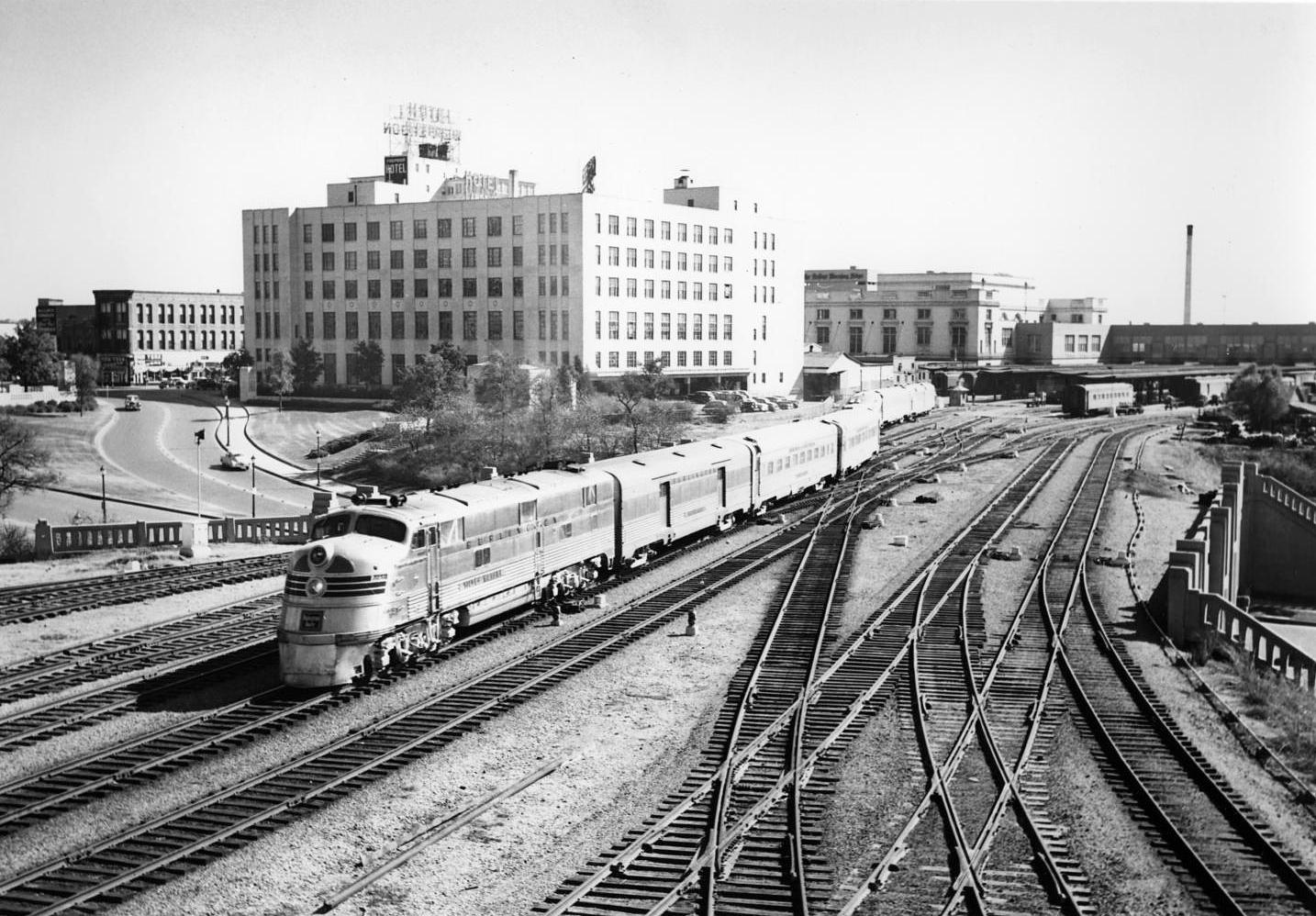
The Sam Houston Zephyr Leaving Union Station, Crossing Over the Triple Underpass — 1950

zephyr_triple-underpass_1950_portalThe SHZ heading out of Dallas… (click for larger image)

by Paula Bosse

The title pretty much says it all. The Sam Houston Zephyr passenger train is seen crossing over the Triple Underpass, heading out of Dallas. Next stop: Fort Worth. The Post Office Terminal Annex is the tall white building, the Jefferson Hotel is behind it (with the sign on its roof), and Union Station is in the background, just right of center, with the Dallas Morning News building peeking over its roofline. The Old Red Courthouse would be out of frame to the left.

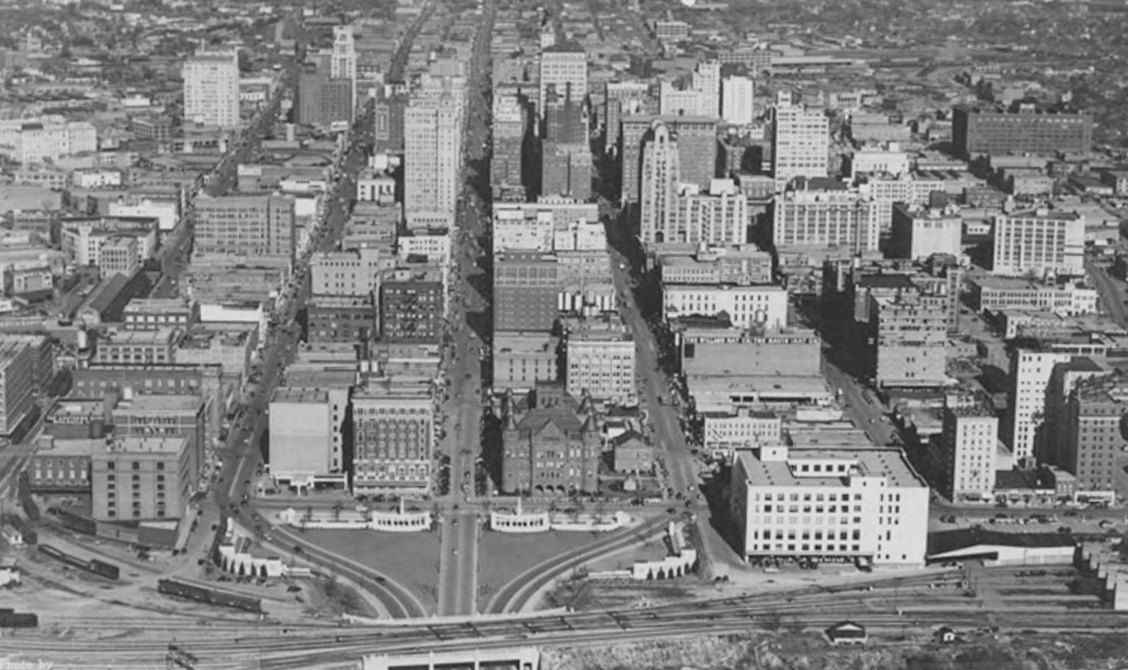
Below, a view of downtown from the west, with the Triple Underpass partially cut off at the very bottom, and Union Station just out of frame at the right.

downtown_aerial-photo-service_postcard_cook-collection_smu_cropped

In asking members of Facebook’s Texas Railroad History group about the top photo, Gerald Preas, one of the members, made this comment, full of interesting little tidbits (slightly edited by me):

The large building in the center is the USPO Terminal Annex. I started working there in August 1963. The buildings between TA and Union Station were part of Railway Express, used for sorting mail to and from RPO cars. That stack in back was the power station for Union Station — it had its own electric and water system, maybe sewage, too. I drank many times that cool sweet well-water. Notice cars around TA loading dock. I supervised that dock 1968/69 — we had to keep the area open. Now look where train is bending, people would park off ballast, but cars turning would swing out further and hit parked cars. That tree on the upper right led down grade to vacant parting lot. I was coming up that path when the President was shot.

***

Sources & Notes

Top photo shows the Fort Worth and Denver’s Sam Houston Zephyr train No. 4, northbound from Houston, leaving the Dallas Union Terminal Station, heading to Fort Worth. The photo was taken by Roger S. Plummer in 1950; photo from the Museum of the American Railroad, via UNT’s Portal to Texas History, here.

(Other photos of the Sam Houston Zephyr taken in Dallas — and one in Fort Worth — by Roger S. Plummer between 1949 and 1955 can be found on the Portal to Texas History site, here.)

Bottom image titled simply “Dallas, Texas” is an Aerial Photo Service postcard, from the George W. Cook Dallas/Texas Image Collection, DeGolyer Library, Central University Libraries, Southern Methodist University. I’ve edited the image a bit — see the original image and description here.

An aerial view of the same area today can be seen here, via Google.

A previous Flashback Dallas post on the stunningly beautiful Texas Zephyr can be found here.

Thanks to the members of the Texas Railroad History group on Facebook for their comments and help.

Both photos are larger when clicked.

*

Copyright © 2016 Paula Bosse. All Rights Reserved.


The Expanded “Texas Size” Titche’s Building: Twelve Glamorous Acres of Department Store — 1955

titches_utaDallas’ largest department store, ca. 1955…

by Paula Bosse

This photo of the Titche-Goettinger department store (Main and St. Paul) was taken soon after the store’s expansion which increased its size from 250,000 square feet to a whopping 504,000 square feet. When the greatly enlarged store introduced itself to the Dallas public at an open house in March 1955, one of the most notable things about it (for me, anyway) was the fact that 93-year-old Max Goettinger — founder of the department store in 1902, along with Edward Titche — attended the festivities.

The beautiful original building — designed by George Dahl — was built in the late 1920s and was a commanding presence at only half its later size. (Click pictures to see larger images.)

titches_night

The postcard view above has handily erased most of the other buildings in that block which one would have seen in a photograph, including the Pollock Trunk Co. and the old Hilton Hotel (later the White Plaza, currently the Indigo). A 1942 view of the block, looking west from Harwood, looked like this:

main-street-canyon_ebay

When construction of the new part of the store was completed in 1955, this new 12-acre “Texas Size” Titche’s was the largest store in Dallas, a head-spinning prospect for a city that loves to shop.

**

If you want a much more comprehensive overview of the Titche’s building — and want to see wonderful photos of the building, inside and out — I highly recommend Noah Jeppson’s Unvisited Dallas post, “Titche-Goettinger Building,” here. My favorite part? Its innovative system of pneumatic tubes!

***

Sources & Notes

Top photo by Squire Haskins, from the Squire Haskins Photography, Inc. Collection, UTA Libraries, Special Collections — more info here) (click on the thumbnail image on the page to see this photo BIG).

Read more on the expansion at the Dallas Morning News archives:

  • “Titche’s Reports Plans to Double Present Size” by Edd Rout (DMN, Sept. 7, 1952)
  • “Visitors Jam Opening of Texas-Sized Titche’s” by James A. Cockrell (DMN, March 15, 1955)

This wonderful building is still standing, modified to accommodate its current owners, the University of North Texas. Here’s how the building looks these days, via Google Street View, here.

More on the Titche-Goettinger Building on Wikipedia, here.

*

Copyright © 2016 Paula Bosse. All Rights Reserved.

Next-Door Neighbors: The Palace Theater and Lone Star Seed & Floral — 1926

palace-theatre_melting-pot_march-1926_utaElm Street neighbors, March, 1926…. (click for larger image)

by Paula Bosse

Above, the Palace Theater, one of Dallas’ great moviehouses. It opened in June, 1921, near the northwest corner of Elm and Ervay; this photograph is from March of 1926, three months before the theater’s fifth birthday. It was still a whippersnapper. 

Below, a detail from the photo: by zooming in and tweaking the contrast, the box office is revealed, as are two women chatting in the shadows (all pictures and clippings are larger when clicked).

palace-theatre_melting-pot_march-1926_uta_det2

As interesting as old movie theaters are, I was more intrigued by the three people to the right of the theater (who all look like characters from a period melodrama) and by the business next door. I’ll never know who those men were or who that woman was waiting for, but finding out what business was selling baby chicks (…next door to the Palace?) was pretty easy.

palace_lone-star-seed_1926_uta_det

The store was Lone Star Seed & Floral (1627 Elm). They sold seeds and flowers, potted plants, canaries, goldfish, and pet and livestock supplies. They could also help you with all your poultry needs: feed, incubators, medicine, and live chickens. …Right next door to one of the plushest and most luxurious entertainment destinations in Dallas.

Lone Star Seed & Floral appears to have once been Texas Seed & Floral and had been around since at least 1892. They set up shop at 1627 Elm in 1902 and remained there quite a while until they moved in January, 1927, just a few months after the top photo was taken. Here is a postcard of its earlier incarnation, with photos of the Pacific Avenue location at the left, and the Elm Street location at the lower right (the view is looking north on Ervay; the Palace would later be built immediately west of this  building, to the left of the lower postcard image, just out of frame).

texas-seed-and-floral_1908_portal

The store looks very clean and extremely well organized. My inexplicable love of things stored in card-catalog-file-like cabinets and fold-out bins tells me I’d probably be stopping in fairly regularly after having seen the latest Buster Keaton film next door.

lone-star-seed_the-seed-world_082020

lone-star-seed_the-seed-world_082020_article
Photo and article from, yes, The Seed World, Aug. 20, 1920

lone-star-seed_dmn_022622
Feb., 1922

But back to the Palace. The banner is publicizing the imminent arrival of John Murray Anderson’s “The Melting Pot,” a stage production which opened at the Palace on March 14, 1926. The Palace Theater, owned by the Publix chain, was about to embark on “a new and surprisingly different type of entertainment,” which consisted of musical revue roadshows staged in New York under the direction of producer John Murray Anderson. Each production — its performers, costumes, and sets — would be sent into the hinterlands, playing a circuit which included Dallas, the only stop in Texas. There was a new show every week. And if you missed it, you really had no excuse: there were four shows daily (five on Sunday). (Anderson was later asked by Billy Rose to help with producing Fort Worth’s Centennial celebration.) (John Rosenfield’s tepidly positive Dallas Morning News review, “‘Melting Pot’ Is Presented at Palace, Introducing New Style Film Theater Feature,” ran on March 15, 1926.)

palace_dmn_031326_melting-pot-ad
Palace ad, March 13, 1926

*

palace-theatre_1926_uta_det1

***

Sources & Notes

Top photo from the Billy Burke Photograph Collection, UTA Libraries, Special Collections; more info here.

See the same view today via Google Street View here.

The Texas Seed & Floral Co. postcard is from the collection of Dallas Heritage Village, via the Portal to Texas History, here.

The beloved Palace — once an honest-to-God “movie palace” was unceremoniously demolished in 1971. It had stood at Elm and Ervay for 50 years. The north side of that block is now occupied by Thanksgiving Tower. The theater and the seed store were just west of Ervay — Lone Star Seed & Floral was just to the left of where the 7-Eleven is, on the ground floor of 211 N. Ervay, the blue building seen here (the view is northwesterly from the Wilson Building across the street).

See a great photo of Elm Street in the ’20s in the post “Dazzling Neon, Theater Row — 1929” here.

Click pictures and clipping to see larger images.

*

Copyright © 2016 Paula Bosse. All Rights Reserved.


The Katy Building, Commerce Street

m-k-t_katy-bldg_flickr_coltera“The Katy Serves the Southwest…” (click for larger image)

by Paula Bosse

A couple of days ago I posted a photo of an M-K-T train leaving Dallas and, today, coincidentally, I came across a photo of the Katy Building, the railroad’s headquarters, at Commerce and Market. This photo shows Commerce looking west toward the Old Red Courthouse from Austin Street. An interurban car is heading east.

See the same view today, via Google Street View, here.

A photo I really love — which shows a view from about the same time looking east on Commerce — can be seen in a previous post, “Commerce & Record Streets — 1946,” here.

***

Photo from Flickr, here.

*

Copyright © 2016 Paula Bosse. All Rights Reserved.

The Business District at Night

skyline_night_flickr_coltera

by Paula Bosse

If you squint, the Mercantile Building looks a little Statue-of-Liberty here.

***

Postcard from Flickr.

Click for larger view.

*

Copyright © 2016 Paula Bosse. All Rights Reserved.

50 Years Before Main Street Garden Park

skillerns_statler-hilton_ebayHey, Skillern’s, you’re blocking the view!

by Paula Bosse

This view showing a Skillern’s drugstore at the southwest corner of Main and Harwood was taken as the Statler Hilton was nearing its opening in 1956. The block bounded by Main, Harwood, Commerce, and St. Paul was filled with businesses (…and later a parking garage) (…and way before that, homes) has been cleared and is now the lovely Main Street Garden Park. It’s always nice to have green space downtown, but, for me, the absolute best thing about this open space is that it FINALLY allows the beauty of the old (soon-to-be-new again) Statler Hilton, the old Titche-Goettinger building, and the old Municipal Building to be seen as they should have been seen all along: in full view, from a distance, without anything impeding the view. And now … the 360°-view — especially at night — is spectacular! Below, that same block these days, captured in a fantastic photo by my favorite Dallas photographer, Justin Terveen.

statler-hilton_justin-terveenJustin Terveen

As much as I love the mid-century skyline of this city, I have to say, the 21st-century version of this end of downtown — this square — wins.

***

Sources & Notes

The top photo appeared a couple of months ago on eBay.

The color photo is by Dallas photographer Justin Terveen, used with permission. See more of Justin’s incredible photos here — the one above and many others are available for purchase. I tend to get stuck in the past, but seeing Justin’s photographs of present-day Dallas make me realize how remarkably modern and vibrant the city is right now.

The same view from Main and Harwood, as seen today on Google, is here.

It always felt a little claustrophobic on Main, Harwood, and Commerce — those buildings needed room to breathe. For years, that block in the middle got in the way of fully appreciating Titche’s (this idealized postcard view shows Main Street at the right, St. Paul at the left), the Statler Hilton, and the Municipal Building (this 1920s photo shows people standing on the steps with a former drugstore occupant — Drake’s — across Harwood; Harwood was especially narrow when the building was originally built in 1914, and, as I recall, many were unhappy that such a majestic building was built in a location where it was impossible to fully appreciate its aesthetic qualities, even after the street was widened several years later).

More on Main Street Garden Park is here and here.

*

Copyright © 2016 Paula Bosse. All Rights Reserved.

Three Flags Over Texas at the Entrance to Fair Park — 1936

tx-centennial_flags_entrance_nyplMexico, France, and Texas welcome visitors…

by Paula Bosse

Another State Fair of Texas is winding down. Here’s what the entrance to Fair Park looked like when the Texas Centennial opened in June 1936. This Associated Press photo was accompanied by the following caption when it ran in newspapers:

FLAGS  WAVE  AT  TEXAS  CENTENNIAL
Dallas, June 6 — Three of six flags which have flown over the Lone Star State, waved over the main entrance to the Texas Centennial celebration at its opening here today. Buildings throughout the grounds of the exposition are ultra modern in design.

This view — taken at about Parry and Exposition — hasn’t changed all that much. See it on Google Street View here.

***

Sources & Notes

Associated Press photo from the New York Public Library’s digital collections, here.

*

Copyright © 2016 Paula Bosse. All Rights Reserved.

Empire Central and Its Fabulous Empire Club

empire-central_1958_ebay_det“Northwest Dallas” in 1959 — how quaint… (click for larger image)

by Paula Bosse

“Empire Central.”

I have to admit that I’d never heard of anyplace in Dallas called Empire Central, but because I wanted to post the picture above (which I love) (and which is  from a 1959 ad), I felt I should at least look into finding out what and where it was and broaden my horizons a bit. So I did. It was (is?) an “office community” built in 1958 on 90 acres of land (later expanded), located in the “V” between Hwy. 77 (soon to be Stemmons Freeway) and Hwy. 183 (aka Empire Freeway, soon to be John W. Carpenter Freeway), with W. Mockingbird on the south and Dividend Drive on the north(-ish). It was developed as an office park as part of the already existing 1,200-acre Brook Hollow Industrial District (which, when its development began in 1953, was beyond the city limits) — both areas were developed by Windsor Properties. Empire Central was announced in 1957.

Unsurprisingly, almost every early newspaper story about plans for the new district mentioned what was considered to be its sexiest, most novel attraction: the Empire Club, an on-site dining and recreation club for employees — executives and underlings alike — who worked in the “community’s” office buildings. It was a round, 45,000-square-foot structure that sat on 9 acres and featured a distinctive roof which utilized 24 tamarack logs “more than 100 feet long, imported here especially for the club from the virgin forests of Washington” (DMN, Nov. 24, 1957). Its amenities included a sunken garden, a terraced dining room, lounge, swimming pool, putting green, and shuffleboard court, all nestled in a “garden-like atmosphere.” What a great perk!

The club was important in the conceptualization of the office park, as the developers insisted that a happy employee was a productive employee, as can be seen in the text from a 1959 advertisement which ran the week the club opened:

Two fundamental concepts were taken into consideration by Windsor Properties, Inc., in designing Empire Central.

First was the realization that the company able to attract the most capable employees at a given wage would be most successful. Second, the urbanization of our population has created the need for a measure of community life.

The Empire Club, as the heart of Empire Central, is designed to accomplish both objectives for management.

And that club looked cool. It was a cutting-edge design from the always impressive George Dahl, one of Dallas’ top architects. (Dahl worked on several other projects with W. C. Windsor — Sr. and Jr. — including a prison (?!) and several other buildings in the Empire Central District.) Dahl’s previous big round building — Memorial Auditorium/Dallas Convention Center — had opened in 1957, just months before construction began on this unusual and sophisticated clubhouse, something one would certainly not expect to find plonked down in the middle of such prosaic surroundings.

empire-central_dmn_101859_empire-club_det

empire-central_dmn_101859_empire-club_pool_det

empire-central_dmn_101859_map_det

Below, the full ad, which appeared the week the new Empire Club opened in October, 1959 (click to see larger image):

empire-central_dmn_101859_empire-club
Oct., 1959

At some point (or maybe always) the club began to be used by outside groups. In the ’60s, it was the site of a lot of Junior League and debutante activities and dances. In 1966 the Empire Club became The Round House restaurant (in which could be found the Fatted Calf club). The last listing I could find of a restaurant or club at that address (which was, originally, 100 Empire Central Drive and, later, 1100 Empire Central Place) was in 1971. Sadly, that cool-looking building was torn down somewhere along the way. What a shame! I just discover a George Dahl-designed building I’d never seen — in a part of town I’d never heard of — and *poof*! … it’s gone. …At least I didn’t have time to get too attached.

**

Here’s a great photo from 1960 (click it — it’s really big) looking southeast toward downtown from about Regal Row (bridge in foreground), with the new and improved Carpenter Freeway/Hwy. 183 in the center, and Stemmons — coming in from the left — meeting it in the distance; the Mockingbird bridge is just beyond it, just above the point. The Empire Central district — in between Stemmons and Carpenter — looks kind of puny here. You  might have to squint, but you can see the brown, round Empire Club building in the center of the triangle. If you listen closely, you might be able to hear a Southwestern Drug Company secretary splashing happily in the heated pool.

empire-central_183-construction_1960_dallas-freeways-site

*

empire-central_1958_ebay
1958 ad

empire-central_dmn_011958_ad
Jan., 1958

empire-central_google
Google Maps

***

Sources & Notes

Top image is from a full-page magazine ad from 1958, found on eBay.

The 1960 photo appeared on the cover of Dallas magazine (October, 1960); I found it on the unbelievably thorough Dallas-Fort Worth Freeways site (main page is here, this photo is linked from here).

This area — what is it called? The consensus seems to be “Brook Hollow.” Or maybe “Stemmons Corridor” (the Wikipedia entry for the latter is here).

The Flashback Dallas post on the area’s 1920s-era namesake golf club — “Brook Hollow Country Club — 1940s” — is here.

(Thank you, Dallas History Facebook group for the helpful tidbits!)

Think it should be bigger? Click it!

*

Copyright © 2016 Paula Bosse. All Rights Reserved.


Marvin’s Drug Store, Main and Akard

akard-looking-north_colteraLooking north up Akard from Main… (click for larger image)

by Paula Bosse

This postcard shows a bustling downtown at the intersection of Main and Akard (the view straight ahead is North Akard). Marvin’s Drug Store, on the northwest corner, was at 1415 Main, and the Palace Drug Store, on the southwest corner, was at 1414 Main. The Palace Drug Store moved to this location in December of 1909, and I’d guess the original photo used here was taken around 1910. See what this view looks like today here.

I love colorized postcards from this period, but sometimes draining them of their color gives a more realistic view of the scene (but doing this can also add a weird surreal flavor when you begin to notice evidence of the artist’s heavy hand — check out the two creepy Edvard Munch-like blank-faced pedestrians at the far right). (Click for larger image.)

akard-looking-north_coltera_bw

The building housing Marvin’s Drug Store was originally known as the Rowan Building, seen below in 1899 — its distinctive cupola was unceremoniously cropped from the postcard view.

rowan-bldg_1889-photo_detail_natl-city-bank-ny-ad_1939

In this photo you can see “Rowan” on the cupola:

rowan-bldg_marvins-drug-store_ebay

This attractive building was torn down in order to build the taller Marvin Building, which was originally intended to be 24 stories but was later downgraded to 16 stories, then to 10, then to 4 (but with plans to add more at a later date). When the new building opened in 1927, the namesake drugstore was retained as its ground-floor anchor tenant. This new structure was known as the Marvin Building until 1931 when the Gulf States Life Insurance Company purchased it and it became known as the Gulf States Building (coincidentally, ol’ Z. E. “Zeke” Marvin not only owned the Marvin Building and the Marvin Drug Company, but he was also the former president and CEO of the Gulf States Insurance Company). A Lang & Witchell-designed six-story addition was built in 1935. This 16-story building is still  standing and has been converted into residential loft space.

gulf-states-bldg_chamberlin-site

***

Sources & Notes

The postcard at the top is from the incredible Flickr collection of Christian Spencer Anderson (aka “Coltera”), here.

The 1899 photo of the Rowan Building is a detail from a 1939 ad for the National City Bank of New York.

The sepia-toned photo is from eBay.

The color photo of the Gulf States Building is from the Chamberlin Roofing and Waterproofing site, here. (See that photo REALLY big here.)

Click pictures to see larger images.

*

Copyright © 2016 Paula Bosse. All Rights Reserved.

The Mitchell Building: Home to Cotton Gins, Rockets, Frozen Beverages, A/C Units, Slackers, Squatters, Hipsters, and Urban Loft-Dwellers

mitchell-bldg_oct-1988_appl-natl-register-hist-placesIn 1988, the building had seen better days… (click for larger image)

by Paula Bosse

In 1928, the John E. Mitchell Company (discussed previously here, here, and here) arrived in Dallas from St. Louis and built their J. A. Pitzinger-designed 2-story factory at 3800 Commerce Street (a wing was added the next year, and a third story was added the year after that). It produced cotton gins and farm implements. As strange as it seems today, Dallas was once the largest producer of cotton gin machinery in the United States. The Mitchell Company was located in a mostly industrial area very close to several other cotton gin manufacturers (such as the nearby  Continental Gin Company and Murray Company). At the height of their production, these Dallas factories were  responsible for half of the world’s cotton gins.

When World War II hit, the company became an important defense contractor and produced munitions for the U.S. Navy and U.S. Army, making things such as “anti-submarine projectiles,” anti-aircraft shells, rocket nozzles, and “adapters for incendiary bomb clusters.”

After the war, the Mitchell Company continued to manufacture agricultural implements but diversified by turning out other types of machinery, like automobile air conditioners and and cleaning systems. As the 1960s dawned, they developed the machine that made ICEE frozen slushy drinks (forever immortalized by 7-Eleven as The Slurpee).

After the death of company president John E. Mitchell, Jr. in 1972, the business began a slow slide downward. The company appears to have gone out of business in the early 1980s. In the fall of 1982, the company’s equipment was sold at public auction, and, in 1984, the building became the temporary home of the Junior Black Academy of Arts and Letters.

In the 1980s, Deep Ellum and Exposition Park began to explode with new bars, clubs, and galleries. If it was cool, it was in Deep Ellum and Expo Park; if it was in Deep Ellum and Expo Park, it was cool. Artists and musicians began to move into many of the neighborhood’s old warehouses. These usually run-down buildings — in which bohemian types lived (not always legally) and used as studio spaces — were huge and (in the beginning) cheap. The Mitchell Building became something of a ground zero for wild parties and was described in a fantastic 1995 newspaper article by Shermakaye Bass (linked below) as both a “flophouse” and “an artists commune and downtown slacker den.” The building was closed and boarded up by its owners in early 1995 in order to avoid code-violation citations, but by 1999 the building had been purchased, cleaned up, modernized, and converted into 79 loft apartments. Today, the Mitchell Lofts have been a part of the Expo Park scene for almost 20 years.

*

In 1991, the Mitchell Building was listed on the National Register of Historic Places. The photographs below (and the one at the top) were included in the application form. They were taken by Daniel Hardy of Hardy-Heck-Moore in October, 1988. Things weren’t looking great for the building in 1988. It must have been quite an undertaking to convert this large L-shaped building (which had certainly seen better days) into hip, sleek lofts.

Below, looking northwest on Commerce. The Mitchell Building is in an L-shape — the smaller building in the foreground is an old Dallas Power and Light substation, built around 1925. (Click photos to see larger images.)

mitchell-bldg_oct-1988_2

*

The back, from the old T&P/Missouri-Pacific railroad tracks.

mitchell-bldg_oct-1988_3

*

And two interior views of the second floor.

mitchell-bldg_oct-1988_4

mitchell-bldg_oct-1988_5

*

Here’s what the exterior looks like today, spiffified. (Explore it on Google Street view here.)

mitchell-lofts_google_jan-2016Google Street View (Jan. 2016)

mitchell-building_google
Google Maps

**

mitchell_sign_war-bk
Mitchell War Book, ca. 1945

mitchell-building_flickr_colteraFlickr

***

Sources & Notes

Photos are from the application to the National Register of Historic Places; in addition to the photos, there is a thorough history of both the building and the John E. Mitchell Company, written by David Moore of Hardy-Heck-Moore. The 28-page form can be found in a PDF, here. (3/14/17 UPDATE: The link no longer works for me, and I am unable to find the document. Here’s the full URL: ftp://ftp.dallascityhall.com/Historic/National%20Register/John_E_Mitchell_Plant.pdf.)

More info on the Mitchell Company and its building through the years can be found in the following Dallas Morning News articles:

  • “Dallas Gets Gin Factory” (DMN, March 17, 1928) — the announcement that a permit has been granted for the construction of a two-story brick factory and warehouse
  • “John E. Mitchell Exemplifies Faith as Secret to Success,” by Helen Bullock (DMN, July 17, 1949) — an entertaining profile of John E. Mitchell, Jr.
  • “Demise of a Dream Factory — Deep Ellum’s Historic Mitchell Building Leaves a Legacy of Artistic and Industrial Vision,” by Shermakaye Bass (DMN, Feb. 5, 1995) — for those who grew up when Deep Ellum was experiencing its (first) renaissance, the article is a great snapshot of what things were like in Deep Ellum and Exposition Park back in the ’80s and early ’90s

See what the Mitchell Lofts look like now in this Candy’s Dirt article from 2014; more photos are here. Pretty hard to believe people used to manufacture things like cotton gins and anti-aircraft missiles there.

The Mitchell Lofts website is here.

Click pictures and clipping to see larger images.

*

Copyright © 2016 Paula Bosse. All Rights Reserved.