Flashback : Dallas

A Miscellany: History, Ads, Pop Culture

Category: Transportation

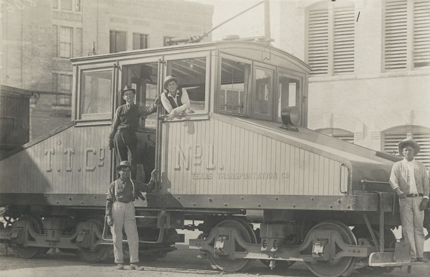
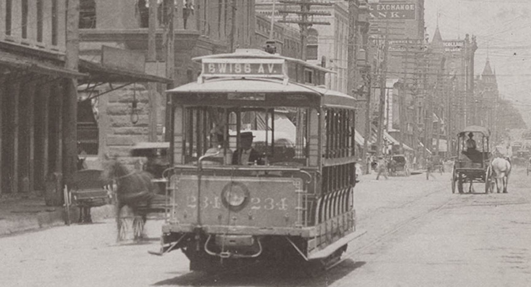
The Swiss Avenue Car on Main Street — ca. 1900

swiss-ave-streetcar_main-and-market_cook-degolyer_c1900
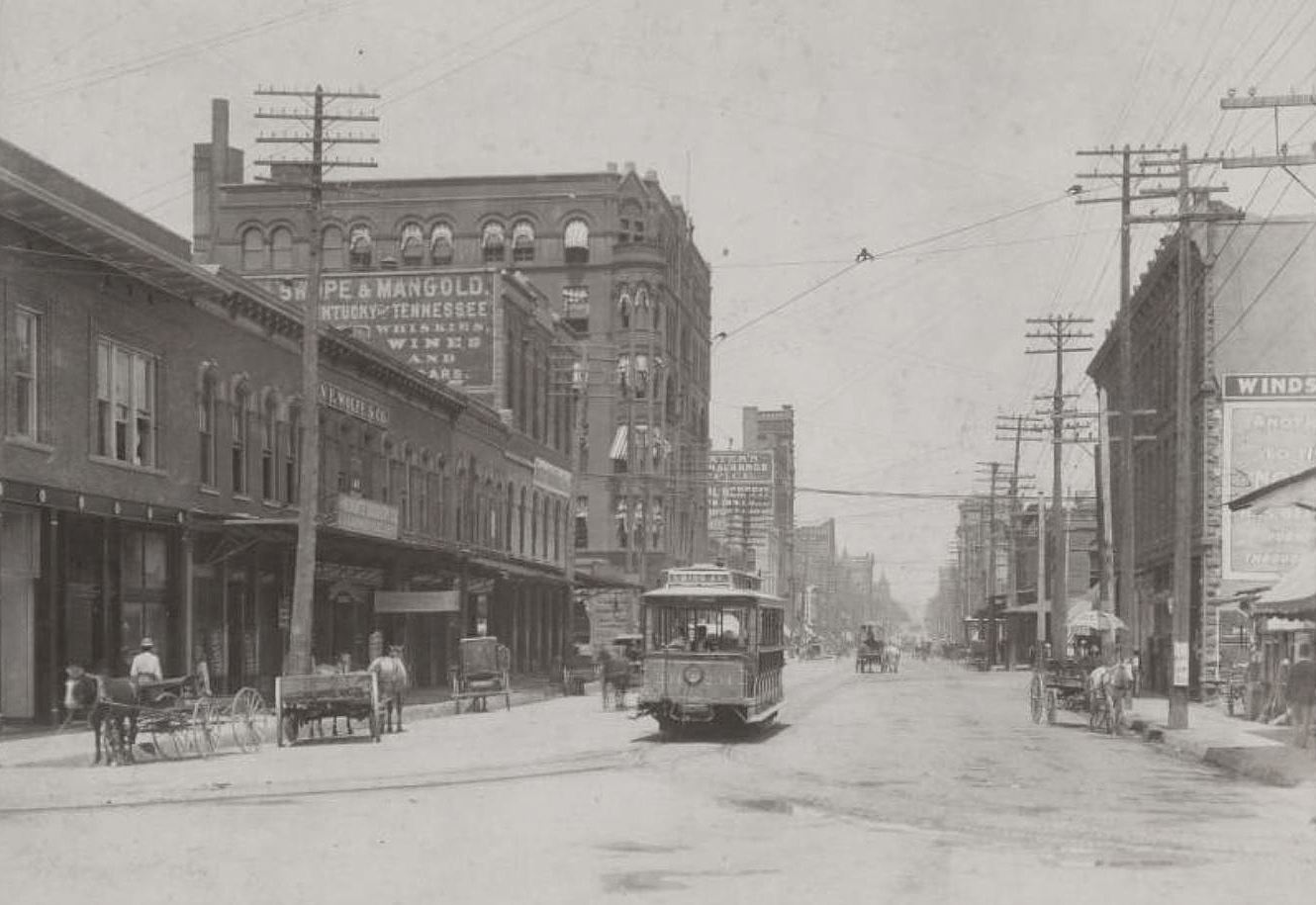
Main and Market, looking east…

by Paula Bosse

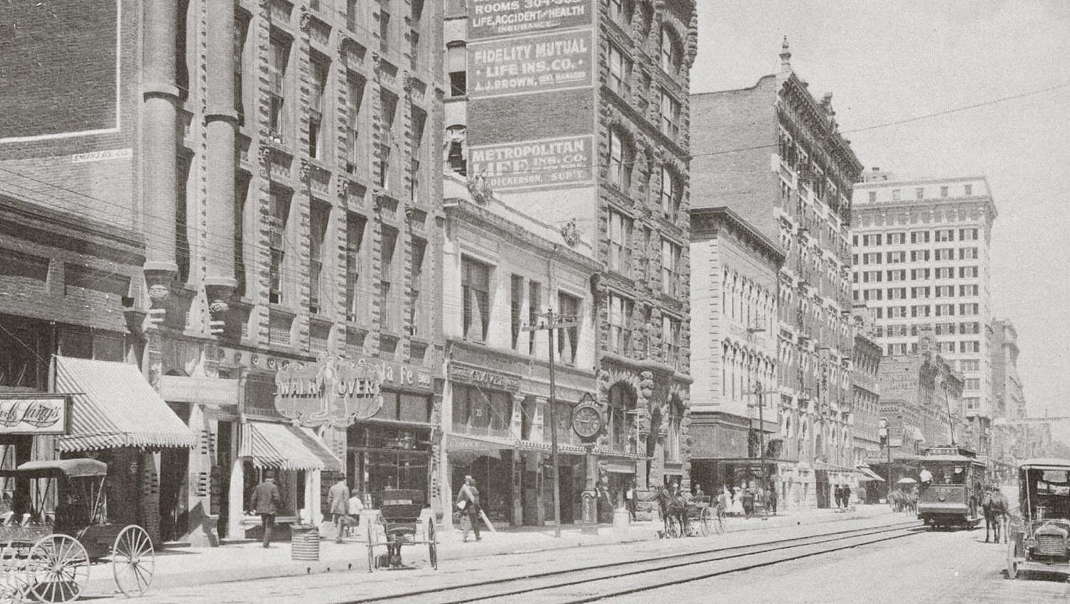
Here’s another great photo from the George W. Cook collection at SMU. This one shows Main Street sometime between 1899 and 1902 (the year asphalt was laid on Main and the year that Sanger Bros. expanded their building from two stories to six); we’re looking east from Market Street. (The aesthetically challenging view as seen today on Google is here.)

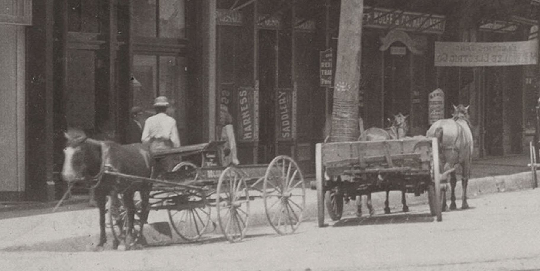
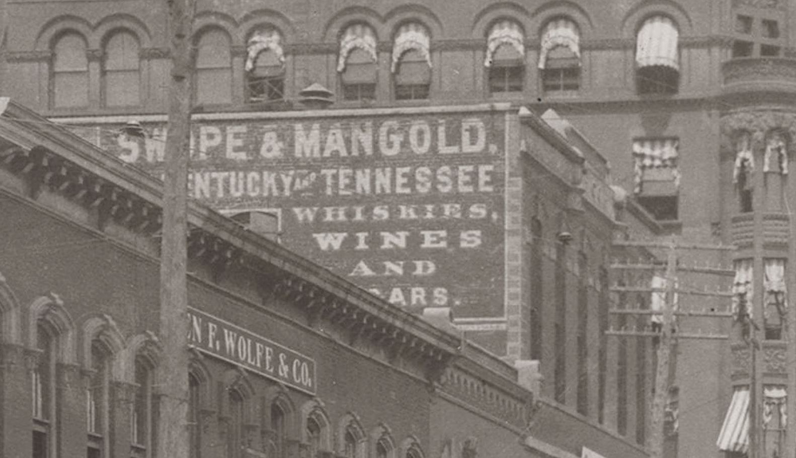
On the north side of Main (at the left), we can see horse-drawn wagons parked in front of a group of businesses including Konantz Saddlery Co., Ben F. Wolfe & Co. (machinery), a banner across the sidewalk for the Southwestern Electrical Engineering & Construction Co., Swope & Mangold wholesale and retail liquor company; then past Austin Street, on the corner, is the Trust Building, with the then-two-story Sanger Bros. building right next door (Sanger’s would build that up to six floors in 1902 and would eventually take over the Trust Building); across Lamar is the North Texas Building, with Charles L. Dexter’s insurance company advertised on the side; and, beyond, the Scollard Building, etc. The Windsor Hotel can be seen on the south side of the street in the foreground. And in the middle, an almost empty little streetcar with “Swiss Av.” on it, moving down Main underneath a canopy of hundreds of ugly electric wires zig-zagging overhead. Let’s zoom in around the photo to see a few closeups (all images are much larger when clicked).

Wagons parked at the curb:

swiss-car_1

*

Is that someone in the window looking down the street?

swiss-car_2

*

Swope & Mangold was one of the oldest “liquor concerns” in turn-of-the-century North Texas.

swiss-car_3

*

The electric streetcar shared the roadway with horses, buggies, and wagons.

swiss-car_4

*

I can’t quite make out the writing on the umbrella or on the sign posted on the pole. Part of the old Windsor Hotel can be seen at the right. At the bottom corner is a shop that sold “notions” and household goods, and just out of frame were a fish market and a meat market.

swiss-car_5

*

And the little Swiss Avenue car 234. Lotsa free seats.

swiss-car_4-a

*

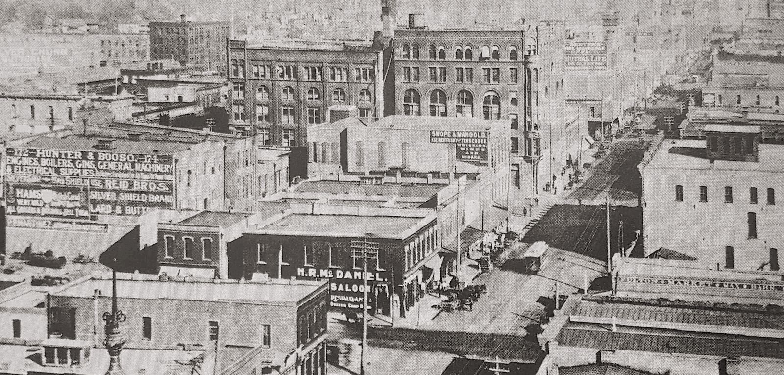
Here’s another view of Main Street looking east, taken around the same time. There’s even a streetcar in about the same spot.

main-street-birdseye_ca-1900_dallas-rediscov_p42_DHS

*

See the 1899 Sanborn map for this general area here (note that Record Street was once Jefferson Street).

***

Sources & Notes

Top photo — titled “Main Street between Austin and Market Streets” — is from the George W. Cook Dallas/Texas Image Collection, DeGolyer Library, Central University Libraries, Southern Methodist University; more information on this photo is here.

The circa-1900 bird’s-eye view photo at the bottom is from the collection of the Dallas Historical Society, found in the book Dallas Rediscovered by William L. McDonald (p. 42).

*

Copyright © 2017 Paula Bosse. All Rights Reserved.

San Antonio Extra: The Texas Transportation Co. and the Pearl Brewery Electric Freight Trolley

texas-transportation-co_cook-coll_degolyer_smu_san-antonioT. T. Co. No. 1, at your service… (click for larger image)

by Paula Bosse

I come across a lot of interesting Texas photos that have nothing to do with Dallas, so I think I might, on occasion, post them here, knowing that someone else is also likely to find them interesting. Like the one above.

This photo is from the incredible gift that just keeps giving, the George W. Cook Dallas/Texas Image Collection, held by the DeGolyer Library at SMU. Most of the items in the collection have a Dallas connection, but there are several others of general Texas interest.

When I saw this photo I wasn’t sure what it was. It looked like an electric trolley, but I’d never seen a shape like that before. It turns out it was, indeed, an electric freight locomotive. It was one of two locomotives that belonged to the Texas Transportation Co.’s tiny fleet of two — this was engine No. 1. The T.T.C. operated a freight service on their very short 1.3-mile track for 113 years (1887-2000), serving primarily the Pearl and Lone Star breweries of San Antonio, running freight to and from the breweries and the Southern Pacific rail yard. (More at Wikipedia, here.)

Here’s a later photo of the locomotive (October, 1928), now emblazoned with the Pearl Beer logo.

texas-transportation-co_1928_denver-public-library

As hard as it is to believe, this electric freight trolley ran along the streets of San Antonio until the year 2000, when it became a victim of the Pabst Brewing Company’s acquisition and shuttering of the Pearl Brewery. Without the brewery, there was no need for the trolley to continue to run. A month before it stopped running, a man shot video footage of the locomotive(s) trundling through San Antonio. I particularly liked seeing the locos push freight cars as well as pull them (seen at about the 12:50 mark). (Read the notes of the man who shot the video on the YouTube page under “Show More.”)

*

***

Sources & Notes

Top photo — titled “T. T. Co. No. 1. Texas Transportation Co.” — is from the George W. Cook Dallas/Texas Image Collection, DeGolyer Library, Central University Libraries, Southern Methodist Unviersity; more information about this photo can be found here.

Second photo — titled “Texas Transportation Co. locomotive, engine number 1, engine type Electric” — is from the Otto C. Perry Memorial Collection of Railroad Photographs, Western History Department, Denver Public Library; more information on this photo can be found here.

A great short, illustrated history of the Texas Transportation Co. and the various locomotives that ran on its rails can be found at the Don Ross Group website, here (be sure to read the reminiscences of a man who worked at the Pearl Brewery as a college student in 1960 at the bottom of the page).

I wrote about electric interurban freight-hauling locomotives in the Flashback Dallas post “Interurbans: Freight Movers?”

Click photos to see larger images.

*

Copyright © 2017 Paula Bosse. All Rights Reserved.


Union Station — ca. 1916

union-station_ca-1916A century ago… (click to see larger image)

by Paula Bosse

A new Union Station, bustling with activity, as seen across a scrubby vacant lot which, today, is the home of the Dallas Morning News building at S. Houston and Young. See the view today, here.

The photo shows the baggage shed which used to be on the south side of the building as well as the passenger bridge heading to and from the trains, with steps leading down to the platforms. See the details on the Sanborn map from 1921 here.

Union Station has weathered some difficult times and suffered from neglect after the golden age of train travel ended, but after recent extensive renovation/restoration, the historic landmark looks as good as new!

*

Copyright © 2017 Paula Bosse. All Rights Reserved.


Main Street’s Varied Modes of Transport — ca. 1909

main-street_tsha-meeting-1977_portalPowered by oats, electricity, and gasoline…

by Paula Bosse

Here’s Main Street, looking east, from about Field. This is another of those odd photos showing streets shared by horse-drawn buggies and automobiles. And an electric streetcar. The days of those horses clip-clopping down Main Street were running out. (And I’m sure the horses were much relieved.)

This photo was taken sometime between 1909, when the Praetorian Building opened (it’s the tall white building in the background, with the Wilson Building behind it at the other end of the block), and 1911, when the street numbers changed (you can see the address of “303” next to the words “Santa Fe” — the Gulf, Colorado & Santa Fe Railway offices were at 303 Main Street in the 1909 city directory).

Also seen in this photo are the tall Scollard Building (the one with the advertising painted on its side) and, one building away, the Imperial Hotel.

See what it looks like now, here.

***

Sources & Notes

Photo from a pamphlet for the Texas State Historical Association’s annual meeting in Dallas in 1977, found on the Portal to Texas History, here. Sadly, the photo was printed in sepia ink, which, argh. As always, if you know of a sharper image, please let me know!

*

Copyright © 2017 Paula Bosse. All Rights Reserved.

“Classified System” Parking Stations — 1930s

classified-system_colteraIs that a ship? And an iceberg? (click for larger image)

by Paula Bosse

Here’s a cool little ad for what was basically a parking garage that also sold gas and tires (and which seems to have had a ship on top of its building … a building which might be shaped like … an iceberg?). This snazzy-looking garage was at 501 N. Akard (at Patterson) — it was one of several “Classified System” garages that dotted downtown from the early 1930s until at least the early ’70s. The Akard location was station No. 1.

Below, an ad from 1935 informing patrons that they could drive in, have tires installed, and pay for them sometime in the future — for as little as 50 cents a week (which would come out to about $35 a month in today’s money). “YOU DON’T NEED CASH.” (Click ad to see a larger image.)

classified-parking_dmn_061535
1935 ad

classified-parking_dmn_061535_det

I love the kooky design of the building, but that ship is just … odd. I like it, I just don’t get it. Maybe that’s the “classified” part.

***

Sources & Notes

Color image is a matchbook cover found on Flickr, here.

*

Copyright © 2017 Paula Bosse. All Rights Reserved.


Traffic at Ross and Pearl — 1920s

ross-and-pearl_galloway_park-citiesLooking northeasterly on Ross from N. Pearl (click for larger image)

by Paula Bosse

The photo above shows the intersection of Ross and Pearl. The streetcar tracks ran along Pearl. We’re looking northeasterly on Ross. To the left, out of frame, would be the Sacred Heart Cathedral (renamed Cathedral Santuario de Guadalupe in 1977). The photo comes from Diane Galloway’s wonderful book The Park Cities, A Photohistory. Her caption:

Traffic jams such as this one at Ross and Pearl Streets during the twenties encouraged Dallasites to pack up and move to newer developments away from the city.

With the crowd of people at the left, I think the traffic in this photo might have been caused by church-going motorists. The license plates on the cars seem to match those from 1927 and 1928 (links to license-plate-dating sites at bottom of post).

That impressive house at the top left with the pointed turret? At the time of this photograph, it was the George A. Brewer Undertaking Company. Like the two-blocks-away Belo Mansion, which was converted into the Loudermilk-Sparkman funeral home in 1926 (seen here), this spectacular house was once a private residence. It was built by Charles F. Carter (1848-1912), a wealthy cotton merchant, sometime between 1892 and 1895. It took up a huge lot at what is now the northeast corner of Ross and Crockett (see it at the bottom left of the 1921 Sanborn map, here). Here’s what the house looked like, circa 1894. (All pictures are larger when clicked.)

carter-house_church_dallas-through-a-camera_ca-1894_SMU

And, below, you can just see part of the house in a 1910 photo of the new-ish Cathedral at the corner of Ross and Pearl.

 sacred-heart-cathedral_1910_dpl

In 1920 or ’21 the Brewer Undertaking Co. moved into this house at 2303 Ross Avenue and operated as one of the city’s most prominent funeral homes until 1931 when they moved into a new location farther down Ross. When Brewer moved out, the beautiful house was demolished. In its place … a used car lot. Argh. In 1940, Lone Star Olds (later Lone Star Cadillac) moved in, eventually bought up the whole block, and became one of Dallas’ legendary car dealerships. It moved from its Ross Avenue location in 1985.

lone-star-cadillac_ross-ave_squire-haskins_uta

*

Also, even though it isn’t really visible in the top photo, across the street from the old Carter house — at 2310 Ross — was Brynce Court, a u-shaped apartment building. I haven’t been able to verify this, but The Dallas Morning News had a blurb about the “First Apartments” in the city which read as follows:

Dallas’ first apartment complex was a two-building development at 2310 Ross Ave. Built in 1919 [note: it appears to have been built in 1912], Brynce Court was the first set of apartments housed in more than one building.” (DMN, Jan. 7, 1984)

I mention this because it’s a cool little factoid, but also because I stumbled across a photo of it in an ad while looking for info on Lone Star Olds-Cadillac. So I have to show it. Surprisingly, this apartment block (which probably looked a lot less charming after fifty years) stood at that location until at least 1964.

brynce-court_dmn_051521
Dallas Morning News, May 15, 1921

brynce-court_dmn_042212
DMN, April 22, 1912

*

I always like to look at things in the background of old photos. Here’s an extremely blurry magnified detail from the top photo, showing a two-story building of shops and businesses at Ross and Leonard. Included in these businesses is the Imperial Drug Store — it’s a little hard to make out, but the vertical sign with white letters appears to read “DRUGS” (this building can be seen in the 1921 Sanborn map mentioned above).

ross-pearl_dallas-rediscovered_det

Below, the businesses and residences along Ross Avenue — between  N. Pearl and Leonard — from the 1927 Dallas directory.

ross-avenue_1927-directory

Ross and Pearl these days looks nothing like that top photo. See what the same view looks like today, via Google Street View, here. At least the Cathedral lives on.

***

Sources & Notes

Top photo from Diane Galloway’s book The Park Cities, A Photohistory (Dallas: privately published, 1989); from the collection of John Stull/R. L. Goodson, Jr., Inc., Consulting Engineers.

Photo of the C. F. Carter House is from the book Dallas, Texas Through a Camera, a collection of photos by Clifton Church.

Photo of the Cathedral of the Sacred Heart from the Dallas Public Library, taken in 1910.

(Cropped) photo of Lone Star Cadillac by Squire Haskins from the Squire Haskins Photography, Inc. Collection, University of Texas at Arlington Special Collections; more info is here (click thumbnail on UTA page to see much larger image).

Info on dating Texas license plates can be found here (PDF), here, and here. (If the first link doesn’t open, Google “The History of Texas License Plates.” It’s a report issued by the Texas Department of Transportation. It’s 255 pages long (!) and it’s exhaustive!)

Click pictures to see larger images.

*

Copyright © 2016 Paula Bosse. All Rights Reserved.

The Sam Houston Zephyr Leaving Union Station, Crossing Over the Triple Underpass — 1950

zephyr_triple-underpass_1950_portalThe SHZ heading out of Dallas… (click for larger image)

by Paula Bosse

The title pretty much says it all. The Sam Houston Zephyr passenger train is seen crossing over the Triple Underpass, heading out of Dallas. Next stop: Fort Worth. The Post Office Terminal Annex is the tall white building, the Jefferson Hotel is behind it (with the sign on its roof), and Union Station is in the background, just right of center, with the Dallas Morning News building peeking over its roofline. The Old Red Courthouse would be out of frame to the left.

Below, a view of downtown from the west, with the Triple Underpass partially cut off at the very bottom, and Union Station just out of frame at the right.

downtown_aerial-photo-service_postcard_cook-collection_smu_cropped

In asking members of Facebook’s Texas Railroad History group about the top photo, Gerald Preas, one of the members, made this comment, full of interesting little tidbits (slightly edited by me):

The large building in the center is the USPO Terminal Annex. I started working there in August 1963. The buildings between TA and Union Station were part of Railway Express, used for sorting mail to and from RPO cars. That stack in back was the power station for Union Station — it had its own electric and water system, maybe sewage, too. I drank many times that cool sweet well-water. Notice cars around TA loading dock. I supervised that dock 1968/69 — we had to keep the area open. Now look where train is bending, people would park off ballast, but cars turning would swing out further and hit parked cars. That tree on the upper right led down grade to vacant parting lot. I was coming up that path when the President was shot.

***

Sources & Notes

Top photo shows the Fort Worth and Denver’s Sam Houston Zephyr train No. 4, northbound from Houston, leaving the Dallas Union Terminal Station, heading to Fort Worth. The photo was taken by Roger S. Plummer in 1950; photo from the Museum of the American Railroad, via UNT’s Portal to Texas History, here.

(Other photos of the Sam Houston Zephyr taken in Dallas — and one in Fort Worth — by Roger S. Plummer between 1949 and 1955 can be found on the Portal to Texas History site, here.)

Bottom image titled simply “Dallas, Texas” is an Aerial Photo Service postcard, from the George W. Cook Dallas/Texas Image Collection, DeGolyer Library, Central University Libraries, Southern Methodist University. I’ve edited the image a bit — see the original image and description here.

An aerial view of the same area today can be seen here, via Google.

A previous Flashback Dallas post on the stunningly beautiful Texas Zephyr can be found here.

Thanks to the members of the Texas Railroad History group on Facebook for their comments and help.

Both photos are larger when clicked.

*

Copyright © 2016 Paula Bosse. All Rights Reserved.


The Katy Building, Commerce Street

m-k-t_katy-bldg_flickr_coltera“The Katy Serves the Southwest…” (click for larger image)

by Paula Bosse

A couple of days ago I posted a photo of an M-K-T train leaving Dallas and, today, coincidentally, I came across a photo of the Katy Building, the railroad’s headquarters, at Commerce and Market. This photo shows Commerce looking west toward the Old Red Courthouse from Austin Street. An interurban car is heading east.

See the same view today, via Google Street View, here.

A photo I really love — which shows a view from about the same time looking east on Commerce — can be seen in a previous post, “Commerce & Record Streets — 1946,” here.

***

Photo from Flickr, here.

*

Copyright © 2016 Paula Bosse. All Rights Reserved.

The M-K-T Pulling Out of Dallas

mkt-leaving-dallas_peter-stewart_austin_ebayTrain whistles don’t sound so lonesome in the daytime…

by Paula Bosse

Above, an undated photo I came across on eBay a couple of months ago, showing a Missouri-Kansas-Texas train heading north from the Katy yard at the northwest corner of downtown. In the background are the twin DP&L smokestacks which were iconic landmarks until they were demolished in order to build the American Airlines Center and Victory Park. Below, a later photo taken from about the same location.

neuhoff_dpl_reunion-tower

The area between Dealey Plaza and the Neuhoff meat packing plant was crammed with tracks; below is a detail from a mid-1940s aerial photo (click to see a larger image).

aerial_long_foscue-lib_smu_1940s_det

The M-K-T split about where the photo at the top was taken, as can be seen in the Sanborn map below (from 1927) between Turtle Creek and McKinney Avenue. One track headed north, the other cut through Oak Lawn and Highland Park (now the Katy Trail), crossing Mockingbird at the Dr Pepper plant near Central Expressway.

sanborn_vol-2_key_1927

mkt-logo

***

Sources & Notes

Top photo from eBay, with the photographer of this “vintage snapshot” credited as “Peter Stewart, Austin, Texas.” (There is a crease to the lower left corner.) It is undated, but when posted to the Texas Railroad History group on Facebook, commenters suggested mid-to-late-1930s to early ’50s. It’s a bit grainy, but the number on the engine appears to be 411.

The second photo, showing the Neuhoff plant and Reunion Tower, is from the collection of the Dallas Public Library.

The aerial shot is a detail from this photo by Lloyd M. Long, from the Edwin J. Foscue Map Library, Central University Libraries, Southern Methodist University.

The map detail is from the “key” page of the 1927 Sanborn Fire Insurance Map, here. Speaking of Sanborn maps, this one from 1921 shows M-K-T tracks galore behind the DP&L plant.

Click pictures to see larger images.

*

Copyright © 2016 Paula Bosse. All Rights Reserved.


Wilson & Co., Their Clydesdales, and the Dallas Jaycees’ Safety Committee — 1951

wilson-and-co_clydesdales_ebay_1951Giant horses at the ready… (click for larger image)

by Paula Bosse

I came across this undated photo a couple of years ago on eBay, and it took a little bit of digging to come up with just what was going on here.

The Wilson & Co. meat packing and processing business began in Chicago in 1916 and quickly became one of the nation’s largest meatpackers, right up there with Armour and Swift. It expanded across the country, and one of its plants was in Dallas — in Unit 3 of the Santa Fe complex of buildings, located on Wood Street, between Field and what is now Griffin. (This building was later known as the Ingram Freezer Building and was demolished in 1988.) The Wilson company was acquired by Dallas-based LTV in 1967, and was later “spun off” from LTV in 1981

The Wilson company had owned a prize-winning “six-horse hitch” of Clydesdale horses since 1917, and they were sent around the country to promote the company and its line of processed meats. Not only were the horses prize-winners at livestock shows, they were also incredibly popular with the public. (They had made a huge splash at the Chicago World’s Fair in 1933, and it seems Budweiser took note of the promotional possibilities of the impressive animals, as the Anheuser-Busch Co. ended up buying the original team from Wilson that same year. So there were at least two competing Clydesdale teams clomping along the downtown streets of America, through at least the late ’60s.)

The photo above was taken when Wilson & Co.’s horse celebs visited Dallas in May, 1951. During their time in Big D they paraded through downtown at noontime and entertained workers on lunch breaks; at night they bunked in temporary stables in the service department of a Pacific Avenue car dealership. The photo at the top shows a public service event in which the Dallas Junior Chamber of Commerce promoted traffic safety in conjunction with the visiting horses. In the photo, the Wilson company employees (who have somehow managed to block the view of several thousand pounds of horseflesh and the huge 1890s wagon behind them) look happy during their little photo-op break from work. And in the background, we see the Adolphus Hotel (…built by the man behind Budweiser beer…), the Magnolia Building, and the Baker Hotel.

All this kind of makes me want a ham sandwich and a bottle of beer…. 

wilson_clydesdales_amazon
via Amazon

wilson-clydesdales_dmn_051151
May, 1951

wilson_1953-directory
Wood Street, Dallas city directory, 1953

wilson-and-co_1952-mapsco
1952 Mapsco

Below, a postcard advertising the appearance of the Wilson “Champion Six-Horse Team” at the 1936 Texas Centennial:

wilson-co_clydesdales_1936_ebay

wilson-co_clydesdales_1936_ebay_back

***

Sources & Notes

Photo found on eBay in 2014; on the back is the stamp of photographer Denny Hayes.

Texas Centennial postcard from eBay.

See an unimpeded view of the famous six-horse team of Clydesdales (each of which weighed, on average, two thousand pounds) in a 1954 Cedar Rapids Gazette photo, here.

A couple of interesting tidbits about the Wilson company and about the horses:

  1. Thomas E. Wilson, the founder of the meatpacking company also founded Wilson Sporting Goods
  2. As a celebratory nod to the end of Prohibition, the famed Budweiser Clydesdales were purchased from Wilson in 1933 — this was Wilson’s original team from 1917. (Clydesdale horses generally live for 20-25 years.)

Pictures and clippings are larger when clicked.

*

Copyright © 2016 Paula Bosse. All Rights Reserved.