Flashback : Dallas

A Miscellany: History, Ads, Pop Culture

Tag: Historic Dallas

Neiman-Marcus Expands — 1927

n-m_construction_1927_pioneers-of-dallas-co-FB-page_coll-frances-james_2The first addition under construction, 1927…

by Paula Bosse

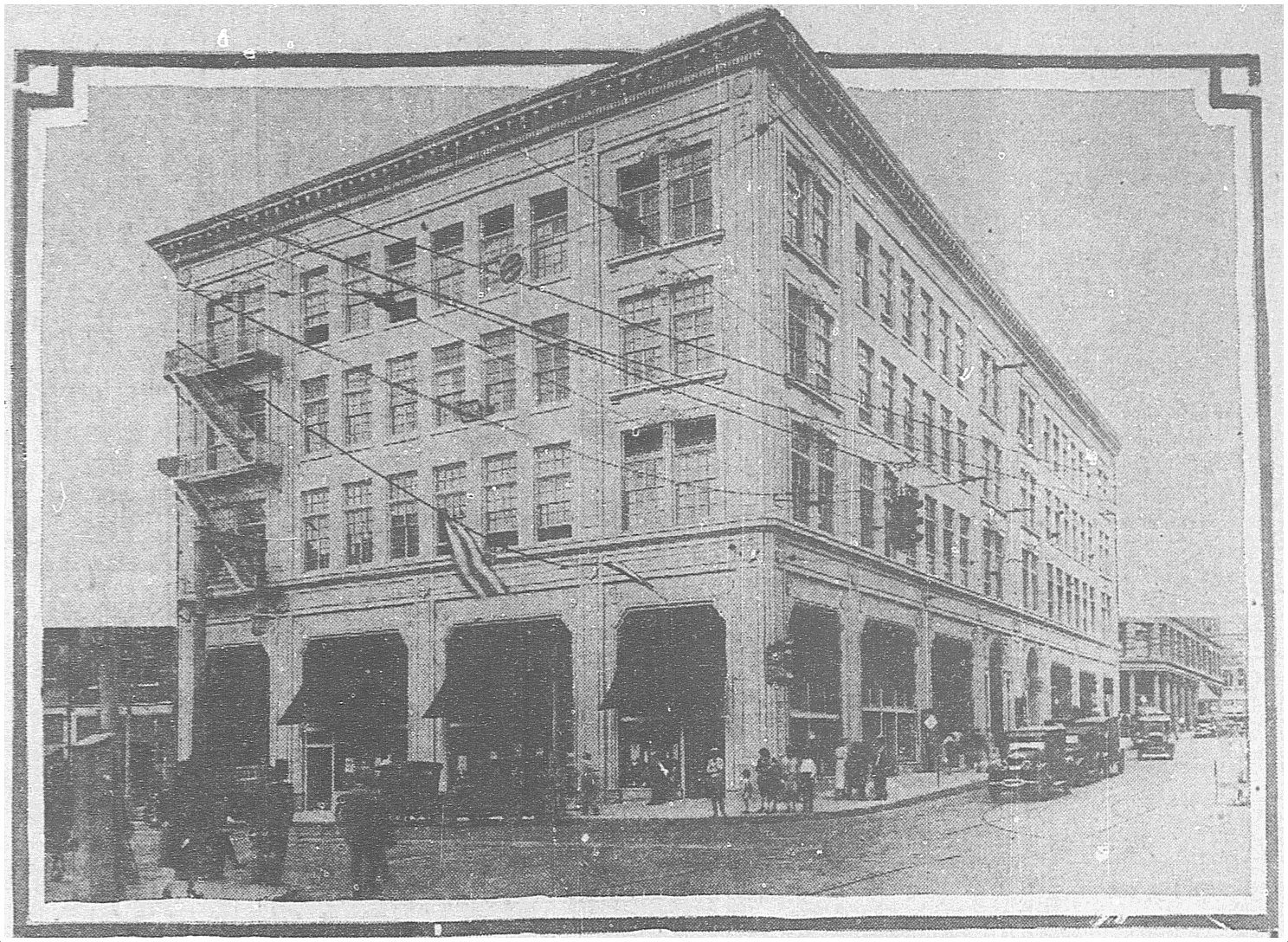
In 1927, construction began on Neiman-Marcus’ first expansion. The addition was adjacent to the famed department store, which had occupied its spot at Main and Ervay since its construction in 1914. (This was the company’s second location – their original store, which opened in 1907 at Elm and Murphy, was destroyed by fire in 1913.) The store had outgrown its old building, and expansion was deemed necessary. The new addition was designed by the Herbert M. Greene architectural firm, led by George L. Dahl. While the new building was going up, the old building was being renovated and updated. 

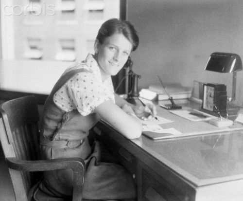
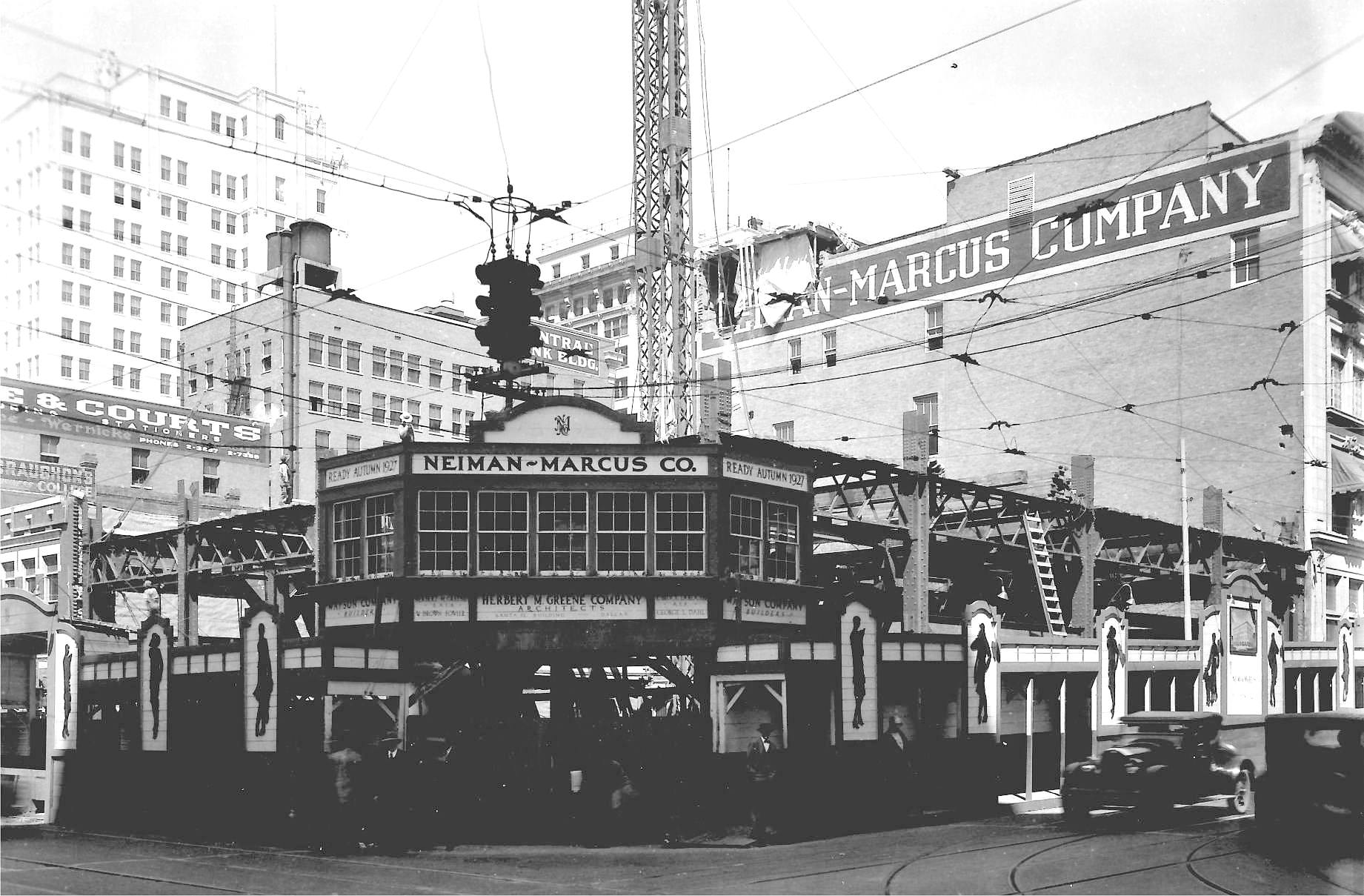
The photo above shows the construction of the addition, which extended the store’s footprint from Main all the way to Commerce. One of the interesting features of this construction was the look of the site itself.

One of the features of the Neiman-Marcus project is the ornamental barricade, containing window boxes and fashionable silhouettes, which has been put up around the new construction. (Dallas Morning News, May 8, 1927)

It’s the nicest-looking hard-hat area I’ve ever seen!

The new building (which was four floors, but was designed so that sixteen additional stories could be added if needed) opened in October, 1927. Less than a month after the formal opening of this new building, another addition was announced — it opened the following year. With that “third unit” opening in 1928, Neiman-Marcus had increased its size by 50% (there would be further expansions over the years), and its sales were the highest in the company’s history. Also, notable at this time was the fact that a full 40% of the store’s sales were to people who lived “in other cities of the Southwest.”

The formal opening on Oct. 3, 1927 attracted a crowd estimated at more than 25,000 people. Invited guests wore gowns and tuxedoes.

n-m_new-addition_dmn_100227
Expansion completed.

*

n-m_construction_dmn_100227_full-page-ad
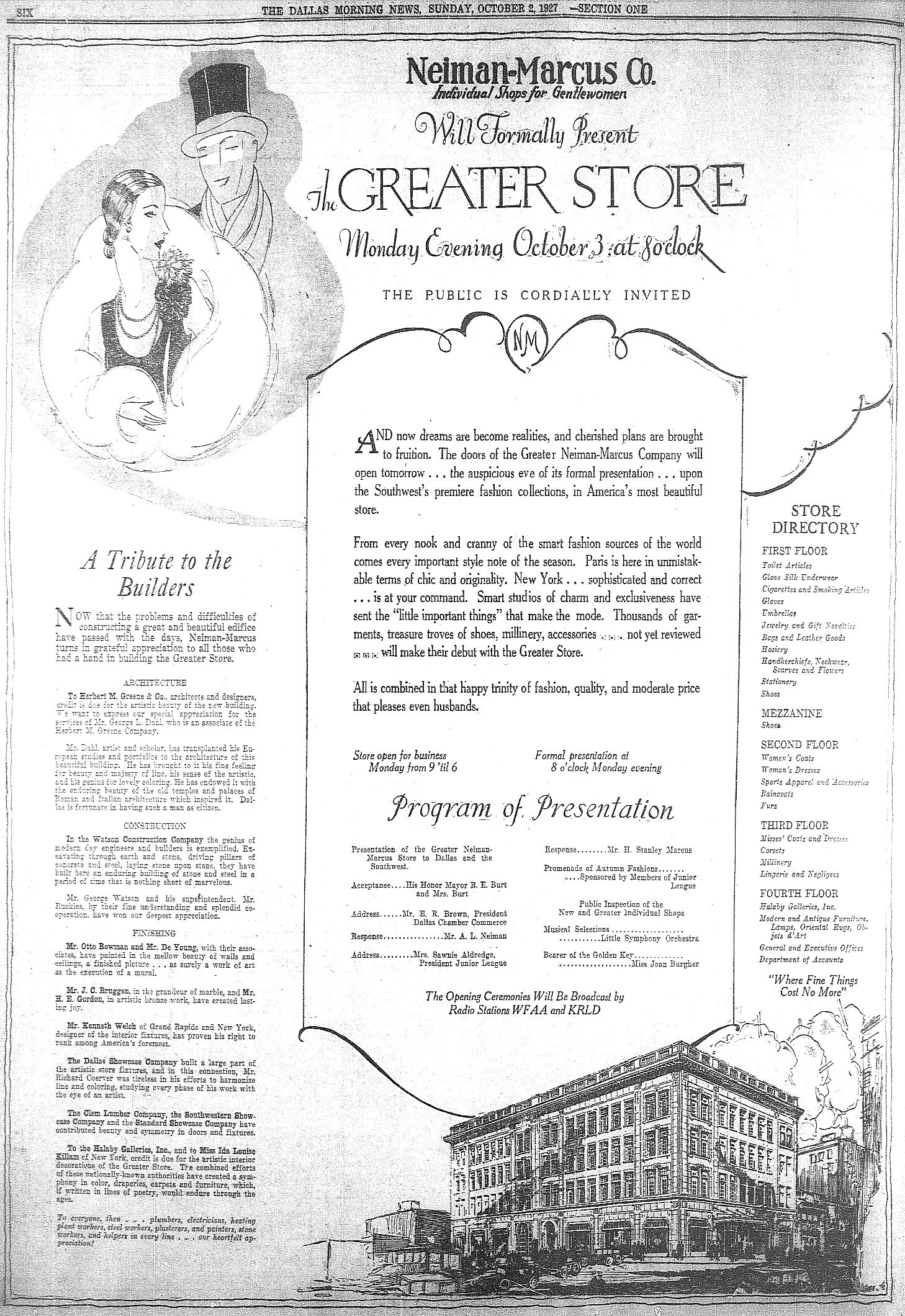
Oct. 2, 1927 (full-page ad — click to see larger image)

n-m_addition_dmn_100227_architects
Oct., 1927

***

Sources & Notes

Top photo was posted in the Facebook group Pioneers of Dallas County; it is from the collection of Dallas historian Frances James.

A special section of The Dallas Morning News which coincided with the opening of the expanded store appeared in the October 2, 1927 edition of the paper; in it are several photos and articles.

Read more about the history of the Neiman Marcus building on Wikipedia, here.

*

Copyright © 2016 Paula Bosse. All Rights Reserved

Thank You, Preservation Dallas!

wilson-house_FB-page_cover-photoThe historic Wilson House, home of Preservation Dallas

by Paula Bosse

I was invited by the nice people of Preservation Dallas to be part of their Summer Sizzlers Series and to present my first-ever lecture/talk: on how I write the blog and what resources I use. Somehow I managed to stand in front of a packed roomful of people (one of my greatest fears) and talk for 90 minutes (!) — and, surprisingly, I think my presentation was mostly coherent. I have to admit, a lot of it is a hazy blur, but I was happy to find that it was an enjoyable experience. I had a great time, and it was nice to talk to so many people who are as interested in Dallas history as I am.

Thank you Irene Allender, David Preziosi, and Donovan Westover for inviting me and for hosting such a nice event!

preservation-dallas_logo_2016

preservation-dallas_summer-sizzlers

***

Sources & Notes

Photo at top shows the beautiful Wilson House, built in 1899 at the corner of Swiss and Oak and current home of Preservation Dallas. Read more about the house here; read about the Wilson Block Historic District here. Take a virtual Google Street View tour of the wonderful two blocks’ worth of historic houses here. (Photo from the Preservation Dallas Facebook page.)

After the lecture, I had several people ask about the PowerPoint 2016 presentation I’d made. This was the first time I’d ever used PowerPoint, and it worked really well for showing many (MANY!) photographs to the audience. For those of you who came up and asked me about it, the very, very well done YouTube tutorial I used to teach myself PowerPoint is here. It’s in 10 segments — about 3 hours in all — you might not need everything in it, but I found it very helpful.

*

Copyright © 2016 Paula Bosse. All Rights Reserved.

From the Vault: Babe Didrikson, Oak Cliff Typist

babe-corbis_102132
Babe at her desk in Dallas, 1932

by Paula Bosse

It’s Olympics time again, so why not look back at the career of a great Olympian — and one of the greatest athletes of all time — Babe Didrikson (later Babe Didrikson Zaharias). Babe came to Dallas as a teenager when she was recruited to play basketball for an insurance company. And the rest is history. Read about Babe in Big D here.

*

Copyright © 2016 Paula Bosse. All Rights Reserved.

The Twin Standpipes of Lakewood Heights: 1923-1955

lakewood_water-towers_reminiscencesAbrams and Goliad, y’all… (click for larger image)

by Paula Bosse

The two large water towers pictured above loomed over the East Dallas neighborhood of Lakewood Heights for over 30 years. They sat at the southwest corner of what was then known as Greenville Road (not to be confused with Greenville Avenue) and Aqueduct Avenue — the streets are known today as Abrams Road and Goliad Avenue. The towers replaced a previous (single) water tank, which, by the early 1920s, was proving inadequate for the needs of an exploding Lakewood area.

These water tanks — called “standpipes” — were really big: each was 100 feet tall, 60 feet in diameter, and held two million gallons of water. They were erected in October, 1923 and, rather surprisingly, stood until 1955. Even though I grew up in this part of town, I never knew about these tanks until a couple of years ago when I saw a photo in a Dallas history group. It’s hard to believe those industrial behemoths were smack dab in the middle of what is now a jam-packed residential neighborhood.

**

Here are a few photos featuring cameo appearance by the omnipresent tanks. In the first one, from the 1930s, they can be seen at the top right, ghostlike in the distance.

lakewood-shopping-ctr_streetcar-tracks_ca1938_reminiscences

*

Then there’s this fantastic aerial shot of what would later become the fully developed Lakewood area (and beyond). Looking east, White Rock Lake is in the distance, and the two towers — brand new when this photo was taken in 1923, and taller than anything else in the photograph — are at the left.

east-dallas_lakewood_fairchild_1923_cook-coll_degolyer_smu

Let’s zoom in a bit:

east-dallas_lakewood_fairchild_1923_cook-coll_degolyer_smu_det

*

And here is a really wonderful photo which was posted in the Dallas History Facebook group by Mary Doster from the collection of her husband Jim Doster, showing Abrams, looking north, in 1925. (The location of the twin tanks was actually outside the Dallas city limits in 1919 — see the boundary on a 1919 map here.) I never get tired of seeing streetcars, especially traveling down streets I drive everyday.

water-tanks_abrams_dallas-hist-FB-jim-dosterCollection, Jim Doster

**

A few articles about the tanks’ beginning in 1923.

water-towers_dmn_022723Dallas Morning News, Feb. 27, 1923

water-towers_dmn_100723a
DMN, Oct. 7, 1923

water-towers_dmn_100723b
DMN, Oct. 7, 1923

*

Here’s a screenshot from a silent film produced by the City of Dallas waterworks department, showing them at traffic-level, with a view to the northwest from Abrams.

stand-pipes_lakewood_TAMI_water-dept-film_6.39

The tanks were dismantled in 1955 (pertinent articles are listed below, in the “Notes” section). Their fate, post-dismantling? One of them was destined to be reassembled in Tarrant County for the Hurst-Euless-Bedford water system, and the other one was “to be kept as stand-by storage for the city” (DMN, June 7, 1955).

standpipes_dmn_060755
RIP in HEB…

***

Sources & Notes

First two photos from the book Reminiscences, A Glimpse of Old East Dallas.

Aerial photo — titled “East Dallas — 1923” — is a Fairchild Aerial Surveys photograph, from the George W. Cook Dallas/Texas Image Collection, DeGolyer Library, Central University Libraries, Southern Methodist University; more information is here. (I have adjusted the color.)

Screenshot is from a City of Dallas silent film, shot for the water department — the film is in the TAMI collection here, and the standpipes pop up at the 6:39-ish mark. Thanks to John Botefuhr for posting the link to this film on the Lakewood 1925-1985 Facebook group.

More on the tanks’ removal in 1955 can be found in these Dallas Morning News articles:

  • “Familiar Old Landmark To Be Removed” (DMN, March 20, 1955)
  • “Offers Vary on Standpipe” (DMN, April 26, 1955)
  • “East Dallas Landmark Coming Down” (DMN, June 7, 1955 — has photo taken from inside the tank looking up as dismantling was underway)

The present-day view seen in the top photo — looking south on Abrams — can be seen on Google Street View here.

A very interesting Sanborn Map from 1922 — before the twin tanks were built, but still showing the “Lakewood Heights Water Works” — can be found here. There’s, like, nobody living there, man.

I’d love to see other photos of these particular “standpipes” — if anyone has any, forward them to me and I’ll include them in this post. Contact info is at the top.

As always, images are magically larger when clicked.

*

Copyright © 2016 Paula Bosse. All Rights Reserved.


Beautiful South Ervay Street — ca. 1910

ervay_coltera_flickrStreet life in South Dallas

by Paula Bosse

Today, a few hand-colored postcards from around 1910 showing the lovely houses that used to line Ervay Street in South Dallas. Hard as it is to believe today, the stretch of South Ervay from just outside the central business district down to its end at Forest Avenue (now Martin Luther King, Jr. Blvd.), was once a very nice area where many of the city’s most fashionable and well-to-do Jewish families (and, later, African American families) lived. The intervening century has not been kind to South Dallas. I’m not sure of the location in the postcard above, but it certainly looks like a very pleasant neighborhood — one that no longer exists in this mostly blighted area.

*

Below, S. Ervay looking south. The rounded top of Temple Emanu-El can be seen at the left. The light-colored building in the next block was the Columbian Club. The hotel most recently known as the Ambassador (which burned down three years after I originally wrote this post) is set back on a curve of the street and is hidden by the Columbian Club. The red building is the Hughes candy plant (still standing). A Google Street View of this area today can be seen here.

ervay-street_ebay

*

Below, we see a view still looking south, but now much farther down Ervay, almost to Forest Avenue (now MLK). The church on the left is the James Flanders-designed Ervay Street Methodist Episcopal Church (South), built in 1908 at the corner of corner of Ervay and South Boulevard — it’s interesting that a Methodist church was located in the center of Dallas’ largest Jewish residential neighborhood. (More on the church from a Dallas Morning News article from July 1, 1908, here. See this area on a 1922 Sanborn map here.)

ervay-residence_coltera

Not seen in the view above is one house worth mentioning. The house — just out of frame at the left, with the steps leading up to it, was the home of Simon Linz, of Linz Jewelers fame. Here is what the Linz house looked like in 1908:

linz-house_dmn_010108Dallas Morning News, Jan. 1, 1908

Remarkably, this house is still standing. It is currently a funeral home at 2830 S. Ervay. The present-day image below, showing the pretty house and the neatly landscaped yard, is a little deceptive; see what the Google Street View looks like just south — where the Flanders church once stood — here. (If you’re up to it, reverse the Google view and move back toward town.)

linz-house_2830-828-s-ervay_google
Google Street View

Hold on, little house!

This was once such a beautiful part of Dallas….

ervay_postcard_clogenson_postmark-1908

**

Below, a detail of a 1919 map showing S. Ervay down to Forest. The purple star shows the location of Temple Emanu-El and the Columbian Club. The green star shows the location of the Linz house and the Ervay St. Methodist Episcopal church. (Click for larger image.)

e-ervay_map_1918_portal
1919 map via Portal to Texas History

 ***

Sources & Notes

First and third postcards are from Flickr: here and here. Others found on eBay.

*

Copyright © 2016 Paula Bosse. All Rights Reserved.

“Greetings From Dallas, Texas” — 1955

greetings-from-dallas-texasDallas?

by Paula Bosse

Um….

Somehow Anna Belle and her family found the Cotton Bowl. Over yonder, past that ridge.

greetings-from-dallas-texas_back

***

Sources & Notes

Postcard purporting to be “Dallas, Texas” from eBay.

**

UPDATE: A person commenting on Facebook says that he thinks this shows “Cedar Mountain, near where Joe Pool Lake was built” — an area which actually is within the Dallas city limits. I’m not familiar with that area. Does this postcard show this view? Read about the Cedar Mountain Preserve here; and about Joe Pool Lake here. Check out a map that shows the City of Dallas boundary, here.

Read about Cedar Mountain (“…that wooded white rock ridge that runs from Eagle Ford to Cedar Hill…”) in the Dallas Morning News article “Bear Slapped Him But He Survived” by Kenneth Foree (Sept. 1, 1948).

Apologies, Cedar Mountain and Rembrant (sic) Post Card Company, if I have made unfounded sarcastic comments.

**

UPDATE TO THE UPDATE: I have to admit, nothing I’ve posted before has stirred up quite so much controversy. This post has been shared quite a bit, and I’ve dipped into Facebook pages where members are discussing this idyllic photo. Half swear up and down there’s no way this could be anywhere near Dallas, and the other half are pretty certain it’s in the Cedar Hill area.

Is it possible that it could be the Cedar Hill area (aka “The Hill Country of the Metroplex”)? The highest point in North Texas is just a stone’s throw from Dallas. According to the Wikipedia entry, it “stands at an elevation of about 800 feet (240 m) above sea level — the highest point in a straight line from the Red River at the Texas-Oklahoma border to the Gulf Coast.”

The Old Penn Farmstead was a working family farm/ranch from the 1850s until the 1970s (remaining in the Penn family the entire time). Photos show that the fence construction on the Penn property is the same as that seen behind the horsies in the postcard. There were several large-ish farms and ranches nearby, several of which had horses. There were even a couple of “retreats” operating in the area in the late-1940s and ’50s (notably, the 520-acre retreat sponsored by the Dallas Baptist Association).

Even though it’s likely this was just some sort of stock Western-looking photo used by the postcard company, I suppose it could show the unexpected beauty around what is now the Cedar Hill State Park, Cedar Ridge Preserve, Cedar Mountain Preserve, Dogwood Canyon Audobon Center, Joe Pool Lake, Mountain Creek Lake, etc. I mean, I’ve never seen anything around here that looks remotely like this, but a lot of people have some very strong opinions!

Watch a short Texas Parks & Wildlife video about Cedar Hill State Park here; the Penn Farmstead is located here and is seen in the video.

Here’s a 1985 article about the 11,000 nearby acres which would soon be inundated in the construction of Joe Pool Lake. (Click article to see larger image.)

joe-pool-lake_FWST_050685a

joe-pool-lake_FWST_050685b
Fort Worth Star-Telegram, May 6, 1985

**

UPDATE TO THE UPDATE OF THE UPDATE: It appears that the Rembrant Post Card people will tell you whatever you want to believe! The same image has been found without “Dallas” but with “Colorado” on it (see link in comments section). Horrors! So, anyway. After all that, my original sarcastic tone stands. Always trust your inner cynic! At least I learned about Cedar Hill!

UPDATE, ETC.: And now this saga has been taken on by intrepid Dallas Morning News reporter Charlie Scudder! Read his coverage, here.

UPDATES, INCORPORATED: And, somehow, this story ended up in the pages of the actual paper edition of The Dallas Morning News. Lordy.

DMN_080316
DMN, Aug. 3, 2016

*

Copyright © 2016 Paula Bosse. All Rights Reserved.

Dallas Skyline — ca. 1974

skyline_aerial_1974_getty-images_watermarkSo many landmarks! (click for larger image)

by Paula Bosse

I try to avoid using photos with watermarks, but this is a great view of the Dallas skyline, taken by famed photographer Charles Rotkin. Below, another of his photos.

aerial_skyline_corbis_1974

***

Photos by Charles Rotkin. Top photo from Corbis/VCG via Getty Images. Bottom photo ©Charles E. Rotkin/CORBIS (I can no longer find this image on the new Getty site). CORBIS/Getty says that both of these photos were taken on Jan. 1, 1974, but I’ve found that their date info is sometimes inaccurate.

2004 obituary of Charles Rotkin is here.

Click photos for larger images.

*

Copyright © 2016 Paula Bosse. All Rights Reserved.

Dallas Scenes by Florence McClung — 1940s

mcclung_dallas-cityscape_1941_kever-collectionFrom the collection of Mark and Geralyn Kever

by Paula Bosse

Florence McClung (1894-1992) — a painter, printmaker, and pastelist in the circle of Regionalist artists known as The Dallas Nine — lived in Dallas and often painted nearby rural scenes as well as more rugged Western landscapes. I haven’t seen many urban scenes by McClung, but there were two oil paintings that appeared in a one-woman show at the Dallas Museum of Fine Arts in the spring of 1945 which I’d love to find images of: “Triple Underpass” and “Big D,” the latter of which sounds very similar to the one seen above, “Dallas Cityscape,” from the collection of Mark and Geralyn Kever (whose impressive collection of Texas art can be seen in the Jan./Feb. issue of American Fine Art Magazine — jump to page 53 in the PDF to find the story, “Cream of the Crop”). (UPDATE: “Triple Underpass” has surfaced! More here.)

Here’s another urban scene, “Industrial Dallas,” with what looks like the Medical Arts Building in the background.

mcclung_industrial-dallas_david-dike-gallery_jan-2016-catDavid Dike Fine Art

I always love to see artistic renderings of the Dallas skyline, and I really like these two city scenes which are so different from McClung’s usual subject matter.

Florence McClung (née White) was born in St. Louis in 1894. Her family moved to Dallas, and she eventually studied art under several of Dallas’ finest instructor-artists (including Frank Reaugh). After several years as a college art instructor in Waxahachie, she began to participate in numerous group shows, juried shows, and one-man shows, reaching the peak of her career in the 1930s and 1940s. She died in 1992 at the age of 97. Art-wise, that spans the years from Toulouse-Lautrec to Banksy!

I had a hard time finding photos of her, but I managed to find two, including her senior photo which appeared in the 1912 yearbook of Dallas High School (more commonly known today as Crozier Tech) (where, incidentally, she was in the Art Club with Allie Tennant who went on to become a noted sculptor, best known for her Tejas Warrior at the Hall of State in Fair Park).

mcclung_florence-e-white_dallas-high-school_1912
Florence White, Dallas High School yearbook, 1912

mcclung-florence_circa-late-1930s
Florence McClung, circa late 1930s

***

Sources & Notes

I ran across the “Dallas Cityscape” painting on the CASETA (Center for the Advancement and Study of Early Texas Art) site.

The top painting has the title “Dallas Cityscape” and media mentions of it carry the date 1941. I couldn’t find a painting by McClung with that title (admittedly, my sources are limited!). Also, 1941 seems off because construction of the Mercantile Bank Building (seen in the painting) wasn’t completed until 1942. I wonder if it’s possible that this painting actually was the painting McClung titled “Big D” (which was most likely painted in 1944) and was included in her 1945 show at the DMFA? Might those planes have something to do with World War II? Because the Portal to Texas History has been so nice to scan them, McClung’s application for a show at the DMFA can be seen here, and her list of works to be shown is here.

“Industrial Dallas” is from a January, 2016 auction catalogue from David Dike Fine Art.

The Handbook of Texas entry for Florence Elliott White McClung can be found here.

A selection of works by Florence McClung from the Dallas Museum of Art can be found on the SMU Central University Libraries Digital Collections site, here.

UPDATE, Oct., 2018: “Triple Underpass,” from the same period as the two paintings above, has surfaced — more about it can be found in the post “‘Triple Underpass’ by Florence McClung — 1945,” here.

All images larger when clicked.

*

Copyright © 2016 Paula Bosse. All Rights Reserved.


So You’re Considering a Move To Dallas … What’s That Tax Situation Like? — 1943

taxation_so-this-is-dallas_ca-1943_detYou and your gardener will *love* Dallas! (click for larger image)

by Paula Bosse

It’s 1943. You’re  considering relocating your business and your family to Dallas. You’ll probably be owning a mansion like the one pictured above. Should you and your large bank account settle in Dallas? I mean, is it really the best place … tax-wise?

Below is a page from a pamphlet called So This Is Dallas, a publication which was intended to sway decisions such as this. It was issued for several years by a group called “The Welcome Wagon,” and this edition came out sometime during World War II. Here’s what Big D had to offer in those days. (Click to see much larger image.)

taxation_so-this-is-dallas_ca-1943

*

Taxation…

Dallas offers a favorable tax situation that can be found in but few communities. There is no State income tax in Texas and no general sales tax.

Corporations operating in the State are subject to three forms of taxation. If they are foreign corporations, they must qualify legally in the State and pay a permit fee, an annual franchise tax and ad valorem taxes. If they are domestic corporations, they pay a fee to secure a Texas charter, an annual franchise tax and ad valoreum [sic?] taxes.

Texas laws do not discriminate against foreign corporations. The permit fee for a foreign corporation and the charter fee of a Texas corporation are arrived at in the same way, the proportionate amount of capital used in Texas by the foreign corporation and the capital stock of the domestic corporation. Franchise taxes for both foreign and domestic corporations are also assessed on the same basis.

Ad Valorem Taxes

All corporations, whether domestic or foreign, and all others owning property within the State of Texas, must render their property as of January 1 each year for city, State and county taxes. The property is rendered at its inventory value. The basis of assessment varies in different counties.

Current ad valorem taxes in Dallas are: City of Dallas, $2.45 per $100 valuation, basis of assessment 53 per cent of value; Dallas County, 74 cents per $100 valuation, basis of assessment 50 per cent of value; State, 69 cents per $100 valuation, basis of assessment 50 per cent of value.

Dallas has the lowest tax rate of any large city in the Southwest. Each city has a different basis of assessment. Reducing their rates to a basis of assessment on 100 per cent of value, net tax rates for the four leading cities in Texas are:

Dallas ….. $20.56 net per $1,000
Houston ….. $22.03 net per $1,000
San Antonio ….. $26.89 net per $1,000
Fort Worth ….. $29.25 net per $1,000

*

I don’t know what ANY of that means, but it looks like Dallas wins. Welcome to your new mansion!

***

Page from So This Is Dallas, published around 1943 by The Welcome Wagon; courtesy of the Lone Star Library Annex Facebook page.

If you recognize any of these homes, let me know and I’ll add the info here. I’m seeing what looks like Lakewood and Swiss Avenue, and maybe Highland Park and Oak Cliff.

Click pictures for larger images.

*

Copyright © 2016 Paula Bosse. All Rights Reserved.

Little Mexico: Turney & Payne — 1940

little-mexico_ca_1940_WPA-GD_DHSLooking southeast, toward Pegasus… (click for much larger image)

by Paula Bosse

Above, a photo taken in 1940 at the intersection of the unpaved Turney Avenue and Payne Street, in Little Mexico — El Barrio — just north of downtown. St. Ann’s school can be seen at the end of the street, and the Villasana Food Store (prop. Rodolfo Villasana, est. 1932) is at the left; in the distance, Pegasus atop the Magnolia Oil Building. (A similar view from 1941 during ongoing street-widening — taken a bit farther back and from a slightly higher elevation — can be seen here.)

In 1941, Turney Avenue was widened and paved and then … lost its name; it became part of the brand new Harry Hines Boulevard.

Hines Boulevard begins at Five Point, where the $100,000 Tom Field Circle will be built and stretches eight miles into Dallas over Turney Street to Cedar Springs, joining Akard at Harwood. (Dallas Morning News, July 23, 1941)

Another view of the area during this period of road work can be seen in the photo below. Ramon Alonzo’s store seen at the lower right was at 2209 Caroline. (The once-familiar “smokestacks” seen in the background belonged to the Dallas Power & Light Company, which sat on land now occupied by the American Airlines Center.)

little-mexico_1941_legacies_fall-1992

Adios, Turney. Big changes are ahead. You’ll never believe how much your old neighborhood is going to change.

**

Here are the residents and businesses along both Turney and Payne as listed in the 1939 Dallas directory, one year before the upheaval began (click to see larger images):

turney_1939-directory
1939 Dallas directory

payne_1939-directory
1939 Dallas directory

To get an idea of where Turney was, here’s a detail from a 1919 map.

map_turney-payne_1919_portal

Today? It’s part of Victory Park. If you took a right on Payne at the sign advertising “milk” (in front of the Villasana gas station), you’d be about two blocks from what is now the American Airlines Center. Yep. A current Google Street View is here.

***

Sources & Notes

Top photo from the WPA Guide and History (which has been fully scanned and may be accessed at UNT’s Portal to Texas History site, here); photo from the collection of the Dallas Historical Society.

More great photos of Little Mexico from this time can be found in the article “Little Mexico and the Barrios of Dallas” by Gwendolyn Rice (Legacies, Fall, 1991), which can be found here. (The photo of Alonzo’s store is from this article.)

Several images of Turney under construction in 1940/1941 can be see in the Department of Public Works collection at the Dallas Historical Society site, here. (The linked image in the first paragraph is from this collection.)

The top photo also appears in Dallas’s Little Mexico by Sol Villasana (his family owned the store and the gas station at the Turney-Payne intersection); see it — and a northward view of the gas station, here.

For those who enjoy articles about road construction, here are a couple of Harry Hines-related News articles which might be of interest:

  • “Dedication Rites Planned For Boulevard; New Highway Named For Harry Hines Opens About Aug. 1,” DMN, July 3, 1941. (Officials were a little optimistic with that August opening — it didn’t officially open until October, 1941.)
  • It’s weird to think of Harry Hines being an actual person, but see a photo of him at the ribbon-cutting, along with another name more familiar to us today as a freeway than as a flesh-and-blood human being, Woodall Rodgers, then mayor: “Ribbon Road Barrier Snipped,” DMN, Oct. 15, 1941.

All pictures and clippings larger when clicked.

*

Copyright © 2016 Paula Bosse. All Rights Reserved.