
Preston and Valley View: The Calm Before the Storm — 1958
by Paula Bosse
 LBJ Freeway, T-minus 6 years….
by Paula Bosse
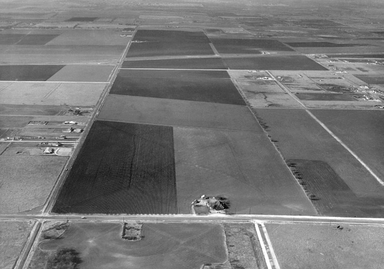
This photo makes my head hurt. The road crossing horizontally at the bottom is Preston. The vertical road at the left is Valley View Lane (the view is to the west). What we’re looking at is land soon to be eaten up by LBJ Freeway, which was built along Valley View.
This fantastic photo by aerial photographer Squire Haskins (which can be seen REALLY big at the UTA website here) is included in Oscar Slotboom’s book Dallas-Fort Worth Freeways. This is his caption to the above photo:
Preston at LBJ, 1958. This December 1958 view looks west along Valley View Lane with the Preston Road intersection at the lower left. LBJ Freeway was built along Valley View Lane with work underway in 1964. A Sears store opened in the foreground in 1965 and Valley View Mall opened in 1973. The corridor was fully urbanized by the 1980s.
The only street directory I could find fairly close to the date of this photo was the one from 1961 — which already shows development not seen in the photograph. By this time, people knew the freeway was coming, but it was still fairly sparsely developed.
Here is the listing of addresses along Valley View Lane, stretching from Inwood, east past Central Expressway. (Click for larger image.)

Valley View Lane, 1961 Dallas directory
And, below, addresses along Preston Road, moving north from Forest Lane. The thing that makes me lightheaded about this, is one particular business, way, WAY up north — out in the middle of nothing back in 1961: Lilyan’s Original Hats, at Preston and Alpha. That was my great-aunt’s hat shop. She owned that land. Imagine! She sold it, I think, in the ’70s. I can only hope she made a pretty penny!
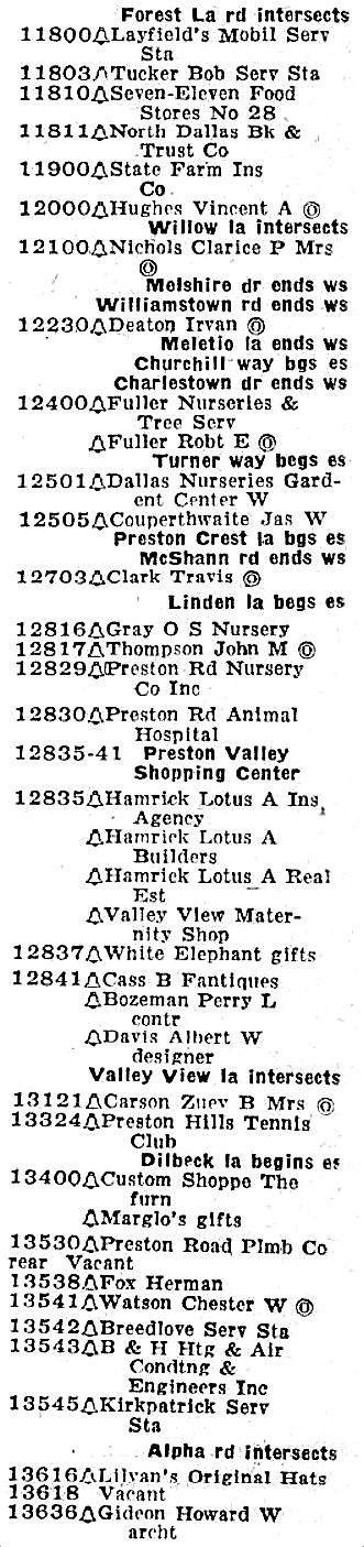
Preston Road, 1961 Dallas directory
**
Here’s what construction of LBJ looked like in 1967 — the photo shows the intersection of Central Expressway and LBJ, with a view to the southwest).

***
Sources & Notes
Photo from the Squire Haskins Photography, Inc. Collection, UTA Libraries; more info here.
More on the construction of LBJ can be found in the chapter “Interstate 635, Lyndon B. Johnson Freeway” (from Oscar Slotboom’s amazingly researched book Dallas-Fort Worth Highways), here.
The 1957 map linked above is one of many scanned road maps which can be found on Slotboom’s site — the page “Old Highway Maps of Texas, 1917-1973) is here.
*
Copyright © 2016 Paula Bosse. All Rights Reserved.

I started teaching at Thomas Jefferson in 1968 and couldn’t understand why anyone in their right mind would put a Sears store in the middle of an empty field or build a freeway going nowhere. How things have changed.
LikeLiked by 1 person
Sort of ruined the quail hunting there. My dad also used to hunt where the Galleria is today
LikeLike
Kind of amazing what all that farm land turned into. I wonder if your great-aunt bought the land from one of those farmers or if a developer bought it all up and parceled it out.
For another perspective here are screenshots from historicaerials.com with the approximate area shown in the posted photo shaded in green.
1958: http://i.imgur.com/2bkgkWR.png
1968: http://i.imgur.com/fYI8CuR.png
LikeLiked by 1 person
I lived through the initial construction of LBJ Freeway back in the 1960’s and knew all of the far north Dallas roads very well, yet seeing a photo of it now seems like another lifetime. Thanks for the memories Paula!
LikeLiked by 1 person
[…] “Preston and Valley View: The Calm Before the Storm — 1958.” The second most-viewed Flashback Dallas picture posted in 2016. In just a few short years this bucolic vista would be replaced by LBJ Freeway. […]
LikeLike
[…] “PRESTON AND VALLEY VIEW: THE CALM BEFORE THE STORM — 1958” Everyone loves aerial photos that show what the city looked like before endless asphalt sprawl hit […]
LikeLike
I found your site as a result of trying to find photos of the Farmers Branch area *before* 635 existed. I grew up in FB, just blocks away from 635, so it is hard to imagine what that must have been like. The photo at the top, while six years prior to that, gives me some idea. My uncle lived in the area when, as he said, Farmers Branch was the ‘boonies’, when Forest lane was the main road into FB.
What it must have been like.
LikeLiked by 1 person
Hi, Augustus. This is so weird, because I had been looking at this photo just minutes before you commented, wondering if that was the same wide-open landscape seen in the opening minute or two of the film linked in my most recent post: https://flashbackdallas.com/2017/12/14/white-rock-train-station-and-a-helicopter-ride/
LikeLike
Hi Paula,
I appreciate your reply. I looked at the video you linked, and honestly, I can’t tell.
What I’m wondering is if the road named Valley View is the same Valley View that runs east/west through Farmers Branch. If so, that would place the soon to come LBJ further to the left/south in that photo, out of the frame. Or, was it that LBJ was built, and another road, a little to the north assumed the name Valley View?
We wonder.
The other confusing aspect of this, is that it was only a few years later (62’/63′) that my family moved out to Farmers Branch (I wasn’t born yet). As the aforementioned uncle explained it, at that time, Forest lane was the only way into FB prior to LBJ’s construction. Yet there’s this Valley View soon to be LBJ heading that way.
I really wish there were photos of that specific area from that time. Sadly, from what I can tell, Farmers Branch has never bothered to keep much of a photographic record of its own history. That’s okay, I suppose, as there isn’t much to recommend the town. If I hadn’t grown up there, I probably wouldn’t have much interest myself.
Anyway, great blog/page you have here. I have it book marked.
LikeLike
[…] UPDATE: In the comments below, Danny Linn writes about the aerial footage seen in the first minute or two of the clip: “… at the very beginning [of the clip is] a clear view of the old Highland Park Airport off Coit Road just north of Forest Lane. This portion of the clip also shows a fairly new Central Expressway near the future crossroad of LBJ Freeway.” Thank you, Danny! I assumed part of what we saw was in the LBJ-area, but wasn’t sure — another view of that area can be seen in a fairly startling photo of Preston and Valley View in 1958, here. […]
LikeLike
[…] west at the intersection with Central (1967). (Can’t pass up the opportunity to link to one of the most popular photos I’ve ever posted which shows what is now LBJ and Valley View in… — nothin’ but […]
LikeLike
Sure was nice around here back then. I’ve said for years Texas was watching the wrong border, we needed a wall from El Paso to Texarkana.
LikeLiked by 1 person
[…] is surprising. (If you really want to freak out about miles of nothing in North Dallas, check out this unbelievable photo of Preston and Valley View in 1958, […]
LikeLike