
SMU Campus, An Aerial View from the North — 1940s
by Paula Bosse
 (Squire Haskins Collection, UTA Libraries)
by Paula Bosse
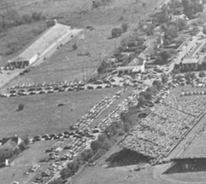
When you see aerial views of the SMU campus, they’re usually looking to the north, toward Dallas Hall. Which is one reason this photo by ace photographer Squire Haskins is interesting. It’s also noteworthy because it shows “Trailerville,” the trailer camp set up on the campus from 1946 to 1953 for married war-vet students, and it also shows the pre-fab men’s dormitories, which look like army barracks. Housing in post-WWII Dallas was was very, very tight, and people had to make do and were crammed into all sorts of spaces. (See a very large image of this photo on the UTA website here.)
For reference, Mockingbird Lane is running horizontally at the top (I was wondering if that might have been the Mrs. Baird’s bakery (built in 1953) at the top left, but it’s not far enough east), Bishop Blvd. is in the center, and Hillcrest Avenue is at the right. And there’s also a whole lot of empty land — a startling sight if you’ve seen the present-day bursting-at-the-seams campus.
Here are a few blurry close-ups. First, Trailerville (which I’ve been meaning to write about for years!) — just northeast of Ownby Stadium:

Men’s dorms in temporary buildings which were removed in 1952/53:

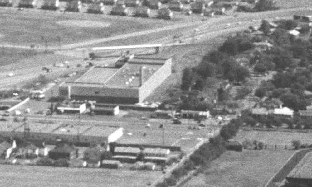
And something that isn’t the Mrs. Baird’s Bread factory (scroll down to see what it was):
*
Thanks to the comments below by reader “Not Bob,” it appears that the photo of the long building at the top left corner — on the site later occupied by Mrs. Baird’s Bread — was once an armory for the 112th Cavalry (Troop A) of the Texas National Guard. The building was originally built in 1921 as the headquarters of the Wharton Motor Company, a short-lived automobile and tractor manufacturer. It appears to have closed by 1922 and the company was bankrupt by 1924. The 112th Cavalry (with about 40 horses) moved in at the end of 1927 — they were forced to move out by the end of 1930 because of neighbor complaints (and a lawsuit) about the horses being in such close proximity to residences. By the time of the photo above, it was the Town and Country food business which rented freezer-locker space to the public. Mrs. Baird’s Bread decided to build on the site in 1949 (with the intention, presumably, to raze the existing building) — construction began in 1952 and the factory opened in 1953 (incidentally, the factory was designed by legendary Dallas architect George Dahl). (I should write about the Wharton building sometime — it has an interesting history.)
The commenter (“Not Bob”) also linked to a similar view of the campus in 1955, post-Trailerville:

By then, Central Expressway had been built and Mrs. Baird’s was cranking out that delicious aroma that filled the neighborhood for decades:
***
Sources & Notes
“Aerial view of the campus of Southern Methodist University, Dallas, Texas” is by Squire Haskins, from the Squire Haskins Photography Inc. Collection, University of Texas at Arlington Libraries; more information on this photo can be found here (click thumbnail photo to see larger image).
“1955 aerial view of campus from the north” — by William J. Davis — is from the collection of the DeGolyer Library, Southern Methodist University; more information on this photo is here.

*
Copyright © 2021 Paula Bosse. All Rights Reserved.

Looks like that building may be a little east of where the bread plant was. You can see the bread plant is closer to the houses on Airline in this 1955 oblique aerial:
https://digitalcollections.smu.edu/digital/collection/bim/id/306
It looks like the building was there as early as 1930. You can see it in this 1930 vertical aerial:
https://digitalcollections.smu.edu/digital/collection/dmp/id/56
And based on the 1930 directory I am pretty sure it was a Texas National Guard Armory at that time:
https://texashistory.unt.edu/ark:/67531/metapth806919/m1/2320/
But by the time of the photo you posted here it was no longer listed in the directory:
https://texashistory.unt.edu/ark:/67531/metapth806908/m1/3151/
LikeLike
Thanks for the tip about the armory. It looks like it was originally built in 1921 as the HQ of the Wharton Motor Co., a short-lived car manufacturer. I’ve updated the post. Thanks again!
LikeLike
That’s cool. I have never heard of Wharton. Thanks for another great post!
LikeLiked by 1 person
I bet Doak Walker didn’t live in one of those trailers and probably drove a new 1946 Ford.
LikeLiked by 2 people
I thought a Texas-built car called Wharton sounded, well, implausible. But I opened G. N. Georgano’s The new encyclopedia of motorcars and there on page 663 was the Wharton Motors Company of Dallas, Texas. They had a fairly broad plan of manufacture, but the only car actually made for sale was a large one powered by a Curtiss OX5 engine–an airplane engine of 90 hp.
Just a few were sold and none evidently survive. The problem of dipping into reference works at random is that the gems in the A’s and B’s, along with the items at the end of the alphabet get overlooked. Let this be a lesson to you.
LikeLiked by 2 people
I wonder what happened to the eastside stands for Ownby Stadium in “Not Bob’s” 1955 photo? They’re gone. Had SMU moved its games to Cotton Bowl Stadium by then? It looks like in the 1940s photo on top, there is a game underway.
LikeLiked by 1 person
Not sure of the date SMU football moved to the Cotton Bowl, but certainly before 1955. In the Doak Walker era?
LikeLiked by 1 person
According to Wikipedia, which I should have checked before the first comment, SMU moved all of its home games permanently to the Cotton Bowl from Ownby Stadium in 1948 (yes, Doak Walker! Probably wanting the huge crowds the Cotton Bowl would hold, twice the size of Ownby at the time). They had played games here and there at Cotton Bowl Stadium starting in either 1932.
LikeLiked by 1 person
Sorry, that was me commenting. Somehow I wasn’t signed in. Thanks for the correspondence, as it sent me further into the history! Of course, SMU would move games from the Cotton Bowl to Texas Stadium in the last half of the 1970s under Ron Meyer, then back to Ownby after returning from the NCAA’s “death penalty,” with later more occasional games at Cotton Bowl Stadium, then permanently into Gerald J. Ford Stadium built on the Ownby site.
LikeLiked by 1 person
[…] “SMU CAMPUS, AN AERIAL VIEW FROM THE NORTH — 1940s” […]
LikeLike
I was born in 1948 in Elm Thicket which was around the Lovefield Airport. Do you have any documents in that area in that era? I lived on Thurman street but it appears it doesn’t exist anymore.
LikeLike