Flashback : Dallas

A Miscellany: History, Ads, Pop Culture

Category: 1900s

Our Lady of Good Counsel, Oak Cliff — 1901-1961

our-lady-of-good-counsel_1944-yrbkOur Lady of Good Counsel, 1944… (click for larger image)

by Paula Bosse

Talking to my aunt today reminded me that she briefly attended Our Lady of Good Counsel, the all-girls Catholic high school in Oak Cliff next to the Church of the Blessed Sacrament, at the northwest corner of North Marsalis (originally named Grand Avenue) and 9th Street. I’m still not sure why she went there (our family isn’t Catholic), but she seems to have enjoyed her time there for a year or two before she transferred to Crozier Tech.

The school building was the former palatial home of wealthy businessman James T. Dargan, a one-time partner of Thomas L. Marsalis. The house was built about 1888, and according to Dallas Rediscovered author William L. McDonald, it was designed by the Dallas architectural firm of Stewart and Fuller.

dargan_1889-directory1889 Dallas directory

The church was holding services in Oak Cliff as early as 1901, and an affiliated school was established by Rev. Francis P. Maginn in September of that year. It appears that the Dargan house was acquired in 1902, the same year that the (new?) church building was dedicated in ceremonies officiated by Bishop E. J. Dunne.

Below, the new church can be seen in a photo which appeared in The Dallas Morning News on the day of its dedication in June, 1902 (all images are larger when clicked):

church-of-blessed-sacrament_dmn_061502_photoDMN, June 15, 1902

The neighboring school can be seen in these two early photos:

OLGC_ad_dallas-history-guild
Our Lady of Good Counsel, ca. 1902

our-lady-of-good-counsel_ca-1905_dallas-rediscovered
Our Lady of Good Counsel, ca. 1905

The school’s founder, Rev. F. P. Maginn:

maginn-francis-p_dmn_061502_church-of-blessed-sacrament
DMN, June 15, 1902

OLGC_dmn_042302DMN, April 23, 1902

And an early ad for the school, from 1903 (“Discipline mild, yet firm”):

our-lady-of-good-counsel_1903-ad
1903

Here it is in 1942:

our-lady-of-good-counsel_1942-yrbk

And here are some of the LGC high school students from 1944, looking bobby-soxer-y (with another view of the augmented house in the lower left corner):

our-lady-of-good-counsel_1944-yrbk_candids

The newest additions to the building can be seen in the 1959 yearbook:

our-lady-of-good-counsel_1959-yrbk

In 1961, Our Lady of Good Counsel was a fast-fading memory: a new 32-acre campus had been acquired and on it had been built the new (coed) Bishop Dunne High School. Mr. Dargan’s old house-turned-school-building was torn down a few years later, and the land became a parking lot for the Blessed Sacrament church next door (which had also seen many changes and a new building over the years). Today, the view of the land the Dargan house sat on 130 years ago looks like this. (The church looks like this.)

The church in 1930:

church-of-blessed-sacrament_1930

And in 1958 (from the LGC yearbook):

blessed-sacrament-church_OLGC-yrbk_1958

This visual aid will help give an idea of the acreage of both the school (circled in red) and the church (circled in blue), via the 1905 Sanborn map:

OLGC_sanborn_dallas-1905_sheet-171

I’m still not sure why my aunt went there….

OLGC_address_1958
1958

UPDATE: For those who might have wanted to see some interior photos, I didn’t find many, other than typical classroom shots, but here are some additional photos, a couple of which show the hallway.

Between classes, 1959:

OLGC_1959-yrbk_hallway

Girls lining up to go into class, 1960:

OLGC_1960-yrbk_hallway

Girls outside playing volleyball, 1960:

OLGC_1960-yrbk_volleyball

I had erroneously assumed that LGC was an all-girls 4-year high school; I believe it was a 12-year school, with boys and girls up to high school level, when it became girls-only. This photo appeared in the 1960 yearbook with the following caption: “The safety of all LGC students is the responsibility of the school as long as the students are on campus. For this reason, Officer H. A. Baxtley is available every day as a gracious escort for our little ‘Lions’ across the busy Ninth and Marsalis intersection.”

OLGC_1960-yrbk_crossing-guard

And finally, because I’m such a movie nerd who loves character actors, I was happily surprised to see that the actress K Callan was a 23-year-old drama teacher (etc.) at the school in 1959 before she entered the professional acting world of New York and Hollywood. (Callan was born in Dallas as Katherine “Kay” Borman and actually attended Our Lady of Good Counsel as a student before she taught there.) (UPDATE: Read K’s memories of her time at LGC in the comments, here.)

callan-k_our-lady-of-good-counsel_1959-yrbk_drama-teacher

callan-k_our-lady-of-good-counsel_1959-yrbk_drama-teacher_b

***

Sources & Notes

All photos of the school (except the one from 1905) are from various editions of Reveries, the yearbook for Our Lady of Good Counsel.

The 1902 photo was posted in the Dallas History Guild Facebook group.

The 1905 photo is from Dallas Rediscovered by William L. McDonald (p. 215), with the following credit: “Courtesy of Sister M. Adelaide Mars.”

The Blessed Sacrament Catholic Church still stands, at 231 N. Marsalis; their website is here.

olgc_1942-yrbk_girls_sign
1942

*

Copyright © 2017 Paula Bosse. All Rights Reserved.

The Gill Well

gill-well_highland-park_dallas-rediscoveredThe Highland Park pagoda… (click for larger image)

by Paula Bosse

I never heard of the Gill Well growing up — in fact, it wasn’t until around the time I started this blog — about three or four years ago — that I first became aware of it. Though largely forgotten today, the Gill Well used to be a pretty big deal in Dallas: for years, early-20th-century entrepreneurs tried valiantly and persistently to capitalize on the mineral-heavy artesian water from this well — the plan was to use this hot spring water in order to turn Dallas (or at least Oak Lawn) into, well, “the Hot Springs of Texas.” We came so close!

So — Gill Well? Who, what, when, where, why, and how?

In 1902 city alderman and water commissioner C. A. Gill proposed sinking an artesian well near the Turtle Creek pumping station in order to determine if the flow of water in underground springs was sufficient to augment Dallas’ water supply (there was, at the time, another such test well being drilled in West Dallas). The City Council was on board and wanted this test well to be a deep well, “the deepest in the state — in order to settle once and for all the question as to whether or not there lies beneath the earth in this section a body of water, or ‘an underground sea,’ as some call it, of sufficient size to supply the needs of all the people” (Dallas Morning News, Aug. 6, 1902).

Fellow alderman Charles Morgan explained Gill’s proposition to the people of Dallas in a prepared statement to the Morning News:

By sinking artesian wells it is not intended to abandon the plans proposed to secure an adequate storage supply from surface drainage, but that the artesian wells shall augment the supply. We can not get too much water, but if we secure an ample artesian supply our storage basins will be reserve. There will be no conflict. We simply make success double sure. (Alderman Charles Morgan, DMN, Aug. 24, 1902)

The well was sunk in September or October of 1902 near the Turtle Creek pumphouse (which was adjacent to where a later station was built in 1913, the station which has been renovated and is now known as the Sammons Center for the Arts — more on the construction of that 1913 station and a photo of the older pumphouse can be found here); the drilling was slow-going and went on until at least 1904, reaching a depth of more than 2,500 feet. It’s a bit out of my area of expertise, but, basically, good, palatable artesian water from the Paluxy sands — water “free from mineral taint” — was found, but, deeper, a larger reservoir of highly mineralized “Gill water” — from the Glen Rose stratum — was found. That was good news and bad news.

gill-well_dmn_120103
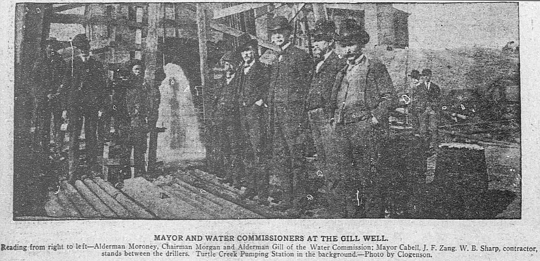
Dallas Morning News, Dec. 1, 1903

The “bad news” came from the fact that a part of a pipe casing became lodged in the well, causing an obstruction in the flow of the “good” water from the Paluxy formation. Again, it’s a bit confusing, but the heavy flow of 99-degree-fahrenheit mineral water (which was corrosive to pipes) threatened to contaminate the “good” Paluxy water … as well as the water from the Woodbine formation from which most (all?) of the private wells in Dallas secured their water. (Read detailed geological reports on the well in a PDF containing contemporaneous newspaper reports here — particular notice should be paid to the comprehensive overview of the well and its problems which was prepared for the Dallas Water Commission by Engineer Jay E. Bacon and published in the city’s newspapers on May 10, 1905).

So what the City of Dallas ended up with as a result of this Gill Well was a highly dependable source of hot mineral water. But what to do with it? Monetize it!

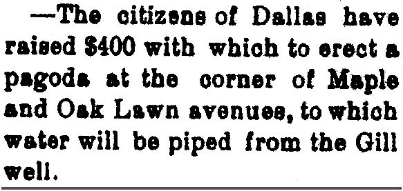
As part of the city’s water supply, the mineral water was made available to Dallas citizens free of charge: just show up at one of the handful of pagoda-covered dispensing stations with a jar, a bucket, or a flask, and fill up with as much of the rather unpleasant-smelling (and apparently quite powerful!) purgative as you could cart home with you. (For those who didn’t want to mingle with the hoi polloi, home delivery was available for a small fee.) One such “pagoda” was erected a short distance away, in front of the city hospital (Old Parkland) at Maple and Oak Lawn (the healthful water was also piped directly into the hospital for patient use).

gill-well-parkland-pagoda_brenham-weekly-banner_040605
Brenham Weekly Banner, April 6, 1905

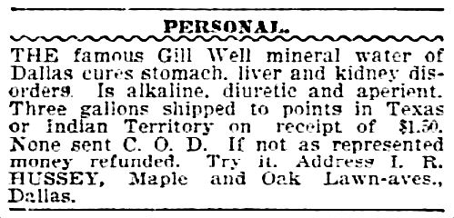
One man, however, began offering the water for sale beyond Dallas, hoping to cash in on the free-flowing tonic (see the mineral-content breakdown here), but the city clamped down on him pretty quickly as he was not an authorized agent. From his 1906 ad, one can see that the reputation of Gill water and its healing and restorative powers was already widely known.

gill-well-water_dmn_080206
DMN, Aug. 2, 1906

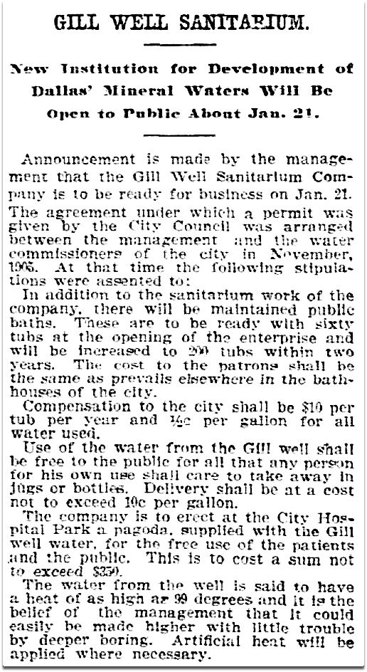
If the water was not to be sold, what was the City of Dallas going to do with it? It was decided to pipe the the water a short distance from the test well to nearby property adjacent to the land now occupied by Reverchon Park, then lease the access to the water to a capitalist who would build a sanitarium/spa where people could come to “take the waters” — to bathe in the naturally warm, mineral-heavy artesian water with mystical recuperative properties. The sanitarium would make money by charging its patrons for its services, and the city would collect a small annual income based on the number of the sanitarium’s bathing tubs and the amount of water used:

Compensation to the city shall be $10 per tub per year and one-half-cent per gallon for all water used. (DMN, Jan. 4, 1907)

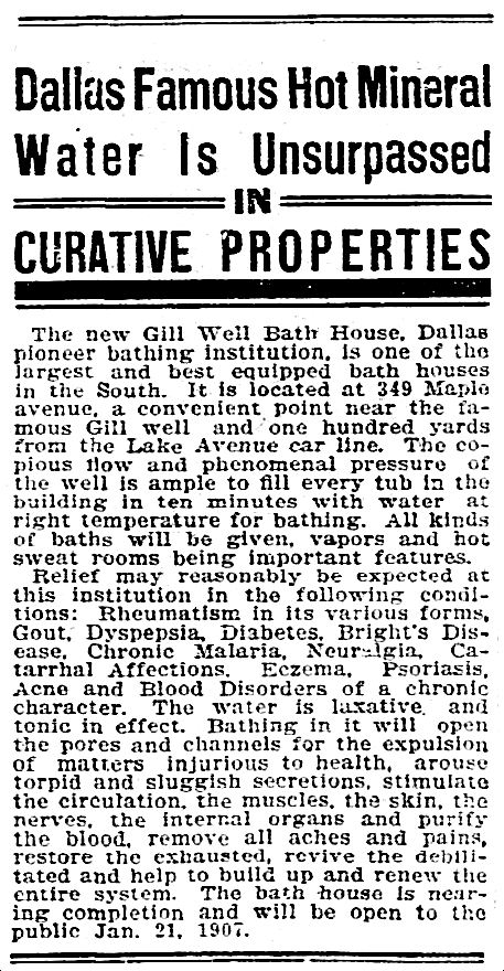
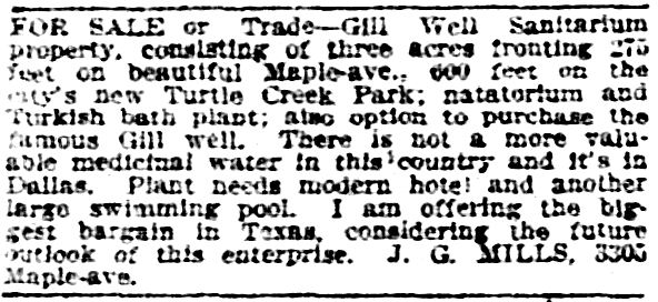
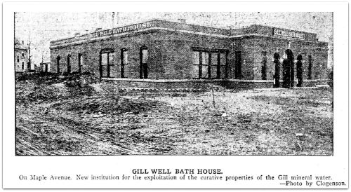
The Gill Well Sanitarium and bath house opened in January 1907, on Maple Avenue just north of the MKT Railroad (now the Katy Trail). (Most clippings and pictures in this post are larger when clicked.)

gill-well-sanitarium_dmn_010407DMN, Jan. 4, 1907

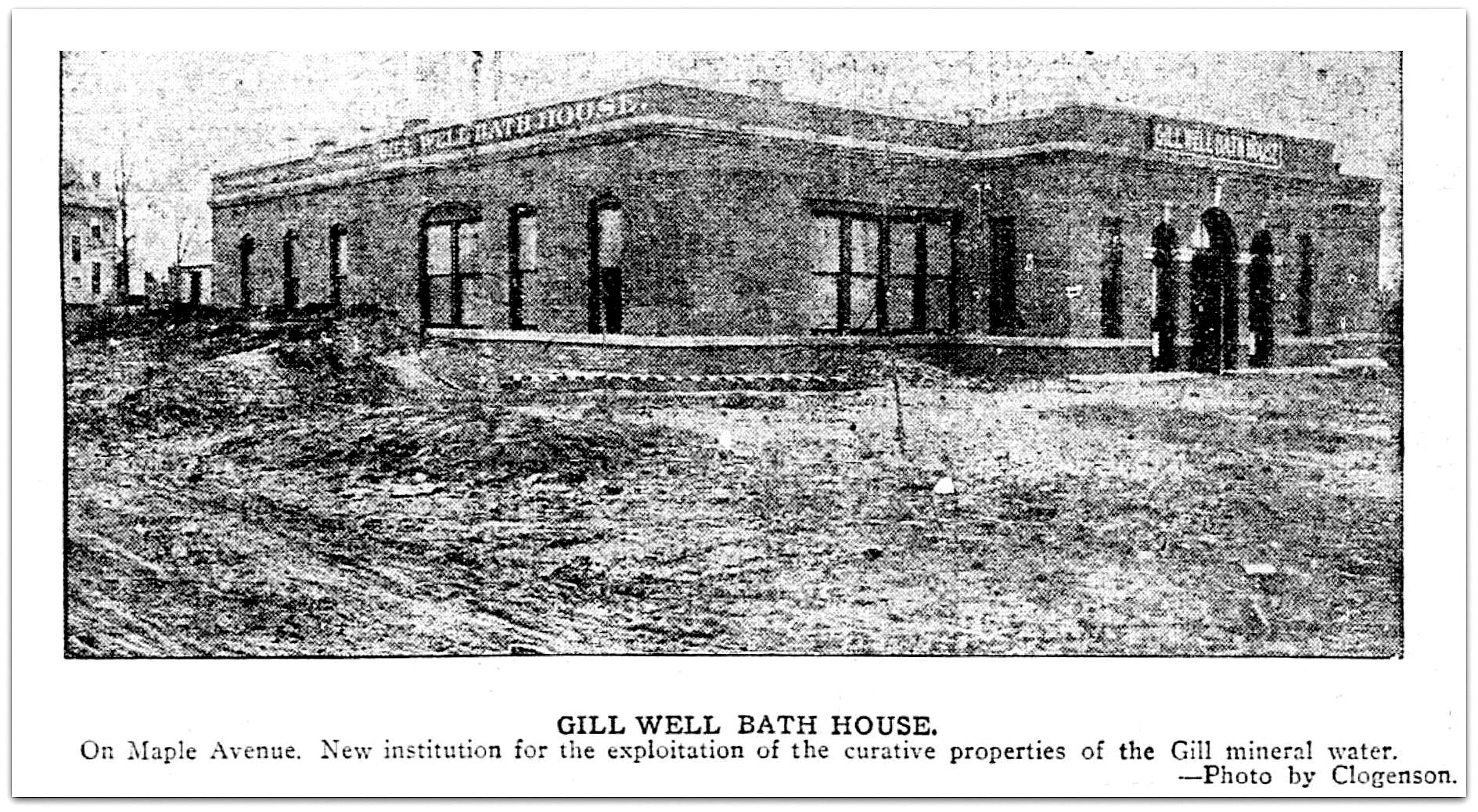
I searched and searched and searched for a picture of the building and, hallelujah, I finally found one, in the pages of The Dallas Morning News, taken by photographer Henry Clogenson. (This is the only picture I’ve been able to find of it, and, I have to say, it’s not at all what I expected the building to look like. It actually looks like something you’d see in a present-day strip mall.)

gill-well-sanitarium_dmn_011307_photoDMN, Jan. 13, 1907

gill-well-sanitarium_dmn_010607_ad
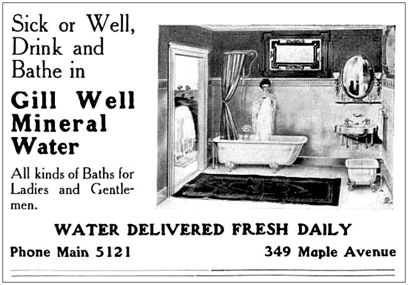
Advertisement, DMN, Jan. 6, 1907

Business at the new sanitarium was very good, and the public fountains/spigots at both the sanitarium property and a block or so away at the city hospital continued to be popular with residents who needed a boost or a “cure” and stopped by regularly for a sip or a pail of the free mineral water.

gill-well_ad_dallas-police-dept-bk_1910_portal1910 ad

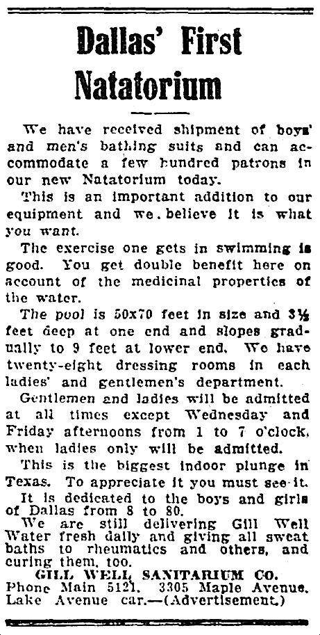
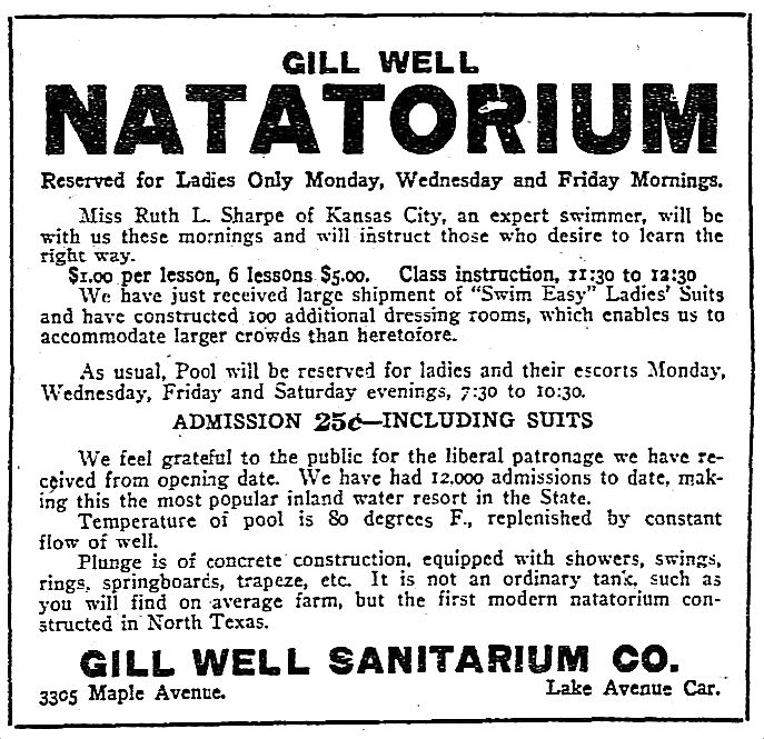
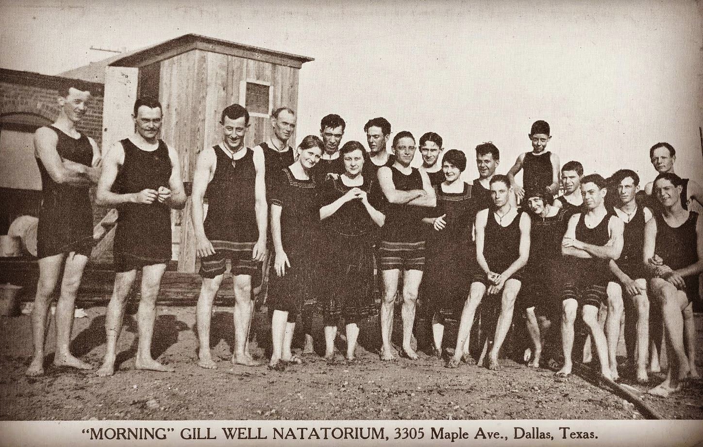
In 1912 a natatorium (an indoor swimming pool) was added and proved even more popular. It was open to men, women, and children; admittance and bathing suit rental was 25¢ (about $6.50 in today’s money). (Contrary to the headline of the ad below, it was not Dallas’ first natatorium — there was one near City Park on South Ervay by at least 1890 — but it was probably the first pool in the city filled with warm mineral water.)

gill-well_natatorium_dmn_041412
DMN, April 14, 1912

gill-well-natatorium_dmn_070712
DMN, July 7, 1912

gill-well-natatorium_texas-swimming-and-diving-hall-of-fameCourtesy of the Texas Swimming and Diving Hall of Fame
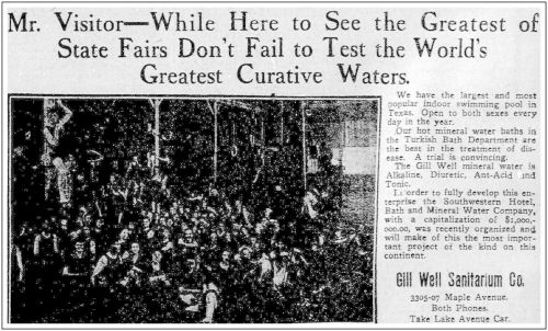
gill-well-natatorium_dmn_100612DMN, Oct. 6, 1912

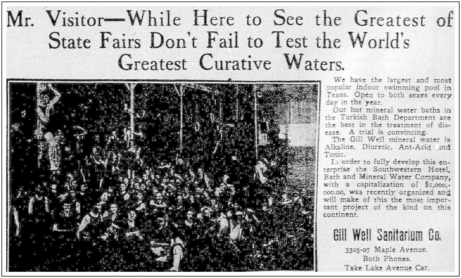
The last paragraph of the ad above mentions a plan to pipe Gill water to a hotel downtown — not only would the Gill Well Sanitarium Company’s services be offered in the heart of the city amidst lavish hotel surroundings (instead of in Oak Lawn, way on the edge of town), but the company would also be able to compete with Dallas’ other (non mineral-water) Turkish baths — then they’d really be rolling in the cash. As far as I can tell, nothing came of the plan, but the men behind it were pretty gung ho, as can be seen in this rather aggressive advertorial from the same year:

ad-sanitorium-baths_blue-bk_1912The Standard Blue Book of Texas, 1912

All seemed to be going well with the sanitarium until the city and the Missouri, Kansas & Texas Railroad (the MKT, or the Katy) decided to remove the railroad’s grade crossings through the Oak Lawn area (all work which was to be paid for by the railroad). Double tracks were to be added and crossings were either raised or the streets were lowered. The crossings affected were Lemmon, Cedar Springs and Fairmount (where street levels were cut down to go under the tracks) and Hall, Blackburn, and Bowen (where tracks would be elevated). Also affected: Maple Avenue. (Read more about the MKT plan in the Dallas Morning News article from Aug. 23, 1918 — “Dallas Is Eliminating Four Grade Crossings” — here.)

The Maple Avenue-Katy Railroad crossing had long been a dangerous area for wagons, buggies, and, later, automobiles. Not only was it at the top of a very steep hill (see what that general area north of that crossing looked like around 1900 here), but it also had two sharp curves. The decision was made to straighten Maple Avenue between the approach to the railroad crossing and Oak Lawn Avenue at the same time Maple was being lowered and the Katy track was being raised. (Read the announcement of this plan — “Straighten Maple Avenue Is Plan” — from the Nov. 29, 1917 edition of The Dallas Morning News, here.) The only problem — as far as the Gill Well Sanitarium was concerned — was that the straightened road would go directly through the sanitarium property. I don’t know if the long-time owner of the sanitarium, J. G. Mills, knew about this approaching dire situation, but in 1915 — just a few short months after boasting in advertisements that more than 50,000 patients had availed themselves of the sanitarium’s amenities in 1914 — he placed an ad seeking a buyer of the business (although, to be fair, he’d been trying to sell the company for years):

gill-well_dmn_080815_for-saleDMN, Aug. 8, 1915

(In the ad he states that the buyer had an option to purchase the actual well, but the city had never expressed any desire to sell either the well or the full rights to the water.)

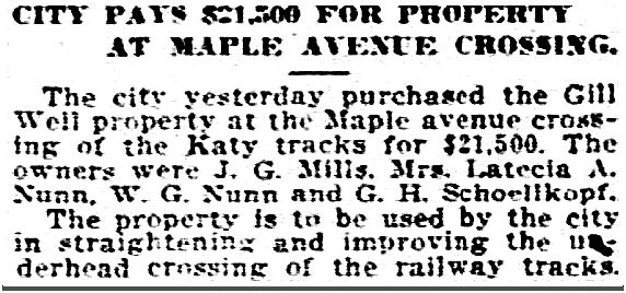
The Gill Well Sanitarium Co. appears to have been dissolved in 1916, but there was still hope that a sanitarium/hot springs resort could continue on the property. In 1917, interested parties petitioned the city to change its plans to straighten Maple, arguing that it would destroy any ability to do business on the site, but the city went forward with its plans, and in November 1919, the City of Dallas purchased the land from the group of partners for $21,500 (about $305,000 in today’s money).

gill-well_dmn_111319
DMN, Nov. 13, 1919

The monetization of water from Dallas’ fabled Gill Well ended after ten years.

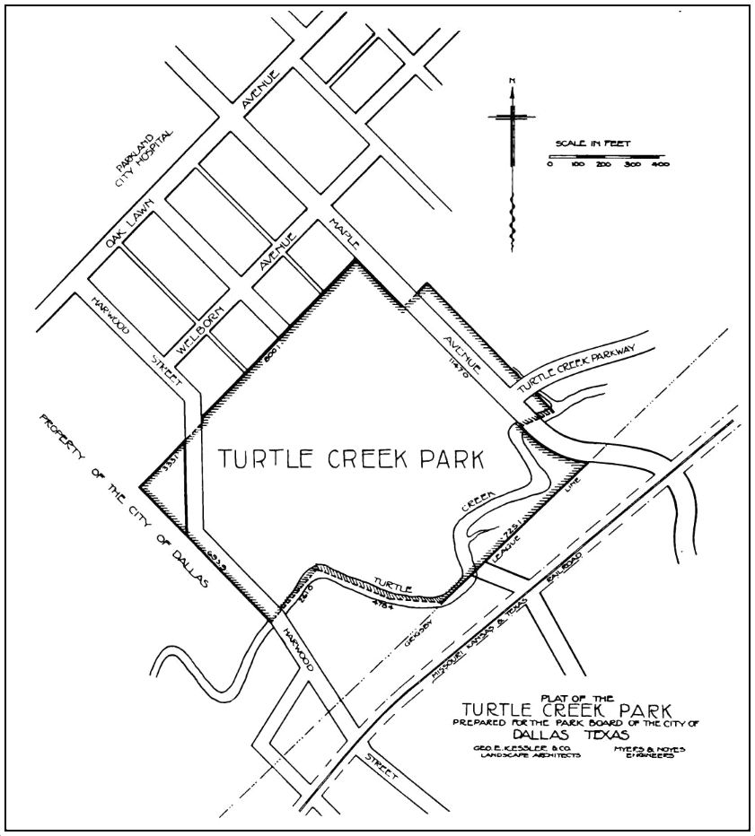
I had never heard of Maple Avenue being straightened. Below is a map of Turtle Creek Park (which became Reverchon Park in 1915), showing Maple’s route, pre-straightening — the main buildings of the sanitarium were in the bulge just west of Maple, between the Katy tracks and the boundary of the park.

reverchon-park_turtle-creek-park_map_1914-15
1915 map, via Portal to Texas History

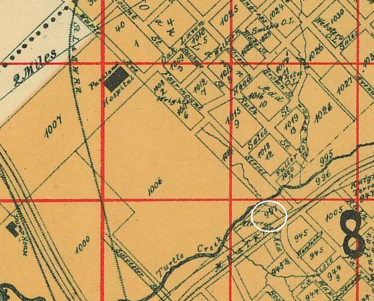
Another view can be seen in a detail from a (fantastic) 1905 map, with the approximate location of the Gill Well Sanitarium circled in white:

maple-ave_1905-map_portal_det_gill-wellWorley’s Map of Greater Dallas, 1905

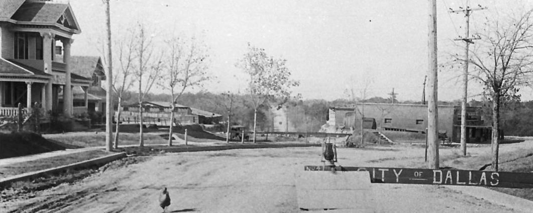
A year or more ago I saw the photo below on the Big D History Facebook page but had no idea at the time what I was looking at: it apparently shows Maple Avenue in 1918, taken from about Wolf Street (probably more like Kittrell Street), which was then near the city limits, looking north. You can see the curve Maple makes and the steep hill — that large building at the right must be the sanitarium and/or the later-built natatorium.

maple-ave_road-construction_from-wolf_1918_big-d-history-FB

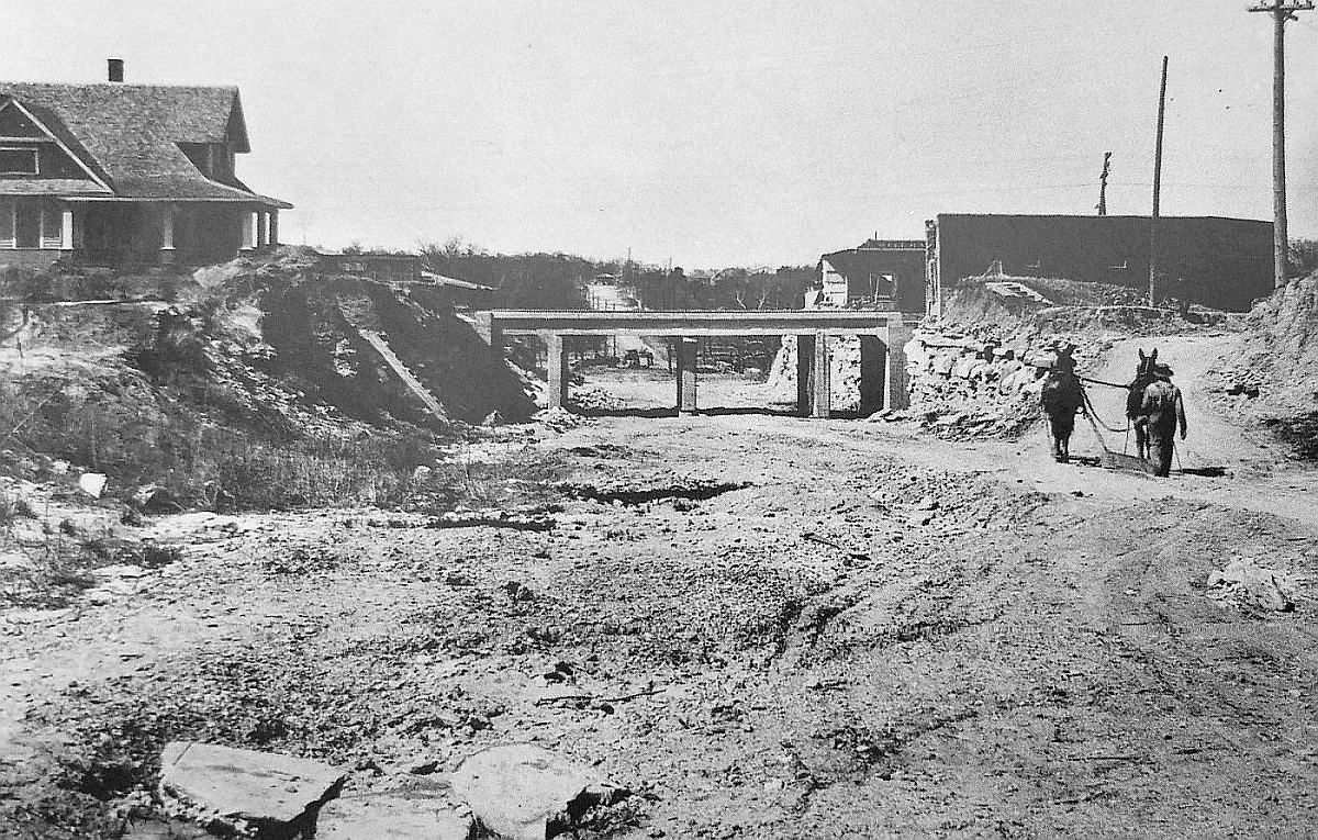
The photo below shows the road-straightening in progress, with the MKT bridge now spanning Maple Avenue.

maple-MKT_ca-1920_DPLDallas Public Library

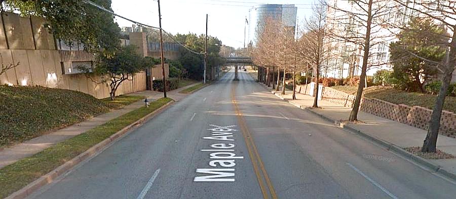
And here it is almost a hundred years later:

maple-MKT_google-street-view_2014Google Street View, 2014

So the Gill Well Sanitarium and Bath House was closed, the land was purchased by the City of Dallas, Maple Avenue was straightened, and, in the summer of 1923, the remaining abandoned buildings on the property were demolished. But that didn’t spell the end of the famous Gill Well water.

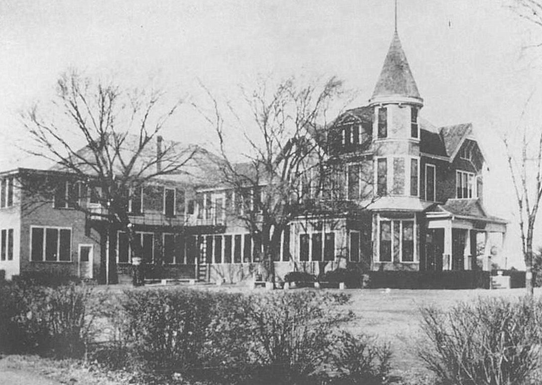
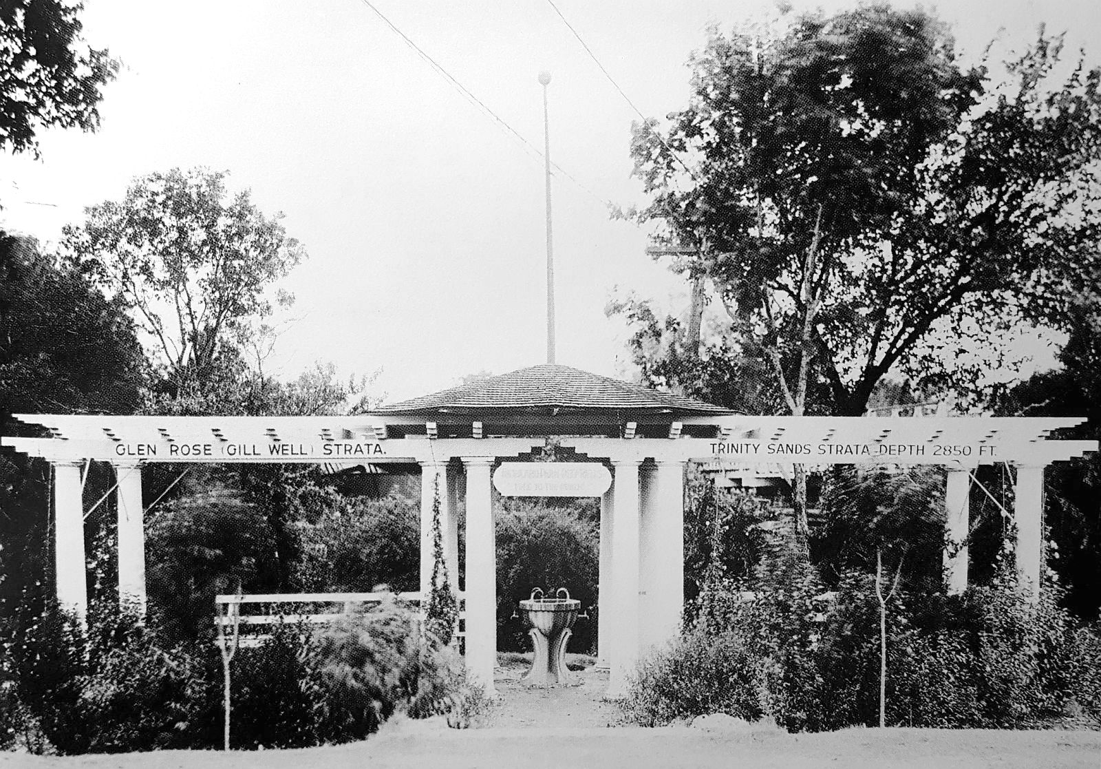
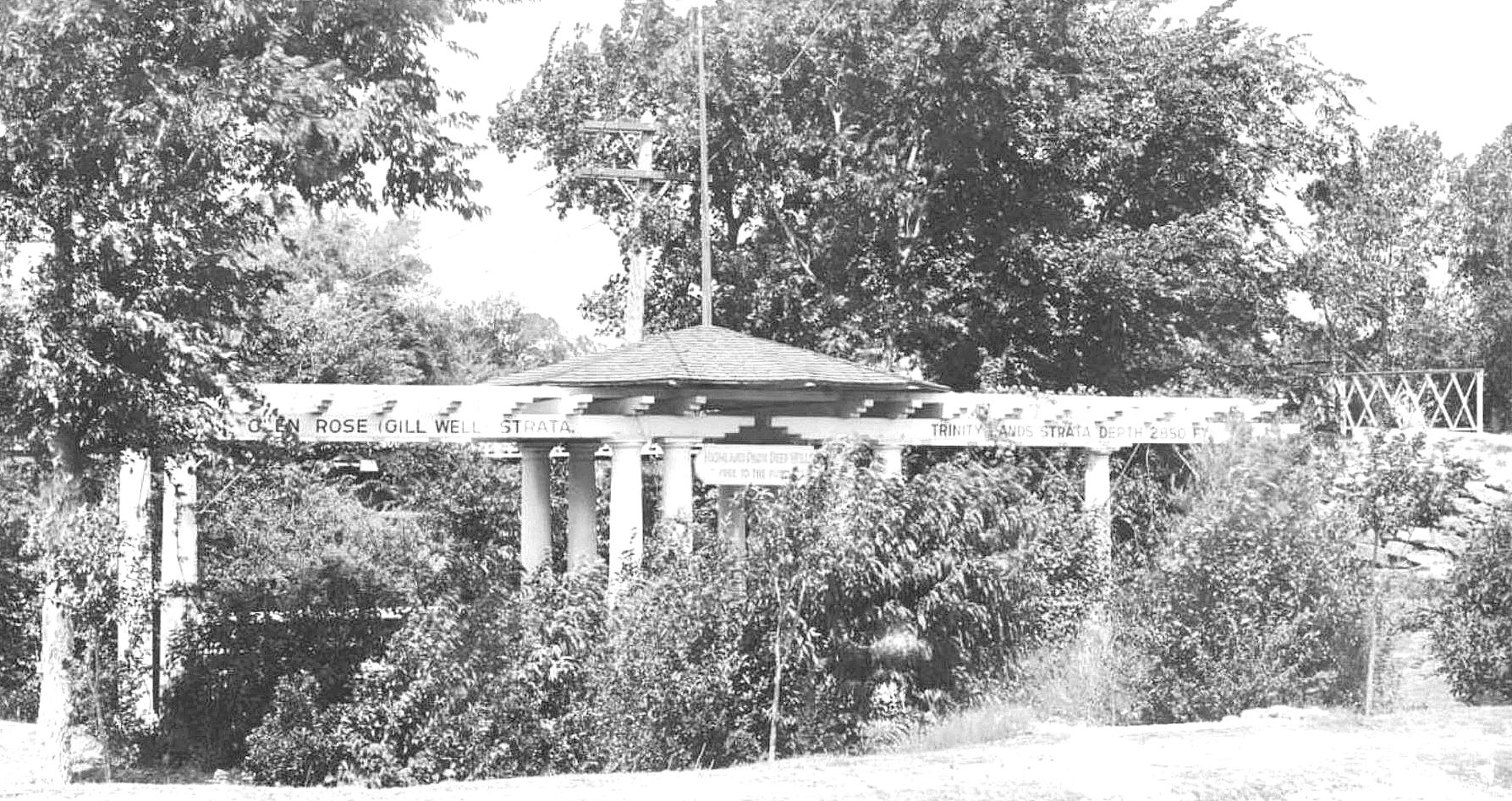
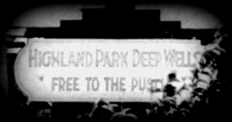
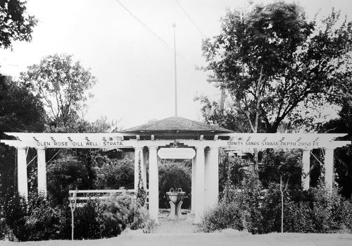
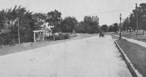
Highland Park’s “Gill Water” Pagoda

Around 1924, “Gill water” tapped from the Glen Rose Strata was made available to Highland Park, via a small “watering house” and drinking fountain on Lakeside Drive (at Lexington), a location which proved to be quite popular. The mineral water was a byproduct of Highland Park’s “deep well” which was drilled in 1924 to tap the pure artesian springs of the Trinity Sands Strata in order to augment the water supply of the City of Highland Park: in order to get down to the Trinity Sands, one had to pass through the Glen Rose Strata — I guess the HP powers-that-be figured they might as well tap the hot mineral water and offer their citizens access to it by building a small fountain and dispensing station. In 1928, the little “watering station” structure was spiffed up with the addition of a tile roof, attractive walkways, and drainage. The photo seen at the top of this post has frequently been misidentified as the Reverchon Park well, but it is actually the Highland Park “pagoda.” Here it is again:

gill-well_highland-park_dallas-rediscoveredfrom the book Dallas Rediscovered

It can be identified as the Highland Park location because of the photo below from the George W. Cook collection of historic Dallas photos from SMU’s DeGolyer Library — it shows what appears to be a later view of the same pagoda, now slightly overgrown. The steps to the bridge across Exall Lake and the bridge’s railing can be seen at the far right (the bridge led to the Highland Park pumping station, which can be seen on a pre-watering-station 1921 Sanborn map here).

gill-well_highland-park_cook-collection_degolyer_smuGeorge W. Cook Collection, SMU

And, well, there’s the sign that reads “Highland Park Deep Wells — Free to the Public” — here’s a close-up:

gill-well_highland-park_cook-collection_degolyer_smu_det

(The same sign from the top photo can be seen in a high-contrast close-up here.)

After seeing this photo, I realized that a photo I featured in a post from last year showed the pagoda in what looks like its earliest days, at Lakeside Drive and Lexington Avenue (the bridge can be seen at the left):

hp_lakeside-drive_rppc_ebayeBay

I was unable to find out when this HP pagoda bit the dust, but the location as seen today on Google Street View is here. (It’s pretty strange to think that a steady stream of people from all over Dallas drove to the Park Cities to fill up jugs with free mineral water; my guess is that the wealthy Lakeside Avenue residents weren’t completely enamored of the situation.)

Reverchon Park Pavilion

Even though the Gill Well Sanitarium Co. had dissolved in 1916, and the last traces of its buildings had been torn down in 1923, the famed well’s water didn’t disappear from the immediate Oak Lawn area. In February of 1925, the City of Dallas opened a $5,000 pavilion, “making up for twenty years indifference to what is said to be the finest medicinal water in the South” (DMN, Feb. 11, 1925). This pet project of Mayor Louis Blaylock seems to have continued to be a place for Dallasites to get their mineral water at least through the 1950s, according to online reminiscences. This 1925 “pavilion” is described thusly in the WPA Dallas Guide and History:

The water, which resembles in many respects the mineral waters of European resorts and is used in several county and city institutions, is carried to the surface in pipes and can be drawn from taps arranged around a semicircle of masonry near the entrance to the park. Here cars stop at all hours of the day and people alight to drink the water or to fill bottles and pails.

I have not been able to find a photograph of that post-sanitarium dispensing site. A 1956-ish aerial photo of Reverchon Park can be found here. I don’t see a “semicircle of masonry” in an area I assume would be located near Maple Avenue and the Katy tracks.

According to a comment on the DHS Archives Phorum discussion group, there was also a public spigot nearer to the original well, along Oak Lawn Avenue, across the street from Dal-Hi/P. C. Cobb stadium.

There is surprisingly little accurate information on the Gill Well online. I hope this overview helps correct some of the misinformation out there. If anyone knows of additional photos of the sanitarium and/or natatorium, please send them my way and I’ll add them to this post. If there are any photos of the Reverchon Park pavilion, I’d love to see those as well. There is a 1926 photo of the Highland Park location which shows two women and two girls filling receptacles — I am unable to post that here, but check the Dallas Morning News archives for the short article “Free Mineral Well Waters Popular” (DMN, May 29, 1926).

**

Incidentally, even though the wells have been capped, that hot mineral water is still there underground and could be tapped at any time. Dallas could still be the “Hot Springs of Texas”!

***

Sources & Notes

Top photo is from p. 199 of Dallas Rediscovered by William L. McDonald. The photo is incorrectly captioned as showing the location of the “Gill Well Bath House and Natatorium, c. 1904” — it is actually the Highland Park dispensing station at Lakeside Drive and Lexington Avenue in about 1928.

“Morning” postcard featuring healthy bathing patrons of the natatorium is from the collection of the Texas Swimming and Diving Hall of Fame and is used with permission.

Photo showing Maple Avenue, pre-straightening, is from the Big D History Facebook page; original source of photo is unknown.

Second photo of the Highland Park Gill Well location (with the vegetation looking a bit more overgrown) is from a postcard captioned “Drinking Bogoda [sic], deep mineral well in Highland Park, Dallas, Texas” — it is from the George W. Cook Dallas/Texas Image Collection, DeGolyer Library, Central University Libraries, Southern Methodist University; more information on this image is here.

Photo showing Lakeside Drive with the pagoda at the left is a real photo postcard captioned “Lake Side Drive in Highland Park” — it was offered last year on eBay.

Sources of all other clippings, ads, and maps as noted.

*

Copyright © 2017 Paula Bosse. All Rights Reserved.

The Mosquito Bar

sargent_mosquito-nets_1908Relax without fear of being bitten by mosquitoes…

by Paula Bosse

The “mosquito bar” — the human’s defense against blood-thirsty mosquitoes (and other annoying pests) — had its heyday in the US in the second half of the 19th century and the first couple of decades of the 20th century, before screens for windows and doors were commonplace in American homes. They were particularly necessary in the hot and sweaty Southern US states which were routinely plagued with mosquitoes. A typical mosquito bar ad looked like this one from Dallas merchants Sanger Bros. (click ads and clippings to see larger images):

mosquito-bar_dallas-herald_080285_sanger-bros-ad-det
Dallas Herald, Aug. 2, 1885

(According to the Inflation Calculator, $1.00 in 1885 money would be worth about $27.00 in today’s money, adjusted for inflation.)

The first Dallas ad I found for mosquito bars was from 1877 — like the clipping above, it is also from a Sanger Bros. ad (in fact, Sanger’s seemed to be mosquito-bar-central for 19th-century Dallas).

mosquito-bar_sanger-bros-ad-det_dallas-herald_073177
Dallas Herald, July 31, 1877

mosquito-bar_sanger-bros-ad-det_dallas-herald_051478
Dallas Herald, May 14, 1878

mosquito-bar_screens_dallas-herald_052482_sanger-bros-ad-det
Dallas Herald, May 24, 1882

mosquito-bars_southern-mercury_070390Southern Mercury, July 3, 1890

screens_dallas-screen-co_1894
1894

Mosquito bars were usually draped over beds, canopy-style, but the painting above (“Mosquito Nets” by John Singer Sargent, 1908) shows “personal” net-covered armatures, perfect for genteel ladies to relax inside of and read (while trying to keep cool despite being weighed down by what must have been uncomfortably heavy clothing).

The mesh netting or fine muslin used to drape beds (and cover windows and doors) was generally white or pink, sometimes green. Once inside the canopied beds, the netting was tucked under the mattress in order to seal all potential entry points in the mesh-walled fortress and allow the thankful occupants inside to sleep unmolested by mosquitoes (or other biting and stinging insects).

mosquito-netting

These bars became fairly standard in hotels and in many homes of the time, but if one could not afford the luxury of sleeping inside one of these things, the sleeper would often resort to rubbing him- or herself with kerosene if they wished to avoid being bitten throughout the night.

mosquito-bar_dmn_100110_kerosene
Dallas Morning News, Oct. 1, 1910

As much of a godsend as the bars were, they had their problems. The fine material was easily torn, and sometimes the mesh was so tightly knit that ventilation (and breathing!) was not optimal. Also, it was not unusual for them to catch fire — there are numerous newspaper reports of the bars being ignited by candles or gas-burning lamps or by careless or sleepy smokers smoking inside the canopy.

mosquito-bar_dallas-herald_052481_fire
Dallas Herald, May 24, 1881

It was apparently a common precaution against midnight thievery for men who stayed in hotels to keep their money in the pockets of their pants and then fold the pants and place them beneath their pillows. The second line of defense was the mosquito netting tucked resolutely under the mattress of their canopied beds. The feeling was that a burglar would have to be pretty stealthy to breech a man’s mosquito bar and steal his pants from under his pillow without waking him. But never underestimate the Big City burglar (click article to see a larger image):

mosquito-bar_dmn_091088_theft
DMN, Sept. 10, 1888

After doors and windows began to be routinely covered with wire screens, the use of mosquito bars in homes and hotels waned, but their use continued in military encampments and hospitals, in recreational camping, and in swampy or tropical areas where the transmission of diseases like malaria and Dengue fever (transmitted by mosquitoes) posed health risks. Wire screens must have been a godsend.

ad-acme-screen-co_terrill-yrbk_1924Acme Screen Co., 1924

And if you don’t think that the prospect of a night without a mosquito bar (especially in the bayous of Louisiana…) wouldn’t inflame usually calmer heads, here’s a news story from 1910 about a man who shot a co-worker three times at close range because of a heated argument over which of them owned a mosquito bar. And this was in February! Lordy. Talk about your crime of passion. The moral of this story: do not mess with another man’s mosquito bar.

mosquito-bar_town-talk_alexandria-LA_022210_deadly-dispute
Town Talk (Alexandria, LA), Feb. 22, 1910

*

mosquito-bar_dmn_052812_couplet
DMN, May 28, 1912

***

Sources & Notes

The top painting by John Singer Sargent — titled “Mosquito Nets” (1908) — is from the Detroit Institute of Arts; more on the painting can be found here.

Photo of draped bed is from the “Mosquito Net” Wikipedia page, here.

Other clippings and ads as noted. Dallas Herald and Southern Mercury newspaper scans are part of the huge database of scanned historical Texas newspapers found at the Portal to Texas History (to see newspapers, click this link and filter by “Counties,” “Decades,” “Years,” etc. on the left side of the page, or search by keywords at the top).

This post was adapted from a post I wrote for my other (non-Dallas) blog, High Shrink — that post, “The Mosquito Bar,” can be found here (it includes some great additional photographs and illustrations).

*

Copyright © 2017 Paula Bosse. All Rights Reserved.

The Swiss Avenue Car on Main Street — ca. 1900

swiss-ave-streetcar_main-and-market_cook-degolyer_c1900Main and Market, looking east…

by Paula Bosse

Here’s another great photo from the George W. Cook collection at SMU. This one shows Main Street sometime between 1899 and 1902 (the year asphalt was laid on Main and the year that Sanger Bros. expanded their building from two stories to six); we’re looking east from Market Street. (The aesthetically challenging view as seen today on Google is here.)

On the north side of Main (at the left), we can see horse-drawn wagons parked in front of a group of businesses including Konantz Saddlery Co., Ben F. Wolfe & Co. (machinery), a banner across the sidewalk for the Southwestern Electrical Engineering & Construction Co., Swope & Mangold wholesale and retail liquor company; then past Austin Street, on the corner, is the Trust Building, with the then-two-story Sanger Bros. building right next door (Sanger’s would build that up to six floors in 1902 and would eventually take over the Trust Building); across Lamar is the North Texas Building, with Charles L. Dexter’s insurance company advertised on the side; and, beyond, the Scollard Building, etc. The Windsor Hotel can be seen on the south side of the street in the foreground. And in the middle, an almost empty little streetcar with “Swiss Av.” on it, moving down Main underneath a canopy of hundreds of ugly electric wires zig-zagging overhead. Let’s zoom in around the photo to see a few closeups (all images are much larger when clicked).

Wagons parked at the curb:

swiss-car_1

*

Is that someone in the window looking down the street?

swiss-car_2

*

Swope & Mangold was one of the oldest “liquor concerns” in turn-of-the-century North Texas.

swiss-car_3

*

The electric streetcar shared the roadway with horses, buggies, and wagons.

swiss-car_4

*

I can’t quite make out the writing on the umbrella or on the sign posted on the pole. Part of the old Windsor Hotel can be seen at the right. At the bottom corner is a shop that sold “notions” and household goods, and just out of frame were a fish market and a meat market.

swiss-car_5

*

And the little Swiss Avenue car 234. Lotsa free seats.

swiss-car_4-a

*

Here’s another view of Main Street looking east, taken around the same time. There’s even a streetcar in about the same spot.

main-street-birdseye_ca-1900_dallas-rediscov_p42_DHS

*

See the 1899 Sanborn map for this general area here (note that Record Street was once Jefferson Street).

***

Sources & Notes

Top photo — titled “Main Street between Austin and Market Streets” — is from the George W. Cook Dallas/Texas Image Collection, DeGolyer Library, Central University Libraries, Southern Methodist University; more information on this photo is here.

The circa-1900 bird’s-eye view photo at the bottom is from the collection of the Dallas Historical Society, found in the book Dallas Rediscovered by William L. McDonald (p. 42).

*

Copyright © 2017 Paula Bosse. All Rights Reserved.

San Antonio Extra: The Texas Transportation Co. and the Pearl Brewery Electric Freight Trolley

texas-transportation-co_cook-coll_degolyer_smu_san-antonioT. T. Co. No. 1, at your service… (click for larger image)

by Paula Bosse

I come across a lot of interesting Texas photos that have nothing to do with Dallas, so I think I might, on occasion, post them here, knowing that someone else is also likely to find them interesting. Like the one above.

This photo is from the incredible gift that just keeps giving, the George W. Cook Dallas/Texas Image Collection, held by the DeGolyer Library at SMU. Most of the items in the collection have a Dallas connection, but there are several others of general Texas interest.

When I saw this photo I wasn’t sure what it was. It looked like an electric trolley, but I’d never seen a shape like that before. It turns out it was, indeed, an electric freight locomotive. It was one of two locomotives that belonged to the Texas Transportation Co.’s tiny fleet of two — this was engine No. 1. The T.T.C. operated a freight service on their very short 1.3-mile track for 113 years (1887-2000), serving primarily the Pearl and Lone Star breweries of San Antonio, running freight to and from the breweries and the Southern Pacific rail yard. (More at Wikipedia, here.)

Here’s a later photo of the locomotive (October, 1928), now emblazoned with the Pearl Beer logo.

texas-transportation-co_1928_denver-public-library

As hard as it is to believe, this electric freight trolley ran along the streets of San Antonio until the year 2000, when it became a victim of the Pabst Brewing Company’s acquisition and shuttering of the Pearl Brewery. Without the brewery, there was no need for the trolley to continue to run. A month before it stopped running, a man shot video footage of the locomotive(s) trundling through San Antonio. I particularly liked seeing the locos push freight cars as well as pull them (seen at about the 12:50 mark). (Read the notes of the man who shot the video on the YouTube page under “Show More.”)

*

***

Sources & Notes

Top photo — titled “T. T. Co. No. 1. Texas Transportation Co.” — is from the George W. Cook Dallas/Texas Image Collection, DeGolyer Library, Central University Libraries, Southern Methodist Unviersity; more information about this photo can be found here.

Second photo — titled “Texas Transportation Co. locomotive, engine number 1, engine type Electric” — is from the Otto C. Perry Memorial Collection of Railroad Photographs, Western History Department, Denver Public Library; more information on this photo can be found here.

A great short, illustrated history of the Texas Transportation Co. and the various locomotives that ran on its rails can be found at the Don Ross Group website, here (be sure to read the reminiscences of a man who worked at the Pearl Brewery as a college student in 1960 at the bottom of the page).

I wrote about electric interurban freight-hauling locomotives in the Flashback Dallas post “Interurbans: Freight Movers?”

Click photos to see larger images.

*

Copyright © 2017 Paula Bosse. All Rights Reserved.


The Dallas Clippers: Early Dallas Baseball

baseball_dallas-clippers_cook-coll_degolyer_smu

by Paula Bosse

The Dallas Clippers were one of the city’s earliest baseball teams — their games were covered in local papers as early as 1888, and they appear to have played through at least 1905.

I’m not sure what’s going on in this photo. Tryouts? Practice? The stances are interesting — the way they’re holding their gloves (especially the catcher) — the gloves themselves. Cool photo. Here are a few details, a little closer up.

clippers_1

clippers_2

clippers_3

Those gloves are interesting — similar styles can be seen in the Wikipedia entry, here.

clippers_3a

*

Many early baseball games in Dallas were played at the “base ball park” located in Oak Cliff Park (the park now known as Marsalis Park). A fantastic article on early sports in Dallas (“Gradual Development of the Scope and Popularity of Sports in Texas” — no byline — Dallas Morning News, Oct. 1, 1910) can be read here.)

baseball_oak-cliff-ball-park_dmn_012888
Dallas Morning News, Jan. 28, 1888

baseball_oak-cliff-ball-park_dmn_020388
DMN, Feb. 3, 1888

baseball_oak-cliff-ball-park_dmn_060688
June, 1888

And this interesting little bit of early sports reportage appeared in the pages of the Dallas Herald in 1884, covering both black and white teams:

baseball_dallas-herald_082684
Dallas Herald, Aug. 26, 1884

***

Sources & Notes

Photo “Dallas Clippers Baseball Team” from the George W. Cook Dallas/Texas Image Collection, DeGolyer Library, Central University Libraries, Southern Methodist University; more information on this photo is here.

Click pictures to see larger images.

*

Copyright © 2017 Paula Bosse. All Rights Reserved

Ewing Avenue, Oak Cliff

oak-cliff_ewing-avenue_flickr_colteraStately and serene Oak Cliff… (click for larger image)

by Paula Bosse

Another lovely hand-colored postcard from the C. Weichsel Co. — this one shows a sleepy, gauzy-looking Ewing Avenue in Oak Cliff, probably around 1910. According to the 1910 Dallas directory, Ewing Avenue stretched from S. Jefferson (now E. Jefferson) to 18th Street (it may have extended beyond that, but 18th Street was, apparently, the city limits).

If anyone knows the location of this view or the owner of this house, please let me know. I don’t think any part of Ewing — North or South — looks like this anymore!

***

Postcard found on Flickr, posted by Coltera (sorry, did not note the link).

*

Copyright © 2017 Paula Bosse. All Rights Reserved.

The Praetorian Building and Its 19th-Century Neighbors

praetorian_empire_main-street_postcard_ebay_detIn the shadow of the Praetorian —  Main Street, 1907

by Paula Bosse

The photo below is a detail of a larger photo from the George W. Cook Collection treasure trove at SMU’s DeGolyer Library, which shows the Praetorian Building under construction. It appeared on a real-photo postcard which shows a postmark of July 25, 1907. What I found most interesting about this photo are the two buildings standing in its shadow, just west of Stone Street (now Stone Place). Here’s a close-up (click to see a larger image):

empire-imperial-praetorian_1907_cook-collection_SMU_det

I knew that the building with “Imperial Bar” on the side is still standing (the Sol Irlandes restaurant at 1525 Main has been its occupant for several years), but I wondered about the one with the “Empire” sign. It took a bit of digging, but I’m happy to report that it was a very early movie theater. I had determined that the address of the building with the Empire sign was 353 Main Street (in what is today the 1500 block of Main) and found this article from 1907 about officials closing down “moving picture shows” which had not complied with fire precautions in the storing and projection of highly flammable celluloid film — one of these movie houses was at 353 Main (clippings and photos are larger when clicked):

fire-code-violations_moving-pictures_dmn_062507
Dallas Morning News, June 25, 1907

Below is a clipping from the Dallas city directory issued in 1907 — the first year a special “Moving Pictures” category was included in the directory.

1907-directory_harris-empire
1907 Dallas directory

These “picture shows” were listed not by theater name (if they had one), but by owner or manager. (This was the era of nickelodeons, which were not so much “theaters” as “viewing rooms” — a great article from 1908 about the sudden surge in popularity of the nickelodeon — what they were and what they were like — can be read here.) The theater at 353 Main was owned by Charles B. Harris (usually referred to as C. B. Harris, who had previously worked as a wholesaler for the Edison Phonograph Co. a couple of doors down the block). When the picture above was taken, the Empire was showing movies at 353 Main, men were playing pool for 45¢ an hour at the New Brunswick Billiard Hall next door at 355 Main, and Bartholomew Lynch was running the Imperial Bar on the corner, at 357 Main.

pool-hall_355_dmn_041307
DMN, April 13, 1907

Construction of the C. W. Bulger-designed Praetorian Building — Dallas’ first skyscraper (14 stories!) — had begun in September, 1906. Here’s what it looked like in March, 1907:

praetorian_construction_dmn_031707
DMN, March 17, 1907

And here it is shortly after completion:

praetorian-building_main-street_postcard_ebay

In January, 1909, C. B. Harris decided to expand up and into the space next door. The Empire Theater stopped showing movies, and in March, 1909, it became a venue for live stage productions.

empire_dmn_032109_opening
DMN, March 21, 1909

Here are a few photos showing the Empire and the finished Praetorian Building, around 1909. The first one may be one of the few to show the short-lived Colonial Theater (352 Main), a vaudeville house, across the street.

empire-imperial-praetorian_flickr_colteravia Flickr

Here is another postcard view, showing the Empire (the detail of this image is at the top of this post).

praetorian_empire__main-street_postcard_ebay

Below, a detail of a larger photo, also from around 1909.

empire_ca-1908_parade_flickr

And below, a detail from a larger photo, with spectators watching a parade in August, 1909, showing the Empire with its new construction.

empire_parade-day_1909_degolyer_SMU_close-up

In December, 1909, Harris changed the name of the theater to the Orpheum — it became a vaudeville house.

empire-orpheum_dmn_121409
DMN, Dec. 14, 1909

You can see the Orpheum Theater sign in this detail of a larger photo (click thumbnail on page to see full image). (Note that the Happy Hour Theater has taken over the Colonial’s space.)

orpheum_happy-hour_praetorian_uta_det

By 1914, the building’s address was 1521 Main (or, more specifically, 1521-23 Main), and ownership of the theater (which was now featuring “tabloid musical comedy”) had changed hands (to the Dalton brothers, who owned the Old Mill Theater). In October, 1914, the Daltons sold the theater. It was extensively remodeled and became the Feature Theater, a motion picture house (once again!).

orpheum_dmn_101814_sold
DMN, Oct. 18, 1914

feature-theater_dmn_111514
DMN, Nov. 15, 1914

The Feature hung on through the Great War, but finally sputtered out in 1919. In 1920, Woolworth’s expanded into the space (they were already located on Elm Street, and the expansion afforded them entrances on both Elm and Main — and, I think, Stone. Woolworth’s had already been occupying the old Imperial Bar building on the corner when they took over the old Empire space (1525 Main). That was a big Woolworth’s store.

feature-theater_dmn_122420_woolworths
DMN, Dec. 24, 1920

woolworth_dmn_030421_grand-openingDMN, March 4, 1921

Here’s what our old pal, The Praetorian, and NKOTB, Woolworth’s, looked like around 1930.

praetorian_ca-1930_dallas-rediscovered-cushman-and-wakefield-inc

Here’s Woolworth’s closer up — you can see how the two buildings (the old Empire and the old Imperial Bar) have been joined together a little oddly.

praetorian_ca-1930_dallas-rediscovered_cushman-and-wakefield-inc

Here’s a street-level view from the 1940s.

praetorian_william-langley_DPL_ca-1940
via Dallas Public Library

Fast-forward to 1953: the Shaw Jewelry Company moved into the old Empire Theater space at 1521 Main.

Meanwhile, next door, the old Imperial Bar space had become Texas State Optical. Sadly, someone thought it would be a good idea to wrap the original brick building (which has been estimated as having been built around 1895) in, I don’t know … aluminum siding? Here are before-and-after photos of that corner (Imperial Bar) building. It looked pretty good before TSO took over. (The detail below is from a Squire Haskins photo, via UTA — full photo is here — click thumbnail on UTA page to see a larger image). (I love the delivery boys’ bicycles parked at the curb outside the Western Union office.)

main-and-stone_praetorian_haskins_UTA_det

And here’s the same corner after “improvements” (this is another detail from another of Squire Haskins’ fab photos from the UTA collection — see the full photo here — click on thumbnail), circa 1950s.

tso_praetorian_squire-haskins_UTA_1950s

Oh dear. There should be a law….

tso_1525-main_dmn_102055_texas-state-optical
1955 (ad detail)

Speaking of “oh dear,” a few short years after this, the Praetorian Building expanded and was … argh … “re-clad.” Here’s a shot of it, mid-cladding, about 1961 (Squire Haskins photo info from UTA here).

praetorian_recladding_ca-1961

I believe it was … yellow.

In 1968, the Saint Jude Catholic Chapel moved into 1521 Main — the old Empire Theater space. The front was adorned with a vivid mosaic by Gyorgy Kepes (I wrote about the mosaic here).

gyorgy-kepes_mosaic_st-jude-chapel_website_videovia St. Jude Chapel website

The chapel is still there.

TSO — and later Pearle Vision — lasted at 1525 Main for years. In 2001, renovation and restoration efforts to develop Stone Place began. 1525 Main was restored as closely as possible to its original design and became home to a succession of restaurants (it has been occupied by Sol Irlandes for several years). ArchiTexas did a GREAT job with the building’s restoration!! (Read a 2001 Dallas Morning News article about this project — and about the historic 1525 building: “Historic Downtown Buildings To Be Restored — Shops, Restaurants Will Breathe New Life Into Stone Place,” DMN, Feb. 21, 2001.)

sol-irlandes_panoramio

So. Back to the top photo. There’s good news and bad news. Empire Theater building: still there. Imperial Bar building: still there. But the Praetorian Building — the most historically important of the three? The fabulous “skyscraper” was demolished in 2013 and replaced by a giant eyeball. Here’s a 2012 Dallas Morning News photo of it in mid death spiral, being slowly dismantled.

praetorian-pre-demo_dmn-photo_2012

See what this view looks like in the most recently updated Google Street View, here.

**

Interested in seeing the development of this block, as chronicled in Sanborn maps? Of particular interest is the northwest corner of Main and Stone — before 1911 the addresses of these two building were 353-355 Main and 357 Main; after 1911 the addresses changed to 1521-23 Main and 1525 Main. It appears that both buildings were built between 1892 and 1899.

  • 1885 — not a lot in this block yet — but there is a well
  • 1888 — a building has appeared one lot off Stone
  • 1892 — that building from 1888 is now nothing but “ruins” — likely the result of a fire
  • 1899 — the buildings we’ve been looking at in this post have appeared
  • 1905 — C. B. Harris’ Empire would occupy 353 Main by 1907 — possibly by 1906 (in 1905, Harris was working three doors down, at 347 Main, as an agent for the Edison Phonograph Co.)
  • 1921 — This map indicates that the 1521-23 building is two stories. Pictures going back to 1909 (see a couple above) seem to show three stories, but pictures of the building as part of Woolworth’s appear to show two floors (for comparison, the building on the corner at 1525 was two stories). So … what looks like a third floor on 1521-23 Main might be … architectural trompe l’oeil? Either that, or there was demolition and construction and demolition of the two-story building currently occupied by the St. Jude Chapel. This is confusing. Whatever the case, the renovation/restoration of these two buildings in 2001 shows them to look pretty much as they did in the top 1907 photo — once again, that original roofline is present. Below, the 1907 photo is on the left, a 2012 photo is on the right.

praetorian_main-stone_1906-1912

And here the buildings are today, minus the dearly departed Praetorian (RIP).

st-jude-chapel_website_present-day

Pretty cool.

***

Sources & Notes

Top photo from the George W. Cook Dallas/Texas Image Collection, DeGolyer Library, Central University Libraries, Southern Methodist University; more info is here. (I have edited the image slightly — and rather poorly — please see link for original image.)

The photo and detail showing Woolworth’s, circa 1930, is from William L. McDonald’s book Dallas Rediscovered; photo credit cites Cushman & Wakefield, Inc.

Sources of all other images noted, if known.

For an entertaining history of the construction of the Praetorian Building (which had MANY detractors and doubters), read check the archives of The Dallas Morning News for the article by Kenneth Foree, “First Skyscraper Had Its Skeptics” (Oct. 27, 1948).

More on the Praetorian Building on Wikipedia, here.

*

Copyright © 2017 Paula Bosse. All Rights Reserved.

Main Street’s Varied Modes of Transport — ca. 1909

main-street_tsha-meeting-1977_portalPowered by oats, electricity, and gasoline…

by Paula Bosse

Here’s Main Street, looking east, from about Field. This is another of those odd photos showing streets shared by horse-drawn buggies and automobiles. And an electric streetcar. The days of those horses clip-clopping down Main Street were running out. (And I’m sure the horses were much relieved.)

This photo was taken sometime between 1909, when the Praetorian Building opened (it’s the tall white building in the background, with the Wilson Building behind it at the other end of the block), and 1911, when the street numbers changed (you can see the address of “303” next to the words “Santa Fe” — the Gulf, Colorado & Santa Fe Railway offices were at 303 Main Street in the 1909 city directory).

Also seen in this photo are the tall Scollard Building (the one with the advertising painted on its side) and, one building away, the Imperial Hotel.

See what it looks like now, here.

***

Sources & Notes

Photo from a pamphlet for the Texas State Historical Association’s annual meeting in Dallas in 1977, found on the Portal to Texas History, here. Sadly, the photo was printed in sepia ink, which, argh. As always, if you know of a sharper image, please let me know!

*

Copyright © 2017 Paula Bosse. All Rights Reserved.

Happy 3rd Anniversary, Flashback Dallas!

postcard_greetings_pre-1909_cook-coll_smuCook Collection/DeGolyer Library/SMU

by Paula Bosse

Today marks the third anniversary of this blog. It seems like I’ve been doing this a lot longer, if only because I’ve been pretty immersed in it for the past three years. I say this all the time, but researching and writing about Dallas history is one of the most fun things I’ve ever done. I’ve written 851 posts about Dallas’ past (compiled in a continuously updated list which can be found at the link on this page) — about big things and small things — and I’ve learned more about my hometown in the past three years than I had in all the years before I started doing this. It’s gratifying to know that a lot of people out there read the blog: as of this morning, the number of followers of this mini archive stands a few short of 7,400. I sincerely appreciate all of you who read, comment, and share my posts. Thank you!

On to Year 4!

***

Postcard (postmarked 1909) from the George W. Cook Dallas/Texas Image Collection, DeGolyer Library, Central University Libraries, Southern Methodist University; more info on the postcard can be found here.

It shows Main Street looking east toward the white Praetorian Building in the background, Dallas High School (Crozier Tech), the Old Red Courthouse, and the Park Hotel (better known to most of us as the Ambassador Hotel on S. Ervay), built in 1904 as the Majestic Hotel and then renamed by new owners as the Park Hotel in June, 1907. Someday I’ll write more about this history of this still-standing 113-year-old building  — it’s just one of a dizzying number of subjects I’ve researched pretty thoroughly but haven’t gotten around to writing about yet — there are just too few hours in the day…).

Click postcard to see larger image.

*

Copyright © 2017 Paula Bosse. All Rights Reserved.