Flashback : Dallas

A Miscellany: History, Ads, Pop Culture

Category: Architecture/Significant Bldgs.

Labor Day Parade — 1911

labor-day-parade_typographical-union_ca1911_cook-colln_degolyer
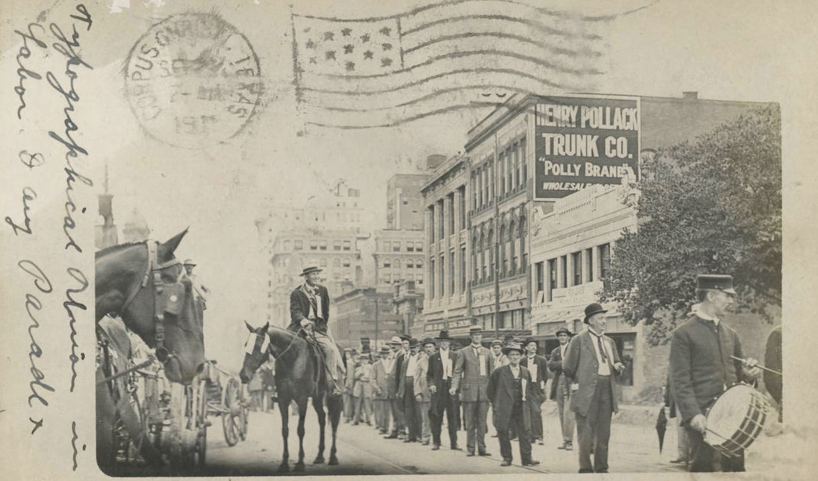
Union men on parade… (click for larger image)

by Paula Bosse

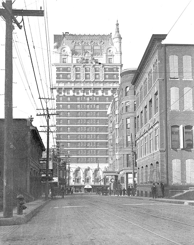
The photo above shows members of the Typographical Union marching in the Labor Day Parade held on Sept. 4, 1911. The photograph was taken looking west on Main Street toward St. Paul. (The Henry Pollack Trunk Co. was in the 1900 block, later occupied by the Titche’s building, now the Universities Center.)

The real photo postcard was sent three weeks later by John R. Minor, Jr. (a member of the union who worked as a linotype operator at The Dallas Morning News) to his mother, Mrs. Ada L. Minor, who was convalescing in Corpus Christi. (It’s possible the 27-year-old Minor was in this photo.)

Coverage of the day’s festivities can be read in the DMN article “Labor Day in Dallas Excels Past Record” (Sept. 5, 1911) here.

May your Labor Day not be spent walking behind a horse!

*

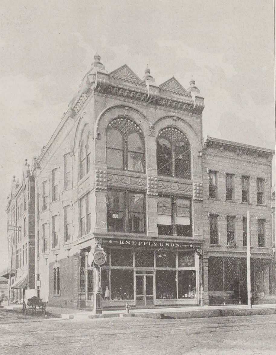
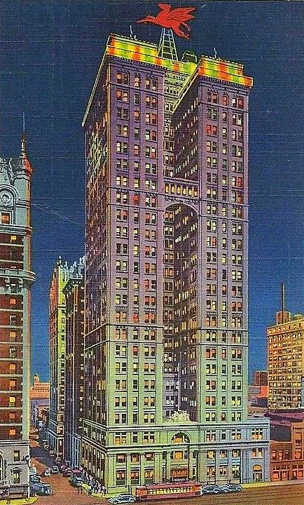
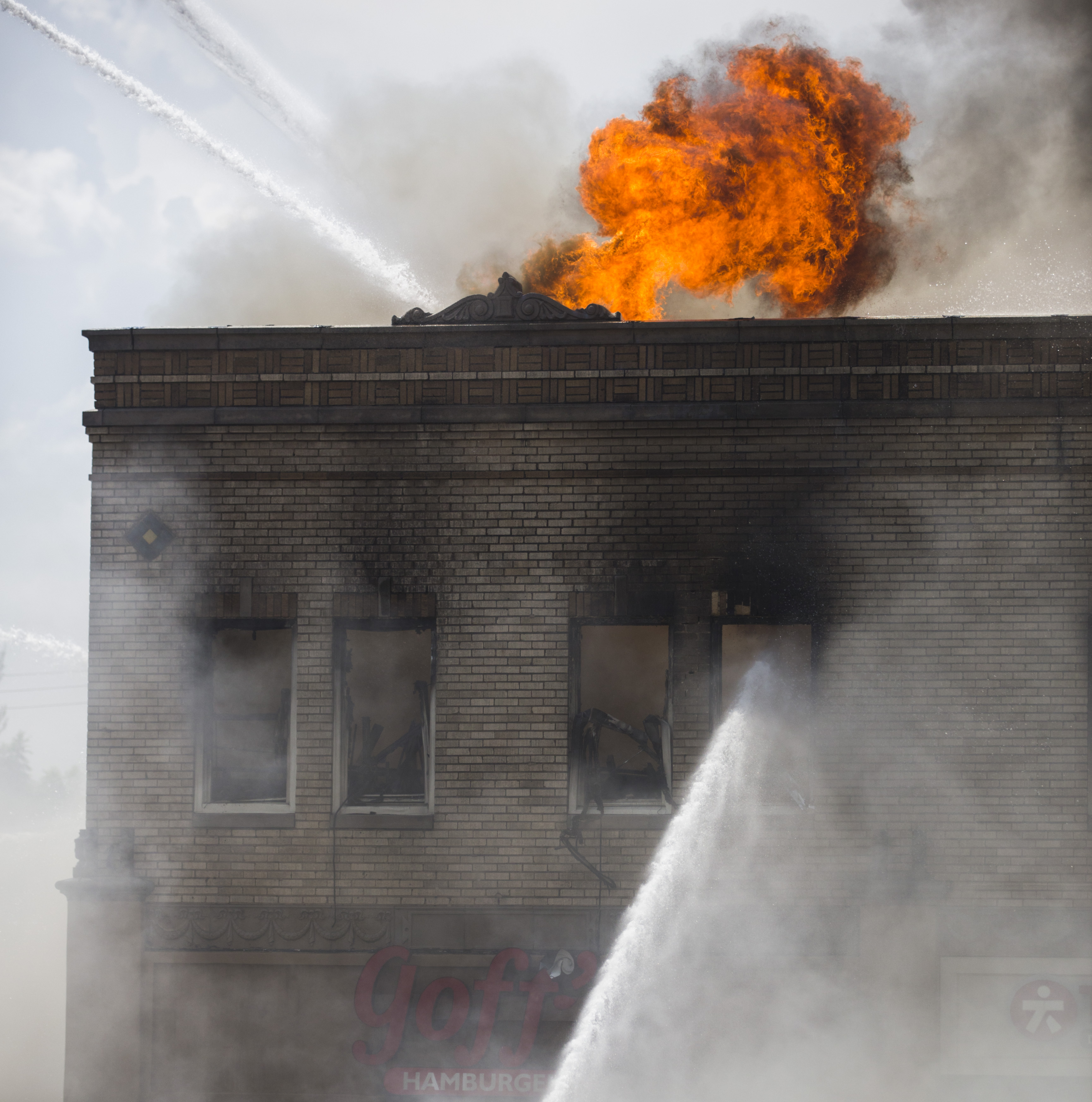
I feel I have to insert this bit of trivia here, if only because I spent so much time reading about the Minor family: in 1906, when John R. Minor, Jr. was 22 years old, the building in which he had a third-floor apartment was consumed by fire in the early hours of the morning. The three-story Knepfly Jewelry Building — built in 1888 on the southwest corner of Main and Poydras — was something of a landmark. The fire spread through the building so quickly that the only way to escape was to jump. Minor jumped and broke both legs and his pelvis. He was not expected to live, but he managed to pull through and spent several weeks in the hospital recovering. Two of the other top-floor residents died — one of whom had also jumped. Here’s the building. Minor had to jump past the telegraph wires on the Poydras (left) side of the building (the telegraph wires can be seen better in this photo from Dallas Rediscovered). He landed on his feet in the middle of the street. It’s amazing he didn’t break more bones. (Click for larger image.)

knepfly-bldg_church_dallas-through-a-camera_ca-1894_SMU

If he had marched in the 1911 Labor Day parade — which went west down Elm from about Pearl, then back east on Main from Lamar — he would have walked right past the building. On second thought, if he broke both legs and his pelvis, a mile-long march in a parade might have been a little taxing. (Maybe he’s the one on the horse!)

***

Sources & Notes

Postcard titled “Typographical Union in Labor Day Parade” is from the George W. Cook Dallas/Texas Image Collection, DeGolyer Library, Southern Methodist University; more info (and an image of the message side of the card) can be found here.

The photo of the Knepfly Building is by Clifton Church, from his book Dallas, Texas Through a Camera (1894), accessed from the DeGolyer Library, SMU Libraries, Southern Methodist University; more info is here.

Click pictures to see larger images.

*

Copyright © 2016 Paula Bosse. All Rights Reserved.


The Dallas Skyline: Spot the Landmarks

skyline_from-swMid-Century Big D… 

by Paula Bosse

The Dallas skyline is always changing, and it’s always been impressive. The late-’50s/early-’60s version above looks quaint by today’s standards, but it’s one of my favorite skyline periods. I’ve never been a huge fan of the Convention Center, but the rest of it? Pretty great.

In order to make way for the George Dahl-designed Dallas Memorial Auditorium/Dallas Convention Center (which opened in 1957), the old Columbian School/Royal Street School (built in 1893) was demolished. At the time of its razing, it had most recently served as the city’s school administration building and as a book warehouse. Here are a couple of photos of the school, long before the bulldozers arrived.

columbian-school_flanders-site
via James Edwards Flanders site

columbian-school_cook-collection
Cook Collection, SMU

Also interesting was that this land — which the city had been buying up for many years (some as a result of condemnation/eminent domain) also included four pioneer cemeteries. Read more about what happened to those cemeteries here.

dallas-convention-center_flickr-coltera

***

Sources & Notes

Top photo is from a site containing several photos relating to early KRLD radio and TV, with the occasional shot of Dallas streets and buildings, here.

Other sources, if known, are noted.

*

Copyright © 2016 Paula Bosse. All Rights Reserved.

The Adolphus, The Oriental, The Magnolia

adolphus_magnolia_oriental_TSHA-1977-annual-mtg_portal_sm
Akard looking north… (click me!!)

by Paula Bosse

This is just great. I’ve never seen this photo, which was taken sometime between 1922 and 1924. Dallas has never looked more … architectural. (Click that photo — it’s worth seeing it bigger.)

The view is looking north on Akard toward Commerce, from some building on or near Jackson Street. The Adolphus Hotel (built in 1912 and still standing) is straight ahead, the shorter Oriental Hotel (1893-1924) is in the middle, and the Pegasus-less Magnolia Petroleum Building (built in 1922 and still standing) towers above both of them.

I don’t think I’ve seen the Oriental from this angle. And I’ve never noticed all those windows in the Magnolia Building that look directly across into other windows. (That must be … strange.) And since I recently posted photos of this same block of S. Akard, I immediately recognized the short building with the odd-shaped cut-out/crest-like decoration in it opposite the Oriental.

Here’s the same view a few years earlier — about 1913, before the Magnolia was built:

adolphus_1913_dpl_via-d-mag-online

I love these photos. And how nice that two of these landmark buildings are still alive and kicking!

***

Sources & Notes

Top photo appeared in the program for the 1977 Texas State Historical Association Annual Meeting of 1977 (held, appropriately enough, in the Baker Hotel, which was built on the corner previously occupied by the Oriental); I found it on the Portal to Texas History site, here. (Dear printers of things like this: please never EVER use brown ink to print photographs. If anyone knows of a cleaner, sharper copy of this great photo, please let me know!)

Second photo is from the Texas/Dallas History Division, Dallas Public Library; I found it posted on the D Magazine site, accompanying the article “How Haunted Is the Adolphus Hotel?” here.

Photos larger when clicked.

*

Copyright © 2016 Paula Bosse. All Rights Reserved.


“Magnolia Building by Night”

magnolia-bldg-night

by Paula Bosse

Still standing. Still beautiful.

See a similar postcard, with a wider view — and a blobbier Pegasus — here.

*

Copyright © 2016 Paula Bosse. All Rights Reserved.

J. L. Long, Woodrow Wilson — 1958

woodrow_long_022758_squire-haskins_UTA_smBuccaneers, Wildcats: represent… (click for B-I-G image)

by Paula Bosse

Another fab aerial photo from Squire Haskins: a 1958 southwesterly shot of J. L. Long Jr. High School (on the left) and Woodrow Wilson High School.

…I am not unfamiliar with these East Dallas institutions. 

***

Sources & Notes

Photo taken above Lakewood by Squire Haskins on Feb. 27, 1958. From the Squire Haskins Photography, Inc. Collection, UTA Libraries, Special Collections — more info here. To see UTA’s super-gigantic image, click the photo!

*

Copyright © 2016 Paula Bosse. All Rights Reserved.

University Park’s “Couch Building” Goes Up In Flames (1929-2016)

goffs_fire_dmn-081216_ashley-landis-photo
Photo: Ashley Landis/DMN (click for huge image)

by Paula Bosse

Yesterday, fire erupted in the old University Park building at the northwest corner of Hillcrest and McFarlin. The building — which housed Goff’s Hamburgers and several other businesses — is, today, a pile of rubble. I’ve always loved this building — every time I’d drive past it I’d smile, happy that the only truly distinctive non-SMU building along that part of Hillcrest was still standing. And now it isn’t.

The building — which was built in 1929 across Hillcrest from McFarlin Auditorium — had a rocky start. SMU really, really didn’t want it to be built.

A. B. Couch (1895-1970) came to Dallas around 1914 from Waco to attend pharmacy school. In 1921, a few years after becoming a pharmacist, he opened his own drugstore, the University Pharmacy, at the southwest corner of Hillcrest and Roberts avenues (Roberts was renamed McFarlin Boulevard in 1928).

university-park-pharmacy_couch_1920-rotunda
Coming soon… (1920 SMU Rotunda yearbook)

Business must have been good, because in February of 1923, Couch bought the vacant property across the street. Three years later, he applied for a permit to build a business on the property, and that’s when the Robitussin hit the fan.

It’s a bit confusing, but, basically SMU, the original owner of the property (and all that surrounded it), put their land west of the campus (west of Hillcrest) on the market, but it could be sold only with specific restrictions — there were several of these restrictions, but the two cited most frequently were that land in this University Park Addition was to be developed solely for residential purposes, and that these homes were to be occupied by white people only. Somehow, in transferring property and re-deeding and re-re-deeding — and all sorts of other real estate transactions I don’t understand — the contract for the large lot purchased by Mr. Couch was drawn up with the restrictions omitted (“an oversight”). Couch was insistent on building businesses on the land he’d purchased, and SMU was adamant that he not be allowed to. Cue the lawsuit. (An overview of this case — in the appeals court — can be read here. It’s interesting, if confusing.)

The court case dragged on and on, through injunctions and appeals, and, finally, in December of 1928, the Supreme Court of Texas ruled in favor of Couch. (Click to see a larger image.)

couch_FWST_120628_supreme-court-of-tx-ruling
Fort Worth Star-Telegram, Dec. 6, 1928

In the spring of 1929, Couch released the drawing of the two-story F. J. Woerner-designed building he planned to build:

couch-bldg_woerner-rendering_1929

He also announced that he would build in this same block, a $125,000, 1,000-seat cinema: the Mustang Theater, which, though not yet built, had been leased for 10 years to R. J. Stinnette, who ran the Capitol Theater downtown. The building was designed by W. Scott Dunne, the architect of many of Dallas’ movie theaters (the Texas Theatre, the Arcadia, the Melba, the Dal-Sec, etc.).

mustang-theater_scott-dunne_rendering_1929

It doesn’t appear that the Mustang Theater was ever built, probably because the Varsity Theater in Snider Plaza (a stone’s throw away) had been announced that very same week (the Varsity opened in the fall of 1929).

So, forget the Mustang. Couch’s building — which was called, yes, “The Couch Building” — opened in 1930 or ’31. Its official address was 3402 McFarlin, but the address of the new location of the University Pharmacy was 6401 Hillcrest. There were a couple of stores next to the pharmacy, and offices upstairs (it seemed a popular location for doctors and real estate agents). Mr. Couch lived next door, at 3404 McFarlin (in a house which was, ironically, destroyed by fire in 1932).

That simple but lovely building stood on that corner for almost 90 years. Until yesterday. Sorry about that, A. B.

a-b-couch_pharmacist_1940sAndrew Bateman Couch, pharmacist

*

Below a photo taken on June 13, 1947, showing the “Highland Park/SMU” streetcar sitting at the end of the line, just south of Snider Plaza, with an 18-year-old Couch Building behind and to the left of the streetcar.


couch-bldg_061347_ebay

Below, the same view of Hillcrest looking south, from the 1965 SMU Rotunda yearbook. (Note that an unrelated University Pharmacy — this one owned by Harold Simmons — is seen at the southwest corner of Hillcrest and McFarlin. Couch sold his drugstore business in 1943, and a new pharmacy, which passed through several hands, opened across the street in Couch’s original 1921 location.)

drag3_smu-rotunda_19651965 SMU Rotunda

goffs_google_november-2015Google Street View, Nov. 2015

goffs_google_nov-2015_frontGoogle Street View, Nov. 2015

goffs_rubble_dmn-photo_081316_ting-shen-photographerDMN photo, Aug. 13, 2016 — Ting Shen, photographer

hillcrest-mcfarlin_map_goffs
Google Maps, Aug. 13, 2016 

***

Sources & Notes

Top and bottom photos are from the Dallas Morning News; see their coverage here, here, and here. That top photo is VERY large on The News’ website — look at all the detail of the brick and decoration.

Footage of the fire and its aftermath, from WFAA, can be watched here (scroll down to see all video footage).

Photo with the streetcar is from eBay; I saw it in the Retro Dallas, Texas Facebook group, posted by Dallas historian Teresa Musgrove Gibson.

Take a look at the 1921 Sanborn map, here. This building would be built at what is the northwest corner of Roberts (later McFarlin) and Hillcrest. University Park is pretty wide open in 1921.

*

Copyright © 2016 Paula Bosse. All Rights Reserved.

Neiman-Marcus Expands — 1927

n-m_construction_1927_pioneers-of-dallas-co-FB-page_coll-frances-james_2The first addition under construction, 1927…

by Paula Bosse

In 1927, construction began on Neiman-Marcus’ first expansion. The addition was adjacent to the famed department store, which had occupied its spot at Main and Ervay since its construction in 1914. (This was the company’s second location – their original store, which opened in 1907 at Elm and Murphy, was destroyed by fire in 1913.) The store had outgrown its old building, and expansion was deemed necessary. The new addition was designed by the Herbert M. Greene architectural firm, led by George L. Dahl. While the new building was going up, the old building was being renovated and updated. 

The photo above shows the construction of the addition, which extended the store’s footprint from Main all the way to Commerce. One of the interesting features of this construction was the look of the site itself.

One of the features of the Neiman-Marcus project is the ornamental barricade, containing window boxes and fashionable silhouettes, which has been put up around the new construction. (Dallas Morning News, May 8, 1927)

It’s the nicest-looking hard-hat area I’ve ever seen!

The new building (which was four floors, but was designed so that sixteen additional stories could be added if needed) opened in October, 1927. Less than a month after the formal opening of this new building, another addition was announced — it opened the following year. With that “third unit” opening in 1928, Neiman-Marcus had increased its size by 50% (there would be further expansions over the years), and its sales were the highest in the company’s history. Also, notable at this time was the fact that a full 40% of the store’s sales were to people who lived “in other cities of the Southwest.”

The formal opening on Oct. 3, 1927 attracted a crowd estimated at more than 25,000 people. Invited guests wore gowns and tuxedoes.

n-m_new-addition_dmn_100227
Expansion completed.

*

n-m_construction_dmn_100227_full-page-ad
Oct. 2, 1927 (full-page ad — click to see larger image)

n-m_addition_dmn_100227_architects
Oct., 1927

***

Sources & Notes

Top photo was posted in the Facebook group Pioneers of Dallas County; it is from the collection of Dallas historian Frances James.

A special section of The Dallas Morning News which coincided with the opening of the expanded store appeared in the October 2, 1927 edition of the paper; in it are several photos and articles.

Read more about the history of the Neiman Marcus building on Wikipedia, here.

*

Copyright © 2016 Paula Bosse. All Rights Reserved

Thank You, Preservation Dallas!

wilson-house_FB-page_cover-photoThe historic Wilson House, home of Preservation Dallas

by Paula Bosse

I was invited by the nice people of Preservation Dallas to be part of their Summer Sizzlers Series and to present my first-ever lecture/talk: on how I write the blog and what resources I use. Somehow I managed to stand in front of a packed roomful of people (one of my greatest fears) and talk for 90 minutes (!) — and, surprisingly, I think my presentation was mostly coherent. I have to admit, a lot of it is a hazy blur, but I was happy to find that it was an enjoyable experience. I had a great time, and it was nice to talk to so many people who are as interested in Dallas history as I am.

Thank you Irene Allender, David Preziosi, and Donovan Westover for inviting me and for hosting such a nice event!

preservation-dallas_logo_2016

preservation-dallas_summer-sizzlers

***

Sources & Notes

Photo at top shows the beautiful Wilson House, built in 1899 at the corner of Swiss and Oak and current home of Preservation Dallas. Read more about the house here; read about the Wilson Block Historic District here. Take a virtual Google Street View tour of the wonderful two blocks’ worth of historic houses here. (Photo from the Preservation Dallas Facebook page.)

After the lecture, I had several people ask about the PowerPoint 2016 presentation I’d made. This was the first time I’d ever used PowerPoint, and it worked really well for showing many (MANY!) photographs to the audience. For those of you who came up and asked me about it, the very, very well done YouTube tutorial I used to teach myself PowerPoint is here. It’s in 10 segments — about 3 hours in all — you might not need everything in it, but I found it very helpful.

*

Copyright © 2016 Paula Bosse. All Rights Reserved.

Beautiful South Ervay Street — ca. 1910

ervay_coltera_flickrStreet life in South Dallas

by Paula Bosse

Today, a few hand-colored postcards from around 1910 showing the lovely houses that used to line Ervay Street in South Dallas. Hard as it is to believe today, the stretch of South Ervay from just outside the central business district down to its end at Forest Avenue (now Martin Luther King, Jr. Blvd.), was once a very nice area where many of the city’s most fashionable and well-to-do Jewish families (and, later, African American families) lived. The intervening century has not been kind to South Dallas. I’m not sure of the location in the postcard above, but it certainly looks like a very pleasant neighborhood — one that no longer exists in this mostly blighted area.

*

Below, S. Ervay looking south. The rounded top of Temple Emanu-El can be seen at the left. The light-colored building in the next block was the Columbian Club. The hotel most recently known as the Ambassador (which burned down three years after I originally wrote this post) is set back on a curve of the street and is hidden by the Columbian Club. The red building is the Hughes candy plant (still standing). A Google Street View of this area today can be seen here.

ervay-street_ebay

*

Below, we see a view still looking south, but now much farther down Ervay, almost to Forest Avenue (now MLK). The church on the left is the James Flanders-designed Ervay Street Methodist Episcopal Church (South), built in 1908 at the corner of corner of Ervay and South Boulevard — it’s interesting that a Methodist church was located in the center of Dallas’ largest Jewish residential neighborhood. (More on the church from a Dallas Morning News article from July 1, 1908, here. See this area on a 1922 Sanborn map here.)

ervay-residence_coltera

Not seen in the view above is one house worth mentioning. The house — just out of frame at the left, with the steps leading up to it, was the home of Simon Linz, of Linz Jewelers fame. Here is what the Linz house looked like in 1908:

linz-house_dmn_010108Dallas Morning News, Jan. 1, 1908

Remarkably, this house is still standing. It is currently a funeral home at 2830 S. Ervay. The present-day image below, showing the pretty house and the neatly landscaped yard, is a little deceptive; see what the Google Street View looks like just south — where the Flanders church once stood — here. (If you’re up to it, reverse the Google view and move back toward town.)

linz-house_2830-828-s-ervay_google
Google Street View

Hold on, little house!

This was once such a beautiful part of Dallas….

ervay_postcard_clogenson_postmark-1908

**

Below, a detail of a 1919 map showing S. Ervay down to Forest. The purple star shows the location of Temple Emanu-El and the Columbian Club. The green star shows the location of the Linz house and the Ervay St. Methodist Episcopal church. (Click for larger image.)

e-ervay_map_1918_portal
1919 map via Portal to Texas History

 ***

Sources & Notes

First and third postcards are from Flickr: here and here. Others found on eBay.

*

Copyright © 2016 Paula Bosse. All Rights Reserved.

Dallas Skyline — ca. 1974

skyline_aerial_1974_getty-images_watermarkSo many landmarks! (click for larger image)

by Paula Bosse

I try to avoid using photos with watermarks, but this is a great view of the Dallas skyline, taken by famed photographer Charles Rotkin. Below, another of his photos.

aerial_skyline_corbis_1974

***

Photos by Charles Rotkin. Top photo from Corbis/VCG via Getty Images. Bottom photo ©Charles E. Rotkin/CORBIS (I can no longer find this image on the new Getty site). CORBIS/Getty says that both of these photos were taken on Jan. 1, 1974, but I’ve found that their date info is sometimes inaccurate.

2004 obituary of Charles Rotkin is here.

Click photos for larger images.

*

Copyright © 2016 Paula Bosse. All Rights Reserved.