4500 block and/or 5800 block of Lovers and/or W. Lovers Lane
by Paula Bosse
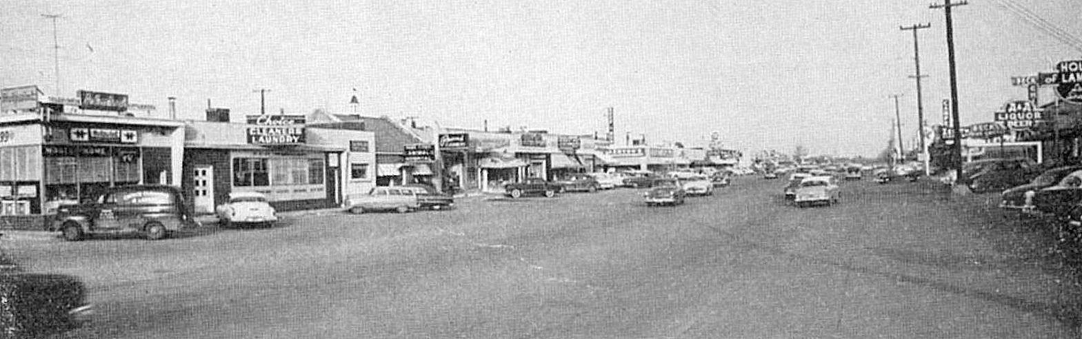
The photo above is a detail from an ad for some of the businesses along the Miracle Mile (Lovers Lane, between about Douglas and what is now the toll road). The caption is: “The fabulous Miracle Mile looking west toward Douglas Ave.” (Surely this is a view to the east?) The same view today can be seen on Google Street View here. The ad appeared in a March 1954 magazine. At that time, the photographer would have been standing in front of Roscoe White’s Easy Way restaurant (5806 W. Lovers Lane). Here’s the ad (click to see a larger image):
*
Shop on the MIRACLE MILE! On Lovers Lane from Douglas Ave. to Cotton Belt Railroad tracks PLENTY OF PARKING!!! The following merchants invite you to shop with them:
Beef ‘N Bun No. 1, 4500 Lovers Lane Bernard’s Carpets, 4445 Lovers Lane The Book Shelf, 4354 Lovers Lane Choice Cleaners, 4530 Lovers Lane Ernstrom’s Record Shop, 4356 Lovers Lane Florentine Shop, 4437 Lovers Lane Guildcraft Furniture Studio, 4433 Lovers Lane Hodges Photographer, 4514 Lovers Lane House of Carpets, 4408 Lovers Lane House of Lamps, 5812 W. Lovers Lane Jean & Morry’s, 4437 Lovers Lane Margie’s Dress Shop, 4508 Lovers Lane Miracle Mile Pharmacy, 4400 Lovers Lane Miracle Mile Stationers, 4506 Lovers Lane New York Bakery & Delicatessen, 4412 Lovers Lane Park Cities Hardware & Paint Co., 4338 Lovers Lane Party Bazaar & Gift Shop, 4439 Lovers Lane Peek’s Auto and Appliance Store, 4365 Lovers Lane Rae Ann Shop, 4417 Lovers Lane Seidel’s Boys’ and Girls’ Apparel, 4504 Lovers Lane Squire — The Man’s Shop, 4441 Lovers Lane Stone’s Buster Brown Shoe Store, 4449 Lovers Lane
Every day is shopping day on the Miracle Mile Open Thursday night — open Thursday night — open Thursday night
**
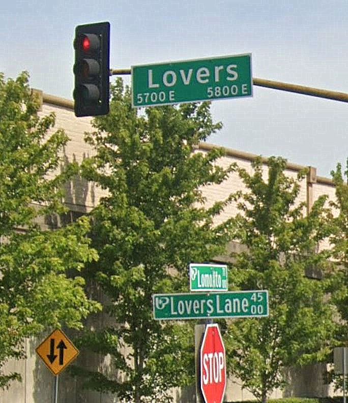
So. Lovers Lane. What’s the deal, Lovers? Your numbering system is insane. For instance, in the photo above, Choice Cleaners (second business on the left) is at 4530 Lovers Lane. It is directly opposite House of Lamps, which is, inexplicably, at 5812 West Lovers Lane. Not only are the block numbers nowhere near the same, the numbers of addresses on both sides of the street are even. There are businesses on both sides of the street, but that block has no odd-numbered addresses. …But only until you pass Beck’s Fried Chicken at 5820 West Lovers (you can see it on the photo at the far right, next door to AAA Liquor at 5814 W. Lovers Lane). Once you cross Lomo Alto, heading east, the numbering suddenly starts at 4455 Lovers Lane (Brady’s Texaco Service Station). West Lovers Lane is no more. You’ve just lost West Lovers Lane and 14 blocks. You might be in the Twilight Zone. I’m pretty sure the whole University Park-thing is the reason, but, oh my god. My brain melts down every time I try to make sense of this! Imagine not knowing your way around this part of town and seeing this confusing collection of signs after getting off the toll road:
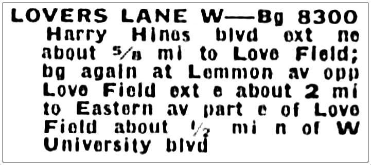
For future reference, here is some even more confusing guidance, from the 1953 city directory. “WEST LOVERS LANE”:
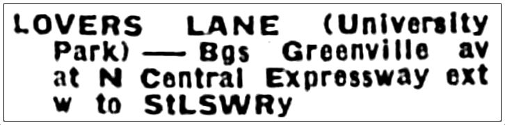
PLAIN OL’ “LOVERS LANE”:
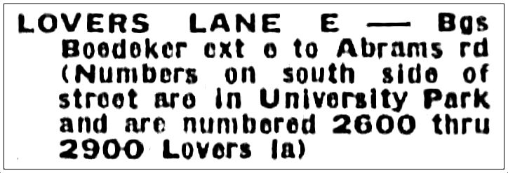
“EAST LOVERS LANE”:
Good luck keeping track of that. There will be a quiz. You might need a slide rule, a compass, and a bottle of aspirin.
***
Sources & Notes
Ad is from the March 1954 issue of Town North magazine, a publication by and for super-boosters of the Park-Cities-and-Preston-Hollow area, which they were trying to get people to call “Town North.” It makes about as much sense as Lovers Lane’s numbering system, but it’s a cool magazine that lasted a few years and can be found in the Periodicals Collection of the Dallas History and Archives at the Dallas Public Library.
More on The Miracle Mile (with a handy map, if you’ve ever wondered what its “official” boundaries are) can be found in this Flashback Dallas post: “Stacy’s Lounge on The Miracle Mile — 1950.”
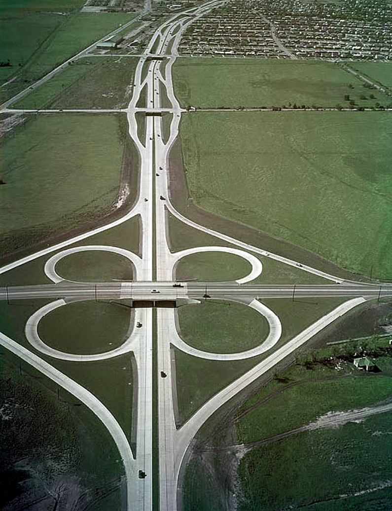
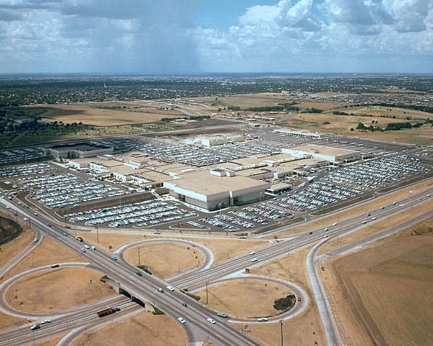
I have such a weird fondness for the old Central Expressway/Northwest Highway cloverleaf interchange, at NorthPark. In fact, I kind of forget it’s not there anymore. I have fairly scary memories of my mother driving like a bat out of hell on it. I’m pretty sure the car was tipped at an angle on two tires as we rounded those curves. And I remember being behind the wheel myself when I was a new driver, white-knuckling it until I hit the straight-away. Strange that I have such fond memories of it, because a lot of those memories were kind of terrifying! I guess it has to be the design. It was cool. COOL! The photo above is just great. The view is to the south from Northwest Highway, across open Caruth farmland. Mid-’50s. Pre-NorthPark. Pre-people. Pre-traffic.
Below, after NorthPark’s arrival (photo from Oct. 1967):
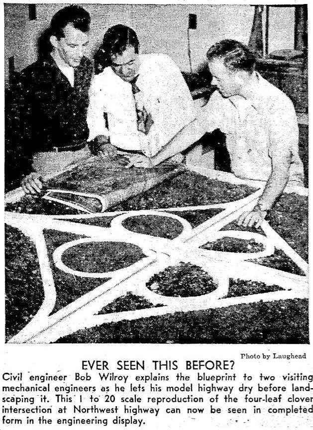
Here’s an interesting photo I stumbled across in an issue of SMU’s Daily Campus newspaper from 1951 — a personal-size cloverleaf:
SMU Daily Campus, May 5, 1951
I really miss the Northwest Highway cloverleaf. I think about it almost every time I drive past NorthPark on Central. Shoulda kept it, Dallas.
***
Sources & Notes
The top two photos are from the book Dallas-Fort Worth Freeways by Oscar Slotboom (top photo from TxDOT, second photo from UTA Libraries, Special Collections).
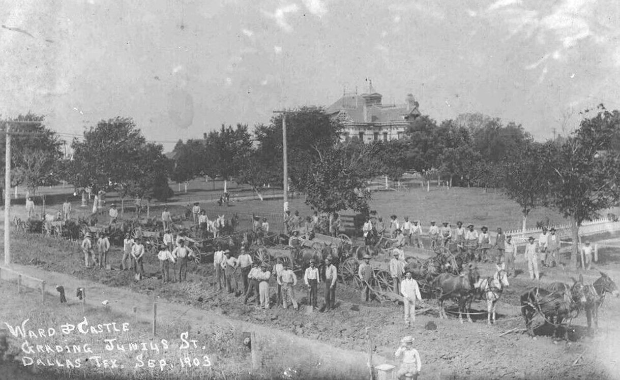
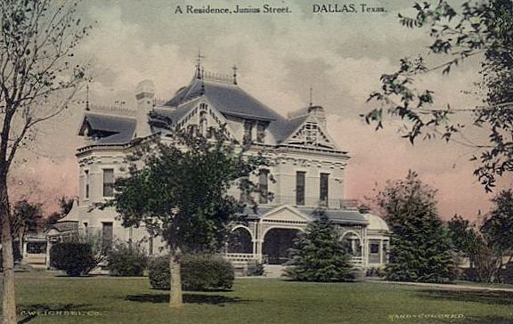
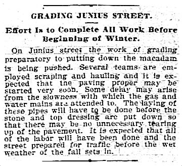
Here’s an interesting photograph I stumbled across on eBay. It shows Junius Street in East Dallas, between Peak and Carroll, taken in September 1903, as workers were grading the street as part of the paving process. The mammoth house seen on what looks like a hill, belonged to John B. Wilson (namesake of the Wilson Building downtown), who had purchased the grand home from Thomas Field in the 1890s. (This beautiful house — built in 1884 — was demolished in 1922 in order to free up land for apartments, etc. Read more about this in the 2014 post “Junius Heights … Adjacent!”) Here’s Wilson’s home, up close:
The house was built in 1884 at the northeast corner of Junius and Peak — it sat on a lot of land. By 1903, after other houses had been built around it, it occupied almost half a block, bounded by Junius, Peak, and Gaston. (See this area on Sanborn maps from 1905 and 1922 — it’s pretty easy to spot the house!)
But back to the 1903 photo. It shows road work on Junius, which, up until that point, had been a dirt/gravel road.
In March 1903, residents of Junius Street asked the City Council to pave their street between Haskell and Fitzhugh. I’m sure their main goal was to live on a nice, paved street instead of one that became a nasty, muddy nightmare when it rained — but, perhaps to make it seem more egalitarian, they zhuzhed up their request by saying that “Junius street is the principal outlet to Garland, Reinhardt and the country surrounding those towns.” They noted that the county had kept the continuation of the road outside the city in good condition and that this stretch of paved road would provide “a connecting link between the city and the country.” (I don’t know how important this “connecting link” was, but the stretch of road they wanted paved was only half a mile long. It seems pretty ballsy to request that the city pave this very short bit of road, which would have resumed being unpaved east of Fitzhugh…. and on to Garland and Reinhardt. I think there’s no question that Moneyed Resident Wilson — who, let’s not forget, was building the very large Wilson Building downtown at this time — had a lot of sway amongst the city leaders.)
The group approached the city with a proposition in which they, the homeowners, would pay for half the cost of the construction, with each of them paying 50¢ for every foot of their property which fronted the street. (Surprisingly, only two property owners had an issue with this — one of them was Dr. Buckner of the Buckner Orphans’ Home (before it relocated to the ‘burbs, it was at 4120 Junius), who said the home did not have the funds for this, but he personally ponied up a $50 contribution, the equivalent of about $1,700 in today’s money.) The city seemed happy with this and agreed to match the $2,500 collected by the group. (Mr. Wilson’s share must have been substantial.) I don’t know what the tax situation was back then, but it’s odd that people once had to do this. I would guess that very few streets were paved beyond the Central Business District in this era — who could afford that? I guess that’s why so many real estate ads from the past stressed that the streets of their new developments were all paved.
The Junius improvements included the laying/installing of cement sidewalks, a macadamized roadway, and bois-d’arc-block gutters. The grading work (shown in the photo at the top) began in August 1903.
Dallas Morning News, Aug. 25, 1903
There were, of course, delays, caused by a lack of materials, weather, the necessity of having to wait while gas and water mains were laid, and having to either rebuild a bridge over the road or build a culvert under the road (the city went with the cheaper culvert). Work was still going on in December, but I gather the job was completed early in 1904.
*
Leadership of the neighborhood group was comprised of two people from each block (one from each side of the street). The leaders for what is now the 4700 block of Junius were John C. Ward and C. J. Castle (their names are on the photo showing this work in progress). The notation below is written on the back of the photo: “J. B. Wilson home in background (built Wilson Building downtown). J. C. Ward my grandfather. Mary Musick.”
J. C. Ward (1851-1937) came to Dallas in 1874, traveling in a covered wagon, witnessing buffalo stampedes and white-knuckling it through Indian territories. He was pals with an elderly John Neely Bryan. He worked as a contractor and must have done well, as he owned houses on several lots in the 4700 block of Junius, most of which were occupied by family members (including his daughter, Ella Ward Arnold, and his granddaughter, Mary Arnold Musick) — his own home was in the 6100 block of Junius, which appears to be the current location of the Lakewood Library. At one point he owned 72 acres of farmland on the eastern edge of Dallas, but it was condemned by the city in order to build White Rock Lake. He didn’t seem to hold too much of a grudge, because his major pastime was fishing, and he frequently walked the 2 miles to the lake from his home to fish, well into his 80s.
He seems to have had a real affinity for Junius Street. I love the fact that he and his across-the-street neighbor, C. J. Castle, memorialized the paving of their street with a specially commissioned photograph and managed to get all the workers to pose for it. The paving of Junius must have been a particularly gratifying achievement.
***
Sources & Notes
Top photo is from eBay — it is currently for sale, here.
If you enjoy this sort of thing, check me out on Patreon, where, for a subscription costing mere pennies a day, you can receive daily, bite-size Dallas-history posts directly in your inbox.
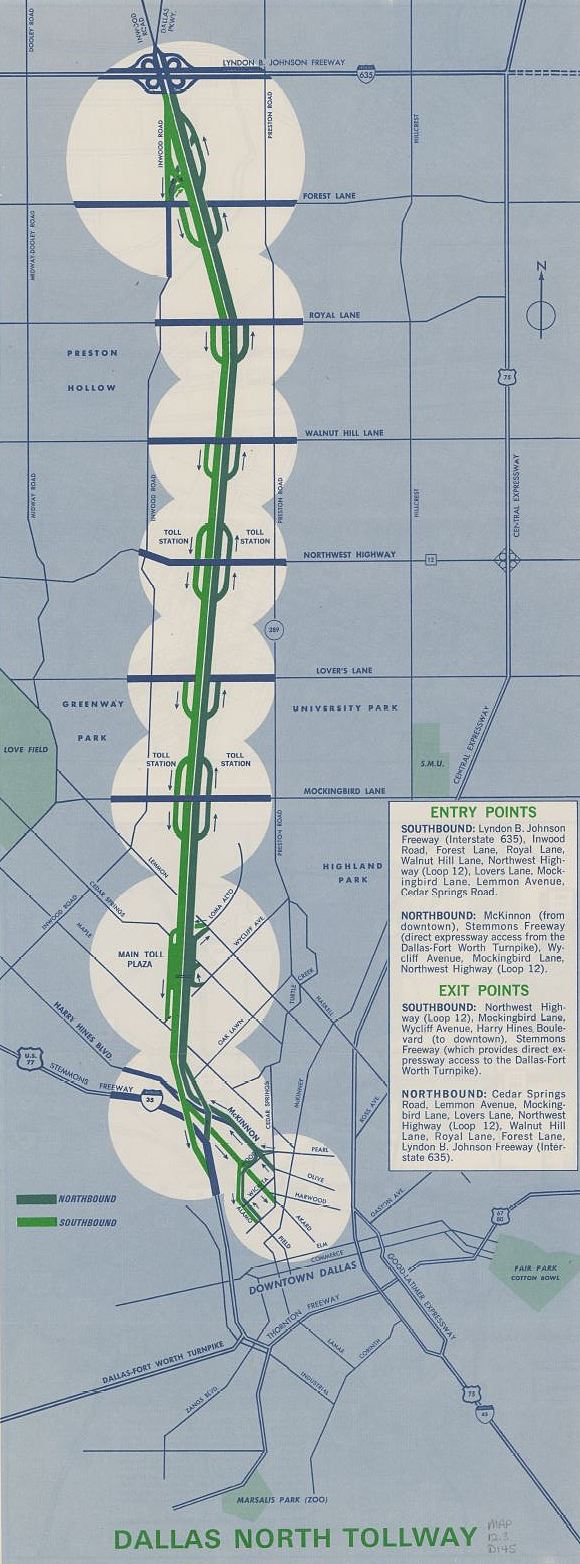
The Dallas North Tollway opened in stages, as stretches were completed. The first bit of its 9.8 miles opened in February 1968, and it was fully open by June 1968. From downtown to LBJ. Am I crazy, or does that seem incredibly fast?
On its opening day, an ecstatic Texas Turnpike Authority official told reporters, “People love it to death.” Which is something you don’t hear said everyday about a toll road.
When one speaks of the tollway, one often muses to oneself, “Shouldn’t this thing be paid off by now?”
Here’s what the Texas Turnpike Authority assured taxpayers back then in that Summer of Love:
Like Dallas-Fort Worth Turnpike, the Tollway was financed by the Texas Turnpike Authority through the sale of revenue bonds. And like the Turnpike, the Tollway will become a toll-free portion of the Texas Highway System when its bonds are retired.
Unbelievably, the DFW Turnpike DID become a “free” highway, but I think we all know that will never happen again. But, just for an amusing tidbit to toss around at your next smart cocktail party, here’s when that was supposed to happen (from the final paragraph of a very comprehensive Dallas Morning News overview of the history of the tollway):
If the traffic keeps going up and coincides with projections, the tollway may become part yours — as a Texas citizen — on Jan. 1, 2005. That’s when the last bond payment is due. (DMN, June 2, 1968)
I guess the important word there was “may.”
I don’t really have any nostalgia connected with the tollway, but I do kind of miss hurling a fistful of change at that basket.
***
Sources & Notes
Dallas North Tollway brochure (1972) is from the Southwest Collection Maps, Special Collections Library, Texas Tech University — it can be downloaded here.
The very informative article referenced above is “Dallas North Tollway: A Long Road is Ending” by Jimmie Payne (Dallas Morning News, June 2, 1968).
The Gateway to Dallas, or the the Gateway to Oak Cliff?
by Paula Bosse
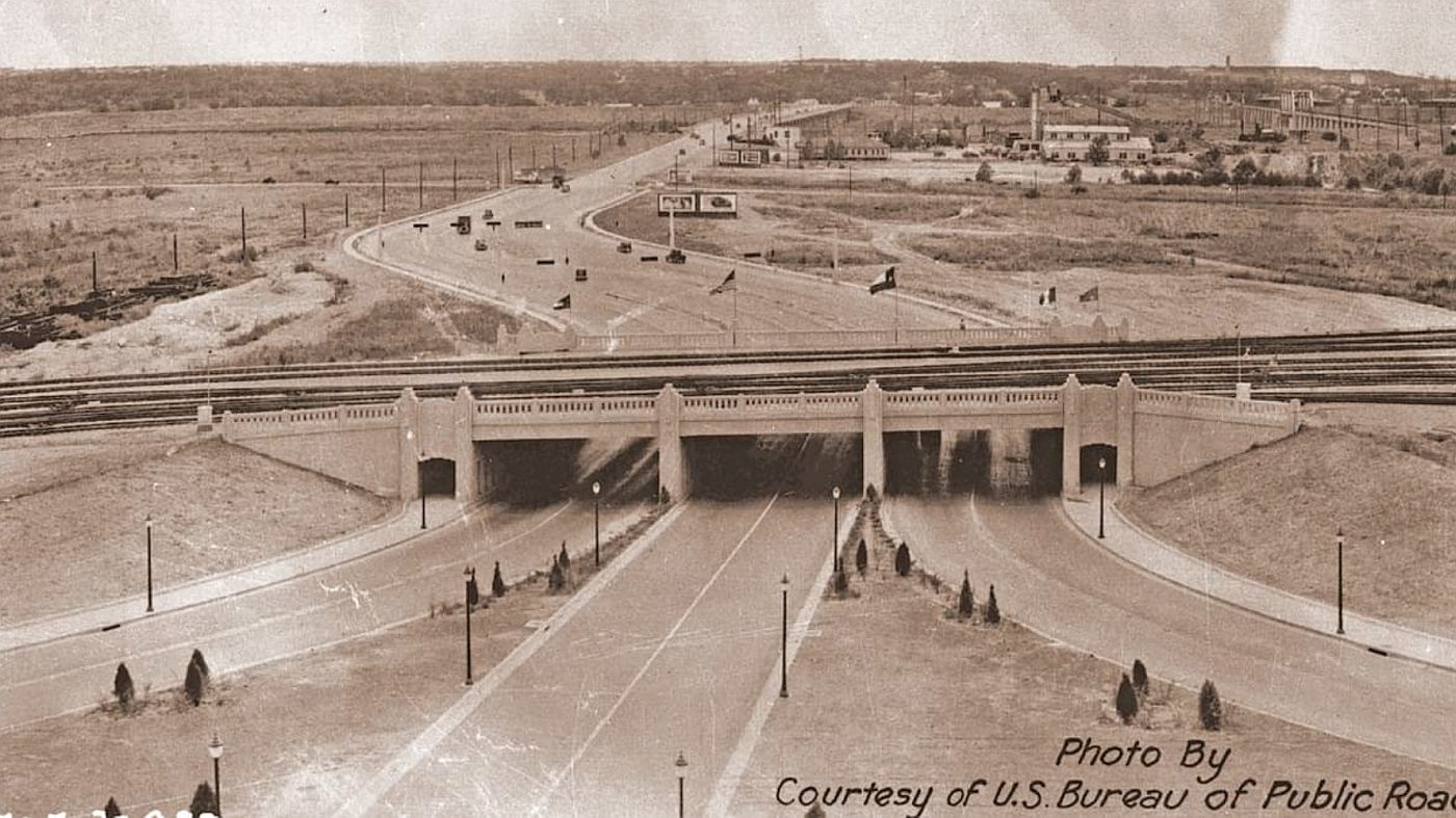
Above, a fantastic photo showing the new Triple Underpass, about 1936, with the view toward Oak Cliff. (Compare this with a similar view, from the 1950s, here.)
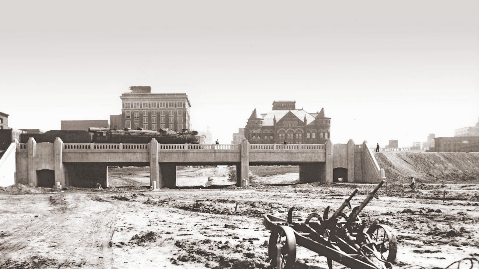
Below, a little earlier, with the view to the east, back toward town.
The triple underpass was built by the Austin Bridge & Road Company between 1934 and 1936, finishing up just in time to welcome the onslaught of visitors to the Texas Centennial Exposition. I encourage you to visit the company’s public Facebook post here, which includes these and other great photos of this Dallas landmark (including a “then and now” comparison and a history of their involvement in the project). Below is an excerpt from that post:
Once called the “Gateway to Dallas,” the triple underpass near Dealey Plaza was built by Austin Bridge Company and Austin Road Company starting in 1934. The underpass, a joint project with the Texas Highway Department and City of Dallas, created access to the western edge of downtown Dallas under the Union Terminal tracks. Contending with up to 80 trains a day complicated the job, requiring close cooperation with the railway companies. The triple underpass was hailed as a modern marvel, built of concrete with square balusters in a handsome art-deco style. It was unveiled with great excitement in 1936, during Texas Centennial celebrations.
***
Sources & Notes
Top image is a U.S. Bureau of Public Roads photo showing the new underpass, looking to the west.
Both photos and the excerpt are from a post on the Austin Bridge & Road Facebook page, which you can find here.
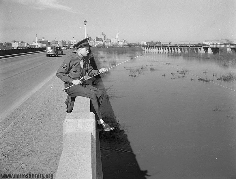
A soldier in uniform, sitting on the concrete railing of a viaduct, casting into the Trinity.
When I posted this in a Dallas history group several years ago and asked which viaduct is shown, there was no consensus — Houston Street was mentioned most often, but just about all of them got several votes!
***
Sources & Notes
I can’t remember where I came across this photo (which is dated Feb. 28, 1948), but it is from the collection of the Dallas Public Library.
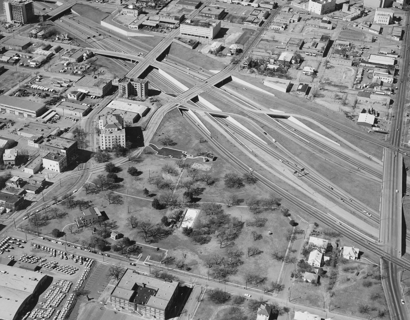
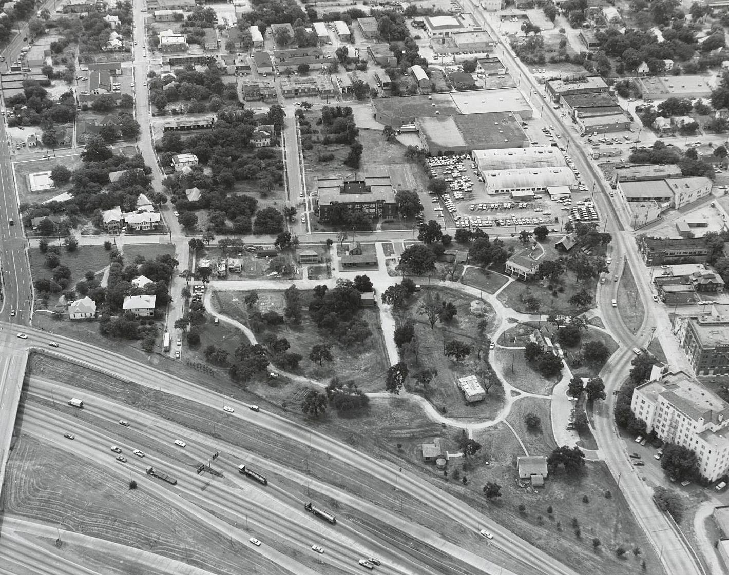
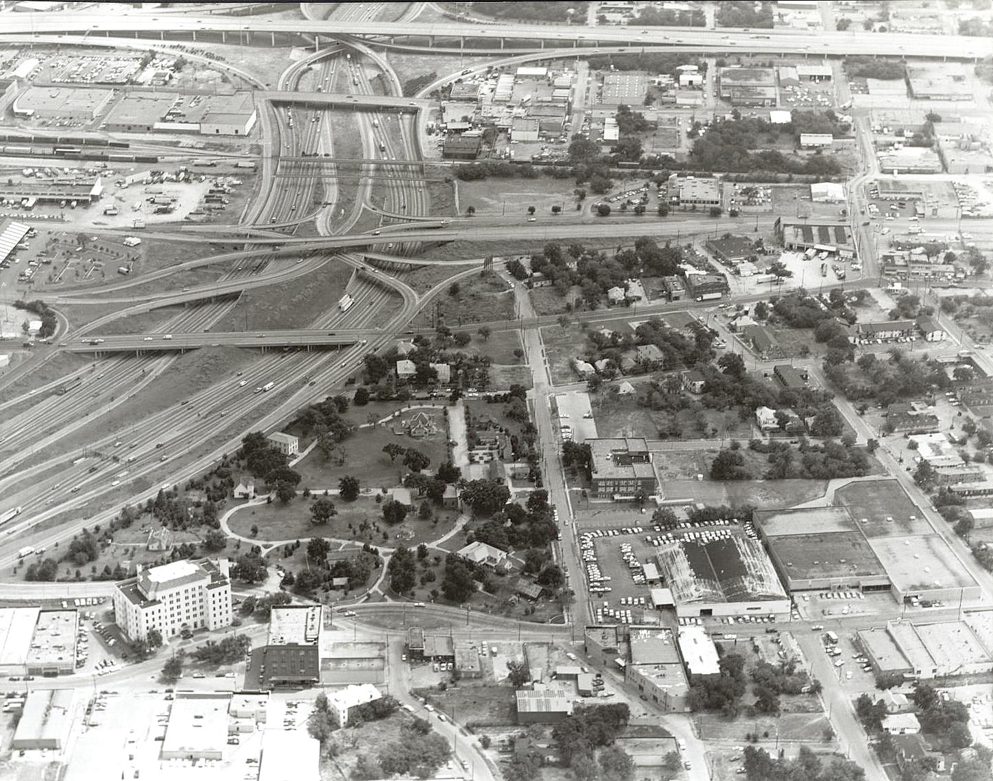
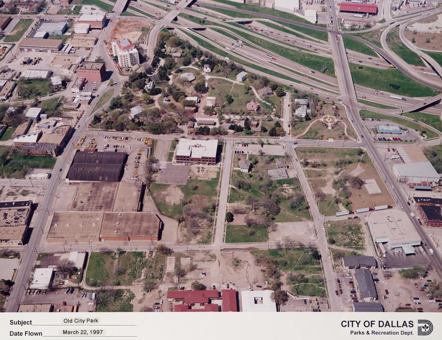
These eight aerial photos of City Park/Old City Park in The Cedars, just south of downtown, show the encroachment of an ever-increasing acreage of asphalt onto what was once the city’s most beautiful park. (All photos are from the Dallas Municipal Archives, and all are larger when clicked.) The one thing present in all photos is the late Ambassador Hotel (RIP).
Above, in 1948, before the cement mixers arrived (photo by Barnes Aerial Surveys).
Below, 1954.
Squire Haskins, Dallas Municipal Archives, 1954
1966:
Squire Haskins, Dallas Municipal Archives, 1966
1969:
Squire Haskins, Dallas Municipal Archives, 1969
1972:
Squire Haskins, Dallas Municipal Archives, 1972
1975:
Squire Haskins, Dallas Municipal Archives, 1975
Circa 1982:
Dallas Municipal Archives, ca. 1982
1997:
Reginald D. Loftin, Dallas Municipal Archives, 1997
Today-ish (or at least before the Ambassador burned down in May, 2019):
Google Maps
***
Sources & Notes
All photos are from the Dallas Municipal Archives Collection, via the Portal to Texas History; they can all be found here.
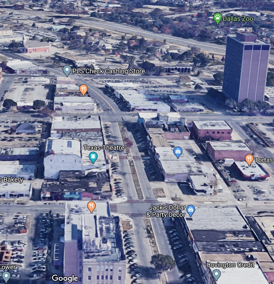
I love night-time views of a lit-up city, and this circa-1949 bird’s-eye view of West Jefferson Boulevard in Oak Cliff, looking east, is pretty cool. If this photo had a soundtrack, it would be moody and atmospheric saxophone music.
Hunt’s department store was at 303 W. Jefferson, and the Oak Cliff Bank & Trust Co. was at 250 W. Jefferson — S. Madison is the intersecting street in the center of the photo. At the upper left you can see the bright lights and triangular marquee of the Texas Theatre. Below is a view of the same street today, still recognizable.
Google Maps
***
Sources & Notes
Top photo is from the Flickr photostream of OldOakCliffLodge, here.
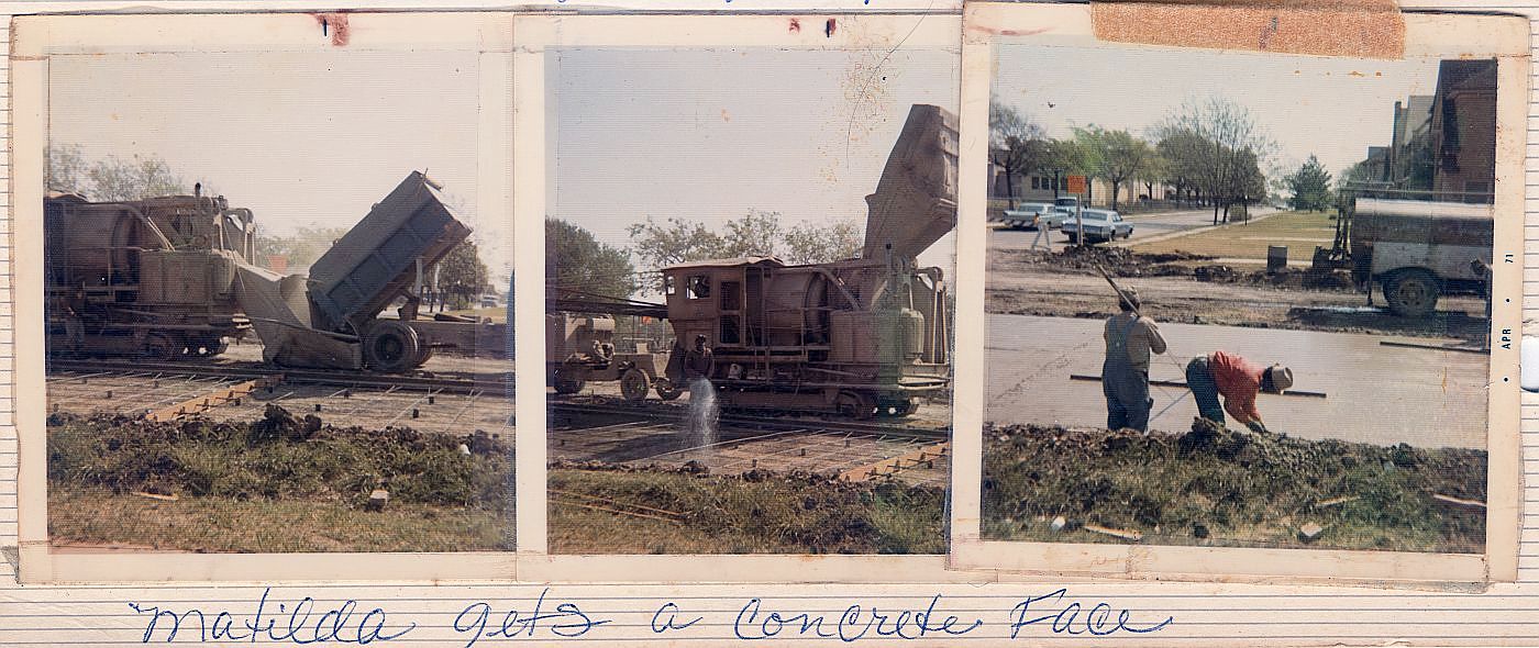
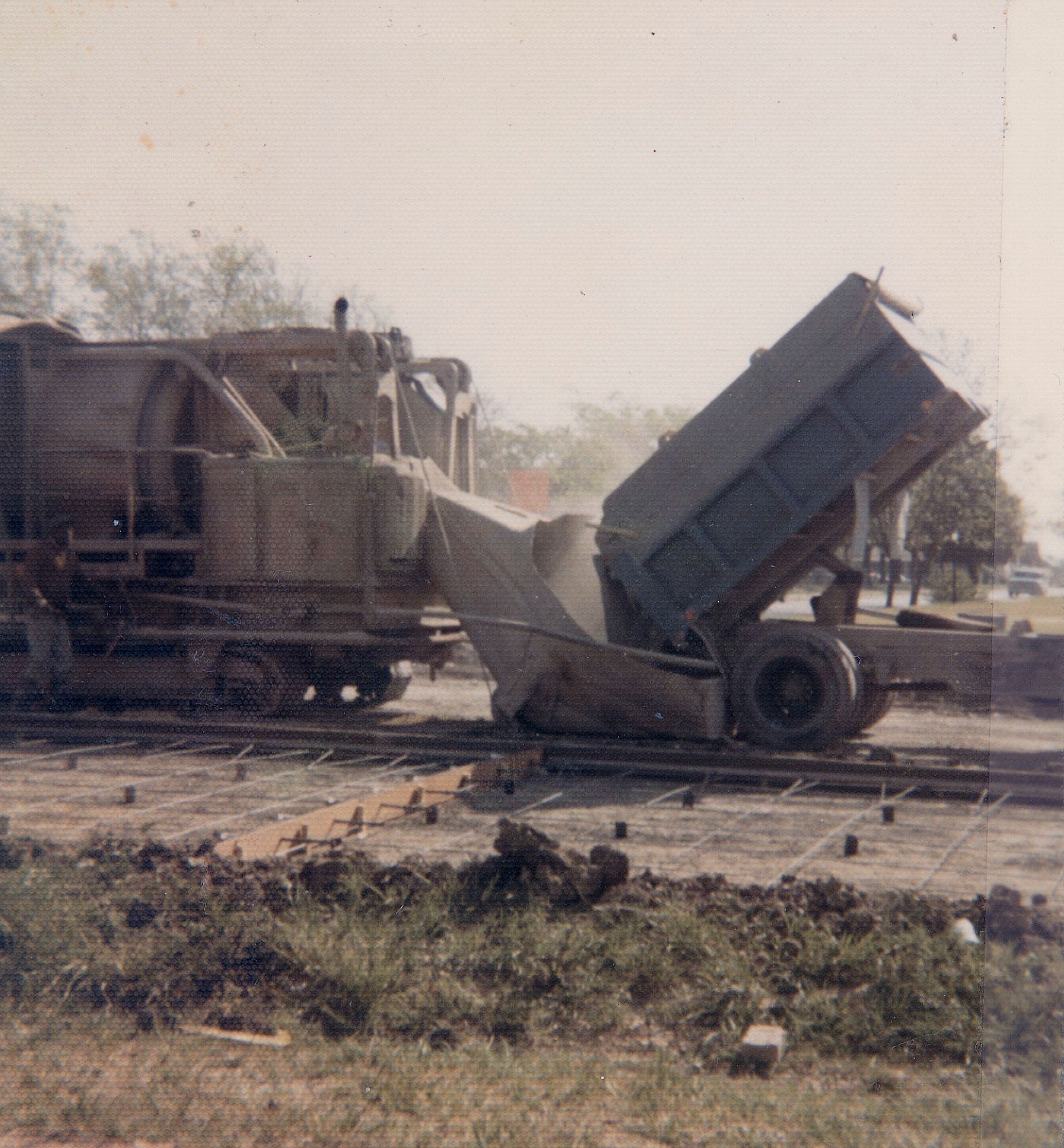
“Matilda gets a concrete face”… (click for larger image)
by Paula Bosse
A couple of days ago I wrote about the history of Matilda Street in regard to its role as a railway for the Sherman-Denison interurban and the Belmont streetcar line. I noted that I had childhood memories from the 1970s of Matilda being a dirt street — which seems hard to believe these days since it carries a fair amount of traffic and is generally a quicker drive than Greenville Avenue, one block west.
In response, one of the many Milazzo siblings (whom I remember not as individuals but as one large flock of children who regularly accompanied their parents to visit my father’s bookstore in the 1970s and ’80s) sent me some photos from a family album showing, yes, Matilda Street being paved! They lived in the 5700 block of Goodwin, and the photos were taken in 1971, from their yard, looking east across Matilda.
The streetcar tracks were abandoned in 1955 but were not removed — it took a full sixteen years for them to be paved over! Before that? Dirt street. If you look closely at the Google Street View capture from Oct. 2017, you can see the old rails peeking through.
Below are three photos from the Milazzo’s family album showing the Matilda “street improvements.” The construction vehicle seen in the first two photos is pretty weird-looking — like a cross between a locomotive and a tank. In fact, at first I thought the thing was actually running on the rails it was working to pave over, until I saw that what I had thought were train wheels look more like tank treads. Whatever it is, it doesn’t look like something you’d expect to see on a residential street in the 1970s. In the third photo, you can see part of Robert E. Lee Elementary School at the left. (All photos are larger when clicked.)
Thank you, Milazzo family!
***
Sources & Notes
Photos from the collection of the Milazzo family, used with permission. The third photo shows a date-stamp of April, 1971.
The related Flashback Dallas post “Ghost Rails of the Belmont Streetcar Line” is here.
Matilda & Richmond, April, 2018… (photo: Dan Parr)
by Paula Bosse
I grew up on Ellsworth, between Greenville Avenue and Matilda — just south of Mockingbird, just north of the M Streets. When I was a child, Matilda was only partially paved — in my neighborhood, maybe only from Mockingbird down to Kenwood? Otherwise, it was a dirt street (!) — and this was in the ’70s! Right around Kenwood was a weird mound which might not have looked like much to an adult, but to a child it was pretty strange. I can’t remember if the rails were visible — I’m pretty sure they were.
That line was the Belmont Line, which ended (began?) at Mockingbird (I think there was a later extension of sorts, but I think Mockingbird was the end of the line for streetcar passengers). As a kid, I knew that Matilda had been a long-gone streetcar line, but never having seen a streetcar outside of a movie, I couldn’t really imagine what it must have been like to have streetcars (and an interurban! — more on that below) moving up and down a street which was less than a block from my house.
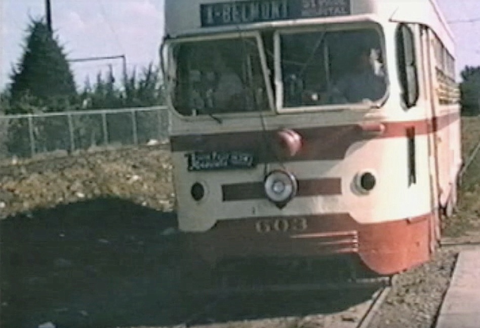
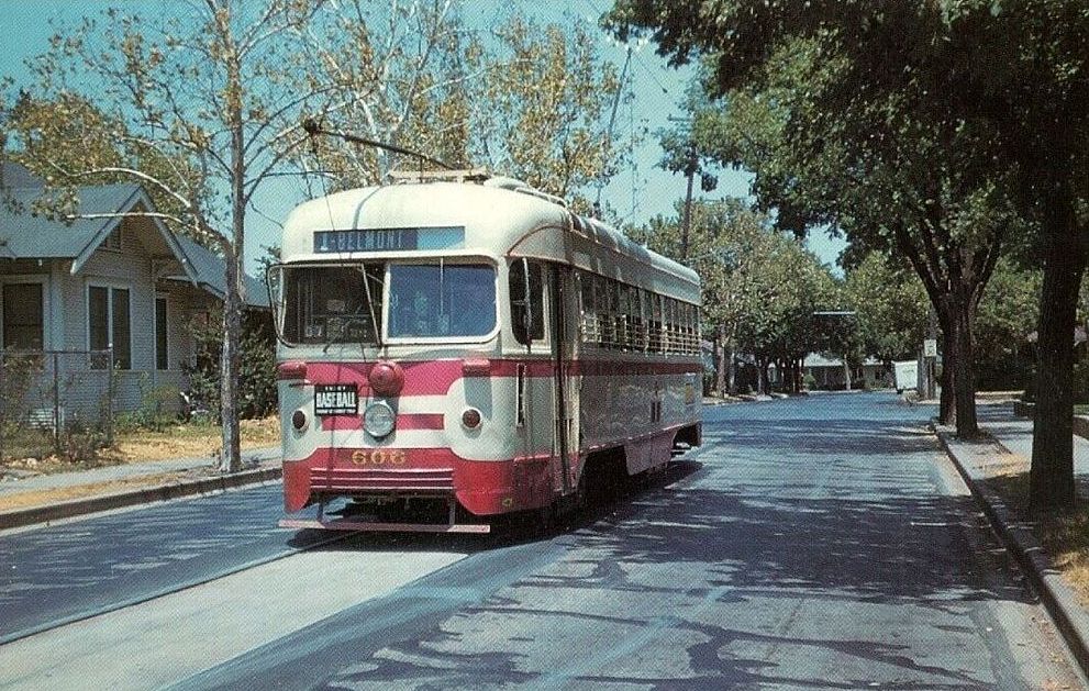
A few years ago I stumbled across the YouTube video below and was surprised to see actual footage of that streetcar rolling up Matilda. The first five minutes of the video contains 16mm footage (both black-and-white and color) shot around Dallas in 1953 and 1954 by Gene Schmidt. It’s GREAT! You’ll see streetcars-galore moving past all sorts of familiar and vaguely familiar sights around the city, from Oak Cliff to downtown to way out to Mockingbird and Matilda. It ends with the Belmont-Seventh car (car 603) pulling to the end of the line — the view is looking south down an unpaved Matilda Street from Mockingbird, with a glimpse of the Stonewall Jackson playing field at the left, on the other side of the fence. (The Matilda footage begins at 4:17.)
*
Matilda, south from Mockingbird, ca. 1954 (Gene Schmidt)
Above, a screen capture from the video showing Matilda looking south from just south of Mockingbird. Stonewall Jackson Elementary School is at the left. Today the view looks like this.
*
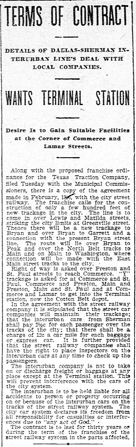
Before the streetcar arrived, Matilda was the artery that led the Texas Traction Company’s Sherman/Denison interurban into Dallas. This electric interurban service from the north, which closely followed the H&TC railroad line, arrived in Dallas in 1908, back when the official entry-point into the Dallas city limits was just off Matilda, near Greenville Avenue and Bryan Street.
DMN, Jan. 16, 1908 (click to read)
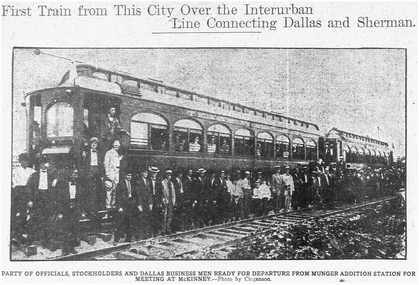
The interurban route connecting Sherman/Denison with Dallas opened on July 1, 1908 and lasted for 40 years, until its final run on December 31, 1948. (Read the Dallas Morning News article on the 1908 inaugural trip for big-wigs, “Many Make Trip Over Interurban,” July 1, 1908, here. Below is the accompanying photo. Image that running up and down Matilda — and, later, along other streets in Dallas — several times a day!)
DMN, July 1, 1908
Dallas’ ever-increasing population began to move northward and eastward, necessitating public transportation which would connect these developing areas with the rest of the city. One of the early “suburban” lines was the Belmont Line, which branched off the Bryan Street line and served the Belmont Addition and beyond; it opened in 1913, but these early days appear to have been more of a private “dinky” service (see SMU’s dinky car on the beyond-the-city-limits tracks at Hillcrest and McFarlin, here). The Belmont line — as well as the Vickery Place and Mount Auburn lines — became part of the city’s official streetcar system in 1922.
Before the dinky service, riders were able to get on and off the large interurban cars at stops between Mockingbird and the area around Bryan and Greenville Ave. Even though interurbans and streetcars were able to travel on the same rails, it took years for dedicated streetcar tracks to be laid along Matilda.
This detail of a real estate ad shows that the Belmont line had reached at least as far as Richmond by 1914 (I felt I had to include this because the finger is pointing at the exact location of the exposed rails in the photo at the top!):
May, 1914 (detail from Lakewood Heights real estate ad — see full ad here)
By 1922 the Belmont line had extended north to Velasco; by 1925 it had gotten to McCommas; by 1936 it had made it up to Penrose; and by 1939 it had finally reached Mockingbird (in time for the opening that year of Stonewall Jackson Elementary School, located at Mockingbird and Matilda).
Dallas streetcars began to be phased out in 1955, and the Belmont line was one of the first to go — its last run was March 6, 1955: “The Belmont-Seventh streetcar line will go out of existence Sunday to be replaced by service with new Diesel buses” (Dallas Morning News, March 6, 1955). The new bus route in the Lower Greenville area would, for the most part, be along Greenville Avenue, one block west of unpaved Matilda Street.
In March, 1955, it was reported that the abandoned Belmont-Seventh streetcar tracks were deeded to the city by the Dallas Railway and Terminal Co., with the understanding that they would eventually be paved over. The tracks were on Matilda, Bryan, Cantegral, Live Oak, St. Paul, King’s Highway, Edgefield, Seventh, Bishop, and Colorado. In April, 1956, it was reported that the City Council had approved the sale of the streetcar viaduct over the Trinity River and the Matilda street right-of-way.
But what about that paving of Matilda? Mrs. K. E. Slaughter had thoughts on the matter in a letter-to-the editor in April, 1955:
Since removal of the Belmont streetcar line in part — Matilda and Bryan streets — would it not be advantageous to develop this section into an important use to the heavy automobile traffic? Matilda now is no more than useless tracks built up between a cow path. (DMN, April 7, 1955)
“Cow path” — ha!
Another annoyed News reader wrote in 1963 — eight years after the tracks had been abandoned — about the useless unpaved thoroughfare:
The abandoned almost-private right of ways, such as Matilda, nearly two miles south from Mockingbird, received by the city in a deal to permit an all-bus operation, have not yet been paved or otherwise improved. (DMN, Oct. 21, 1963)
I’m not sure when that paving finally happened — early ’70s? — I think it must have been done in stages. I don’t remember a time when the stretch between Mockingbird and Kenwood wasn’t paved, but I do remember Matilda being a dirt road south of Kenwood. I don’t have a good recollection of the year, but kids remember all sorts of weird things, and those mysterious mounds were pretty memorable. (UPDATE: See photos of Matilda being paved at Goodwin in 1971 here.) I wish I’d known what an interurban was when I was a child. That would have made my neighborhood seem a whole lot more interesting! Heck, it used to the Gateway to Sherman!
I’ve long despaired of having missed the streetcar age. But it’s nice to know that one ran so close to the house I grew up in.
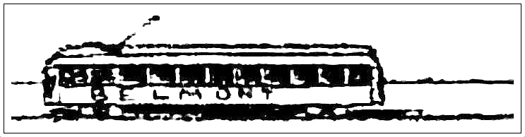
End of the line, ca. 1954… (Gene Schmidt)
***
Sources & Notes
Top photo taken by Dan Parr on April 15, 2018; it was originally posted to the Facebook group Dallas History Guild and is used here with permission. (Thanks, Dan!) The photo was taken at Matilda and Richmond, looking south on Matilda. See it on Google Street View, here. (Roadwork along Matilda is awful at the moment, but much-needed. Apparently it is being reduced to three lanes for automobiles with two bike lanes being added — read about it in the Lakewood Advocate, here.)
YouTube video shot by Gene Schmidt in 1953 and 1954; the direct link is here.
Another interesting video on YouTube was made by the City of Allen and contains period footage of the interurban that served North Texas. It’s a breezy 6-and-a-half minutes, and it includes some cool shots of Dallas.
If you want to see a whole bunch of North Texas interurban photos, check out this great 83-page PDF compiled by DART, “History of the Interurban Railway System and Monroe Shops,” here.
Speaking of DART, they posted a cool 1925 map of streetcar and interurban lines, here — click the map to see a larger image. (In 1925, the Belmont line ended on Matilda at McCommas).
ALSO extremely cool is a Google map showing Dallas’ Historical Streetcar (and Interurban) Lines laid over a present-day Google map, here. Zoom in and out. Very useful!

 4500 block and/or 5800 block of Lovers and/or W. Lovers Lane
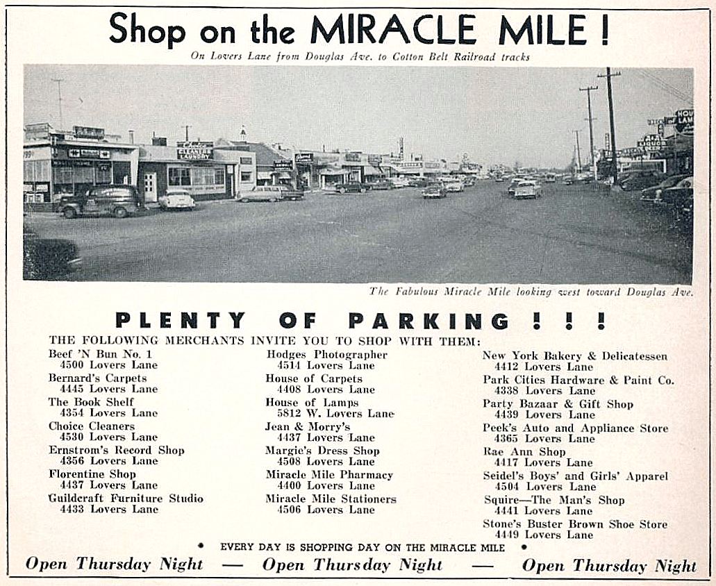
 *
*

 Head north, young man…