Flashback : Dallas

A Miscellany: History, Ads, Pop Culture

Tag: Historic Dallas

From the Vault: How Dallas Used To Get Election Returns

election-returns_1928_frank-rogers_dpl
Tight race.…

by Paula Bosse

It’s election time again. A post I wrote a couple of years ago on how people followed an evening’s election returns in the years before radio was a lot of fun to research. I bet you’ll learn some things you never even considered in the Flashback Dallas post from 2016, “How Dallas Used to Get Election Returns,” here.

Tuesday, Nov. 6, 2018 is election day across the country. Please VOTE!

*

Copyright © 2018 Paula Bosse. All Rights Reserved.

Happy Halloween from Karl Hoefle — 1955

halloween_hoefle_curiosities-blog_1955_med
Getting ready for the big day, polishing her broom…

by Paula Bosse

Before Karl Hoefle entered the consciousness of most Dallasites with his fun phone book covers, he was a hard-working commercial artist. This 1955 Halloween-themed drawing was done for a magazine cover, and, like those phone book covers, he rewards the observant viewer with lots of little jokes. It might help to zoom in and look at some of the details.

The first one is a little fuzzy, but the calendar is from the A-1 Witchcraft Supply House: “Everything for the discriminating witch. See the all-new ’56 jet broom with ‘floating ride.'”

halloween_hoefle_curiosities-blog_1955_det_calendar

The witch has some handy-dandy Bonson’s Broom Polish (“with added anti-sliver compound”).

halloween_hoefle_curiosities-blog_1955_det_broom-polish

Her bookshelf contains works such as My Ghoul in Life, the Encyclopedia of Witchcraft (Standard Revised Edition), and Haunting Melodies. And the smiling ghost portrait adds a nice homey touch.

halloween_hoefle_curiosities-blog_1955_det_bookshelf

A crumpled-up note on the floor reads “Call Merlin.”

halloween_hoefle_curiosities-blog_1955_det_merlin

Mice are scaring each other, and the V8 Jet Broom appears to be revving.

halloween_hoefle_curiosities-blog_1955_det_boo

Thank you, Karl!

halloween_hoefle_curiosities-blog_1955_det_sig

Happy Halloween!

***

Sources & Notes

This illustration by Karl Hoefle was drawn for the September-October, 1955 issue of Among Ourselves, a local publication for the Pollock Paper Corporation Employees. I found this image in an old post on the website of the fab establishment in Lakewood, Curiosities. The post from 2014 is here — it includes two more Among Ourselves covers by Hoefle.

I’ve written only one Karl Hoefle post so far: “1971 Yellow Pages Cover: SMU Gets the Karl Hoefle Treatment,” here.

More Halloween posts can be found here.

*

Copyright © 2018 Paula Bosse. All Rights Reserved.

Life on Hall Street — 1947

adolphus-bar-b-q_dallas-negro-directory_1947-48_dining-roomInterior of Adolphus Isaac’s Bar-B-Q Palace…

by Paula Bosse

Here are a few post-war ads for businesses in the 2200 and 2300 blocks of N. Hall, between Thomas and State, in the heart of “North Dallas,” a once-thriving business and entertainment district which catered to Dallas’ black community, until construction of Central Expressway sliced it in half a year or two after these ads appeared. These two blocks are completely unrecognizable today (a Google Street View looking north on Hall from Thomas can be seen here), and evidence that this area was once a lively African American neighborhood teeming with small businesses, cafes, and clubs exists almost entirely in old photos and ads like these.

Below, the LA CONGA CAFE, 2209½ Hall, S. H. Wilson, proprietor. “Where we serve you the best of foods. The home of Good Foods. Ice cold beer.” (All pictures are larger when clicked.)


la-conga_dallas-negro-directory_1947-48

THE ADOLPHUS BAR-B-Q PALACE, 2314 Hall, Adolphus Isaac (whose name in the ad appears to be misspelled), proprietor. “Always a friendly welcome. Steaks, fried chicken, fish, bar-b-q, frog legs [!], delicacies.”

adolphus-bar-b-q_dallas-negro-directory_1947-48

VASSELL’S JEWELRY STORE, 2317 Hall, Robert Vassell, proprietor. “Diamonds — watches — jewelry. Repairing reasonable, engraving a specialty.” This ad shows the “watch training school” Vassell operated in which WWII GI’s learned watch-repair.

vassells-watch-training-school_negro-directory_1947

NEGRO UNION COUNCIL, 2319 Hall. A group of black unionists shared space at 2319 Hall: the Negro Unions Council, the Musicians Protective Union Local 168 (whose former president was Theodore Scott seen in both photos below), Federated Labor (AF of L), Hotel & Restaurant Employees Intl. Local No. 825. (Ned L. Boyd, pictured below, was a pharmacist who owned Boyd’s Pharmacy a couple of doors down at 2311 Hall.)

negro-union-council_negro-directory_1947

American Federation of Musicians officials (and their hats) standing in front of 2319 Hall.

negro-union-council_musicians_negro-directory_1947

Below, the 1947 Dallas street directory, showing the businesses in the 2200 and 2300 blocks of N. Hall.

vassell_hall-st_1947-directory1947 Dallas directory (click to see larger image)

Below, a detail of a 1952 Mapsco page, with Hall Street in blue, Central Expressway (which hadn’t yet been built when the ads above appeared in 1947) in yellow, and the 2200 and 2300 blocks of Hall circled in red.

state-thomas_mapsco_1952
1952 Mapsco

As an aside, Roseland Homes seen in the map detail above, was a low-income public housing project for black residents, which opened in June 1942. It covered a 35-acre tract, with 650 units and was the first of many such housing projects for low-income black, white, and Hispanic families which opened that year, and it continues to this day.

***

Sources & Notes

Ads from the Dallas, Texas Negro City Directory, 1947-1948, with thanks to Pat Lawrence.

Read more about Hall Street — just a few blocks south, near Ross — in the Flashback Dallas post “1710 Hall: The Rose Room/The Empire Room/The Ascot Room — 1942-1975,” here.

*

Copyright © 2018 Paula Bosse. All Rights Reserved.

“Triple Underpass” by Florence McClung — 1945

mcclung_triple-underpass_1945_david-dike-fine-art“Triple Underpass” by Florence McClung (photo: David Dike Fine Art)

by Paula Bosse

The word “iconic” is used way too much these days, but I suppose Dallas’ triple underpass is something that truly deserves to be described as “iconic.” Aside from the beauty, the engineering, and the usefulness of the underpass/railroad bridge, it is also, of course, known around the world for its cameo appearance in the Kennedy assassination.

Built in 1936, after years of back-and-forth planning and negotiating, the triple underpass was open in time for the Texas Centennial Exposition. It finally opened up a straight shot from Fort Worth to Dallas via Highway 1, and it and the concurrently-built Dealey Plaza served as Dallas’ welcoming “gateway” into the city for visitors approaching from the west.

The 1945 painting seen above — “Triple Underpass” by Dallas artist Florence McClung (1894-1992) — may be one of the first depictions of the structure in a fine art context. This painting goes up for sale this weekend, as the featured lot in the David Dike Fine Art Texas Art Auction. The estimate is $75,000-$175,000. Florence would be shocked by that, as her original price — which she wrote on a checklist for a show at the then-Dallas Museum of Fine Arts was $300 (which would, today, be about $4,000). (UPDATE 10/27/18: The painting sold for $252,000 — which, I assume, includes the buyer’s premium.)

mcclung_1945-dma-show_checklist-portal_cropped

As a fan of Texas art — and especially of the Dallas regionalist group, the Dallas Nine (with which McClung, though not a member, was closely associated) — I hope this wonderful piece of Dallas art (and you can’t get much more quintessentially Dallas than this!) goes for much more than the gallery estimate. (I wrote about McClung previously, here, with images showing a couple of other Dallas “cityscapes” done around the same time as “Triple Underpass.”)

*

Below is a photo from 1945 showing an aerial view of the scene captured by McClung that same year. (A photo from a little later, with a view to the west, is here.)

triple-underpass-1945
Dallas, 1945 (click for larger image)

A few things are interesting to me:

  • McClung neglected to include the ever-present billboard atop what was then the Sexton Foods building (later the School Book Depository) — in the photo above, U. S. Royal tires are being advertised.
  • I love that little oval, landscaped island, which is also seen in McClung’s painting.
  • Those four obelisk-y pillars, seen in both the photo and the painting, two on either side of the roadway, west of the underpass — what are those?
  • Is that large white building in the lower middle of the photograph Pappy’s Showland? Maybe the Sky-Vu Supper Club (which I have meant to write about for years)? (No! It’s the Chicken Bar, at the northeast corner of Commerce and Industrial. A photo of it under construction in 1945 is here.)

See here for as close to the angle of McClung’s view as I could get, from a 2014 Google Street View. (The painting shows the Dallas County Courthouse as it was then, without its now-replaced tower.)

**

Good luck to the bidders this weekend. It’s a great painting!

dike-gallery_catalog-cover_oct-2018

***

Sources & Notes

Image of Florence McClung’s painting “Triple Underpass” is from the David Dike Fine Art catalog, which is illustrated with the works to be auctioned on Saturday, October 27, 2018; the catalog can be viewed in its entirety, here (this painting and its description are on p. 45). The website of David Dike Fine Art is here. The prices realized for this auction can be found here — McClung’s painting is Lot 163.

I am unsure of the source of the 1945 aerial photo — I saved it years ago and did not make note of the source, although I highly suspect it is from one of the many fine collections held by SMU.

See McClung’s application for the DMFA show where “Triple Underpass” was shown, here; her checklist of works to be shown is here (both documents are from the Dallas Museum of Art’s Exhibition Records, via UNT’s Portal to Texas History).

The earlier Flashback Dallas post “Dallas Scenes by Florence McClung — 1940s” (with two other paintings from the same period as “Triple Underpass”) is here.

*

Copyright © 2018 Paula Bosse. All Rights Reserved.


Casa View Elementary/Casa View Park — 1954-1974

casa-view-elementary_park_aerial_squire-haskins_1954_dallas-municipal-archives_portalCasa View Elementary and next-door park, 1954 (click for larger image)

by Paula Bosse

I wrote about Casa Linda Park not long ago, so today … Casa View Park (and its neighbor, Casa View Elementary School).

After World War II, there was a severe housing shortage in Dallas, and developers began looking to areas which offered new land to build on and were ripe for annexation. One such area — east of White Rock Lake and beyond the city limits — was eyed as a prime site for a new residential neighborhood: it didn’t take long for the area now known as Casa View to pop up.

One of Casa View’s neighborhoods was Casa View Heights (which, roughly, is bounded by Garland Road, Centerville Road, Shiloh Road, and … maybe Barnes Bridge? — see ad below) — it was a development spearheaded by Carl Brown, whose nearby Casa Linda development had been a big hit. The land this addition was built on was annexed by the City of Dallas in 1949. In mid-1950, it was announced that “ten acres of pasture land north of Centerville Road in the Casa View area” had been purchased by the Dallas School Board, a tract which “some day may be the site of a school […] though the school building program has no project scheduled for the area” (“Sizable Land Plots,” Dallas Morning News, July 16, 1950).

About half that parcel of land became Casa View Park sometime in 1950; the other half became the campus of Casa View Elementary School. The school (designed by premier Dallas architect Mark Lemmon) began construction in 1952 and was ready for use by the opening of the new school year in 1953 (enrollment on the first day was an impressive 870 students).

Below are four aerial photos showing the Casa View park and school, taken over a 20-year period by Squire Haskins. (All images are larger when clicked.)

*

At the top: a photo from 1954, with the year-old Casa View Elementary School on the left (in its original square shape, with an unusual-for-the-time open courtyard in the center); the fairly bleak-looking, treeless Casa View Park is on the right. The view is to the west, with Farola at the top, Monterrey on the left, and Itasca at the bottom and right.

Below, from January, 1966 — a view toward the south:

casa-view-elementary_park_aerial_squire-haskins_jan-1966_dallas-municipal-archives_portal

November, 1969 — looking west:

casa-view-elementary_park_aerial_squire-haskins_nov-1969_dallas-municipal-archives_portal

August, 1974 —  looking east:

casa-view-elementary_park_aerial_squire-haskins_aug-1974_dallas-municipal-archives_portal

*

Below, with annexation under their belt (and assurance of city services, schools, etc.) developers’ ads like this one began appearing in local newspapers, hoping to entice prospective homeowners to the brand new “Casa View Heights” addition. (The description of these modest homes as “luxury” was a bit of a stretch….) 

casa-view-heights_103049_adOctober, 1949

Here are a couple of interesting pages from the 1952 Dallas Mapsco. Take a look at all that empty white space just waiting to be gobbled up by an ever-sprawling Big D. (The location of the park and school is marked in the second image.)

casa-view_mapsco-1952a


casa-view_mapsco-1952b_marked

***

Sources & Notes

The aerial photos are from the Dallas Municipal Archives, and are included in the collection “Dallas Parks Aerial Photographs” provided to UNT’s Portal to Texas History site; all photos above can be found here.

The location of the school and park can be seen here. A present-day aerial view from Google is here.

*

Copyright © 2018 Paula Bosse. All Rights Reserved.


Nighttime Bird’s-Eye Views of Dallas

skyline_legacies_spring-2012All lit up…

by Paula Bosse

In my opinion, Dallas has always been most impressive at night. The view above is from the east. Among other familiar landmarks, we see skyline icons the Mercantile Building, the Sheraton Hotel, the Southland Life Building (at the time the city’s tallest building), and the rocket-topped Republic Bank Building (previously the city’s tallest building). I think that’s Live Oak St. on the left running in and out of downtown and Bryan on the right.

And, below, a view toward the east, with Jackson Street on the right, and dramatically-lit appearances by the Adolphus Hotel, the Magnolia Building, the Baker Hotel, and the Mercantile.

skyline_legacies_spring-2012_postcard

***

Sources & Info

These postcard images were featured on the front and back covers of the Spring, 2012 issue of Legacies magazine (viewable on UNT’s Portal to Texas History site, here).

A similar photo (colorwise) to the second image above (but taken from a rotated angle) can be found in the Flashback Dallas post “Dallas Skyline At Night — ca. 1965” — this photo shows the skyline just a few short years later after the new Republic Tower II had appeared on the horizon and claimed the title as the city’s tallest building — the Southland Life Building’s reign was only about five years long..

*

Copyright © 2018 Paula Bosse. All Rights Reserved.

The State Fair of Texas Over the Decades

state-fair-of-tx_midway_kodachrome_1961_ebay
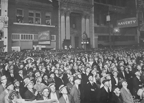
SFOT midway, 1961… (click for larger image)

by Paula Bosse

The history of the State Fair of Texas is also the history of Dallas — if you live in Dallas, you know a lot about the fair, if only by osmosis. Here are a few images from the decades since the fair began in 1886.

Below, from 1889, a sedate advertisement for the Texas State Fair and Dallas Exposition (from The Immigrant’s Guide to Texas, 1889). (All images are larger when clicked.)

state-fair_imm-gd_1889

*

A great-looking poster from 1890, colorful and exciting:

sfot_poster_1890

*

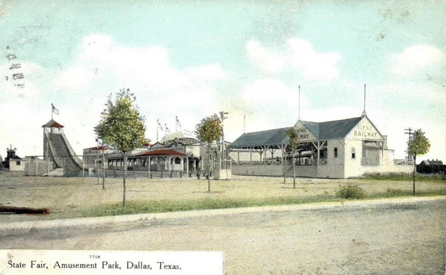
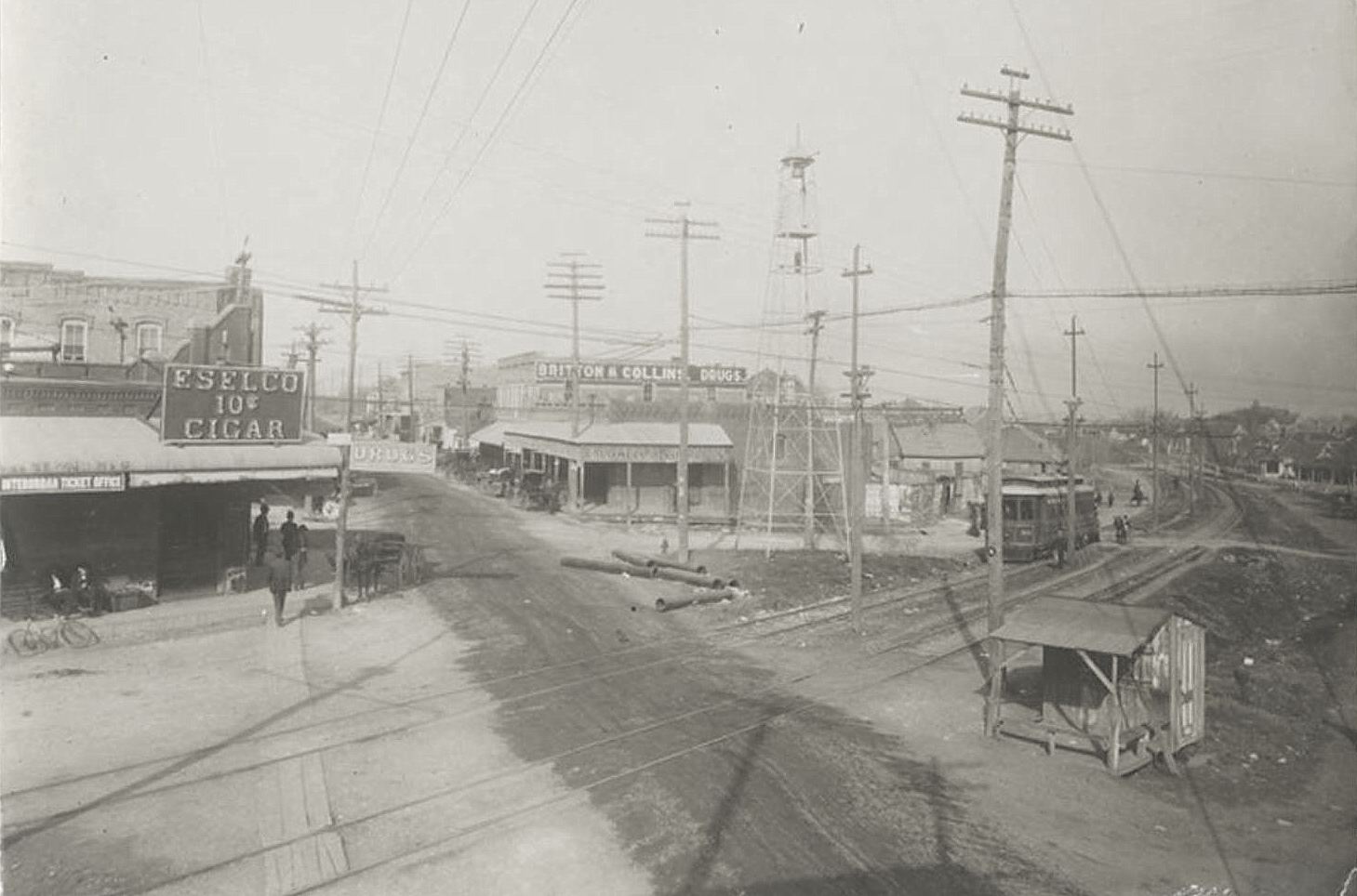
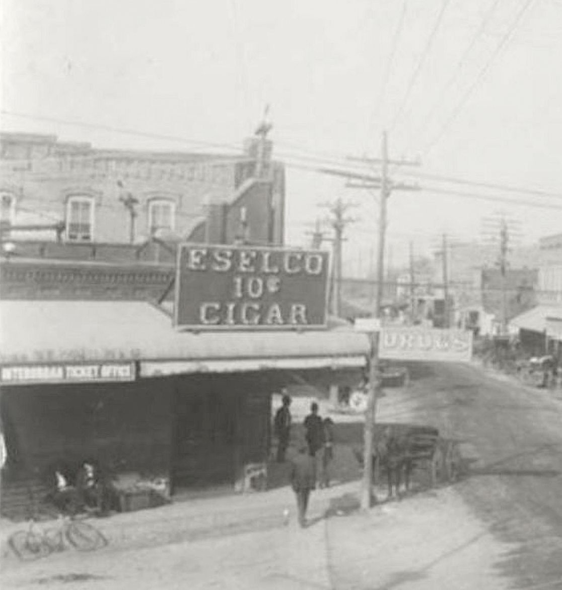
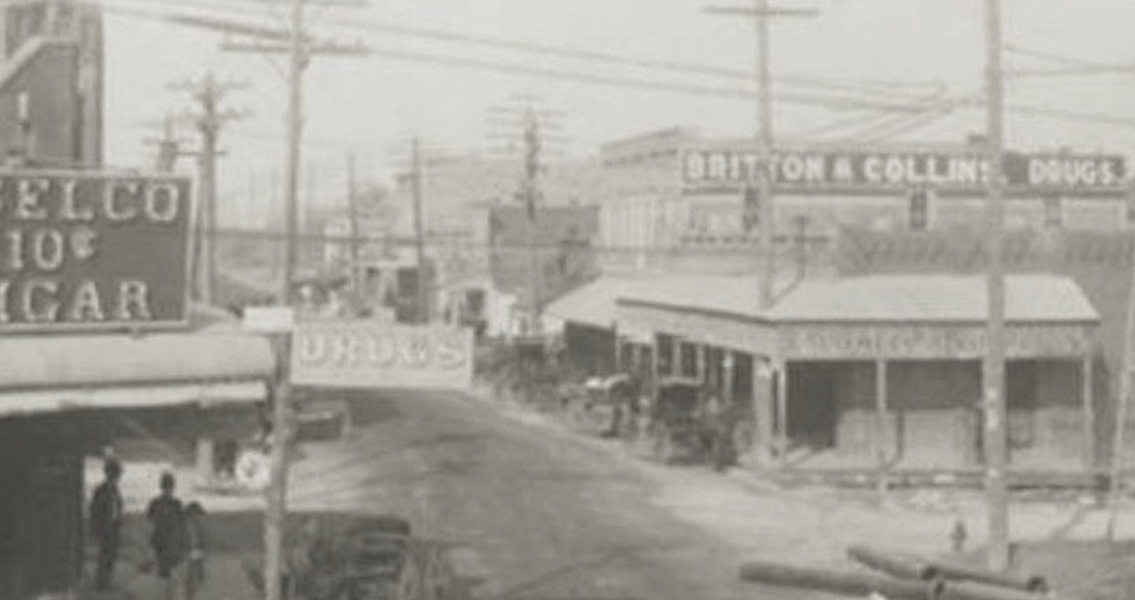
A midway in its infancy, in the aughts. (I wrote about the “The Chute” water ride, here.)

shoot-the-chute_postcard_ca-1906

*

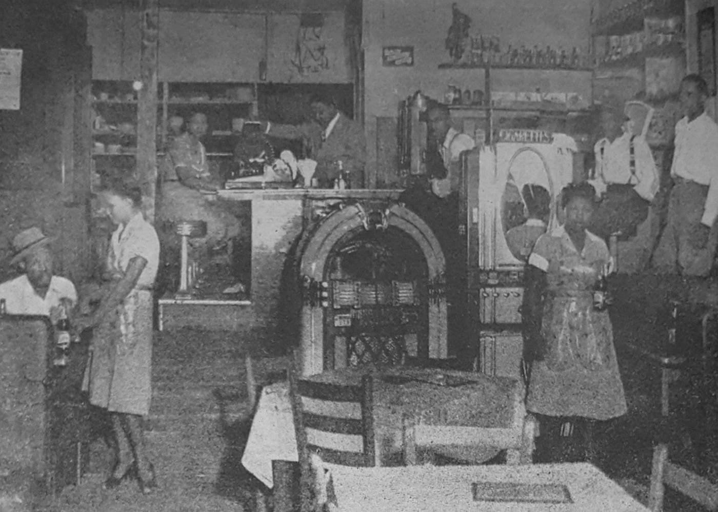
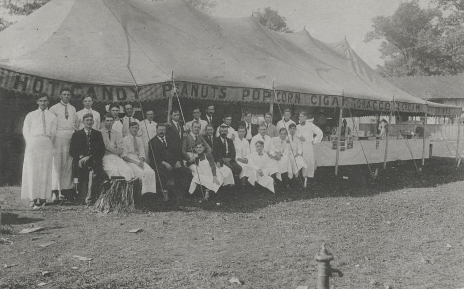
Here’s a group photo showing the food vendors at the 1910 fair. No corny dogs in 1910, but plenty of candy, peanuts, popcorn, ice cream, and, sure, why not, cigars and tobacco.

state-fair-concessionaires_1910_cook-colln_degolyervia George W. Cook Collection, DeGolyer Library, SMU

*

In the 1920s, Fair Park looked a lot smaller:

fair-park_mcafee_degolyer_SMU_ca-1920s
via George A. McAfee Collection, DeGolyer Library, SMU

Here’s a handy 1922 map of the grounds, from the fine folks at Caterpillar (don’t miss those tractors!) — you can see where the people in the photo above are walking.

state-fair-map_caterpillar_ad_1922

*

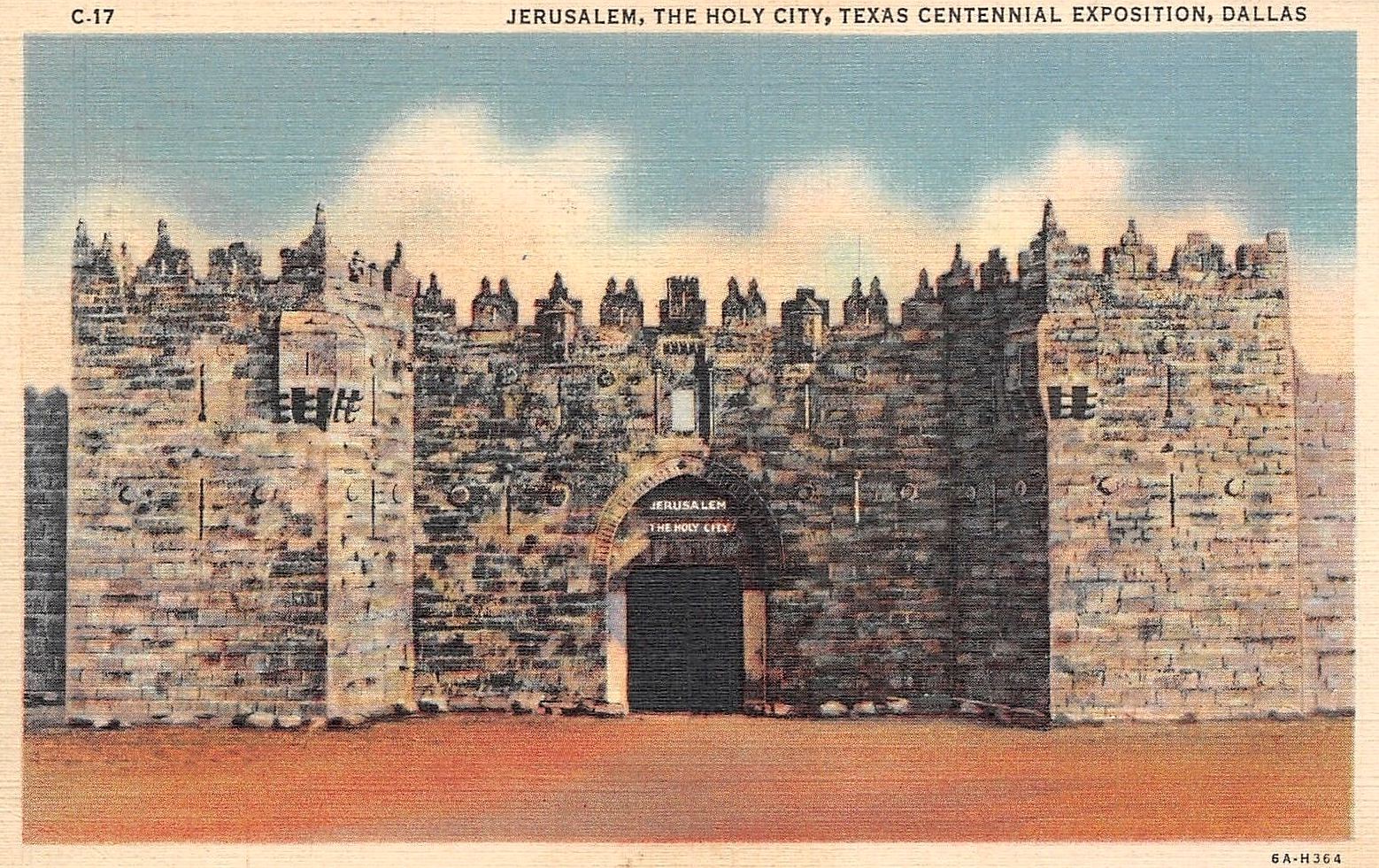
If it’s 1936, it’s gotta be the Texas Centennial — and here’s an exhibit I’d never heard of: Jerusalem, The Holy City. This was one of many exhibits at the Texas Centennial previously seen at the 1933 Chicago World’s Fair, where it apparently had attracted more than one million visitors. In the weeks leading up to the Centennial’s opening, it was described thusly: “The Holy City will contain a collection of religious artworks and other material. The entrance will represent the Damascus gate of Jerusalem. No admission will be charged but donations will be asked visitors” (Dallas Morning News, May 17, 1936).

tx-centennial_jerusalem-the-holy-city_postcard

*

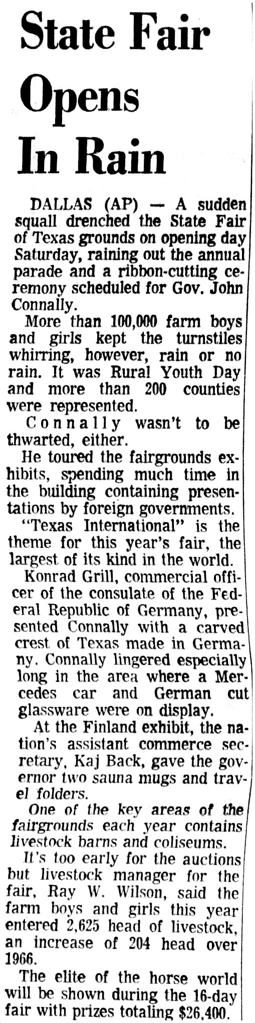
The State Fair of Texas was not held during much of World War II, but it was back in 1946, with Tommy Dorsey, Gypsy Rose Lee, and Jackie Gleason.

state-fair_sept-1946_ad-cow
Sept., 1946

*

Neiman-Marcus was at-the-ready in 1950 with suggestions on stylish footwear for ladies wanting to trudge around the Fair Park midway in heels.

For the Million-Dollar Midway — For taking in this famous “main drag” of the State Fair — get into our famous-maker midway heel shoes. Most everybody — after walking a block or two in them — says they’re worth a million! Have all the comfort of low heels, plus the high-heel’s way of making your ankles look prettier.

sfot-neiman-marcus_ad_101650October, 1950

*

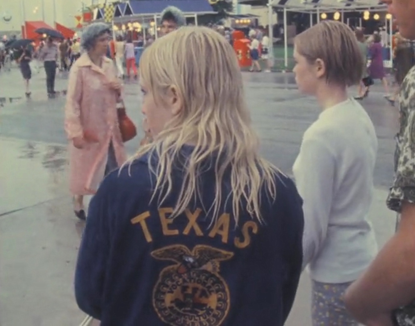
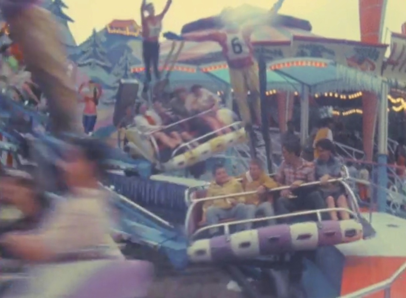
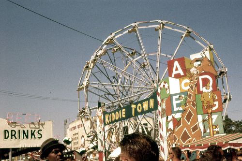
The 1960s were certainly colorful, and this is a great color photo from 1961 (currently available on eBay as a 35mm Kodachrome slide) — it’s the photo at the top of this post, but in order to cut down on unnecessary scrolling, I’ll slide it in again right here:

state-fair-of-tx_midway_kodachrome_1961_ebay

*

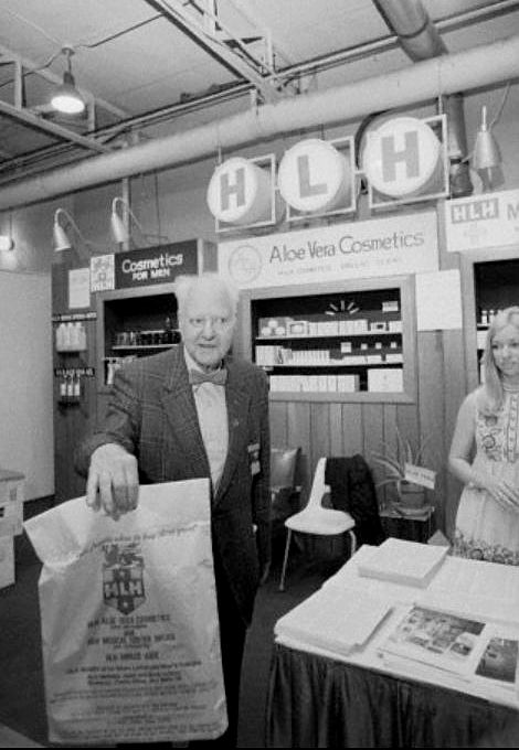
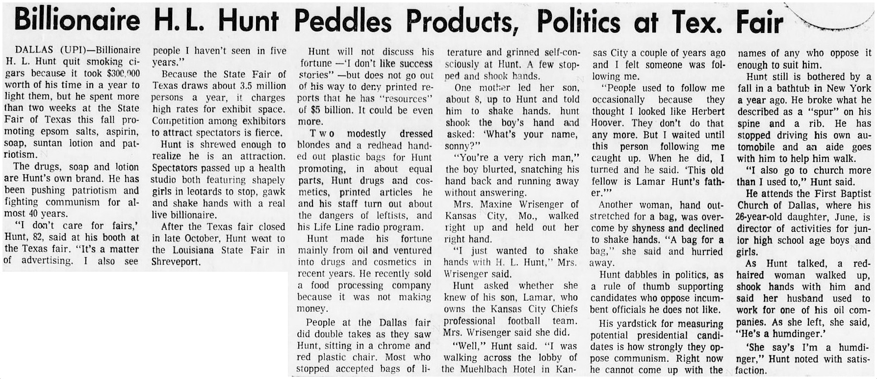
The 1970s was a weird decade, and what better way to start off a weird decade than with 80-something-year-old oil tycoon (and eccentric Dallas resident) H. L. Hunt handing out cosmetics at a booth at the State Fair? Hunt — whom Frank X. Tolbert described as “probably the world’s only billionaire health freak” — manufactured a line of cosmetics and other products containing aloe vera, the wonder elixir. Imagine seeing the world’s richest man handing out plastic goodie-bags to awe-struck passersby. Like I said, weird.

h-l-hunt_state-fair_1971

hunt_state-fair_pomona-progress-bulletin_CA_111471Pomona (CA) Progress-Bulletin, Nov. 14, 1971 (click to read)

*

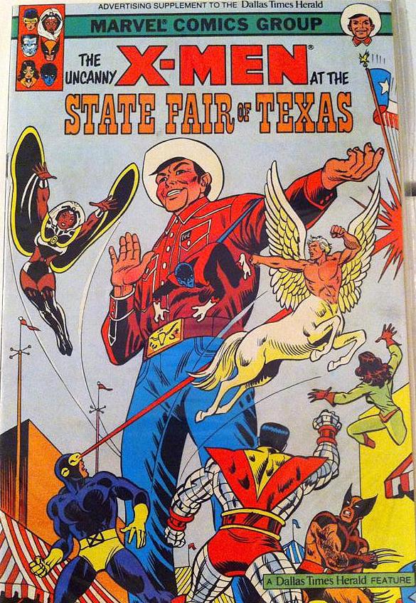
And, finally, the 1980s. A century after the State Fair of Texas began, the X-Men came to Big D to do whatever it is they do — and The Dallas Times Herald got a cool little advertising supplement out of it. (If this appeals to you, check out when Captain Marvel came to Dallas in 1944, here, and when Spider-Man came to Dallas in 1983, here.)

sfot_xmen_comic-book_1983

***

Sources & Notes

Sources (if known) are noted.

All images are larger when clicked.

I wrote a similar State-Fair-of-Texas-through-the-ages post a few years ago: “So Sorry, Bill, But Albert Is Taking Me to the State Fair of Texas,” here.

*

Copyright © 2018 Paula Bosse. All Rights Reserved.

10th and Lancaster, Oak Cliff — ca. 1902

oak-cliff_tenth-and-lancaster_mcafee_degolyer_SMU_ca-1902Lancaster, intersecting Jefferson & E. 10th… 

by Paula Bosse

This photo, taken around 1902, shows a northward-view of an intersection of the (then) soon-to-be-annexed (or a just-annexed) Oak Cliff: Lancaster (the dark road running at a slight diagonal to the upper left of the photo), E. 10th St. (crossing Lancaster behind the “Eselco 10¢ Cigars” sign and running horizontally in the middle of the photo), and Jefferson, which contains the double tracks of the then-new Dallas-Fort Worth interurban railway.

The location of this photo can be seen on a 1905 Sanborn map here (in that map, 10th St. is at the right edge — to see the area just south of Jefferson — where the photographer snapped his photo — that map is here). The view today? Lancaster (which became N. Lancaster just north of E. 10th) no longer exists immediately north of 10th — that land is now occupied by Hector P. Garcia Middle School  — the location seen in the 116-year-old photo above can be viewed on Google Street View, here.

Let’s zoom in on this photo. Though grainy, it’s still really exciting to see views of Oak Cliff, just after the turn of the century (Oak Cliff was annexed by Dallas in 1903 but had been a thriving community for many years before that). Below, a couple of men are seated on a bench beneath a sign that says “Interurban Ticket Office,” a bicycle lies at the curb, men stand on the corner, and a horse-drawn buggy is parked underneath a sign that says “drugs.” Eselco brand cigars were ten cents apiece at the time (about $3.00 in today’s money). The “ticket office” sign helps date this photo, as the Dallas-Fort Worth interurban service (through Oak Cliff) began in July, 1902. (All photos are larger when clicked.)

oak-cliff_tenth-and-lancaster_mcafee_degolyer_SMU_ca-1902_det-1

On the east side of Lancaster, a two-story building with “Britton & Collins Drugs” painted on the side dominates the block. The drug store was owned by T. Jefferson (“Jeff”) Britton and J. Willie Collins. Tennessee-born Britton (1874-1926) had opened a well-known drug store in downtown Dallas at the southeast corner of Elm and Akard in the late 1890s (seen here in 1900) — this attempt at an expansion into Oak Cliff does not seem to have lasted long: I find listings for this OC location in only the 1902 and 1903 city directories.

oak-cliff_tenth-and-lancaster_mcafee_degolyer_SMU_ca-1902_det-2

britton-and-collins-drug-store_1902-directory1902 Dallas city directory

Back to the interurban service (the arrival of which was, no doubt, both a welcomed convenience as well as a financial boon to Oak Cliff residents and businesses): here are the double tracks of the Northern Texas Traction Co., running along Jefferson. (More on this interurban line is at the bottom of this post.)

oak-cliff_tenth-and-lancaster_mcafee_degolyer_SMU_ca-1902_det-3

Below is a detail from a 1905 map showing this confusing intersection of E. 10th, Jefferson, N. Lancaster, and S. Lancaster. (As with all images in this post, click to see a larger picture.)

oak-cliff_tenth-and-lancaster_worleys-map-greater-dallas_1905_det

***

Sources & Notes

This photo — titled “10th and Lancaster, Oak Cliff, 1900” — is part of the George A. McAfee photographs collection, DeGolyer Library, Southern Methodist University; more information about this photo can be found here.

According to the DeGolyer Library, the photo has the following notation written on the back: “10th & Lancaster. Oak Cliff — looking toward Dallas. Taken 1900.” I think the photo was taken a little later — somewhere between mid-1902 and very early 1904: the Britton & Collins drug store was listed in only two Dallas directories (1902 and 1903), and the interurban service from Dallas to Fort Worth (which passed through Oak Cliff and past the “Tenth St. Station”) did not begin until July, 1902.

Everything you could possibly want to know about the Dallas-Fort Worth interurban line, including mechanical specs and several photographs, can be found in a PDF of the July 18, 1903 issue of the Street Railway Journal, here (scroll down to the link for the specific issue) (the 10-page article “The System of the Northern Texas Traction Company” begins on p. 82 — lots in this article on “Lake Erie” at Handley).

A few newspaper snippets from the first month following of the launch of the Dallas-Fort Worth interurban service.

oak-cliff_interurban_dmn_070102Dallas Morning News, July 1, 1902 (click to see larger image)

oak-cliff_interurban_dmn_070702_first-week-operationDMN, July 7, 1902

The one-way fare to FW from Dallas was 70¢, and a round-trip fare was $1.25 (a rather hefty $20 and $36, respectively, in today’s money, adjusted for inflation).

oak-cliff_interurban_tenth-station_dmn_071702DMN, July 17, 1902

oak-cliff_interurban_tenth-station_dmn_071102DMN, July 11, 1902

oak-cliff_interurban_el-paso-herald_072102El Paso Herald, July 21, 1902

*

Copyright © 2018 Paula Bosse. All Rights Reserved.

A Rainy Opening Day of the State Fair of Texas — 1967

sfot_rain_1967_wbap_unt_fair-park_texas-carthageA damp day at the fair… (click for larger image)

by Paula Bosse

It’s  been raining pretty heavily today. And the State Fair of Texas is underway. I always feel bad for the people visiting and working at the fair when it rains like this. What a disappointment!

It rained so much on Opening Day of the State Fair in 1967 that the downtown parade ended up being canceled, as did the ceremonial ribbon-cutting which was to have been performed by Governor John Connally. That day — Oct. 7, 1967 — was also Rural Youth Day, and newspaper reports estimated that more than 100,000 “farm boys and girls” from more than 200 Texas counties had traveled to Dallas for what turned out to be a soggy day at the fair. (But kids never seem to mind being out in the rain as much as adults do.)

Watch rainy footage of the parade preparations downtown and wet-haired teenagers at the fair in an atmospheric clip shot by WBAP Channel 5 News cameramen, collected and digitized by UNT (see bottom of this post for more info). The 1:47 film footage can be viewed here (be sure to watch it in full-screen mode).

Below are a few screenshots.

sfot_rain_1967_wbap_unt

At the top, a girl from Carthage, wearing a Future Farmers of America jacket (it was Rural Youth Day, and the FFA was well represented) as well as a couple of ladies in coif-preserving plastic rain bonnets.

Below, a rain-drenched downtown.

sfot_rain_1967_wbap_unt_street

El Chico float getting soaked.

sfot_rain_1967_wbap_unt_el-chico-float

Marching band guys taking shelter.

sfot_rain_1967_wbap_unt_band_mkt

Grandma as human umbrella.

sfot_rain_1967_wbap_unt_boy_grandmother

Quadrupedestrians. (Pretty sure horses shouldn’t be trotting along sidewalks….)

sfot_rain_1967_wbap_unt_horses_sidewalk

A break in the precip — rides are revved up.

sfot_rain_1967_wbap_unt_fair-park_ride

Menacing clouds as seen from the top of the Comet.

sfot_rain_1967_wbap_unt_fair-park_top-of-roller-coaster


sfot_rain_san-antonio-express-news_100867
San Antonio Express-News, Oct. 8, 1967

***

Sources & Notes

Screenshots are from the video titled “News Clip: 1967 Texas State Fair Begins, Parade Rained Out.” It is part of the KXAS-NBC 5 News Collection and was provided by UNT Libraries Special Collections to The Portal to Texas History, a digital repository hosted by the UNT Libraries. More info — including the video itself — can be accessed here.

More rainy-day SFOT weather can be seen in this clip from 1970, courtesy of SMU.

*

Copyright © 2018 Paula Bosse. All Rights Reserved.

Casa Linda Park — 1947-1977

casa-linda_aerial_baseball-diamond_squire-haskins_072047_dallas-municipal-archives_portalThe idyllic Casa Linda countryside, 1947…

by Paula Bosse

Here are several aerial photographs, taken over a 30-year span, showing Casa Linda Park, located east of White Rock Lake — most (if not all) were taken by noted Dallas photographer Squire Haskins. When the little 6.3-acre park opened in 1947, it was described by The Dallas Morning News as “rustic and picturesque” (DMN, Aug. 19, 1947), a description which could be used for the whole Casa Linda area which was being developed at the time by Carl Brown.

The land for Casa Linda Park was purchased by the City of Dallas in March, 1947, and it is bounded by Old Gate Lane on the southwest, the curving San Saba Drive on the north, and what used to be the Santa Fe Railway railroad tracks on the southeast, between White Rock Lake and Buckner Blvd. I’m not exactly sure where Little Forest Hills ends and Casa Linda begins, but both neighborhoods could claim this cute little park as their own, I suppose.

These aerial photos are from the Dallas Municipal Archives, via the Portal to Texas History (links can be found at the bottom of this post). All photos are larger when clicked. See your house?

At the top, the earliest photo of the park in this collection, taken in July, 1947 by Squire Haskins.

Below, the second Haskins photo, from 1954:

casa-linda_aerial_baseball-diamond_squire-haskins_1954_dallas-municipal-archives_portal

Below, another Haskins photo, from January, 1966:

casa-linda-park_aerial_baseball-diamond_squire-haskins_jan-1966_dallas-municipal-archives_portal

Another Haskins photo, from July, 1970:

casa-linda_aerial_baseball-diamond_squire-haskins_july-1970_dallas-municipal-archives_portal

And lastly, a photo by an unidentified photographer, from July, 1977 — 30 years to the month after the photo at the top was taken:

casa-linda-park_aerial_july-1977_dallas-municipal-archives_portal

*

An aerial Google view of the park today can be seen here.

***

Sources & Notes

These photos are from the Dallas Municipal Archives, and are included in the collection “Dallas Parks Aerial Photographs” provided to UNT’s Portal to Texas History site; all photos above can be found here.

See aerials of nearby Casa View Park — taken by Squire Haskins between 1954 and 1974 — in the Flashback Dallas post “Casa View Elementary/Casa View Park — 1954-1974,” here.

*

Copyright © 2018 Paula Bosse. All Rights Reserved.