Flashback : Dallas

A Miscellany: History, Ads, Pop Culture

Category: Transportation

Dallas Rapid Transit, Est. 1888

dallas-rapid-transit_cyclone_cook-coll_degolyer_smu-detRide the Cyclone to Fair Park… (click for larger image) 

by Paula Bosse

The Dallas Rapid Transit Railway chugged into town in 1888, going from charter to operation in seven months. And that included laying their own track. The “dummy” steam engine (a locomotive designed to appear more like a friendly little streetcar and less like a hulking locomotive) seen above, carried passengers from the Windsor Hotel at Commerce and Austin through South Dallas (via S. Lamar and Forest Ave., now MLK Blvd.) to Fair Park. It started business just in time to ferry crowds to the State Fair. The fare was 20 cents, which seems pricey, but this might have been “surge” pricing charged only during the “Greatest Fair and Exposition in the World.” (According to the Inflation Calculator, 20¢ in 1888 would be the equivalent to more than $5 in today’s money.)

ad_dallas-rapid_dmn_101488
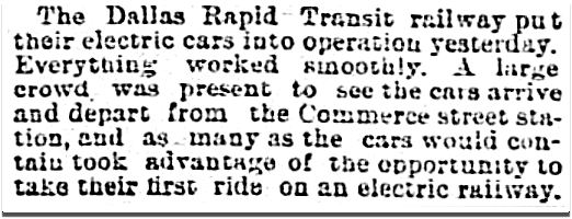
Dallas Morning News, Oct. 14, 1888

The new street railway was particularly appreciated by developers looking to sell land in southern Dallas, still considered a “suburb” in the 1880s. Residential streetcar service was essential to prospective builders and buyers, and as soon as the Rapid Transit line was up and running, its name was popping up in South Dallas real estate ads for additions with names like Chestnut Hill, Edgewood, and South Park.

chestnut-hill_edgewood_dmn_031689
DMN, March 16, 1889

In March of 1890 — after a year and a half of steady growth — the Dallas Rapid Transit Railway went electric, tossing out their old steam-powered cars (not even 18 months old!) for brand new, ultra-modern cars powered by electricity. (For a bit of perspective, parts of the country were still relying on the really old-fashioned mule-drawn streetcars.) Dallas’ first electric-powered streetcar hit the rails on March 9, 1890.

dallas-rapid_dmn_031090_electric
DMN, March 10, 1890

Understandably, the sight of these newfangled streetcars was quite the topic of fascinated conversation. How exactly did they work, anyway? The Dallas Morning News published an article with helpful information for the Dallasites of 1890 (and 2016!). (Click to see larger image.)

dallas-rapid_dmn_032390_electric
DMN, March 23, 1890

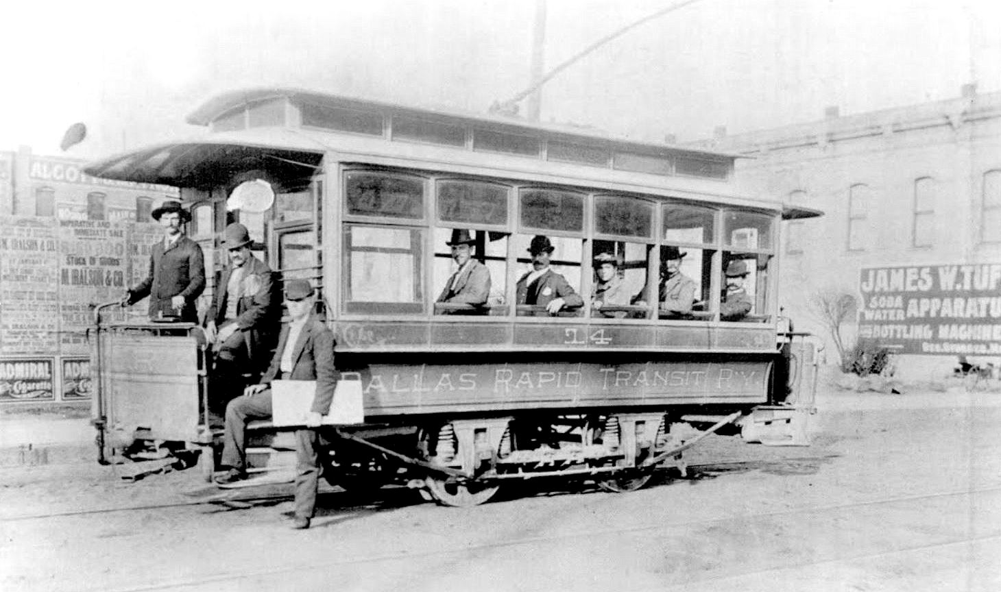
The photo below (which appears in the great book McKinney Avenue Trolleys) is a staged publicity photo with a woman at the helm, showing that the new electric streetcar was so easy to operate that “even a woman” could do it. In tow behind the sparkling new electric streetcar was the old, past-it steam car, with its engineer racing to try to catch up with the new technology. Get with it, man, it’s 1890!

dallas-rapid-transit-railway_mckinney-ave-trolleys-bk_towing-dummySouthern Traction, April 10, 1973 (via McKinney Avenue Trolleys)

dallas-rapid-transit-railway_mckinney-ave-trolleys-bk_dplDallas Public Library photo (via McKinney Avenue Trolleys)

Initially, the track was only 4 miles long, but that had more than doubled soon after the switch to electric cars.

dallas-rapid-transit_dmn_100190
DMN, Oct. 1, 1890

Things seemed to be going well. The company was expanding, speeds were increasing, and … “No dust” !

dallas-rapid_dmn_102791
DMN, Oct. 27, 1891

But … in 1894 the company went into receivership and was sold in December of that year for $35,000.

dallas-rapid_dmn_120594
DMN, Dec. 5, 1894

It appears that the company struggled on under different owners and slightly different names through at least 1909, but instead of those twilight years being filled with reflective contemplation and bass fishing, they were spent mired in endless lawsuits.

But let’s not dwell on the sputtering end of a business — let’s look back to the beginning, when the H. K. Porter Co. of Pittsburgh, Pennsylvania was proud to show off its new light locomotive with the noiseless steam motor which was headed, full of hope and enthusiasm, for the little city that could, Dallas, Texas.

dallas-rapid-transit_cyclone_cook-coll_degolyer_smu

dallas-rapid_dmn_032288
DMN, March 22, 1888

dallas-rapid_dmn_091088
DMN, Sept. 10, 1888

**

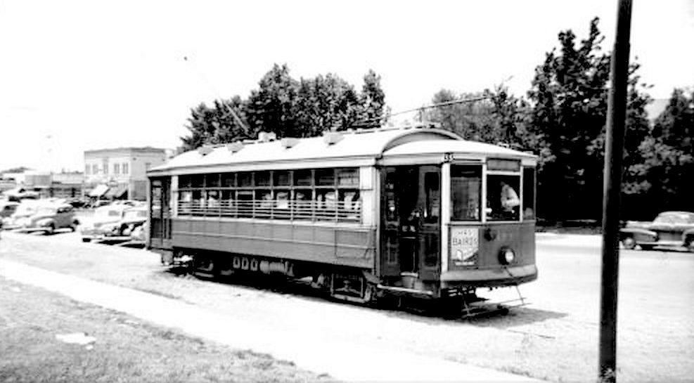
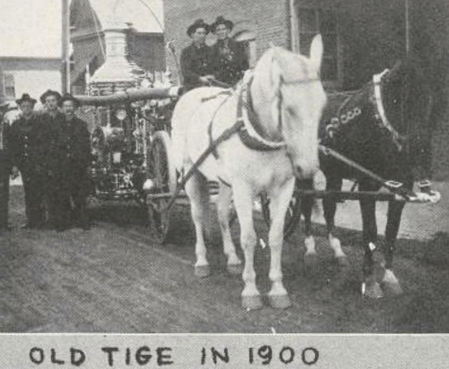
The steam-powered Cyclone — seen at the top — went on an adventure through the streets of downtown in 1889 when, under a full head of steam, it jumped the tracks and kept on going down paved streets until it crashed into a curb on Main!

cyclone_dmn_043089
DMN, April 30, 1889

***

Sources & Notes

Image at the top (and bottom), “Dallas Rapid Transit, ‘Cyclone’ Locomotive No. 1,” from the George W. Cook Dallas/Texas Image Collection, DeGolyer Library, Southern Methodist University; more information here.

Read an interview with J. E. Henderson, president of the Dallas Transit Railway company, commenting on his new street railway (“The New Rapid Transit,” DMN, Oct. 14, 1884) here (yes, it IS difficult to read!).

The two photos of Dallas Rapid Transit electric streetcars are from the book McKinney Avenue Trolleys by Jim Cumbie, Judy Smith Hearst, and Phillip E. Cobb (Charleston: Arcadia Publishing, 2011). If you’re interested in this topic, this book seems pretty essential!

The history of early streetcars in Dallas can be read in the  pages of the WPA Dallas Guide and History here (scroll to the bottom of the page and continue to the following page).

Photos and clippings are larger when clicked.

*

Copyright © 2016 Paula Bosse. All Rights Reserved.


Pacific Avenue: Watch for Trains! — ca. 1917

pacific-akard_park-cities-photohistory_frank-rogersToo close for comfort…

by Paula Bosse

Some people don’t realize that Pacific Avenue used to be lined with the railroad tracks of the Texas & Pacific Railway (hence the name “Pacific”). When trains weren’t barreling down Pacific regularly, the thoroughfare was used by non-locomotive traffic like pedestrians, bicycles, horses, and automobiles. When a huge cinder-spewing train screamed through, everything came to a resigned halt until it passed by. I can’t even imagine what that was like. I wonder how many times people, horses, vehicles, etc. didn’t manage to get out of the way in time?

When Union Station opened in 1916, trains that had previously run through the central business district now went around it (which probably cut the number of people rushed to the hospital with train-related injuries substantially).

The photo above shows Pacific looking east from N. Akard, as a blur of a train whooshes by. The Independent Auto Supply Co. (300 N. Akard) is at the left, and, at the right, the back side of Elm Street businesses, including Cullum & Boren and, to its left, the Jefferson Theater, with “Pantages” painted on the side. (The Jefferson was the Dallas home of the Pantages Vaudeville Circuit from 1917 until 1920, the year the Pantages people bugged out for the greener pastures of the Hippodrome, leaving the Jefferson to start a new relationship with the Loew’s circuit people. At the end of 1925, the Jefferson Theater was actually renamed the Pantages Theater. …Kind of confusing.)

Below, Elm Street in 1918 — what the other side of those buildings looked like. Cullum & Boren’s “CB” logo can be seen painted on the side of its building. (Click photo for much larger image.)

dallas-movie-palaces_1918_dth_020556

But back to Pacific in its scary, sooty, T&P-right-of-way days. This is what things looked like in 1909.

t-and-p-flier_1909_loc

Fast-forward to 1920 — the trains had long stopped running, but the tracks remained, an eyesore and an impediment to traffic. (Cullum & Boren, again, at the right.)

pacific-ave_showing-t-and-p-tracks_1920

And another one.

pacific_ave_ca-1920_legacies_fall-1990

Thanks to the Kessler Plan, those unsightly tracks were finally removed from Pacific in 1923. Below, a photo from 1925. Big difference. Thanks, George Kessler!

pacific_bryan_looking-east_lost-dallas_doty

***

Sources & Notes

Top photo (by Frank Rogers) from the book The Park Cities, A Photohistory by Diane Galloway (Dallas: Diane Galloway, 1989). The photo is credited to John Stull/R. L. Goodson, Jr., Inc./Consulting Engineers.

More info on the 1918 photo of Elm Street, which was featured in the post “Dallas’ Film Row — 1918,” here.

More info on the super-sooty Pacific Avenue photo, here.

More on the de-track-ified Pacific, here.

Not sure of the source of the first 1920 photo; the second 1920 photo is from Legacies, Fall 1990, here.

*

Copyright © 2016 Paula Bosse. All Rights Reserved.


University Park’s “Couch Building” Goes Up In Flames (1929-2016)

goffs_fire_dmn-081216_ashley-landis-photo
Photo: Ashley Landis/DMN (click for huge image)

by Paula Bosse

Yesterday, fire erupted in the old University Park building at the northwest corner of Hillcrest and McFarlin. The building — which housed Goff’s Hamburgers and several other businesses — is, today, a pile of rubble. I’ve always loved this building — every time I’d drive past it I’d smile, happy that the only truly distinctive non-SMU building along that part of Hillcrest was still standing. And now it isn’t.

The building — which was built in 1929 across Hillcrest from McFarlin Auditorium — had a rocky start. SMU really, really didn’t want it to be built.

A. B. Couch (1895-1970) came to Dallas around 1914 from Waco to attend pharmacy school. In 1921, a few years after becoming a pharmacist, he opened his own drugstore, the University Pharmacy, at the southwest corner of Hillcrest and Roberts avenues (Roberts was renamed McFarlin Boulevard in 1928).

university-park-pharmacy_couch_1920-rotunda
Coming soon… (1920 SMU Rotunda yearbook)

Business must have been good, because in February of 1923, Couch bought the vacant property across the street. Three years later, he applied for a permit to build a business on the property, and that’s when the Robitussin hit the fan.

It’s a bit confusing, but, basically SMU, the original owner of the property (and all that surrounded it), put their land west of the campus (west of Hillcrest) on the market, but it could be sold only with specific restrictions — there were several of these restrictions, but the two cited most frequently were that land in this University Park Addition was to be developed solely for residential purposes, and that these homes were to be occupied by white people only. Somehow, in transferring property and re-deeding and re-re-deeding — and all sorts of other real estate transactions I don’t understand — the contract for the large lot purchased by Mr. Couch was drawn up with the restrictions omitted (“an oversight”). Couch was insistent on building businesses on the land he’d purchased, and SMU was adamant that he not be allowed to. Cue the lawsuit. (An overview of this case — in the appeals court — can be read here. It’s interesting, if confusing.)

The court case dragged on and on, through injunctions and appeals, and, finally, in December of 1928, the Supreme Court of Texas ruled in favor of Couch. (Click to see a larger image.)

couch_FWST_120628_supreme-court-of-tx-ruling
Fort Worth Star-Telegram, Dec. 6, 1928

In the spring of 1929, Couch released the drawing of the two-story F. J. Woerner-designed building he planned to build:

couch-bldg_woerner-rendering_1929

He also announced that he would build in this same block, a $125,000, 1,000-seat cinema: the Mustang Theater, which, though not yet built, had been leased for 10 years to R. J. Stinnette, who ran the Capitol Theater downtown. The building was designed by W. Scott Dunne, the architect of many of Dallas’ movie theaters (the Texas Theatre, the Arcadia, the Melba, the Dal-Sec, etc.).

mustang-theater_scott-dunne_rendering_1929

It doesn’t appear that the Mustang Theater was ever built, probably because the Varsity Theater in Snider Plaza (a stone’s throw away) had been announced that very same week (the Varsity opened in the fall of 1929).

So, forget the Mustang. Couch’s building — which was called, yes, “The Couch Building” — opened in 1930 or ’31. Its official address was 3402 McFarlin, but the address of the new location of the University Pharmacy was 6401 Hillcrest. There were a couple of stores next to the pharmacy, and offices upstairs (it seemed a popular location for doctors and real estate agents). Mr. Couch lived next door, at 3404 McFarlin (in a house which was, ironically, destroyed by fire in 1932).

That simple but lovely building stood on that corner for almost 90 years. Until yesterday. Sorry about that, A. B.

a-b-couch_pharmacist_1940sAndrew Bateman Couch, pharmacist

*

Below a photo taken on June 13, 1947, showing the “Highland Park/SMU” streetcar sitting at the end of the line, just south of Snider Plaza, with an 18-year-old Couch Building behind and to the left of the streetcar.


couch-bldg_061347_ebay

Below, the same view of Hillcrest looking south, from the 1965 SMU Rotunda yearbook. (Note that an unrelated University Pharmacy — this one owned by Harold Simmons — is seen at the southwest corner of Hillcrest and McFarlin. Couch sold his drugstore business in 1943, and a new pharmacy, which passed through several hands, opened across the street in Couch’s original 1921 location.)

drag3_smu-rotunda_19651965 SMU Rotunda

goffs_google_november-2015Google Street View, Nov. 2015

goffs_google_nov-2015_frontGoogle Street View, Nov. 2015

goffs_rubble_dmn-photo_081316_ting-shen-photographerDMN photo, Aug. 13, 2016 — Ting Shen, photographer

hillcrest-mcfarlin_map_goffs
Google Maps, Aug. 13, 2016 

***

Sources & Notes

Top and bottom photos are from the Dallas Morning News; see their coverage here, here, and here. That top photo is VERY large on The News’ website — look at all the detail of the brick and decoration.

Footage of the fire and its aftermath, from WFAA, can be watched here (scroll down to see all video footage).

Photo with the streetcar is from eBay; I saw it in the Retro Dallas, Texas Facebook group, posted by Dallas historian Teresa Musgrove Gibson.

Take a look at the 1921 Sanborn map, here. This building would be built at what is the northwest corner of Roberts (later McFarlin) and Hillcrest. University Park is pretty wide open in 1921.

*

Copyright © 2016 Paula Bosse. All Rights Reserved.

The Twin Standpipes of Lakewood Heights: 1923-1955

lakewood_water-towers_reminiscencesAbrams and Goliad, y’all… (click for larger image)

by Paula Bosse

The two large water towers pictured above loomed over the East Dallas neighborhood of Lakewood Heights for over 30 years. They sat at the southwest corner of what was then known as Greenville Road (not to be confused with Greenville Avenue) and Aqueduct Avenue — the streets are known today as Abrams Road and Goliad Avenue. The towers replaced a previous (single) water tank, which, by the early 1920s, was proving inadequate for the needs of an exploding Lakewood area.

These water tanks — called “standpipes” — were really big: each was 100 feet tall, 60 feet in diameter, and held two million gallons of water. They were erected in October, 1923 and, rather surprisingly, stood until 1955. Even though I grew up in this part of town, I never knew about these tanks until a couple of years ago when I saw a photo in a Dallas history group. It’s hard to believe those industrial behemoths were smack dab in the middle of what is now a jam-packed residential neighborhood.

**

Here are a few photos featuring cameo appearance by the omnipresent tanks. In the first one, from the 1930s, they can be seen at the top right, ghostlike in the distance.

lakewood-shopping-ctr_streetcar-tracks_ca1938_reminiscences

*

Then there’s this fantastic aerial shot of what would later become the fully developed Lakewood area (and beyond). Looking east, White Rock Lake is in the distance, and the two towers — brand new when this photo was taken in 1923, and taller than anything else in the photograph — are at the left.

east-dallas_lakewood_fairchild_1923_cook-coll_degolyer_smu

Let’s zoom in a bit:

east-dallas_lakewood_fairchild_1923_cook-coll_degolyer_smu_det

*

And here is a really wonderful photo which was posted in the Dallas History Facebook group by Mary Doster from the collection of her husband Jim Doster, showing Abrams, looking north, in 1925. (The location of the twin tanks was actually outside the Dallas city limits in 1919 — see the boundary on a 1919 map here.) I never get tired of seeing streetcars, especially traveling down streets I drive everyday.

water-tanks_abrams_dallas-hist-FB-jim-dosterCollection, Jim Doster

**

A few articles about the tanks’ beginning in 1923.

water-towers_dmn_022723Dallas Morning News, Feb. 27, 1923

water-towers_dmn_100723a
DMN, Oct. 7, 1923

water-towers_dmn_100723b
DMN, Oct. 7, 1923

*

Here’s a screenshot from a silent film produced by the City of Dallas waterworks department, showing them at traffic-level, with a view to the northwest from Abrams.

stand-pipes_lakewood_TAMI_water-dept-film_6.39

The tanks were dismantled in 1955 (pertinent articles are listed below, in the “Notes” section). Their fate, post-dismantling? One of them was destined to be reassembled in Tarrant County for the Hurst-Euless-Bedford water system, and the other one was “to be kept as stand-by storage for the city” (DMN, June 7, 1955).

standpipes_dmn_060755
RIP in HEB…

***

Sources & Notes

First two photos from the book Reminiscences, A Glimpse of Old East Dallas.

Aerial photo — titled “East Dallas — 1923” — is a Fairchild Aerial Surveys photograph, from the George W. Cook Dallas/Texas Image Collection, DeGolyer Library, Central University Libraries, Southern Methodist University; more information is here. (I have adjusted the color.)

Screenshot is from a City of Dallas silent film, shot for the water department — the film is in the TAMI collection here, and the standpipes pop up at the 6:39-ish mark. Thanks to John Botefuhr for posting the link to this film on the Lakewood 1925-1985 Facebook group.

More on the tanks’ removal in 1955 can be found in these Dallas Morning News articles:

  • “Familiar Old Landmark To Be Removed” (DMN, March 20, 1955)
  • “Offers Vary on Standpipe” (DMN, April 26, 1955)
  • “East Dallas Landmark Coming Down” (DMN, June 7, 1955 — has photo taken from inside the tank looking up as dismantling was underway)

The present-day view seen in the top photo — looking south on Abrams — can be seen on Google Street View here.

A very interesting Sanborn Map from 1922 — before the twin tanks were built, but still showing the “Lakewood Heights Water Works” — can be found here. There’s, like, nobody living there, man.

I’d love to see other photos of these particular “standpipes” — if anyone has any, forward them to me and I’ll include them in this post. Contact info is at the top.

As always, images are magically larger when clicked.

*

Copyright © 2016 Paula Bosse. All Rights Reserved.


Dallas Fire Stations — 1901

fire-dept_engine-co-3_gaston-and-college_1901Fire horse in Old East Dallas relaxing between calls (click for larger image)

by Paula Bosse

A few turn-of-the-century photos of Dallas’ fire stations, from a 1901 photographic annual. These seven firehouses were built between 1882 and 1894. One of these buildings is, miraculously, still standing on McKinney Avenue, in the heart of Uptown.

*

At the top, Engine Co. No. 3, at Gaston and College Avenues. In service: January, 1892. Equipment: an Ahrens Steamer, capacity 750 gallons per minute, and a Cooney Hose Carriage. See it on a 1905 Sanborn map here; see the present location (Gaston and Hall) here. (And since I just used it a few days ago, here’s a 1921 Sanborn map, showing Mill Creek running right through the property.)

*

fire-dept_central-station_main-harwood_1901

Above, Central Fire Station, Main and Harwood Streets. In service: October, 1887. Equipment: a double-sixty-gallon Champion Chemical Engine and a City Hook and Ladder Truck. See it on a 1905 Sanborn map here; see the present location here (the site of the old City Hall/Municipal Building).

*

fire-dept_mckinney-leonard_engine-co-1_1901

Engine Co. No. 1, McKinney Avenue and Leonard. Equipment: an Ahrens Steamer, 750 gallons per minute, and a Cooney Hose Carriage. In service: August, 1894. See it on a 1905 Sanborn map here; see the present location here. NOTE: This is the only one of these firehouses still standing. I wrote about it here.

UPDATE: Well, sort of. Thanks to a comment on Facebook, I researched this station a bit more and found that it was rebuilt and modernized at the end of 1909 — using materials from the original building seen above, built on the same plot of land. So instead of being 122 years old, the building on McKinney today is a mere 106 years old.

*

fire-dept_commerce-hawkins_engine-co-2_1901

Engine Co. No. 2, Commerce and Hawkins Streets. In service: January, 1882. Equipment: an Ahrens Steamer, capacity 750 gallons per minute, and a Cooney Hose Carriage. See it on a 1905 Sanborn map here; see a shot-in-the-dark guess at a present location here.

*

fire-dept_ervay-kelly_hose-co-2_1901

Hose Co. No. 2 and Chemical Co. No. 2, Ervay Street and Kelly Avenue. In service: September, 1894. Equipment: a Cooney Hose Carriage and double-sixty-gallon Champion Chemical Engine. See it on a 1905 Sanborn map here; see the present location here (right behind where the word “Cedars” is).

fire-dept_bryan-hawkins_hook-and-ladder-1_1901

Hose Co. No. 1 and Hook and Ladder Co. No. 1, Bryan and Hawkins Streets. In service: January, 1893. Equipment: Preston Aerial Truck with 75-foot extension ladder, and a Cooney Hose Carriage. See it on a 1905 Sanborn map here; see the approximate present location here.

*

fire-dept_commerce-akard_engine-co-4_1901

Engine Co. No. 4, Commerce and Akard Streets, next door to the City Hall. In service: August, 1894. Equipment: an Ahrens Steamer, capacity 1,100 gallons per minute, and a Cooney Hose Carriage. See it on a 1905 Sanborn map here; see the present location here (just out of frame at the right was the City Hall; the block is now the site of the Adolphus Hotel).

*

city-hall_1901_fire-dept-annual_portal

City Hall, Commerce and Akard Streets, now the location of the Adolphus Hotel. Half of the shorter building to the left housed the police department and Engine Co. No. 4.

*

The “Historical” page from the book (click to read).

fire-dept-hist_dallas-fire-dept-annual_1901_portal

**

Since there is no sign of the actual equipment in these photos, here’s what horse-drawn steam engines (Ahrens steamers) looked like at this time. (Photo from the Wisconsin Historical Society).

fire-steam-engine_wisconsin-hist-soc

UPDATE: I found this photo on Flickr, showing equipment from those early days being driven through the streets of Dallas during a fire prevention parade.

fire-department_pumper_flickr_coltera

UPDATE: Lo and behold, a photo from 1900 of Old Tige, the 600 gallons-per-minute steam pumper, built in 1884, which was in service with the Dallas Fire Department until 1921. (Old Tige can be seen in the Firefighters Museum across from Fair Park.) Found at the Portal to Texas History.

old-tige_1900_fire-dept-bk_1931_portal

***

Sources & Notes

Photos by Clifton Church, from the Dallas Fire Department Annual, 1901, which can be viewed in its entirety on the Portal to Texas History, here.

A contemporary map of Dallas (ca. 1898) can be viewed on the Portal to Texas History site, here.

More Flashback Dallas posts on historic Dallas firehouses can be found here.

All photos larger when clicked.

*

Copyright © 2016 Paula Bosse. All Rights Reserved.

DFW Airport Under Construction — 1973

dfw_under-construction_ca-1973_UTAA bird’s-eye view of the old Harrington place (click for HUGE image)

by Paula Bosse

Dallas-Fort Worth Airport, during construction in 1973. DFW before it was DFW.

dfw-airport_1974-tsha

When DFW opened in January, 1974 — on 700 acres of land purchased from Irving rancher R. D. Harrington — it was served by only 8 airlines, had 3 runways and 56 gates. American Airlines Flight 341 from New York/Memphis/Little Rock was the first commercial flight to land at the airport, on Jan. 13, 1974. There was apparently an onboard battle to claim bragging rights to being the first passengers off the very first flight: a Fort Worth couple beat out a Dallas businessman for the honors — the Dallas man asserted, “I was the third person off the plane as the result of a shoulder block from the young lady who was the first person off” (Dallas Morning News, “First Flight A Scramble For History by Charlie Bates, Jan. 14, 1974).

***

Sources & Notes

Top photo titled “Airview of terminal buildings and highway through the airport at Dallas-Fort Worth Airport during construction, ca. 1973; from UTA Libraries, Special Collections — more info here.

Second photo is from the Texas State Historical Association 103rd Annual program (March, 1999), found on UNT’s Portal to Texas History site, here.

More on the history of DFW Airport can be found in the Fort Worth Star-Telegram article “40th Anniversary: DFW Ready to Soar Into the Future” by Andrea Ahles (Jan. 11, 2014), here.

DFW Wikipedia entry is here.

An aerial view of the airport today, from Google Maps, is here.

Photos are MUCH larger when clicked.

*

Copyright © 2016 Paula Bosse. All Rights Reserved.


Bowling In the Sky — 1964

bowling_american-airlines_encylopedia-britannica-yrbk_jan-1964Sylvia Wene battles Dick Weber and turbulence… (click for larger image)

by Paula Bosse

It’s a bowling alley. …In an airplane.

As publicity stunts go, this one was pretty good. It even had a cutesy name: Operation AstroBowl. American Airlines wanted to promote their great big Boeing 707 cargo planes, so someone came up with the idea of putting a bowling alley in one of them. Happily, a company that manufactured bowling alley equipment — American Machine and Foundry (AMF) — was keen to jump on the promotion bandwagon. They installed the regulation 79-foot lane — complete with automatic pin-setting equipment and gutters — in one of the American Airlines jet freighters. It took 4 days. Looking at the photos, it resembled a very large MRI tube.

Since they had the lane and the equipment in there, they pretty much had to get a couple of champion players on board to bowl a few mid-air frames. As luck would have it, the National All-Star Tournament (aka “The World Series of Bowling”) was — hey! — to be held in Dallas at Fair Park Coliseum a week after the stunt. Serendipity! Champions Dick Weber and Sylvia Wene were roped in to play a 5-mile-high game in the sky.

So much to promote!

Operation AstroBowl took place on January 6, 1964 at cruising altitude between New York’s Kennedy International Airport and Love Field. Sylvia won. Barely. But this story made it into countless newspapers across the country the following day, so, really, it was the publicists who won. Drinks, I’m sure, were on them.

bowling_american-airlines_AP-story_010764-photo_dick-weberDick Weber bowling at 500 miles an hour


bowling_american-airlines_AP-story_010764
AP story which appeared all over the country, Jan. 7, 1964

bowling_american-airlines_weber_wene_ap-wire_010764

***

Sources & Notes

Top photo appeared in the Encyclopedia Britannica Yearbook and was brought to my attention by Steve Dirkx (thanks, Steve!).

Story and photos by the Associated Press.

If you’re on Facebook, a tiny bit of film footage can we watched here.

Hold the presses! I’ve been translated! Check out this bowling post in Portuguese (!), on a Brazilian bowling site, here.

All images larger when clicked.

*

Copyright © 2016 Paula Bosse. All Rights Reserved.


“Melons on Ice” — 1890s

wiley-grocery_1890s_haskins-coll_utaA sleepy little town…

by Paula Bosse

It looks hot in this photo from the 1890s. I bet those “Melons On Ice” in front of Wiley’s grocery store really hit the spot.

wiley-grocery_melons_det-1

I love this photo. The Wiley Cash Grocery was in business for only a few years — from about 1892 to 1896. It was located at 153 Commerce, one block east of the brand-new county courthouse.

wiley-grocery_1893-directory1893 Dallas directory

wiley-grocery-1893-map
1893 map of Dallas, det.

The business was owned by Anna E. Wiley (~1862-1930) and her husband Jesse P. Wiley (~1863-1942). When they arrived in Dallas around 1887 their address in the city directory was simply “¾ mile w of river.”

Even though the store seems to have been in Anna’s name, Jesse was forced to file a deed of trust in 1896 when the store was faced with crippling debt. The Wileys owed approximately $1,545 to creditors (about $45,000 in today’s money), but their assets were only about $1,500, plus $800 of “good accounts.” Unsurprisingly, the store was gone by 1897. (Click article below to see a larger image.)

1896-wiley-grocery_dmn_021596
Dallas Morning News, Feb. 15, 1896

This photo captures such an odd view of downtown Dallas — it’s hard to believe that the site once occupied by the Wiley store is now the site of the John F. Kennedy Memorial. A present-day view can be seen here.

***

Sources & Notes

This photo is from the Squire Haskins Photography, Inc. Collection, University of Texas at Arlington Libraries; additional info is here. See this great photo REALLY big here.

The map is a detail from an 1893 map of Dallas from the collection of the Texas State Library and Archives Commission.

*

Copyright © 2016 Paula Bosse. All Rights Reserved.

The Mail Wagon

mail-wagon_dallas-jewish-historical-societyPhoto: Dallas Jewish Historical Society

by Paula Bosse

My mailman-hating duck post of yesterday reminded me of this photo I’ve had tucked away in a digital file for months but have never used because I have no information about it. It shows several people — possibly a family? — gathered in and around a U.S. Mail wagon — “Collector No. 20.” The horse team is probably close by. As this photograph was found on the Dallas Jewish Historical Society website, one must presume that the people seen here are Jewish. Why they’re posing with an unhitched mail wagon is unknown, but it’s a cool photo.

I read a bit about these wagons, which were used to collect mail from boxes around the area and from train depots. The larger ones had a driver for the team of horses, a collector, and two clerks in the back who sorted mail as they headed back to the main post office. (Click for larger image.)

mail-wagon_dmn_100296Dallas Morning News, Oct. 2, 1896

Rural mail delivery began in Dallas in 1901, and wagons like this were eventually used to reach far-flung areas beyond the city. Some of them were set up to be mini mobile post offices, out of which the mail carrier could sell things like stamps and money orders while they were on their appointed rounds of delivering and collecting mail (these mobile post offices actually caused several rural post offices to close).

mail-wagon_FWST_032301
Fort Worth Star-Telegram, March 23, 1901

There were two main problems with these horse-drawn wagons which showed up time and time again in newspaper reports:

  1. They were constantly involved in collisions, mostly with electric streetcars slamming into them. I’m not sure why this happened so much — perhaps the trolleys were too fast and too quiet — but it was a constant problem.
  2. Also, these wagons, stuffed with letters and packages (and whatever goodies might have been contained therein), were often hijacked at gunpoint or stolen when left unattended. Kind of a holdover from frontier days of holding up stagecoaches.

The life of a turn-of-the-century mailman was fraught with danger.

***

Sources & Notes

Top photo from the Dallas Jewish Historical Society; I’d love to know some — any! — information about who these people were and why they were posing with a mail wagon.

Read the 1925 memories of mail carrier James H. Jackson, who began his career with the Dallas post office in 1884, in the Dallas Morning News article “Dallas Postoffice Grew As City Grew” by W. S. Adair (DMN, Feb. 1, 1925).

Another Dallas-mailman-related story I found interesting can be found in my post “Jim Conner, Not-So-Mild-Mannered RFD Mail Carrier,” here.

Images larger when clicked.

*

Copyright © 2016 Paula Bosse. All Rights Reserved.


The Gateway to Junius Heights

junius-streetcar_junius-gates_DPL_sm
Welcome to Junius Heights!

by Paula Bosse

If you’ve driven along Abrams Road, between, say, Beacon and the Lakewood Country Club, you’ve probably passed two tall stone pillars which stand across Abrams from one another, and you’ve probably asked yourself, “What are those things?”

These things:

junius-heights-pillars_google-street-viewGoogle Street View here

They were built as gateway markers to the Junius Heights neighborhood in about 1909 — they’re just not in their original location anymore. They were originally on either side of Tremont Street, half a block east of Ridgeway. They’ve been moved, but they’re only a stone’s throw from their original site.

In 1973, when the city was in the midst of widening and connecting Abrams with Columbia, the 30-foot pillars were situated on a roadway which was going to be demolished. The pillars would have been destroyed were it not for the efforts of a small group of preservation-minded neighborhood residents who managed to raise enough money to have the historic East Dallas structures dismantled and moved. It took a while for the money to be fully raised, but the pillars were placed on their new sites in 1975.

The thing that is most interesting about the saving of these columns is that this took place at a time when this part of East Dallas — Swiss Avenue included — was on something of a downslide. Many of the houses were in disrepair and many residents had moved out, seeking newer homes and better (i.e. newer) neighborhoods. Thankfully, in the early 1970s people began to focus on historic preservation, and the area began to make a slow comeback. Thanks to the preservation efforts of these people, their persistence in gaining “historic district” status for Junius Heights and Munger Place, and their successful fights on zoning issues, the areas surrounding these stone pillars are once again highly desirable neighborhoods, full of homeowners who are good caretakers and thoughtful preservationists.

**

When researching this post, it was very difficult to determine when the pillars had been built. For some reason 1917 seemed to be a popular guess, and it was repeated in several articles I came across. But it was actually earlier. The earliest photo I’ve found (and I was pretty excited to have stumbled across it!) was one that first appeared in a November, 25, 1909 ad for a new development called “Top o’ Junius Heights.” (All photos and clippings are larger when clicked.)

ad-junius-heights_dmn_112509-det

Here’s the full ad:

junius-heights_dmn_112509Dallas Morning News, Nov. 25, 1909

Note how similar this entrance looks to the entrance to Fair Park from the same time:

fair-park-entrance_1910_flickr_coltera

The same photo was used in another ad a few months later. If you live in Junius Heights, perhaps you can find your house in the diagram:

ad-junius-heights_dmn_050810DMN, May 8, 1910

The pillars were actually built as a gateway — the columns connected at the top, spanning Tremont. Lots in Junius Heights first began to be sold in 1906; in 1909, the second addition — called “Top o’ Junius Heights” — began to be offered for sale. The opening of the second addition appears to be when the gateway might have been built. Not only did this gate serve as an entrance to Junius Heights, it actually separated the two additions (see clippings below). It was also a handy landmark, and for many years it stood at the end of the Junius Heights streetcar line (which ended at Tremont and Ridgeway).

Below, part of an ad for Top o’ Junius Heights that appeared in The Dallas Morning News on Nov. 28, 1909, in which the “big stone gate entrance” is mentioned:

junius-heights-ad_dmn_112809_det

Part of another ad for Top o’ Junius Heights:

junius-heights-gates_dmn_050110_ad-det
DMN, May 1, 1910

And part of an ad for just plain ol’ Junius Heights, mentioning that the gate can be seen as a boundary:

junius-heights-gates_dmn_090410_ad-detDMN, Sept. 4, 1910

Here’s a detail from a 1922 Sanborn map which might make the location of the gate a little easier to visualize (and, again, these streets no longer look like this): the blue line represents the streetcar line (which ran all the way to Oak Cliff — the photo at the top of this post shows the Hampton streetcar), and the red circles are about where the pillars were originally planted. (The full map is here.)

junius-heights-gate_1922-sanborn_sheet-394

It was pretty exciting finding that photograph from 1909, but it was also pretty exciting seeing a photograph posted in the Dallas History Facebook group by Jerry Guyer which shows a dreamy-looking view of the gate as seen from the yard of the home owned by his great-uncle, A. P. Davis, who lived at 5831 Tremont between 1911/12 and 1921/22 (see what the house looked like back then, here).  The house was on the northwest corner lot of Tremont and Ridgeway (it is still standing), only half a block away from the gate. This detail of that photo is fantastic!

junius-gates_ca-1920s_guyer_dallas-history-fb

*

Another very early photo of the pillars/columns/gateway can be seen in this photo. (I’m afraid it’s a little odd-looking as I took a photo of it on the wall of The Heights restaurant in Lakewood and lights are reflecting off the picture. Please check this large photo out in person. Not only are there other great historical photos on the walls, but the coffee is great.)

junius-heights-gateway_the-heights-restaurant

Here is the same photo as the one at the top. Note that this “gateway” has actual iron gates and that there are smaller secondary pillars on the opposite side of the sidewalks. Also note that the pillar on the right actually extends into the narrow street.

junius-streetcar_junius-gates_DPL

And here’s another view I just came across (I’ve added so much since I originally wrote this post!), from a DVD called Dallas Railway & Terminal — this from 1951 or 1952, showing the Junius streetcar coming through the “gates” (sorry for the low-res):

junius-gates__early-1950s_streetcar-video

***

Sources & Notes

Top photo is from the Texas/Dallas History & Archives Division, Dallas Public Library (with special thanks to M C Toyer); DPL’s call number for this photograph is PA87-1/19-59-193.

Photo of the view of the gate from the home of Andrew P. Davis is from the collection of Jerry Guyer, used with permission.

More info on Junius Heights and the saving of the pillars can be found on the Preservation Dallas site, here. Here is a poster from the Dallas Public Library Poster Collection (with an incorrect date on it….).

junius-heights-columns_1973_DPL_poster

A few Dallas Morning News articles on the fight to save the pillars:

  • “Residents Try Saving Pillars From the Past” by Lyke Thompson (DMN, May 30, 1973, with photo of pillar)
  • “Columns Come Down” (DMN, June 2, 1973, with photo)
  • “Cash Raised for Pillars” (DMN, June 7, 1973)
  • “Cornerstone Placed In East Dallas Area” by Michael Fresques (DMN, July 29, 1973, no photo, but description of pillars lying in pieces, awaiting funds to reconstruct them)
  • “Junius Dedicates Columns” by Doug Domeier (DMN, June 16, 1975, pillars finally relocated, with photo of preservationist Dorothy Savage standing beneath one of the pillars)

East Dallas and Old East Dallas are fiercely proud of their history and fight for preservation issues.

old-east-dallas_dmn_072775
July, 1975

*

It’s a bit difficult for me to visualize where these pillars were originally. Here’s a 1952 map showing Tremont with the approximate location of the columns before they were moved.

junius-heights-columns_1952-mapsco
1952 Mapsco

And here’s a present-day map, showing the post-Abrams extension. I’m not sure exactly where those pillars originally stood, but it was near the intersection of Tremont and Slaughter seems to have been between Ridgeway and Glasgow (location edited, thanks to Terri Raith’s helpful comments below) — this location is circled in red on the map below; the locations of the pillars today are in blue.

junius-heights-columns_google

*

Copyright © 2016 Paula Bosse. All Rights Reserved.