Flashback : Dallas

A Miscellany: History, Ads, Pop Culture

Category: Photographs

State Fair Coliseum / Centennial Administration Building / Women’s Museum / Women’s Building

tx-centennial_armstrong-linoleum-ad_1936_detAdministration Building interior, 1936…

by Paula Bosse

Thursday night I attended a very entertaining Dallas Historical Society presentation at the Hall of State in Fair Park: “An Evening With Jim Parsons: Lost Fair Park,” in which the author of Fair Park Deco and DFW Deco talked about many of the buildings constructed for the Texas Centennial Exposition in 1936 which are no longer with us.

One of Jim’s asides was that there are very, very few color photos of the Centennial buildings and murals taken in 1936. If you’ve seen a Centennial view in color, it’s probably a colorized postcard. Kodachrome film was introduced in 1935 and was, sadly, not in wide use by visitors to Fair Park in 1936 (or by the Centennial organization).

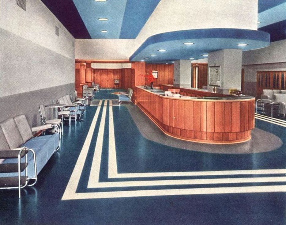
When he said that, though, I remembered an ad I had come across that I thought was pretty cool, simply because it shows the interior of one of the Centennial buildings when it was brand new (…well, it was sort of new — more on that below). The ad is for Armstrong Linoleum and it features a color photo showing one of their custom linoleum floors installed in the Centennial Administration Building, an interior I’d never seen. And it’s in color! (Check out the furniture and the recessed lighting!) Here’s the full ad, which appeared in national magazines in 1936 (click for larger image).
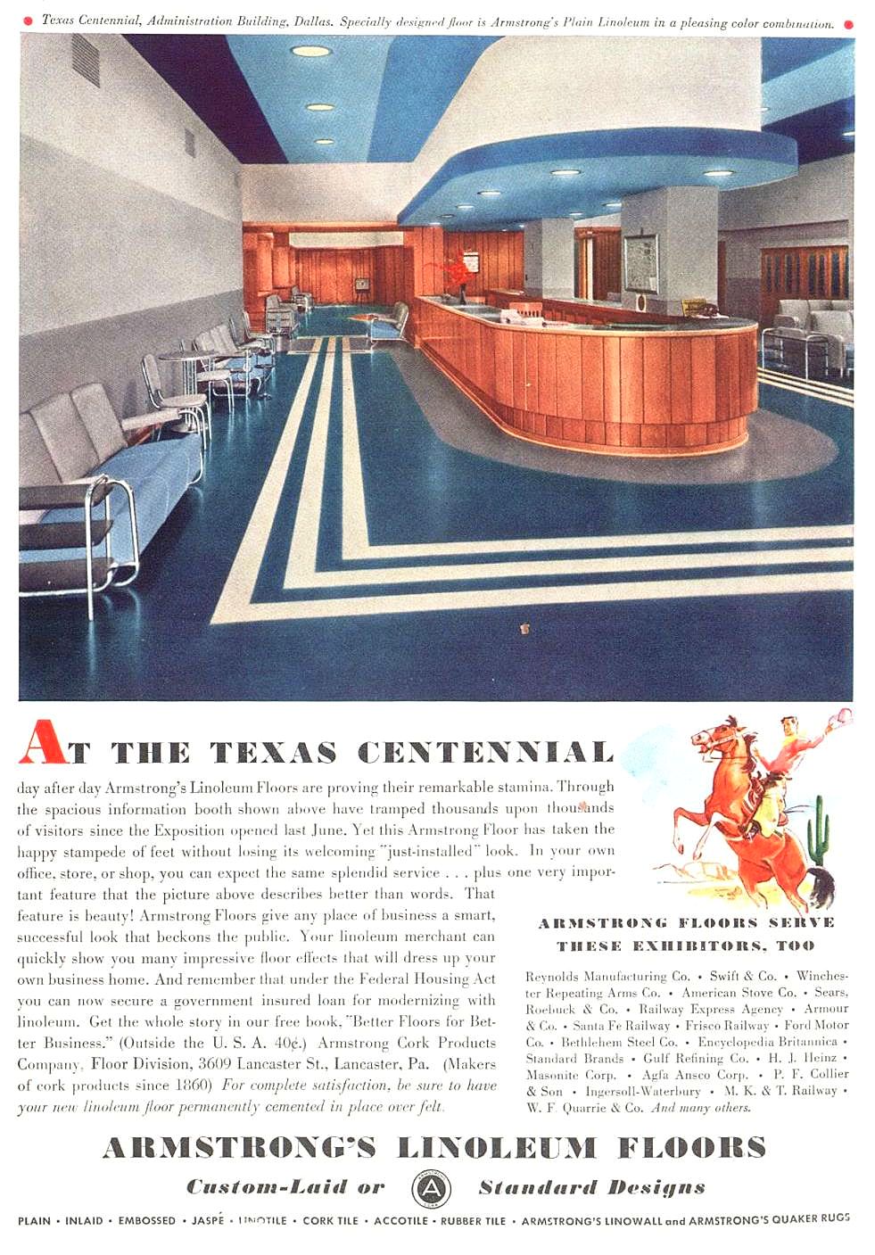
ad- tx-centennial_armstrong-linoleum_19361936 ad

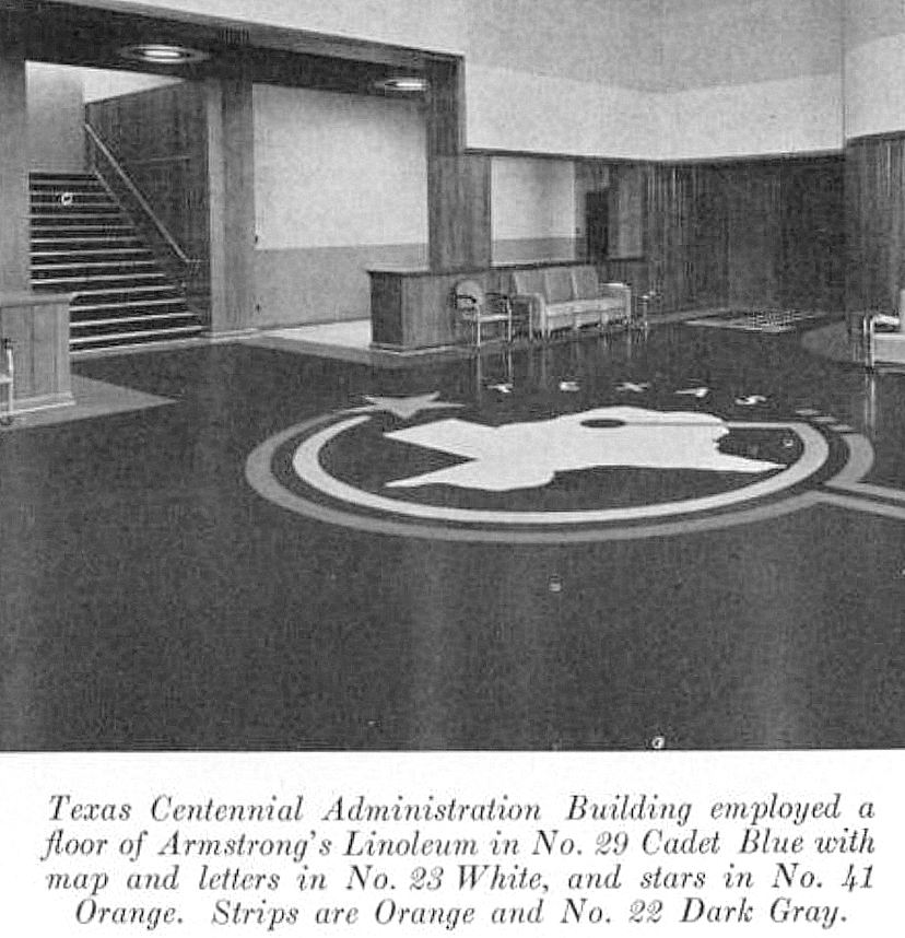
And — hallelujah — I found another photo of the interior — also from the helpful Armstrong people (I don’t know if they had the concession to outfit all the Centennial buildings, but, if so, I’d love to see all of their designs). Unfortunately this one is not in color, but it shows a fantastic Texas-centric custom design, laid down in fabulous linoleum.

tx-centennial_armstrong-linoleum_admin-bldg_texas-floor

And another one:

tx-centennial_administration-bldg-floor_southwest-business-mag_june-1936
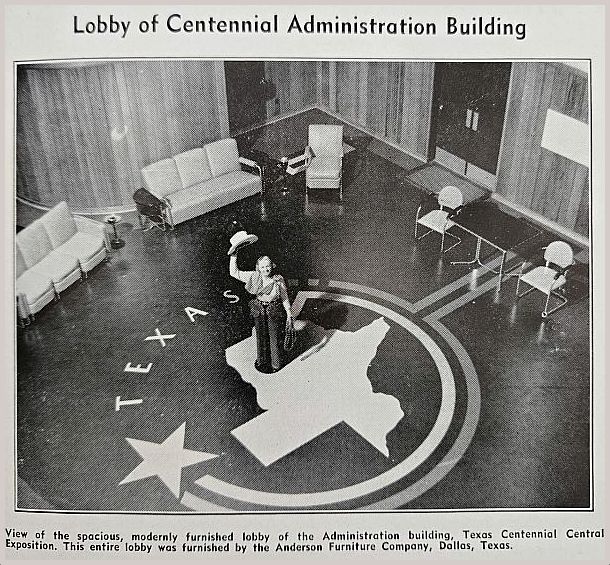
Southwest Business, June 1936

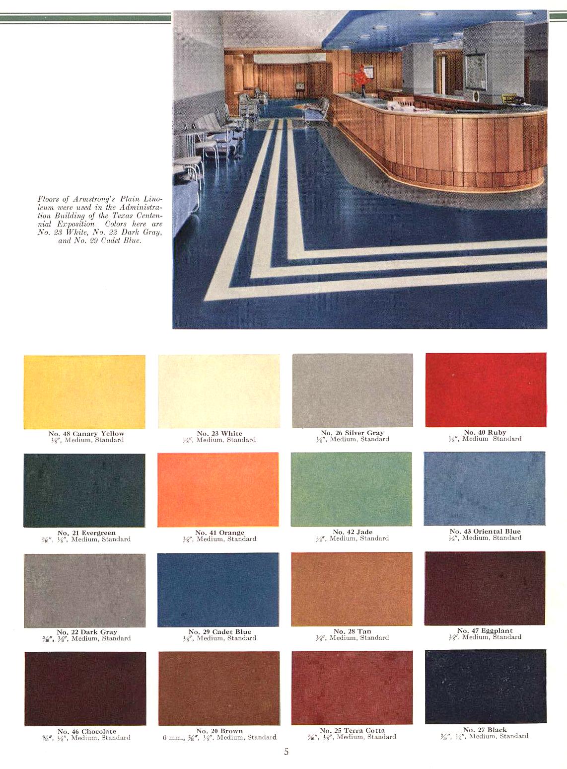
Imagine that floor in Cadet Blue, White, Orange, and Dark Gray. This is from a trade publication called Armstrong’s Floors and Walls for Homes and Public Buildings, published around 1950 (and fully scanned here). A cropped version of the photo of the top is also included here (that floor, by the way, is in White, Dark Gray, and Cadet Blue), with handy swatches (which, reproduced below, lose some accuracy in color).

tx-centennial_armstrong-linoleum_admin-bldg_colors

And just because I found an ad for those cool chairs:

tx-centennial_furniture_southwest-business-mag_oct-1936
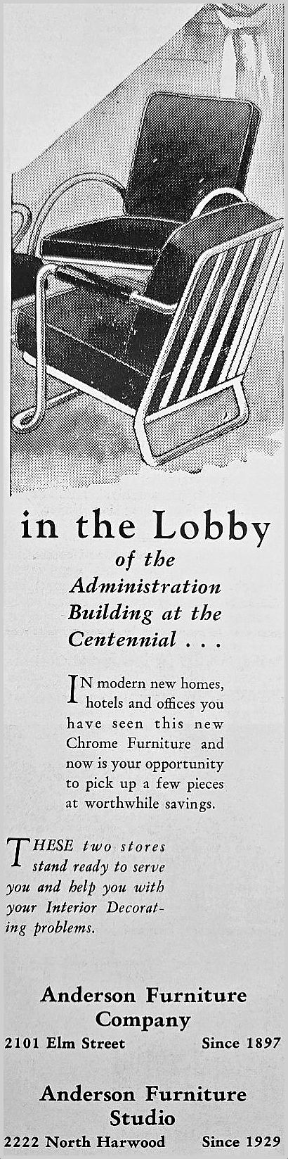
Southwest Business, Oct. 1936

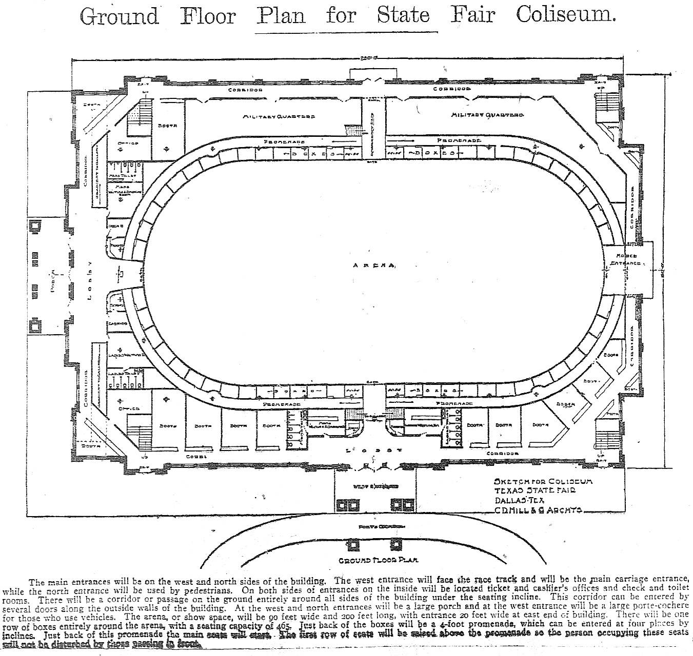
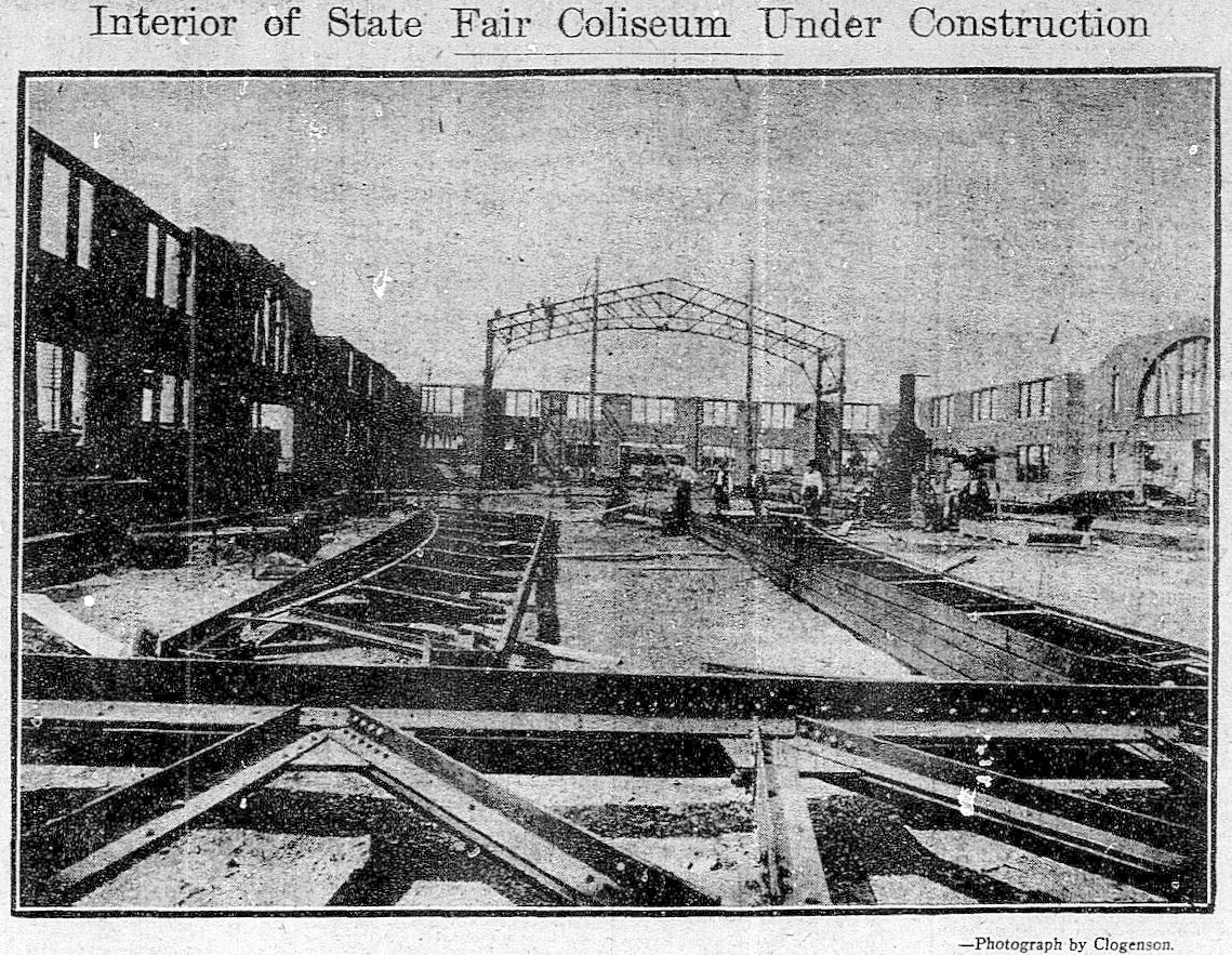
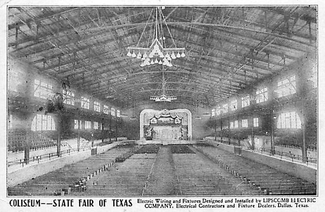
The Centennial Administration Building — which housed the hundreds of office workers and executives behind the running of the Texas Centennial Exposition — was actually the very first Centennial building completed (at the end of December 1935). Most of the Centennial buildings were newly built in 1936, but the Administration Building was actually an old building given a new stucco façade and completely remodeled — it even acquired a second floor inside the huge structure. This building was originally known as the State Fair Coliseum, built in 1910, designed by architect C. D. Hill (who designed many buildings in Dallas, including the still-standing Municipal Building downtown (built in 1914) and the Melrose Hotel (1924).

state-fair-coliseum_dmn_062009_drawingDallas Morning News, June 20, 1909

state-fair-coliseum_dmn_050710_constructionDMN, May 7, 1910

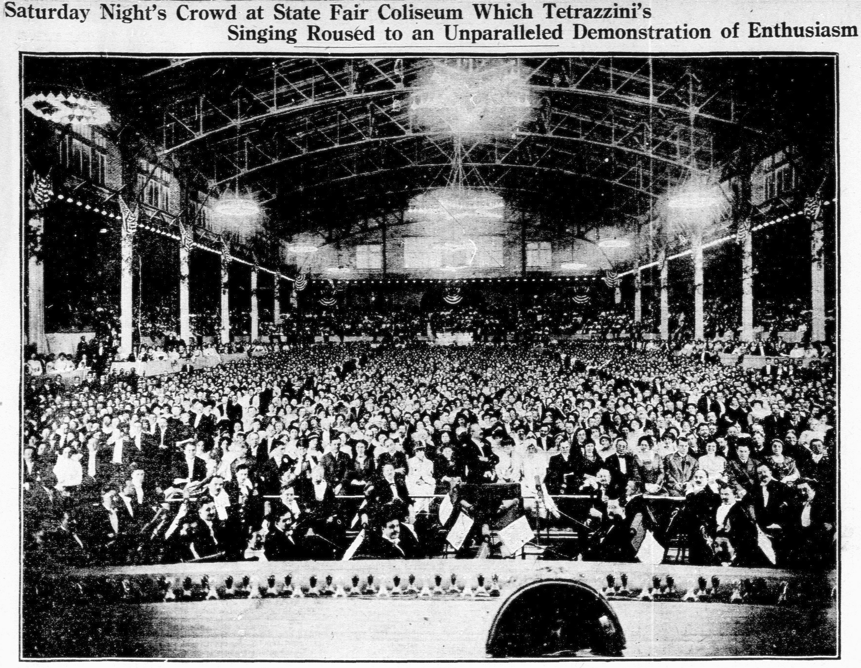
It was BIG. It had a seating capacity of 7,500.

state-fair-coliseum_flickr_coltera

state-fair-coliseum_dmn_030413DMN, March 4, 1913

This was the first building you’d see as you entered Fair Park, as it was right inside the front entrance on Parry Avenue (after you entered, the building would be on your left).

Coliseum Building, State Fair Dallas, TX

park-board-bk_fair-park-coliseum_1914

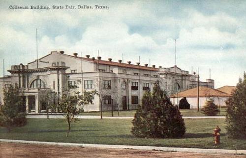
It was the city’s first official municipal auditorium, and it hosted everything from livestock shows, conventions, large civic gatherings, and the occasional opera.

Fast-forward a few decades: in 2000 the building became the home of the Women’s Museum. The museum closed in 2011 and is now called the Women’s Building and is used for special events.

A photo of the building from 2014:

womens-museum_fair-park_2014_carol-highsmith_library-of-congress
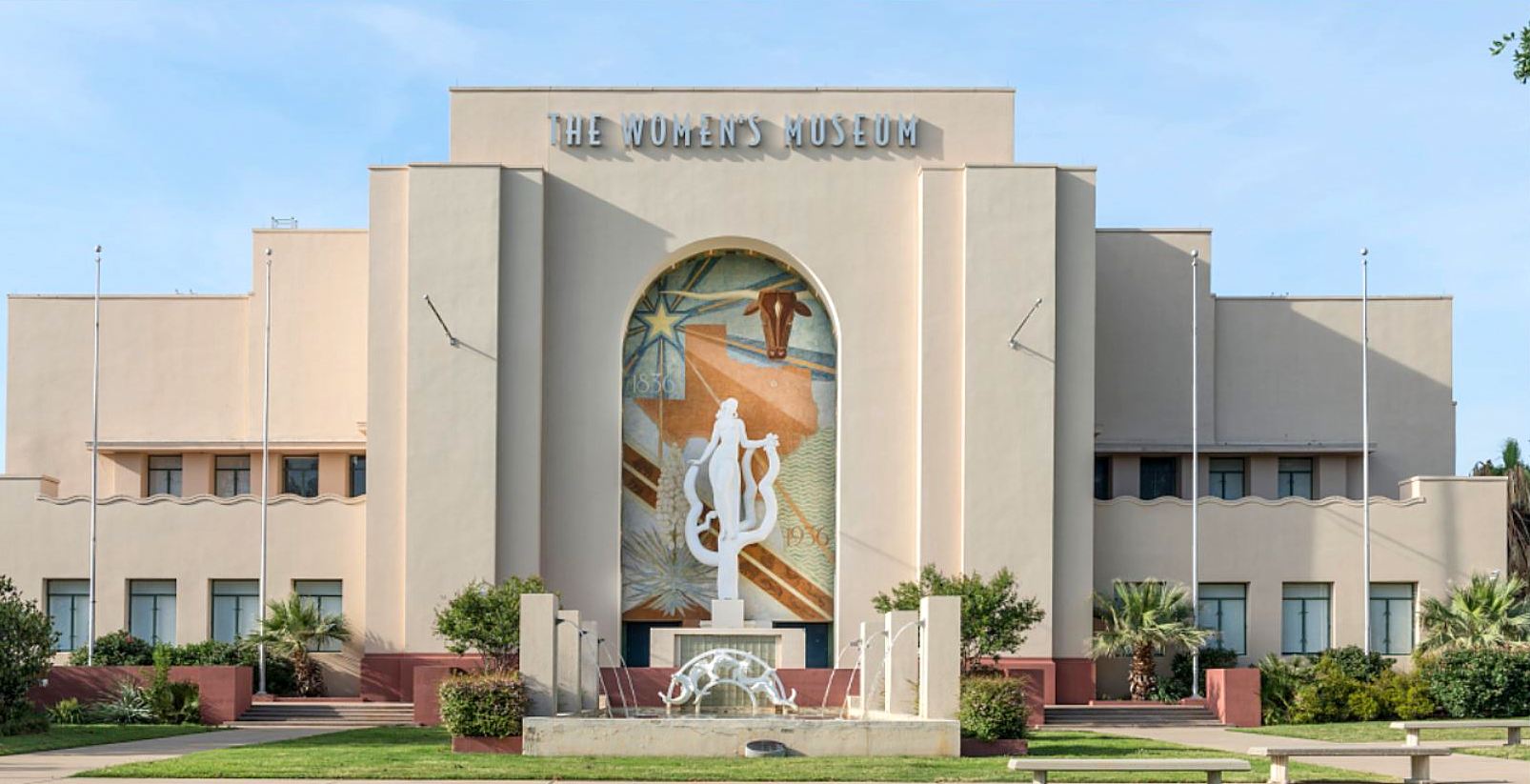
photo: Carol Highsmith, Library of Congress

See a Wikimedia photo of this building in 2016 here — click it again (and again) to see it really big, and linger on the mural by Carlo Ciampaglia and the sculpture by Raoul Josset. See interior photos of the space in 2009 during its time as the Women’s Museum here and here. I’m not sure if the exposed brick and steel are from the original 1910 building, but I certainly hope so! And, lastly, exterior photos from 2009 showing the side of the building here, and here

***

Sources & Notes

This building can be seen on this aerial Google view, here. It is currently the Women’s Building, and it is available for special events — more about this building from the Friends of Fair Park, here.

Black-and-white postcard showing the interior of the Coliseum is from Flickr.

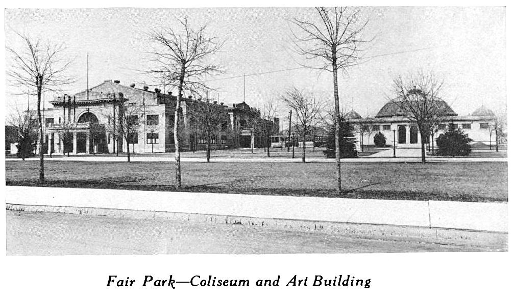
Black-and-white photo “Coliseum and Art Building” is from Report for the Year 1914-1915 of the Park Board of the City of Dallas, With a Sketch of the Park System (Dallas: Park Board, 1915), which can be accessed as part of the Dallas Municipal Archives via the Portal to Texas History, here.

And since this whole post was spurred by Jim Parsons’ talk the other night, here’s a link to the book he and David Bush wrote: Fair Park Deco: Art & Architecture of the Texas Centennial Exposition.

*

Copyright © 2018 Paula Bosse. All Rights Reserved.

Paving Matilda — 1971

milazzo_album_matilda_1971_3_120“Matilda gets a concrete face”… (click for larger image)

by Paula Bosse

A couple of days ago I wrote about the history of Matilda Street in regard to its role as a railway for the Sherman-Denison interurban and the Belmont streetcar line. I noted that I had childhood memories from the 1970s of Matilda being a dirt street — which seems hard to believe these days since it carries a fair amount of traffic and is generally a quicker drive than Greenville Avenue, one block west. 

In response, one of the many Milazzo siblings (whom I remember not as individuals but as one large flock of children who regularly accompanied their parents to visit my father’s bookstore in the 1970s and ’80s) sent me some photos from a family album showing, yes, Matilda Street being paved! They lived in the 5700 block of Goodwin, and the photos were taken in 1971, from their yard, looking east across Matilda.

The streetcar tracks were abandoned in 1955 but were not removed — it took a full sixteen years for them to be paved over! Before that? Dirt street. If you look closely at the Google Street View capture from Oct. 2017, you can see the old rails peeking through.

Below are three photos from the Milazzo’s family album showing the Matilda “street improvements.” The construction vehicle seen in the first two photos is pretty weird-looking — like a cross between a locomotive and a tank. In fact, at first I thought the thing was actually running on the rails it was working to pave over, until I saw that what I had thought were train wheels look more like tank treads. Whatever it is, it doesn’t look like something you’d expect to see on a residential street in the 1970s. In the third photo, you can see part of Robert E. Lee Elementary School at the left. (All photos are larger when clicked.)

matilda_milazzo_1971_a_120

matilda_milazzo_1971_b_120

matilda_milazzo_1971_c_120

Thank you, Milazzo family!

***

Sources & Notes

Photos from the collection of the Milazzo family, used with permission. The third photo shows a date-stamp of April, 1971.

The related Flashback Dallas post “Ghost Rails of the Belmont Streetcar Line” is here.

All photos are larger when clicked.

*

Copyright © 2018 Paula Bosse. All Rights Reserved.


Ghost Rails of the Belmont Streetcar Line

matilda-richmond_dan-parr-photo_FB-dallas-history-guild_april-2018Matilda & Richmond, April, 2018… (photo: Dan Parr)

by Paula Bosse

I grew up on Ellsworth, between Greenville Avenue and Matilda — just south of Mockingbird, just north of the M Streets. When I was a child, Matilda was only partially paved — in my neighborhood, maybe only from Mockingbird down to Kenwood? Otherwise, it was a dirt street (!) — and this was in the ’70s! Right around Kenwood was a weird mound which might not have looked like much to an adult, but to a child it was pretty strange. I can’t remember if the rails were visible — I’m pretty sure they were.

That line was the Belmont Line, which ended (began?) at Mockingbird (I think there was a later extension of sorts, but I think Mockingbird was the end of the line for streetcar passengers). As a kid, I knew that Matilda had been a long-gone streetcar line, but never having seen a streetcar outside of a movie, I couldn’t really imagine what it must have been like to have streetcars (and an interurban! — more on that below) moving up and down a street which was less than a block from my house.

A few years ago I stumbled across the YouTube video below and was surprised to see actual footage of that streetcar rolling up Matilda. The first five minutes of the video contains 16mm footage (both black-and-white and color) shot around Dallas in 1953 and 1954 by Gene Schmidt. It’s GREAT! You’ll see streetcars-galore moving past all sorts of familiar and vaguely familiar sights around the city, from Oak Cliff to downtown to way out to Mockingbird and Matilda. It ends with the Belmont-Seventh car (car 603) pulling to the end of the line — the view is looking south down an unpaved Matilda Street from Mockingbird, with a glimpse of the Stonewall Jackson playing field at the left, on the other side of the fence. (The Matilda footage begins at 4:17.)

*

belmont-line_matilda-from-mockingbird_youtube-cap_ca1954Matilda, south from Mockingbird, ca. 1954 (Gene Schmidt)

Above, a screen capture from the video showing Matilda looking south from just south of Mockingbird. Stonewall Jackson Elementary School is at the left. Today the view looks like this.

*

Before the streetcar arrived, Matilda was the artery that led the Texas Traction Company’s Sherman/Denison interurban into Dallas. This electric interurban service from the north, which closely followed the H&TC railroad line, arrived in Dallas in 1908, back when the official entry-point into the Dallas city limits was just off Matilda, near Greenville Avenue and Bryan Street.

1908_interurban_sherman-dallas_dmn_011608
DMN, Jan. 16, 1908 (click to read)

The interurban route connecting Sherman/Denison with Dallas opened on July 1, 1908 and lasted for 40 years, until its final run on December 31, 1948. (Read the Dallas Morning News article on the 1908 inaugural trip for big-wigs, “Many Make Trip Over Interurban,” July 1, 1908, here. Below is the accompanying photo. Image that running up and down Matilda — and, later, along other streets in Dallas — several times a day!)

interurban_sherman-dallas_dmn_070108
DMN, July 1, 1908

Dallas’ ever-increasing population began to move northward and eastward, necessitating public transportation which would connect these developing areas with the rest of the city. One of the early “suburban” lines was the Belmont Line, which branched off the Bryan Street line and served the Belmont Addition and beyond; it opened in 1913, but these early days appear to have been more of a private “dinky” service (see SMU’s dinky car on the beyond-the-city-limits tracks at Hillcrest and McFarlin, here). The Belmont line — as well as the Vickery Place and Mount Auburn lines — became part of the city’s official streetcar system in 1922.

Before the dinky service, riders were able to get on and off the large interurban cars at stops between Mockingbird and the area around Bryan and Greenville Ave. Even though interurbans and streetcars were able to travel on the same rails, it took years for dedicated streetcar tracks to be laid along Matilda.

This detail of a real estate ad shows that the Belmont line had reached at least as far as Richmond by 1914 (I felt I had to include this because the finger is pointing at the exact location of the exposed rails in the photo at the top!):

1914_matilda-richmond_lakewood-heights-ad_det_050314
May, 1914 (detail from Lakewood Heights real estate ad — see full ad here)

By 1922 the Belmont line had extended north to Velasco; by 1925 it had gotten to McCommas; by 1936 it had made it up to Penrose; and by 1939 it had finally reached Mockingbird (in time for the opening that year of Stonewall Jackson Elementary School, located at Mockingbird and Matilda).

Dallas streetcars began to be phased out in 1955, and the Belmont line was one of the first to go — its last run was March 6, 1955: “The Belmont-Seventh streetcar line will go out of existence Sunday to be replaced by service with new Diesel buses” (Dallas Morning News, March 6, 1955). The new bus route in the Lower Greenville area would, for the most part, be along Greenville Avenue, one block west of unpaved Matilda Street.

In March, 1955, it was reported that the abandoned Belmont-Seventh streetcar tracks were deeded to the city by the Dallas Railway and Terminal Co., with the understanding that they would eventually be paved over. The tracks were on Matilda, Bryan, Cantegral, Live Oak, St. Paul, King’s Highway, Edgefield, Seventh, Bishop, and Colorado. In April, 1956, it was reported that the City Council had approved the sale of the streetcar viaduct over the Trinity River and the Matilda street right-of-way.

But what about that paving of Matilda? Mrs. K. E. Slaughter had thoughts on the matter in a letter-to-the editor in April, 1955:

Since removal of the Belmont streetcar line in part — Matilda and Bryan streets — would it not be advantageous to develop this section into an important use to the heavy automobile traffic? Matilda now is no more than useless tracks built up between a cow path. (DMN, April 7, 1955)

“Cow path” — ha!

Another annoyed News reader wrote in 1963 — eight years after the tracks had been abandoned — about the useless unpaved thoroughfare:

The abandoned almost-private right of ways, such as Matilda, nearly two miles south from Mockingbird, received by the city in a deal to permit an all-bus operation, have not yet been paved or otherwise improved. (DMN, Oct. 21, 1963)

I’m not sure when that paving finally happened — early ’70s? — I think it must have been done in stages. I don’t remember a time when the stretch between Mockingbird and Kenwood wasn’t paved, but I do remember Matilda being a dirt road south of Kenwood. I don’t have a good recollection of the year, but kids remember all sorts of weird things, and those mysterious mounds were pretty memorable. (UPDATE: See photos of Matilda being paved at Goodwin in 1971 here.) I wish I’d known what an interurban was when I was a child. That would have made my neighborhood seem a whole lot more interesting! Heck, it used to the Gateway to Sherman!

I’ve long despaired of having missed the streetcar age. But it’s nice to know that one ran so close to the house I grew up in.

belmont-line_matilda-mockingbird_youtube-cap_ca1954End of the line, ca. 1954… (Gene Schmidt)

belmont-car_lakewood-heights-ad-det_050314

***

Sources & Notes

Top photo taken by Dan Parr on April 15, 2018; it was originally posted to the Facebook group Dallas History Guild and is used here with permission. (Thanks, Dan!) The photo was taken at Matilda and Richmond, looking south on Matilda. See it on Google Street View, here. (Roadwork along Matilda is awful at the moment, but much-needed. Apparently it is being reduced to three lanes for automobiles with two bike lanes being added — read about it in the Lakewood Advocate, here.)

YouTube video shot by Gene Schmidt in 1953 and 1954; the direct link is here.

Another interesting video on YouTube was made by the City of Allen and contains period footage of the interurban that served North Texas. It’s a breezy 6-and-a-half  minutes, and it includes some cool shots of Dallas.

If you want to see a whole bunch of North Texas interurban photos, check out this great 83-page PDF compiled by DART, “History of the Interurban Railway System and Monroe Shops,” here.

Speaking of DART, they posted a cool 1925 map of streetcar and interurban lines, here — click the map to see a larger image. (In 1925, the Belmont line ended on Matilda at McCommas).

ALSO extremely cool is a Google map showing Dallas’ Historical Streetcar (and Interurban) Lines laid over a present-day Google map, here. Zoom in and out. Very useful!

streetcar_belmont_color_ebayeBay

belmont-streetcar_new-moon_1940_palace_ebay1940, eBay

belmont-streetcar_1954_ebay1954, eBay

*

Copyright © 2018 Paula Bosse. All Rights Reserved.

Casa Magnetica

six-flags_casa-magnetica_postcard_flickrHow often is juggling mind-blowing? It was here! (click for larger image)

by Paula Bosse

Every year my aunt and her fun friend Shirley took my brother and me to Six Flags Over Texas. This was the ’70s, so some of the original hard-to-believe attractions were already gone (helicopter and stagecoach rides?! — see a promotional video of the park from 1965 here), but it was still when the place was an actual “theme” park — an amusement park originally suggested by aspects of Texas history. The sections of the park represented the six flags that have flown over Texas (see a map here). One of those sections was the Spanish section, the location of two of my favorite Six Flags attractions: the log ride and Casa Magnetica.

Casa Magnetica was the hard-to-wrap-your-brain-around tilted house (newspaper articles reported it was built at either a 24.6-degree angle or a 34-degree angle) which made you feel completely disoriented, especially if you’d just stepped in from the blinding blast of 110-degree heat and were feeling a bit queasy from one too many Pink Things. I loved it. Things rolled uphill, you couldn’t stand up straight, and your brain was mighty confused. The text from the back of the postcard seen above:

six-flags_casa-magnetica_postcard_back

Casa Magnetica was introduced very early in Six Flags’ history — it debuted in the second season, 1962, and it was a huge hit. Here is how the SFOT marketing team described it in press releases at the time. (Clippings and images are larger when clicked.) Imagine what it would have been like to have been the architect of this place!

six-flags_casa-magnetica_daily-news-texan_042262Six Flags Gazette, April 22, 1962

six-flags_casa-magnetica_daily-news-texan_042962_text
Six Flags Gazette, April 29, 1962

As far as new attractions, the weird little house was the biggest hit of the 1962 season.

six-flags_casa-magnetica_daily-news-texan_042063
Six Flags Gazette, April 20, 1963

Here it is, under construction, in late 1961 or early 1962:

casa-magnetica_under-construction_history-of-six-flags-FB-group

And, later, with a teenage “hostess” sitting under its Spanish-mission-inspired arch.

casa-magnetica_six-flags-FB-page

*

six-flags_casa-magnetica_daily-news-texan_052762

The caption of the photo above: “WHICH ONE’S STRAIGHT? — It’s hard to tell in the Casa Magnetica in the Spanish section. It’s difficult to keep from leaning the wrong way in this house where water seems to run uphill. Notice in the lower left of the picture how the basketful of goodies seems to be hanging instead of sitting.” (Six Flags Gazette, May 27, 1962)

*

six-flags_casa-magnetica_daily-news-texan_042962

Caption: “SOMETHING WRONG? — Six Flags hostesses find that the law of gravity doesn’t seem to apply in Casa Magnetica.” (Six Flags Gazette, April 29, 1962)

*

six-flags_casa-magnetica_irving-daily-news-texan_04262

Caption: “LEMME OUT! — In Casa Magnetica, a house in the Spanish Section of Six Flags which defies gravity, this hostess gets a little panicky when the 34-degree slant proves too much for her.” (Six Flags Gazette, April 26, 1962)

***

Sources & Notes

Postcard at top from Flickr.

Articles and captioned photos are from the Six Flags Gazette, a seasonal supplement that appeared in both the Grand Prairie Daily News-Texan and the Irving Daily News-Texan during the early years of Six Flags.

Photo of Casa Magnetica under construction in the scrubby Arlington landscape is from the History of Six Flags Facebook group, posted there by the administrator Michael Hicks, submitted to Flashback Dallas by reader Brian Gunn (thank you, Brian!).

The photo of the Six Flags “hostess” sitting outside the entrance to Casa Magnetica is from the Six Flags Over Texas Facebook page, here (it appears with a photo of the Chaparral Antique Cars, the second-most popular attraction introduced in the 1962 season).

Read the “spiel” you’d hear when you visited Casa Magnetica, here.

And, in case you missed it above, I highly encourage you to watch the 6-minute Six Flags Over Texas promotional film from 1965 at the Texas Archive of the Moving Image (TAMI) website here (Casa Magnetica is seen briefly at the :45 mark). Watch it full-screen!

More Flashback Dallas posts on Six Flags Over Texas can be found here.

*

Copyright © 2018 Paula Bosse. All Rights Reserved.


The L. P. Sigler Jewelry Store, Peak & Elm

peak-and-elm_cook-collection_degolyer_SMUNorth Peak & Elm, southeast corner… (click for larger image)

by Paula Bosse

Dr. Lough Phillip Sigler (1884-1951) was an optometrist who moved to Dallas from Denton County in 1908; the following year he opened a jewelry and watch store inside an Old East Dallas pharmacy at 4301 Elm Street, at the northeast corner of Elm and North Peak, eventually expanding into the adjoining storefront. In 1930 he moved across the street into a brand new building at the southeast corner of Peak and Elm: 132 N. Peak, seen in the photo above.

This type of neighborhood retail strip of shops and cafes was a common site throughout the city, and there are several still standing, most of which I’ve seen in Old East Dallas and Oak Cliff. I love these strips, and, thankfully, the one seen in the photo still stands.

peak-and-elm_googleGoogle Street View, 2016

The jewelry company founded by Dr. Sigler had an amazingly long life: the store opened at Peak and Elm in about 1910 (at the northeast corner) and remained in business (at the southeast corner) until well into the 1970s. The business which currently stands at 132 N. Peak is a very charming Mexican restaurant called Peak & Elm Cocina y Bar (check it out!).

***

Sources & Notes

Top image — “Peak & Elm Sts.” — is from a real photo postcard in the George W. Cook Dallas/Texas Image collection, DeGolyer Library, Central University Libraries, Southern Methodist University; more information on this photo can be found here.

If I had to guess the date of the image, I’d guess around 1930 when Sigler moved into the new location. The strip appears to have been built in 1929, with its first tenants showing up in the 1930 city directory. See it today on Google Street View, here.

Just as an interesting historical note, directly across Peak from Sigler’s jewelry store were car barns and machine shops for some of the city’s electric railway streetcars — they can be seen in a 1922 Sanborn map here. Those blocks are currently occupied by Dallas Area Rapid Transit facilities.

The 1922 map showing blocks occupied by Mr. Sigler’s store(s) is here (his first location at 4301-03 Elm is seen, but the building which housed his later store at 132 N. Peak is not seen as it would not be built for another seven or eight years). 

*

Copyright © 2018 Paula Bosse. All Rights Reserved.


The Prelude to the Great Flood of 1908

commerce-st-bridge_1908_cook-degolyerApril 20, 1908… (click for larger image) / SMU

by Paula Bosse

The greatest flood Dallas has ever known — the disastrous flood of 1908 (read about it here) — happened in the spring of 1908. The Trinity River reached its highest crest of more than 52 feet on May 26. The photo above was taken on April 20 — five weeks before that.

On April 20, 1908 — the day this photo was taken — The Dallas Morning News reported that after three weeks of rain the Trinity had finally crested at “nearly 39 feet.” This flooding was the worst in 20 years and the third worst on record.

In a mere five weeks, though, every record regarding the Trinity River and flooding in Dallas would be broken. Those people who had ventured out to survey the river from the Commerce Street Bridge that April day had no idea what was in store for them in just 35 days.

Let’s zoom in on this photo and look at some of the details of the crowd and the bridge (all images are larger when clicked).

commerce-st-bridge_1908_cook-degolyer-det1

commerce-st-bridge_1908_cook-degolyer-det2

commerce-st-bridge_1908_cook-degolyer-det3

Above: are refreshments being sold?

commerce-st-bridge_1908_cook-degolyer-det4

commerce-st-bridge_1908_cook-degolyer-det5

commerce-st-bridge_1908_cook-degolyer-det6

commerce-st-bridge_1908_cook-degolyer-det7

“NOTICE: $25.00 FINE FOR DRIVING FASTER THAN A WALK ACROSS THIS BRIDGE.”

commerce-st-bridge_1908_cook-degolyer-det8

**

The editorial cartoon below appeared on the front page of The Fort Worth Telegram next to a story with the headline “Dallasites Flee Flooded Homes; River is Rising.”

flood_FWST_042008_help-them
FWT, April 20, 1908

In May, this photo (by Henry Clogenson) showing “Highest Water in the History of Dallas” appeared in The Dallas Morning News:

flood_dmn_052608_clogenson_commerce-st-bridge
DMN, May 26, 1908

Another photo by Clogenson:

trinity-river_flood_1908_LOC-lg

For comparison, here’s the bridge at a calmer time:

commerce-street-bridge_legacies_fall-1995

Flood memorabilia? Check out the book and stationery department at Sanger Bros.

flood_postcard-sales_dmn_060408_sangers-ad-detJune, 1908

***

Sources & Notes

Top photo titled “Commerce St. Bridge, Trinity River, Dallas, Tex., April 20, 1908” from the George W. Cook Dallas/Texas Image Collection, DeGolyer Library, Central University Libraries, Southern Methodist University; the photo and more information can be accessed here.

The wide-angle photo of the Commerce Street Bridge, taken by Henry Clogenson, is from the Library of Congress, here.

“Calmer” photo of the Commerce Street Bridge is from the Fall, 1995 issue of Legacies, from the article “Bridges Over the Trinity” by Mary Ellen Holt.

Read the Dallas Morning News article “Trinity Flood Crest Has Reached Dallas … Great Damage is Reported” (DMN, April 20, 1908) here.

*

Copyright © 2018 Paula Bosse. All Rights Reserved.

Forest Avenue-Area Flooding, South Dallas — 1935

flooding_forest-avenue_lloyd-long_052035_ebayBeyond the levees… (click for larger image)

by Paula Bosse

Sometimes the Trinity River is a puny little trickle, sometimes it’s a raging torrent. Here are aerial photos taken from around Forest Avenue (now MLK Blvd.) by Lloyd M. Long, showing the major flooding of May, 1935.

Here is the lead sentence from The Dallas Morning News, May 21, 1935 (the day after these photos were taken):

With sections of South Dallas inundated for the first time since the record 1908 flood, numerous bridges and highways and thousands of acres of lowlands hidden by its swirling, muddy currents, the roaring Trinity slowly was receding Monday night at Dallas after reaching a crest of 42.10 feet at 11 a.m. (DMN, May 21, 1935)

flooding-levee-district-from-forest-ave_lloyd-long_052035_ebay

There was great rejoicing that that the new-ish levees had held the waters and prevented the wide-scale flooding seen in 1922. But once you got to the Forest Avenue bridge (which ran below the Corinth St. viaduct and the Santa Fe railroad trestle), things got real bad real fast. In the photo above, the levee protection ends exactly at the railroad trestle — the Forest Avenue bridge is mostly underwater. The river above the trestle: a beautiful feat of engineering; below: water, water everywhere.

Below the Forest Ave. bridge where the levee protection ended, flood conditions were far worse than those created by the 1922 inundation. (DMN, May 21, 1935)

Again, sometimes the Trinity is just a trickle….

***

Sources & Notes

Both photos (by Lloyd M. Long) are from 2017 eBay auctions: the top photo here, and the bottom photo here.

More on Dallas flooding can be found in these Flashback Dallas posts:

  • “The Nellie Maurine: When a Pleasure Boat Became a Rescue Craft During the Great Trinity River Flood of 1908,” here
  • “One of the Victims of the Great Trinity Flood: The T & P Railroad Trestle — 1908,” here
  • “The Trinity River at the City’s Doorstep,” here
  • “Cole Park Storm Water Detention Vault,” here

Maybe it’s just me, but I was really taken with that little L-shaped building in the top photo which was, briefly, its own island. What was it? It was part of the Guiberson Oil Well Specialty Corporation, founded in 1919 at 1000 Forest Avenue — the building seen in the photo was built in 1926. It’s still standing (here) and appears to be part of Faubion & Associates, a manufacturer of retail display cases and store fixtures.

Click photos to see larger images.

*

Copyright © 2018 Paula Bosse. All Rights Reserved.

900 Block of Main, North Side — 1952

AR447-B1201Main Street, 1952… (Squire Haskins Collection, UTA)

by Paula Bosse

This 1952 photo by Squire Haskins shows the north side of Main Street, taken at the intersection with Poydras, looking west to the old Dallas County jail and criminal courts building seen at the far left. The Sanger’s building stands just west of Lamar, and across Lamar is the 900 block of Main, with the legendary E. M. Kahn men’s clothing store (one of Dallas’ first important retail stores, founded in 1872), the Maurice Hotel (in the old North Texas Building, built in 1888/1889), and the large Bogan’s grocery store at the northwest corner of Main and Poydras. The old jail and the Records Building (way in the distance) and the Sanger’s building are all that remain. See how this view looks today, here.

There is a flyer for “Porgy and Bess” on the lamppost in front of the Bogan market. “Porgy and Bess” opened the State Fair Summer Musicals series at the State Fair Auditorium (Music Hall) in June, 1952 (see an ad here).

But what about the south side of the 900 block of Main Street? Thankfully, photographer Squire Haskins  not only took the photo above, he also turned to face the other side of the street and snapped companion photos. I posted two of his photos of the south side of Main in a previous post, here. Here’s one of those photos, with Poydras at the left and Lamar on the right:

main-poydras_squire-haskins_uta

A listing of the businesses from the 1953 city directory — there’s a little bit of everything (click to see larger image):

900-block-main_1953-directory

***

Sources & Notes

Both photos by Squire Haskins, both from the Squire Haskins Photography, Inc. Collection, University of Texas at Arlington. More info on the top photo can be found here; more on the second photo, here.

More on the south side of Main Street can be found in the Flashback Dallas post “900 Block of Main Street, South Side — 1950s,” here.

All images larger when clicked.

*

Copyright © 2018 Paula Bosse. All Rights Reserved.

McKinney & Haskell, Circle “T” Frozen Foods, and VWs in Dallas

mckinney-and-haskell_NDHS_ebayFender-bender in front of NDHS… (click for larger image)

by Paula Bosse

Odd stuff shows up on eBay. This photo shows a damaged Circle T Brand frozen-food Volkswagen delivery van at the intersection of McKinney Avenue and North Haskell (with North Dallas High School making a partial cameo in the background). The view today? See it here.

Circle T was one of the many brainchilds of the Southland Corp.’s Thompson family: it manufactured and distributed frozen foods (initially meats and Mexican food) which were sold in the company’s 7-Eleven stores. The company began in 1954 and was located just a couple of blocks from this photo, at Haskell and Central. (In 1954 they announced one of their first specialty products: frozen queso. I’ve never even considered that frozen queso would exist, but 60-some-odd years ago it was flying off shelves at the neighborhood 7-Eleven.)

The Southland Corp. sold off Circle T in 1966.

Below, an ad for Circle T’s frozen steaks, from 1954 (click ad to see larger image).

cicle-t_FWST_062054June, 1954

circle-t-logo_1954

And because I’m nothing if not pedantic, here’s an ad for VW trucks and vans, from 1961 (which appears to be the date on the van’s license plate in the photo):

volkswagen_ad_fen-1961Feb., 1961

And speaking of Volkswagens, the first Dallas car dealer to import Volkswagens appears to be Clarence Talley — the first ads are from 1954. While I was searching for the link to the eBay listing of the above photo (which I could not find…), I serendipitously stumbled across this 1950s photo of Clarence Talley on N. Pearl, with appearances by the Medical Arts Building and the Republic Bank Building. Thank you, eBay.

talley-volkswagen_ebay

***

Sources & Notes

Photos from eBay: could not find the link to the first one, but the second one sold a couple of months ago, and the archived listing is here.

*

Copyright © 2018 Paula Bosse. All Rights Reserved.

The Magnolia Cafe, N. Lamar & Munger — 1947

magolia-cafe_1947_ebayStep in for a cool glass of Metzger’s Milk…

by Paula Bosse

I love stumbling across photos of random small businesses. This photo from 1947 shows an interesting modification of a rooming house in the area immediately north of downtown at 1914 N. Lamar, at the corner of what is now N. Lamar and Munger (the curb shows “Caruth St.,” the street’s original name). Unsurprisingly, this former residential area — which became an industrial warehouse district — looks pretty different today (see the current Google Street View here). A succession of cafes operated here over the years (while people lived in rented rooms upstairs) since at least 1927.

I love the entrance to the rooming house with the concrete steps to the right of the cafe, the street light, the streetcar tracks, The Metzger’s Milk sign, the Stier’s Laundry truck, the parked cars, and the street names (probably in tile?) on the curbs.

Three years after this photo was taken, the building was up for sale:

magnolia-cafe_nov-1950_bldg-for-sale1950

Its future? A parking lot.

A longtime owner of this combo building was Mrs. Ella Mae Stuart, who was living there with her husband as early as 1913 (possibly 1909). After her husband’s death in 1915, she ran a boarding house upstairs and rented out the cafe below. She seems to have been a much-married woman who was very creative with her age as given to census takers: every 10 years she continued to grow younger and younger, ending up in 1930 with her age listed as 50. She died three years later at the actual age of 68, leaving behind a husband 26 years her junior. Her great stamina might be the result of her regular consumption of a wonder tonic called Konjola (a patent medicine popular during Prohibition, made from roots, herbs, and a lot of alcohol). (Click to read Mrs. Stuart’s testimonial.)

e-m-stuart_konjola-ad_1930
1930

***

Sources & Notes

Photo from eBay; taken by Rogers Studio (the business owned by noted Dallas photographer Frank Rogers and his son Norman Rogers), with the date “May 8, 1947” stamped on the back. Also on the back of the photo: “Magnolia Cafe, Lamar and Munger; seating capacity: 32.”

See the building on the 1921 Sanborn map here, which shows 1914 N. Lamar at the corner of Caruth Street. It appears the house might have become renovated to include a cafe on the ground floor in 1926 or 1927 when one of Mrs. Stuart’s boarding-house roomers opened up Frank’s Lunch Room.

*

Copyright © 2018 Paula Bosse. All Rights Reserved.