Flashback : Dallas

A Miscellany: History, Ads, Pop Culture

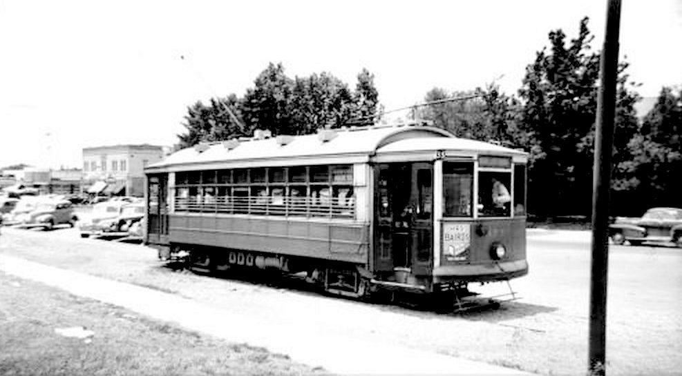
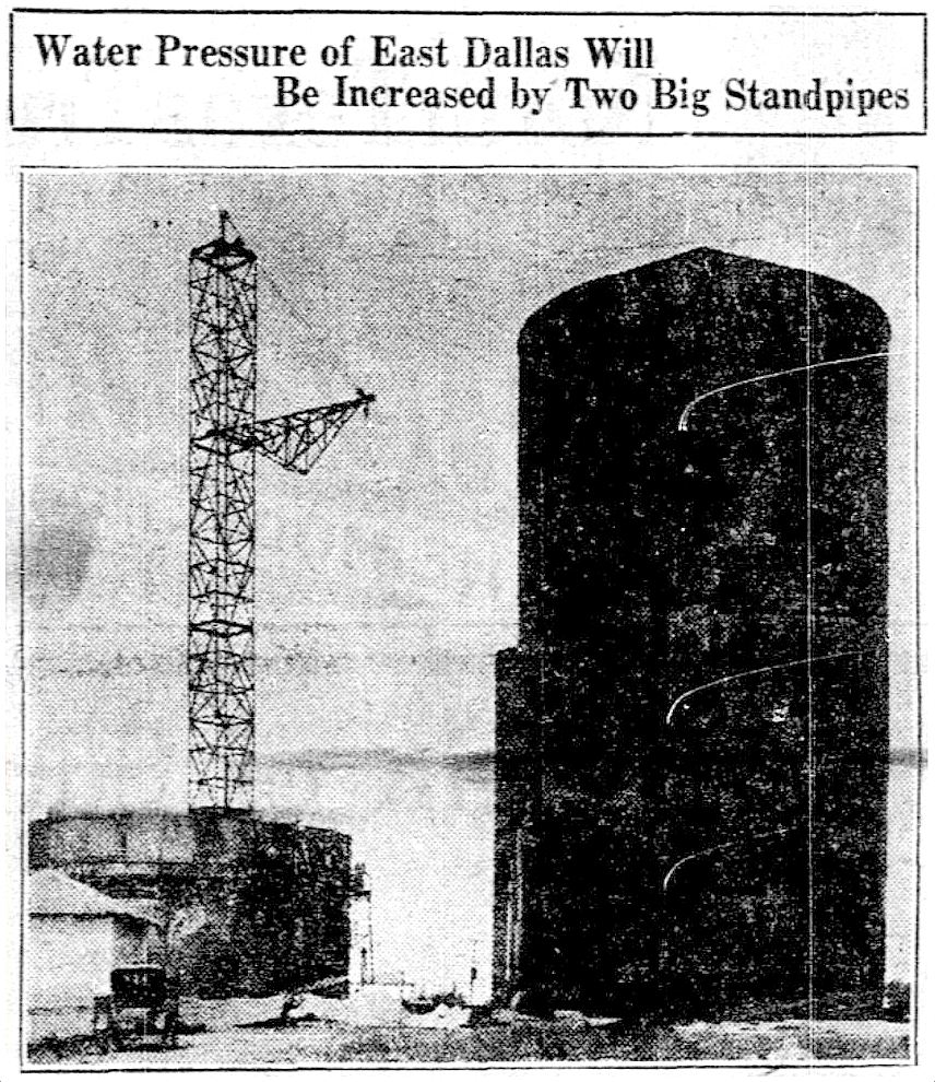
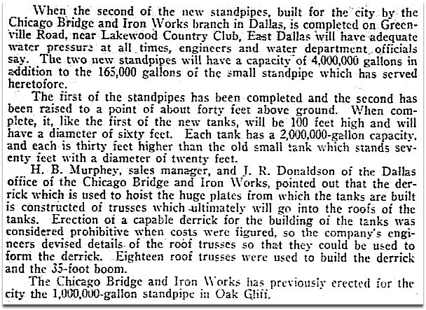
Pacific Avenue: Watch for Trains! — ca. 1917

pacific-akard_park-cities-photohistory_frank-rogersToo close for comfort…

by Paula Bosse

Some people don’t realize that Pacific Avenue used to be lined with the railroad tracks of the Texas & Pacific Railway (hence the name “Pacific”). When trains weren’t barreling down Pacific regularly, the thoroughfare was used by non-locomotive traffic like pedestrians, bicycles, horses, and automobiles. When a huge cinder-spewing train screamed through, everything came to a resigned halt until it passed by. I can’t even imagine what that was like. I wonder how many times people, horses, vehicles, etc. didn’t manage to get out of the way in time?

When Union Station opened in 1916, trains that had previously run through the central business district now went around it (which probably cut the number of people rushed to the hospital with train-related injuries substantially).

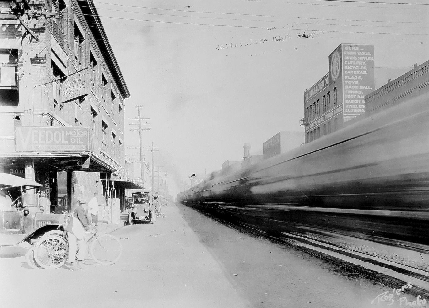
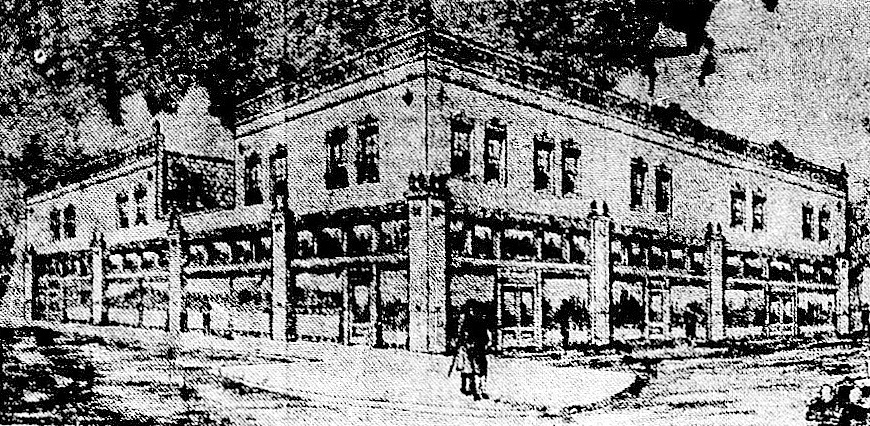
The photo above shows Pacific looking east from N. Akard, as a blur of a train whooshes by. The Independent Auto Supply Co. (300 N. Akard) is at the left, and, at the right, the back side of Elm Street businesses, including Cullum & Boren and, to its left, the Jefferson Theater, with “Pantages” painted on the side. (The Jefferson was the Dallas home of the Pantages Vaudeville Circuit from 1917 until 1920, the year the Pantages people bugged out for the greener pastures of the Hippodrome, leaving the Jefferson to start a new relationship with the Loew’s circuit people. At the end of 1925, the Jefferson Theater was actually renamed the Pantages Theater. …Kind of confusing.)

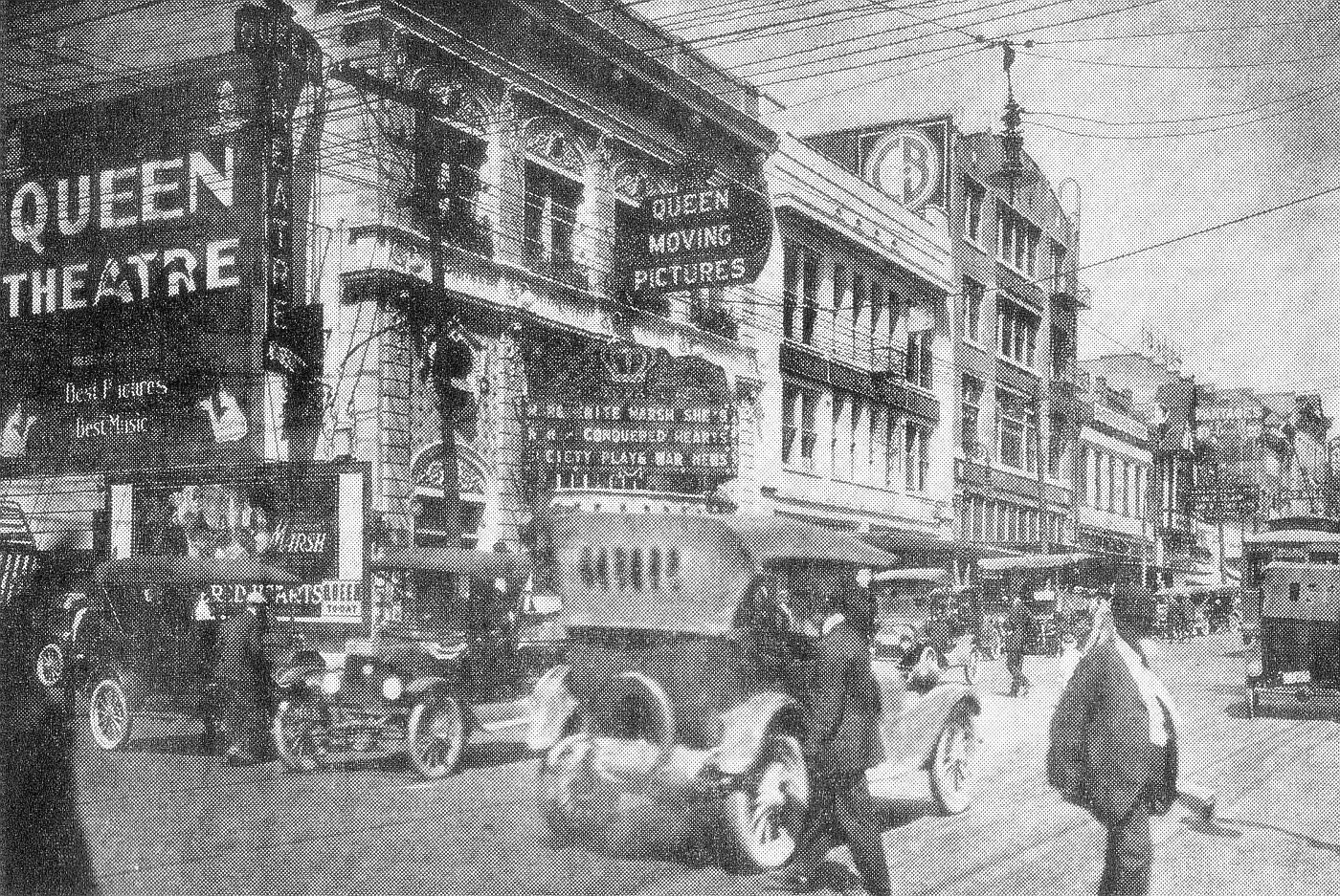
Below, Elm Street in 1918 — what the other side of those buildings looked like. Cullum & Boren’s “CB” logo can be seen painted on the side of its building. (Click photo for much larger image.)

dallas-movie-palaces_1918_dth_020556

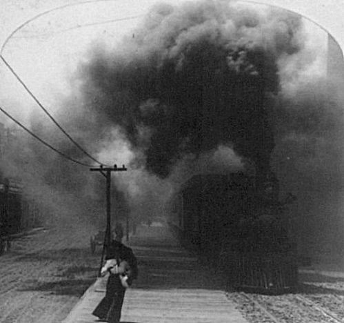
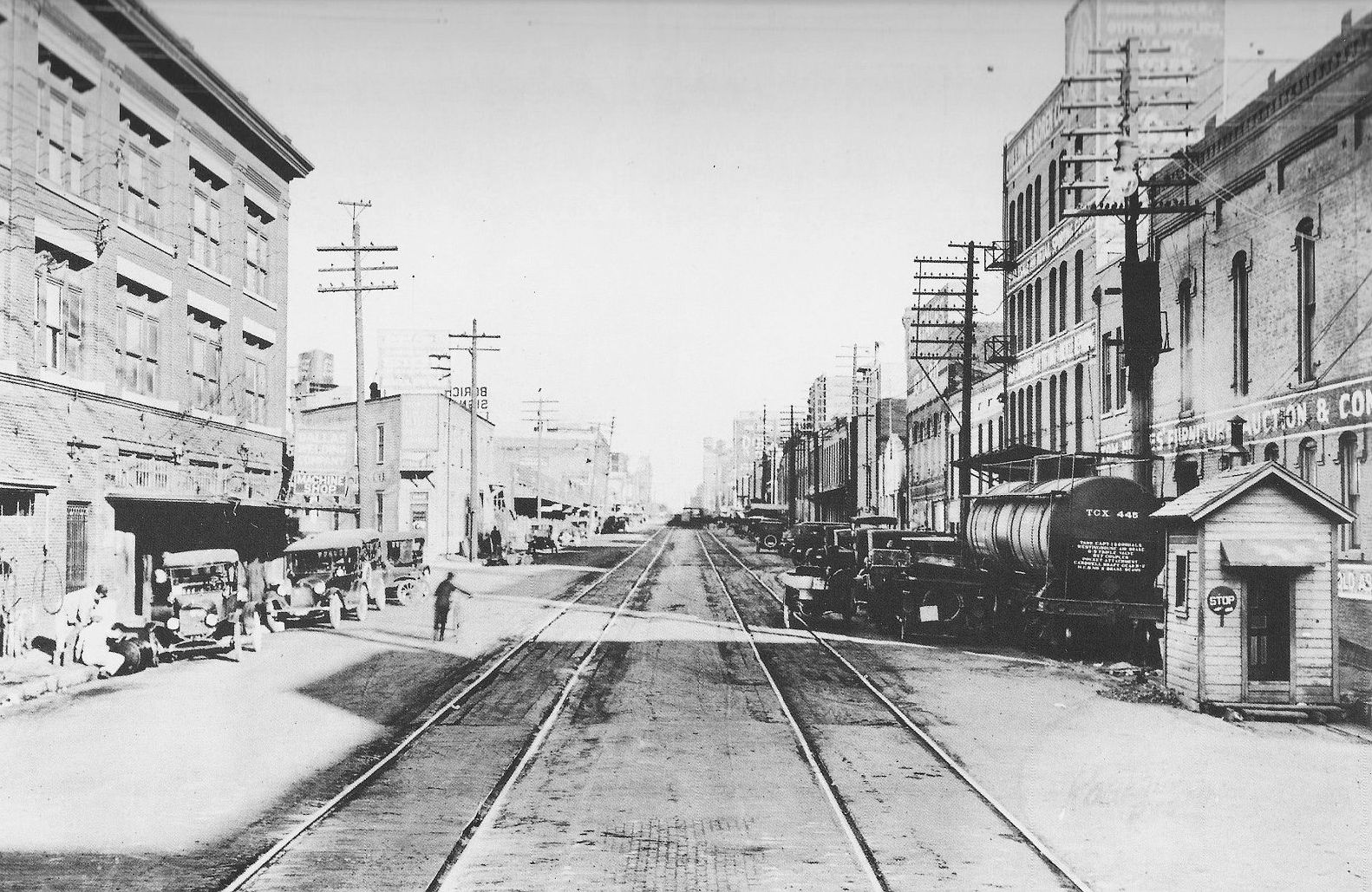
But back to Pacific in its scary, sooty, T&P-right-of-way days. This is what things looked like in 1909.

t-and-p-flier_1909_loc

Fast-forward to 1920 — the trains had long stopped running, but the tracks remained, an eyesore and an impediment to traffic. (Cullum & Boren, again, at the right.)

pacific-ave_showing-t-and-p-tracks_1920

And another one.

pacific_ave_ca-1920_legacies_fall-1990

Thanks to the Kessler Plan, those unsightly tracks were finally removed from Pacific in 1923. Below, a photo from 1925. Big difference. Thanks, George Kessler!

pacific_bryan_looking-east_lost-dallas_doty

***

Sources & Notes

Top photo (by Frank Rogers) from the book The Park Cities, A Photohistory by Diane Galloway (Dallas: Diane Galloway, 1989). The photo is credited to John Stull/R. L. Goodson, Jr., Inc./Consulting Engineers.

More info on the 1918 photo of Elm Street, which was featured in the post “Dallas’ Film Row — 1918,” here.

More info on the super-sooty Pacific Avenue photo, here.

More on the de-track-ified Pacific, here.

Not sure of the source of the first 1920 photo; the second 1920 photo is from Legacies, Fall 1990, here.

*

Copyright © 2016 Paula Bosse. All Rights Reserved.


University Park’s “Couch Building” Goes Up In Flames (1929-2016)

goffs_fire_dmn-081216_ashley-landis-photo
Photo: Ashley Landis/DMN (click for huge image)

by Paula Bosse

Yesterday, fire erupted in the old University Park building at the northwest corner of Hillcrest and McFarlin. The building — which housed Goff’s Hamburgers and several other businesses — is, today, a pile of rubble. I’ve always loved this building — every time I’d drive past it I’d smile, happy that the only truly distinctive non-SMU building along that part of Hillcrest was still standing. And now it isn’t.

The building — which was built in 1929 across Hillcrest from McFarlin Auditorium — had a rocky start. SMU really, really didn’t want it to be built.

A. B. Couch (1895-1970) came to Dallas around 1914 from Waco to attend pharmacy school. In 1921, a few years after becoming a pharmacist, he opened his own drugstore, the University Pharmacy, at the southwest corner of Hillcrest and Roberts avenues (Roberts was renamed McFarlin Boulevard in 1928).

university-park-pharmacy_couch_1920-rotunda
Coming soon… (1920 SMU Rotunda yearbook)

Business must have been good, because in February of 1923, Couch bought the vacant property across the street. Three years later, he applied for a permit to build a business on the property, and that’s when the Robitussin hit the fan.

It’s a bit confusing, but, basically SMU, the original owner of the property (and all that surrounded it), put their land west of the campus (west of Hillcrest) on the market, but it could be sold only with specific restrictions — there were several of these restrictions, but the two cited most frequently were that land in this University Park Addition was to be developed solely for residential purposes, and that these homes were to be occupied by white people only. Somehow, in transferring property and re-deeding and re-re-deeding — and all sorts of other real estate transactions I don’t understand — the contract for the large lot purchased by Mr. Couch was drawn up with the restrictions omitted (“an oversight”). Couch was insistent on building businesses on the land he’d purchased, and SMU was adamant that he not be allowed to. Cue the lawsuit. (An overview of this case — in the appeals court — can be read here. It’s interesting, if confusing.)

The court case dragged on and on, through injunctions and appeals, and, finally, in December of 1928, the Supreme Court of Texas ruled in favor of Couch. (Click to see a larger image.)

couch_FWST_120628_supreme-court-of-tx-ruling
Fort Worth Star-Telegram, Dec. 6, 1928

In the spring of 1929, Couch released the drawing of the two-story F. J. Woerner-designed building he planned to build:

couch-bldg_woerner-rendering_1929

He also announced that he would build in this same block, a $125,000, 1,000-seat cinema: the Mustang Theater, which, though not yet built, had been leased for 10 years to R. J. Stinnette, who ran the Capitol Theater downtown. The building was designed by W. Scott Dunne, the architect of many of Dallas’ movie theaters (the Texas Theatre, the Arcadia, the Melba, the Dal-Sec, etc.).

mustang-theater_scott-dunne_rendering_1929

It doesn’t appear that the Mustang Theater was ever built, probably because the Varsity Theater in Snider Plaza (a stone’s throw away) had been announced that very same week (the Varsity opened in the fall of 1929).

So, forget the Mustang. Couch’s building — which was called, yes, “The Couch Building” — opened in 1930 or ’31. Its official address was 3402 McFarlin, but the address of the new location of the University Pharmacy was 6401 Hillcrest. There were a couple of stores next to the pharmacy, and offices upstairs (it seemed a popular location for doctors and real estate agents). Mr. Couch lived next door, at 3404 McFarlin (in a house which was, ironically, destroyed by fire in 1932).

That simple but lovely building stood on that corner for almost 90 years. Until yesterday. Sorry about that, A. B.

a-b-couch_pharmacist_1940sAndrew Bateman Couch, pharmacist

*

Below a photo taken on June 13, 1947, showing the “Highland Park/SMU” streetcar sitting at the end of the line, just south of Snider Plaza, with an 18-year-old Couch Building behind and to the left of the streetcar.


couch-bldg_061347_ebay

Below, the same view of Hillcrest looking south, from the 1965 SMU Rotunda yearbook. (Note that an unrelated University Pharmacy — this one owned by Harold Simmons — is seen at the southwest corner of Hillcrest and McFarlin. Couch sold his drugstore business in 1943, and a new pharmacy, which passed through several hands, opened across the street in Couch’s original 1921 location.)

drag3_smu-rotunda_19651965 SMU Rotunda

goffs_google_november-2015Google Street View, Nov. 2015

goffs_google_nov-2015_frontGoogle Street View, Nov. 2015

goffs_rubble_dmn-photo_081316_ting-shen-photographerDMN photo, Aug. 13, 2016 — Ting Shen, photographer

hillcrest-mcfarlin_map_goffs
Google Maps, Aug. 13, 2016 

***

Sources & Notes

Top and bottom photos are from the Dallas Morning News; see their coverage here, here, and here. That top photo is VERY large on The News’ website — look at all the detail of the brick and decoration.

Footage of the fire and its aftermath, from WFAA, can be watched here (scroll down to see all video footage).

Photo with the streetcar is from eBay; I saw it in the Retro Dallas, Texas Facebook group, posted by Dallas historian Teresa Musgrove Gibson.

Take a look at the 1921 Sanborn map, here. This building would be built at what is the northwest corner of Roberts (later McFarlin) and Hillcrest. University Park is pretty wide open in 1921.

*

Copyright © 2016 Paula Bosse. All Rights Reserved.

Neiman-Marcus Expands — 1927

n-m_construction_1927_pioneers-of-dallas-co-FB-page_coll-frances-james_2The first addition under construction, 1927…

by Paula Bosse

In 1927, construction began on Neiman-Marcus’ first expansion. The addition was adjacent to the famed department store, which had occupied its spot at Main and Ervay since its construction in 1914. (This was the company’s second location – their original store, which opened in 1907 at Elm and Murphy, was destroyed by fire in 1913.) The store had outgrown its old building, and expansion was deemed necessary. The new addition was designed by the Herbert M. Greene architectural firm, led by George L. Dahl. While the new building was going up, the old building was being renovated and updated. 

The photo above shows the construction of the addition, which extended the store’s footprint from Main all the way to Commerce. One of the interesting features of this construction was the look of the site itself.

One of the features of the Neiman-Marcus project is the ornamental barricade, containing window boxes and fashionable silhouettes, which has been put up around the new construction. (Dallas Morning News, May 8, 1927)

It’s the nicest-looking hard-hat area I’ve ever seen!

The new building (which was four floors, but was designed so that sixteen additional stories could be added if needed) opened in October, 1927. Less than a month after the formal opening of this new building, another addition was announced — it opened the following year. With that “third unit” opening in 1928, Neiman-Marcus had increased its size by 50% (there would be further expansions over the years), and its sales were the highest in the company’s history. Also, notable at this time was the fact that a full 40% of the store’s sales were to people who lived “in other cities of the Southwest.”

The formal opening on Oct. 3, 1927 attracted a crowd estimated at more than 25,000 people. Invited guests wore gowns and tuxedoes.

n-m_new-addition_dmn_100227
Expansion completed.

*

n-m_construction_dmn_100227_full-page-ad
Oct. 2, 1927 (full-page ad — click to see larger image)

n-m_addition_dmn_100227_architects
Oct., 1927

***

Sources & Notes

Top photo was posted in the Facebook group Pioneers of Dallas County; it is from the collection of Dallas historian Frances James.

A special section of The Dallas Morning News which coincided with the opening of the expanded store appeared in the October 2, 1927 edition of the paper; in it are several photos and articles.

Read more about the history of the Neiman Marcus building on Wikipedia, here.

*

Copyright © 2016 Paula Bosse. All Rights Reserved

Thank You, Preservation Dallas!

wilson-house_FB-page_cover-photoThe historic Wilson House, home of Preservation Dallas

by Paula Bosse

I was invited by the nice people of Preservation Dallas to be part of their Summer Sizzlers Series and to present my first-ever lecture/talk: on how I write the blog and what resources I use. Somehow I managed to stand in front of a packed roomful of people (one of my greatest fears) and talk for 90 minutes (!) — and, surprisingly, I think my presentation was mostly coherent. I have to admit, a lot of it is a hazy blur, but I was happy to find that it was an enjoyable experience. I had a great time, and it was nice to talk to so many people who are as interested in Dallas history as I am.

Thank you Irene Allender, David Preziosi, and Donovan Westover for inviting me and for hosting such a nice event!

preservation-dallas_logo_2016

preservation-dallas_summer-sizzlers

***

Sources & Notes

Photo at top shows the beautiful Wilson House, built in 1899 at the corner of Swiss and Oak and current home of Preservation Dallas. Read more about the house here; read about the Wilson Block Historic District here. Take a virtual Google Street View tour of the wonderful two blocks’ worth of historic houses here. (Photo from the Preservation Dallas Facebook page.)

After the lecture, I had several people ask about the PowerPoint 2016 presentation I’d made. This was the first time I’d ever used PowerPoint, and it worked really well for showing many (MANY!) photographs to the audience. For those of you who came up and asked me about it, the very, very well done YouTube tutorial I used to teach myself PowerPoint is here. It’s in 10 segments — about 3 hours in all — you might not need everything in it, but I found it very helpful.

*

Copyright © 2016 Paula Bosse. All Rights Reserved.

From the Vault: Babe Didrikson, Oak Cliff Typist

babe-corbis_102132
Babe at her desk in Dallas, 1932

by Paula Bosse

It’s Olympics time again, so why not look back at the career of a great Olympian — and one of the greatest athletes of all time — Babe Didrikson (later Babe Didrikson Zaharias). Babe came to Dallas as a teenager when she was recruited to play basketball for an insurance company. And the rest is history. Read about Babe in Big D here.

*

Copyright © 2016 Paula Bosse. All Rights Reserved.

The Twin Standpipes of Lakewood Heights: 1923-1955

lakewood_water-towers_reminiscencesAbrams and Goliad, y’all… (click for larger image)

by Paula Bosse

The two large water towers pictured above loomed over the East Dallas neighborhood of Lakewood Heights for over 30 years. They sat at the southwest corner of what was then known as Greenville Road (not to be confused with Greenville Avenue) and Aqueduct Avenue — the streets are known today as Abrams Road and Goliad Avenue. The towers replaced a previous (single) water tank, which, by the early 1920s, was proving inadequate for the needs of an exploding Lakewood area.

These water tanks — called “standpipes” — were really big: each was 100 feet tall, 60 feet in diameter, and held two million gallons of water. They were erected in October, 1923 and, rather surprisingly, stood until 1955. Even though I grew up in this part of town, I never knew about these tanks until a couple of years ago when I saw a photo in a Dallas history group. It’s hard to believe those industrial behemoths were smack dab in the middle of what is now a jam-packed residential neighborhood.

**

Here are a few photos featuring cameo appearance by the omnipresent tanks. In the first one, from the 1930s, they can be seen at the top right, ghostlike in the distance.

lakewood-shopping-ctr_streetcar-tracks_ca1938_reminiscences

*

Then there’s this fantastic aerial shot of what would later become the fully developed Lakewood area (and beyond). Looking east, White Rock Lake is in the distance, and the two towers — brand new when this photo was taken in 1923, and taller than anything else in the photograph — are at the left.

east-dallas_lakewood_fairchild_1923_cook-coll_degolyer_smu

Let’s zoom in a bit:

east-dallas_lakewood_fairchild_1923_cook-coll_degolyer_smu_det

*

And here is a really wonderful photo which was posted in the Dallas History Facebook group by Mary Doster from the collection of her husband Jim Doster, showing Abrams, looking north, in 1925. (The location of the twin tanks was actually outside the Dallas city limits in 1919 — see the boundary on a 1919 map here.) I never get tired of seeing streetcars, especially traveling down streets I drive everyday.

water-tanks_abrams_dallas-hist-FB-jim-dosterCollection, Jim Doster

**

A few articles about the tanks’ beginning in 1923.

water-towers_dmn_022723Dallas Morning News, Feb. 27, 1923

water-towers_dmn_100723a
DMN, Oct. 7, 1923

water-towers_dmn_100723b
DMN, Oct. 7, 1923

*

Here’s a screenshot from a silent film produced by the City of Dallas waterworks department, showing them at traffic-level, with a view to the northwest from Abrams.

stand-pipes_lakewood_TAMI_water-dept-film_6.39

The tanks were dismantled in 1955 (pertinent articles are listed below, in the “Notes” section). Their fate, post-dismantling? One of them was destined to be reassembled in Tarrant County for the Hurst-Euless-Bedford water system, and the other one was “to be kept as stand-by storage for the city” (DMN, June 7, 1955).

standpipes_dmn_060755
RIP in HEB…

***

Sources & Notes

First two photos from the book Reminiscences, A Glimpse of Old East Dallas.

Aerial photo — titled “East Dallas — 1923” — is a Fairchild Aerial Surveys photograph, from the George W. Cook Dallas/Texas Image Collection, DeGolyer Library, Central University Libraries, Southern Methodist University; more information is here. (I have adjusted the color.)

Screenshot is from a City of Dallas silent film, shot for the water department — the film is in the TAMI collection here, and the standpipes pop up at the 6:39-ish mark. Thanks to John Botefuhr for posting the link to this film on the Lakewood 1925-1985 Facebook group.

More on the tanks’ removal in 1955 can be found in these Dallas Morning News articles:

  • “Familiar Old Landmark To Be Removed” (DMN, March 20, 1955)
  • “Offers Vary on Standpipe” (DMN, April 26, 1955)
  • “East Dallas Landmark Coming Down” (DMN, June 7, 1955 — has photo taken from inside the tank looking up as dismantling was underway)

The present-day view seen in the top photo — looking south on Abrams — can be seen on Google Street View here.

A very interesting Sanborn Map from 1922 — before the twin tanks were built, but still showing the “Lakewood Heights Water Works” — can be found here. There’s, like, nobody living there, man.

I’d love to see other photos of these particular “standpipes” — if anyone has any, forward them to me and I’ll include them in this post. Contact info is at the top.

As always, images are magically larger when clicked.

*

Copyright © 2016 Paula Bosse. All Rights Reserved.


Beautiful South Ervay Street — ca. 1910

ervay_coltera_flickrStreet life in South Dallas

by Paula Bosse

Today, a few hand-colored postcards from around 1910 showing the lovely houses that used to line Ervay Street in South Dallas. Hard as it is to believe today, the stretch of South Ervay from just outside the central business district down to its end at Forest Avenue (now Martin Luther King, Jr. Blvd.), was once a very nice area where many of the city’s most fashionable and well-to-do Jewish families (and, later, African American families) lived. The intervening century has not been kind to South Dallas. I’m not sure of the location in the postcard above, but it certainly looks like a very pleasant neighborhood — one that no longer exists in this mostly blighted area.

*

Below, S. Ervay looking south. The rounded top of Temple Emanu-El can be seen at the left. The light-colored building in the next block was the Columbian Club. The hotel most recently known as the Ambassador (which burned down three years after I originally wrote this post) is set back on a curve of the street and is hidden by the Columbian Club. The red building is the Hughes candy plant (still standing). A Google Street View of this area today can be seen here.

ervay-street_ebay

*

Below, we see a view still looking south, but now much farther down Ervay, almost to Forest Avenue (now MLK). The church on the left is the James Flanders-designed Ervay Street Methodist Episcopal Church (South), built in 1908 at the corner of corner of Ervay and South Boulevard — it’s interesting that a Methodist church was located in the center of Dallas’ largest Jewish residential neighborhood. (More on the church from a Dallas Morning News article from July 1, 1908, here. See this area on a 1922 Sanborn map here.)

ervay-residence_coltera

Not seen in the view above is one house worth mentioning. The house — just out of frame at the left, with the steps leading up to it, was the home of Simon Linz, of Linz Jewelers fame. Here is what the Linz house looked like in 1908:

linz-house_dmn_010108Dallas Morning News, Jan. 1, 1908

Remarkably, this house is still standing. It is currently a funeral home at 2830 S. Ervay. The present-day image below, showing the pretty house and the neatly landscaped yard, is a little deceptive; see what the Google Street View looks like just south — where the Flanders church once stood — here. (If you’re up to it, reverse the Google view and move back toward town.)

linz-house_2830-828-s-ervay_google
Google Street View

Hold on, little house!

This was once such a beautiful part of Dallas….

ervay_postcard_clogenson_postmark-1908

**

Below, a detail of a 1919 map showing S. Ervay down to Forest. The purple star shows the location of Temple Emanu-El and the Columbian Club. The green star shows the location of the Linz house and the Ervay St. Methodist Episcopal church. (Click for larger image.)

e-ervay_map_1918_portal
1919 map via Portal to Texas History

 ***

Sources & Notes

First and third postcards are from Flickr: here and here. Others found on eBay.

*

Copyright © 2016 Paula Bosse. All Rights Reserved.

“Greetings From Dallas, Texas” — 1955

greetings-from-dallas-texasDallas?

by Paula Bosse

Um….

Somehow Anna Belle and her family found the Cotton Bowl. Over yonder, past that ridge.

greetings-from-dallas-texas_back

***

Sources & Notes

Postcard purporting to be “Dallas, Texas” from eBay.

**

UPDATE: A person commenting on Facebook says that he thinks this shows “Cedar Mountain, near where Joe Pool Lake was built” — an area which actually is within the Dallas city limits. I’m not familiar with that area. Does this postcard show this view? Read about the Cedar Mountain Preserve here; and about Joe Pool Lake here. Check out a map that shows the City of Dallas boundary, here.

Read about Cedar Mountain (“…that wooded white rock ridge that runs from Eagle Ford to Cedar Hill…”) in the Dallas Morning News article “Bear Slapped Him But He Survived” by Kenneth Foree (Sept. 1, 1948).

Apologies, Cedar Mountain and Rembrant (sic) Post Card Company, if I have made unfounded sarcastic comments.

**

UPDATE TO THE UPDATE: I have to admit, nothing I’ve posted before has stirred up quite so much controversy. This post has been shared quite a bit, and I’ve dipped into Facebook pages where members are discussing this idyllic photo. Half swear up and down there’s no way this could be anywhere near Dallas, and the other half are pretty certain it’s in the Cedar Hill area.

Is it possible that it could be the Cedar Hill area (aka “The Hill Country of the Metroplex”)? The highest point in North Texas is just a stone’s throw from Dallas. According to the Wikipedia entry, it “stands at an elevation of about 800 feet (240 m) above sea level — the highest point in a straight line from the Red River at the Texas-Oklahoma border to the Gulf Coast.”

The Old Penn Farmstead was a working family farm/ranch from the 1850s until the 1970s (remaining in the Penn family the entire time). Photos show that the fence construction on the Penn property is the same as that seen behind the horsies in the postcard. There were several large-ish farms and ranches nearby, several of which had horses. There were even a couple of “retreats” operating in the area in the late-1940s and ’50s (notably, the 520-acre retreat sponsored by the Dallas Baptist Association).

Even though it’s likely this was just some sort of stock Western-looking photo used by the postcard company, I suppose it could show the unexpected beauty around what is now the Cedar Hill State Park, Cedar Ridge Preserve, Cedar Mountain Preserve, Dogwood Canyon Audobon Center, Joe Pool Lake, Mountain Creek Lake, etc. I mean, I’ve never seen anything around here that looks remotely like this, but a lot of people have some very strong opinions!

Watch a short Texas Parks & Wildlife video about Cedar Hill State Park here; the Penn Farmstead is located here and is seen in the video.

Here’s a 1985 article about the 11,000 nearby acres which would soon be inundated in the construction of Joe Pool Lake. (Click article to see larger image.)

joe-pool-lake_FWST_050685a

joe-pool-lake_FWST_050685b
Fort Worth Star-Telegram, May 6, 1985

**

UPDATE TO THE UPDATE OF THE UPDATE: It appears that the Rembrant Post Card people will tell you whatever you want to believe! The same image has been found without “Dallas” but with “Colorado” on it (see link in comments section). Horrors! So, anyway. After all that, my original sarcastic tone stands. Always trust your inner cynic! At least I learned about Cedar Hill!

UPDATE, ETC.: And now this saga has been taken on by intrepid Dallas Morning News reporter Charlie Scudder! Read his coverage, here.

UPDATES, INCORPORATED: And, somehow, this story ended up in the pages of the actual paper edition of The Dallas Morning News. Lordy.

DMN_080316
DMN, Aug. 3, 2016

*

Copyright © 2016 Paula Bosse. All Rights Reserved.

Dallas Skyline — ca. 1974

skyline_aerial_1974_getty-images_watermarkSo many landmarks! (click for larger image)

by Paula Bosse

I try to avoid using photos with watermarks, but this is a great view of the Dallas skyline, taken by famed photographer Charles Rotkin. Below, another of his photos.

aerial_skyline_corbis_1974

***

Photos by Charles Rotkin. Top photo from Corbis/VCG via Getty Images. Bottom photo ©Charles E. Rotkin/CORBIS (I can no longer find this image on the new Getty site). CORBIS/Getty says that both of these photos were taken on Jan. 1, 1974, but I’ve found that their date info is sometimes inaccurate.

2004 obituary of Charles Rotkin is here.

Click photos for larger images.

*

Copyright © 2016 Paula Bosse. All Rights Reserved.

Dallas Scenes by Florence McClung — 1940s

mcclung_dallas-cityscape_1941_kever-collectionFrom the collection of Mark and Geralyn Kever

by Paula Bosse

Florence McClung (1894-1992) — a painter, printmaker, and pastelist in the circle of Regionalist artists known as The Dallas Nine — lived in Dallas and often painted nearby rural scenes as well as more rugged Western landscapes. I haven’t seen many urban scenes by McClung, but there were two oil paintings that appeared in a one-woman show at the Dallas Museum of Fine Arts in the spring of 1945 which I’d love to find images of: “Triple Underpass” and “Big D,” the latter of which sounds very similar to the one seen above, “Dallas Cityscape,” from the collection of Mark and Geralyn Kever (whose impressive collection of Texas art can be seen in the Jan./Feb. issue of American Fine Art Magazine — jump to page 53 in the PDF to find the story, “Cream of the Crop”). (UPDATE: “Triple Underpass” has surfaced! More here.)

Here’s another urban scene, “Industrial Dallas,” with what looks like the Medical Arts Building in the background.

mcclung_industrial-dallas_david-dike-gallery_jan-2016-catDavid Dike Fine Art

I always love to see artistic renderings of the Dallas skyline, and I really like these two city scenes which are so different from McClung’s usual subject matter.

Florence McClung (née White) was born in St. Louis in 1894. Her family moved to Dallas, and she eventually studied art under several of Dallas’ finest instructor-artists (including Frank Reaugh). After several years as a college art instructor in Waxahachie, she began to participate in numerous group shows, juried shows, and one-man shows, reaching the peak of her career in the 1930s and 1940s. She died in 1992 at the age of 97. Art-wise, that spans the years from Toulouse-Lautrec to Banksy!

I had a hard time finding photos of her, but I managed to find two, including her senior photo which appeared in the 1912 yearbook of Dallas High School (more commonly known today as Crozier Tech) (where, incidentally, she was in the Art Club with Allie Tennant who went on to become a noted sculptor, best known for her Tejas Warrior at the Hall of State in Fair Park).

mcclung_florence-e-white_dallas-high-school_1912
Florence White, Dallas High School yearbook, 1912

mcclung-florence_circa-late-1930s
Florence McClung, circa late 1930s

***

Sources & Notes

I ran across the “Dallas Cityscape” painting on the CASETA (Center for the Advancement and Study of Early Texas Art) site.

The top painting has the title “Dallas Cityscape” and media mentions of it carry the date 1941. I couldn’t find a painting by McClung with that title (admittedly, my sources are limited!). Also, 1941 seems off because construction of the Mercantile Bank Building (seen in the painting) wasn’t completed until 1942. I wonder if it’s possible that this painting actually was the painting McClung titled “Big D” (which was most likely painted in 1944) and was included in her 1945 show at the DMFA? Might those planes have something to do with World War II? Because the Portal to Texas History has been so nice to scan them, McClung’s application for a show at the DMFA can be seen here, and her list of works to be shown is here.

“Industrial Dallas” is from a January, 2016 auction catalogue from David Dike Fine Art.

The Handbook of Texas entry for Florence Elliott White McClung can be found here.

A selection of works by Florence McClung from the Dallas Museum of Art can be found on the SMU Central University Libraries Digital Collections site, here.

UPDATE, Oct., 2018: “Triple Underpass,” from the same period as the two paintings above, has surfaced — more about it can be found in the post “‘Triple Underpass’ by Florence McClung — 1945,” here.

All images larger when clicked.

*

Copyright © 2016 Paula Bosse. All Rights Reserved.