Flashback : Dallas

A Miscellany: History, Ads, Pop Culture

Category: 1900s

Elm & Akard, Photographer J. C. Deane, and The Crash at Crush

elm-and-akard_george-mcafee_degolyer_SMUYessirree! Elm & Akard, 1936/1937… (click for larger image)

by Paula Bosse

One of the best collections of historical Dallas photos — and certainly one of the easiest to access online — can be found in SMU’s DeGolyer Library. I can’t say enough good things about the astounding quality of their vast collection or the willingness to make large scans of their photos available online, free to share, without watermarks (higher resolution images are available for a fee, for publication, etc.). I love you, DeGolyer Library (and all the people and entities behind your impressive digitization process)!

When going through recently uploaded photos, I came across photos from different decades showing the same intersection: the southeast corner of Elm and Akard streets (now the 1500 block). The building appears to be the same in each of the photos, and that is interesting in itself — but I was excited to find a connection in one of them to one of my favorite weird Texas historical events.

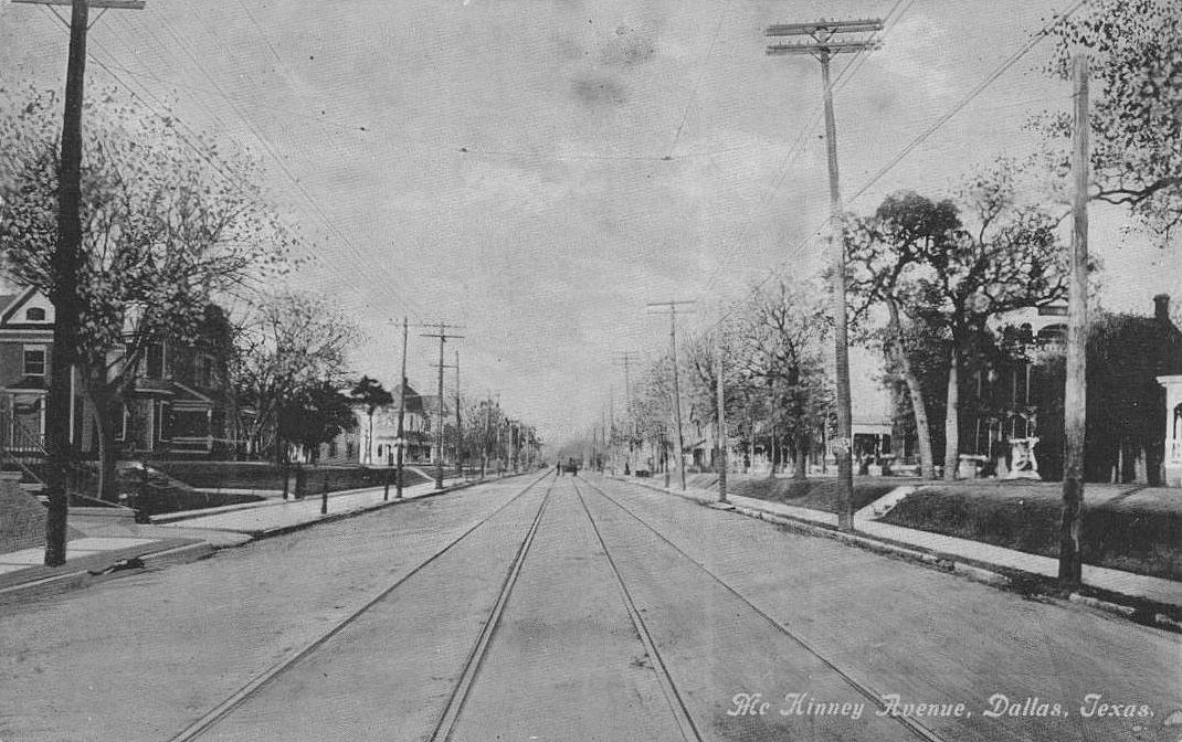
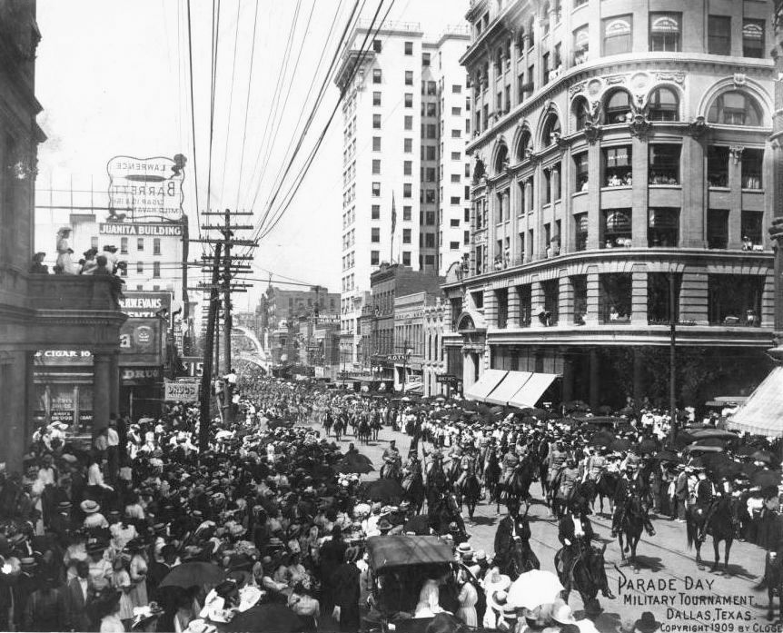
And that is the photo below. It’s a cool photo — there’s some sort of parade underway. This is Elm Street looking toward the east (or, I guess, the southeast), and the photographer is just west of Akard Street. At the bottom left of the photo is the United States Coffee & Tea Co. (which I wrote about here); in the background at the right is the Praetorian Building on Main; and just left of center is the Wilson Building addition under construction (which dates this photo to 1911). But the building that interested me the most is the one at the bottom right, the one at the southeast corner of Elm and Akard. I noticed “Deane’s Photo Studio” on the exterior of the upper part of the building. I recognized the name, having seen it on various Dallas portraits over the years, but now I realize there were two photographers named Deane in Dallas in the first half of the 20th century: Granville M. Deane (who had a longer career here) and his brother, Jervis C. Deane — J. C. Deane was the photographer who occupied the upper-floor studio at 334 Elm (later 1502 Elm) between 1906 and 1911. His studio was above T. J. (Jeff) Britton’s drugstore.

elm-east-from-akard_deane-photography_ca1912_degolyer_SMUElm Street, looking east from Akard, 1911  (DeGolyer Library, SMU)

J. C. Deane (born in Virginia in 1860) worked as an award-winning photographer around Texas, based for much of his career in Waco. He was in Dallas only a decade or so, leaving around 1911, after a divorce, noting in ads that he had to sell his business as he was “sick in sanitarium.” After leaving Dallas he bounced around Texas, working as a studio photographer in cities such as Waco and San Antonio. I have been unable to find any information on his death.

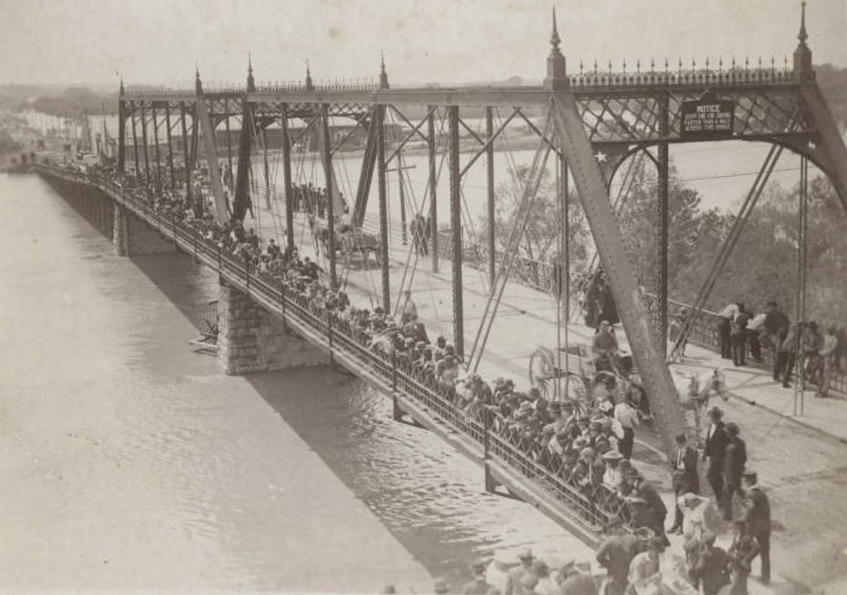
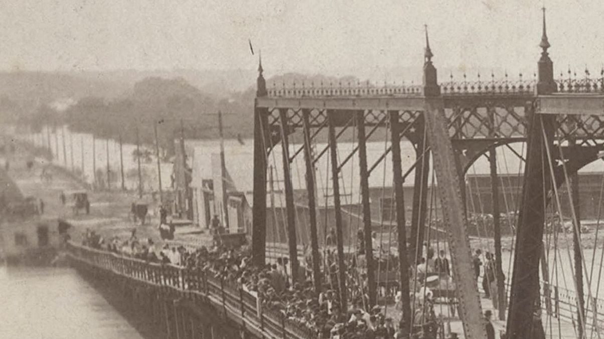
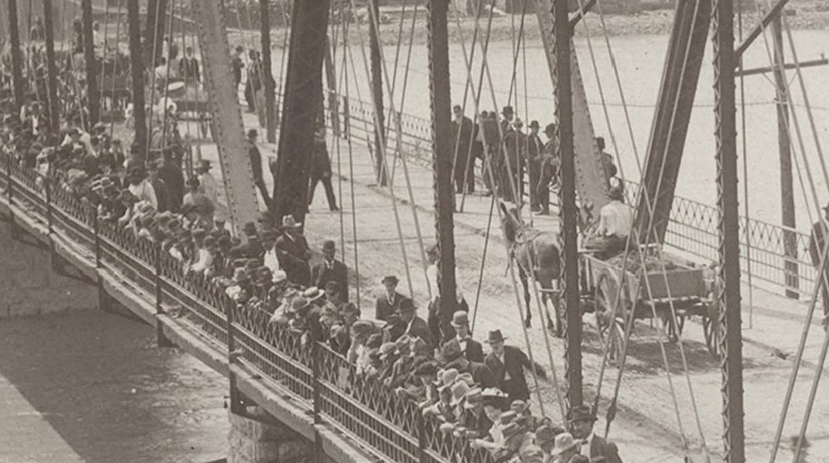
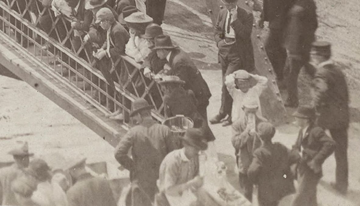
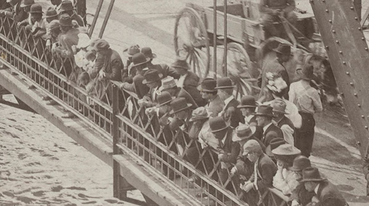
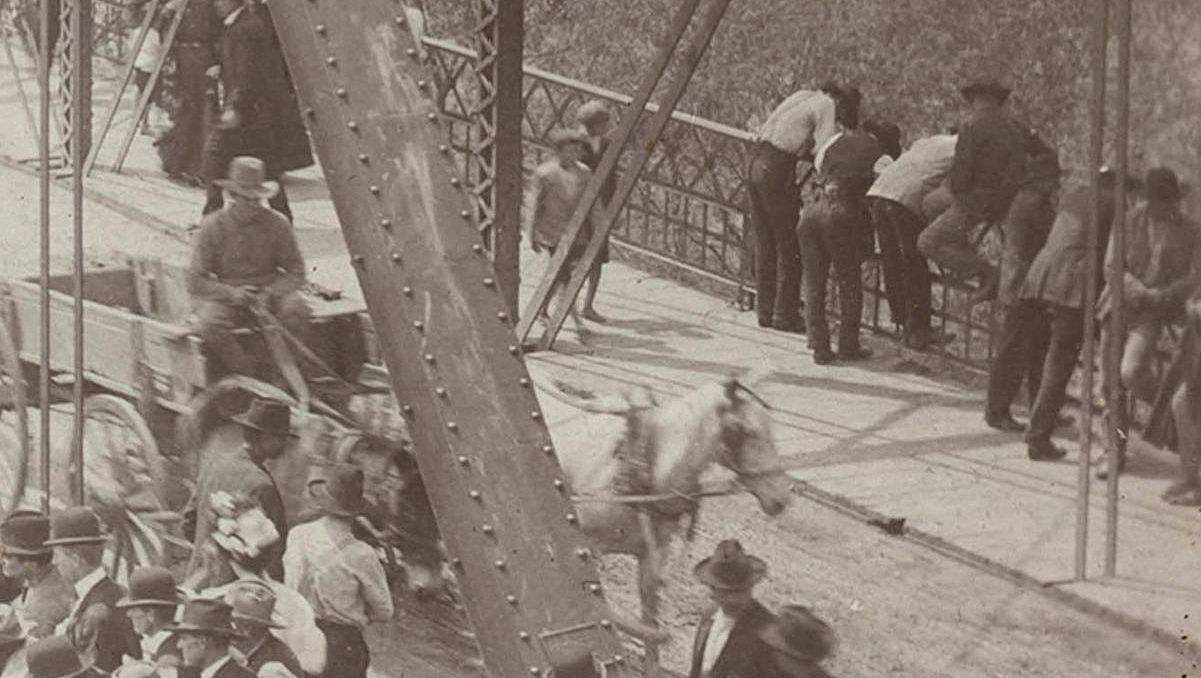
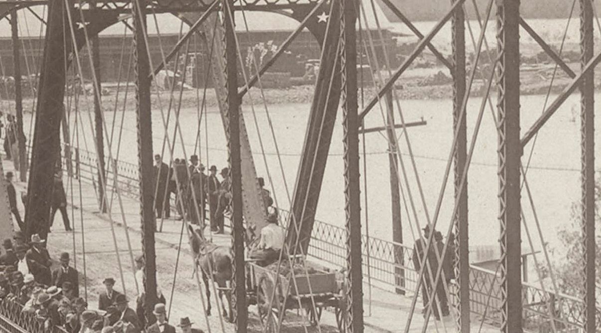
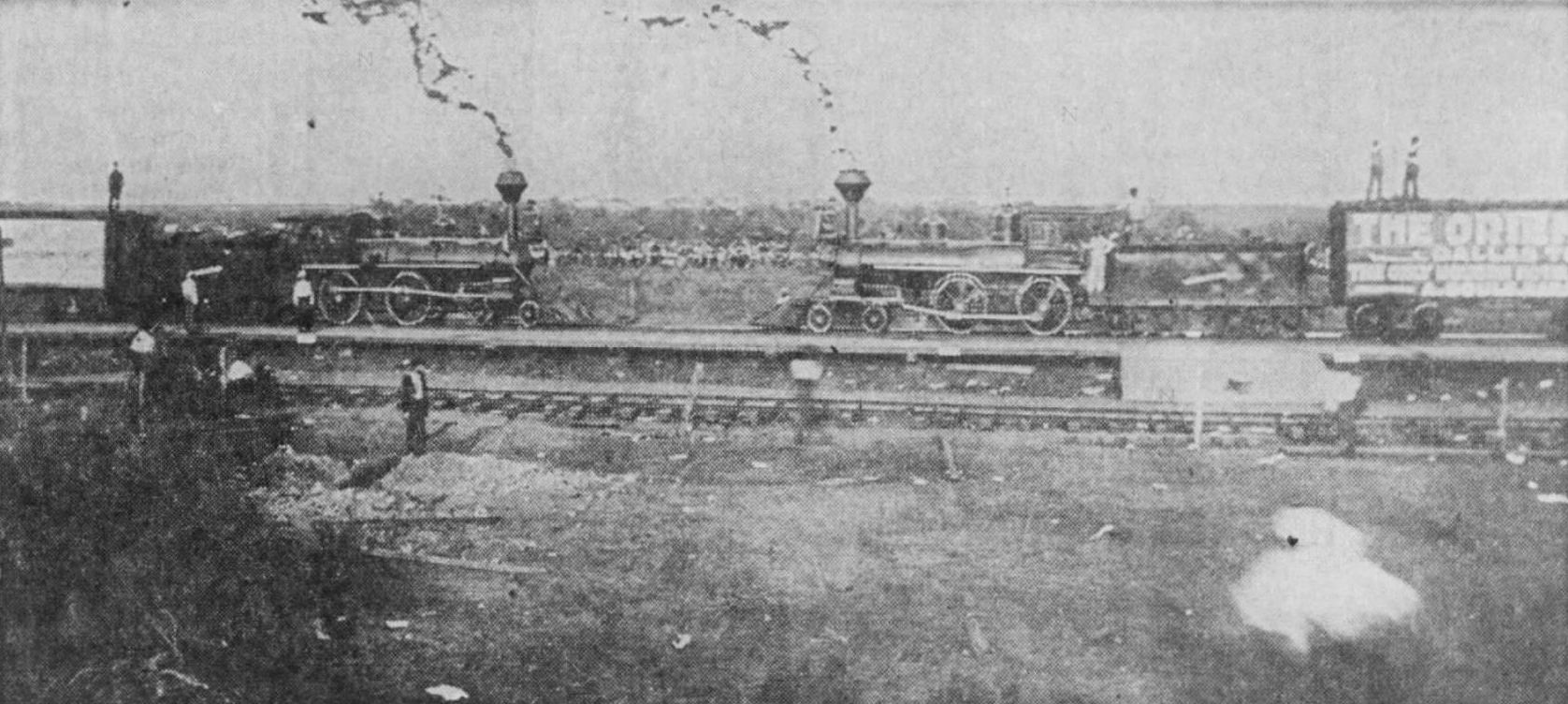
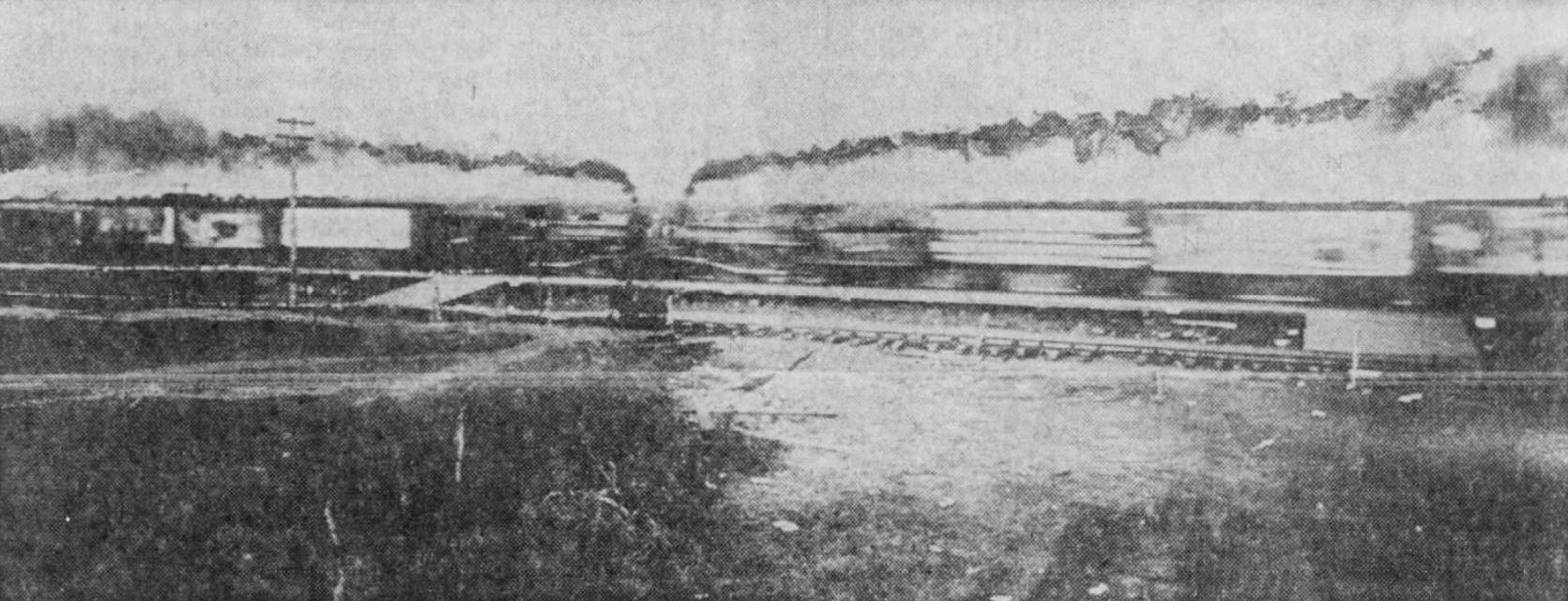
The reason that J. C. Deane holds a place in the annals of weird Texas history? He was one of the photographers commissioned to photograph the supremely bizarre publicity stunt now known as The Crash at Crush, wherein a crowd upwards of 30,000 people gathered in the middle of nowhere, near the tiny town of West, Texas, in September, 1896, to watch the planned head-on collision of two locomotives (read more about this here). Long story short: things did not go as planned, and several people were injured (a couple were killed) when locomotive shrapnel shot into the crowd — one of those badly injured was J. C. Deane who was on a special platform with other photographers. For the sake of the squeamish, I will refrain from the details, but Deane lost his right eye and was apparently known affectionately thereafter as “One Eye Deane.” (For those of you not squeamish, I invite you to read all the gory details, related by Deane’s wife, in an interview with The Dallas Morning News which appeared on October 1, 1896, here.) The photos below are generally credited to Deane, back when he was just good ol’ happy-go-lucky “Two-Eye Jervis.” (All these photos are larger when clicked.) (Scroll down to the bottom of the page for a link to contemporary coverage of the event as reported in The Dallas Morning News.)

deane_crash-at-crush_1_austin-american-statesman_091662Before…

deane_crash-at-crush_2_austin-american-statesman_091662During…

deane_crash-at-crush_3_austin-american-statesman_091662And after…

I’ve been fascinated by the Crash at Crush ever since I heard about it several years ago, and now I know there’s a Dallas connection — and photos of the building where he worked.

Back to Elm Street.

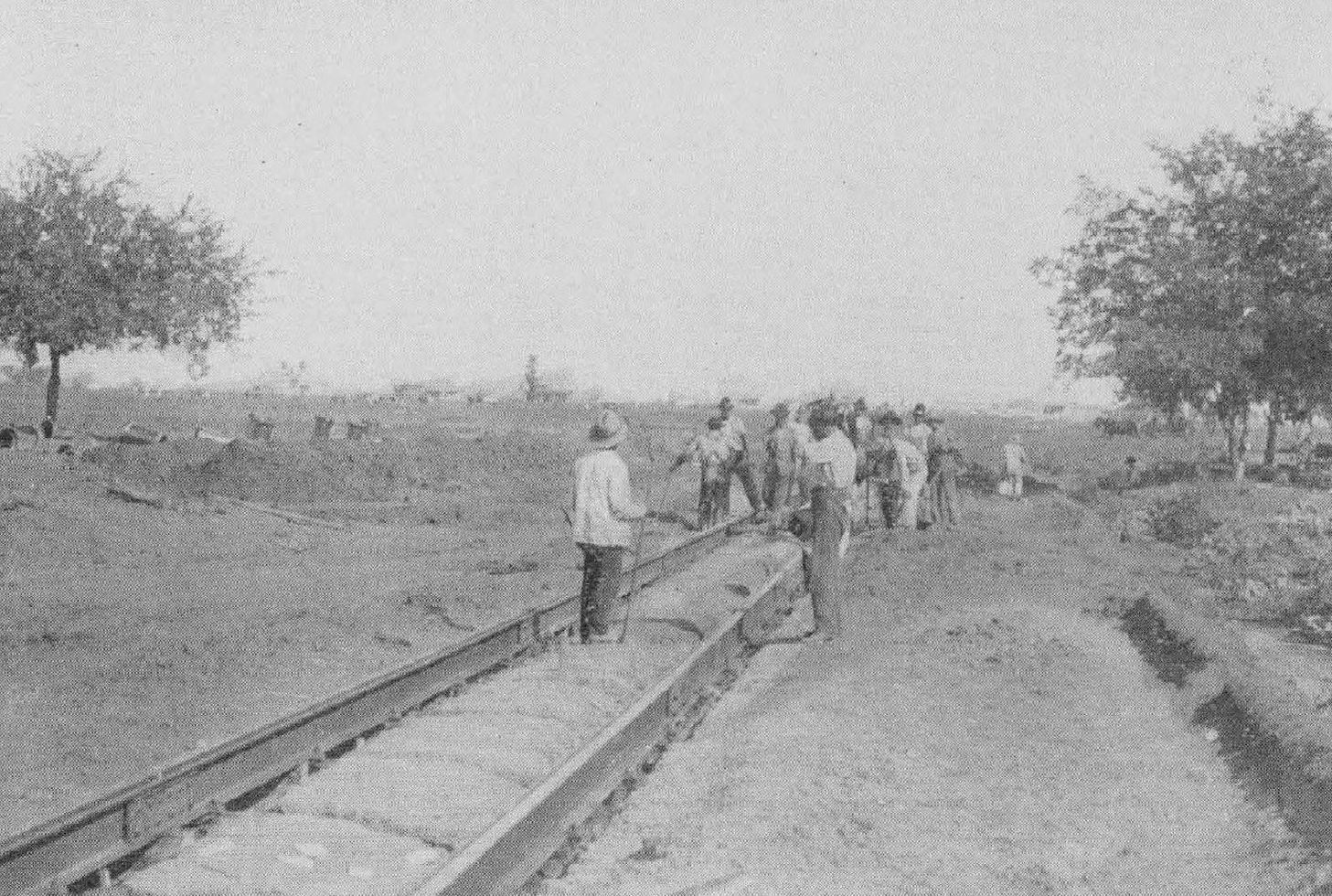
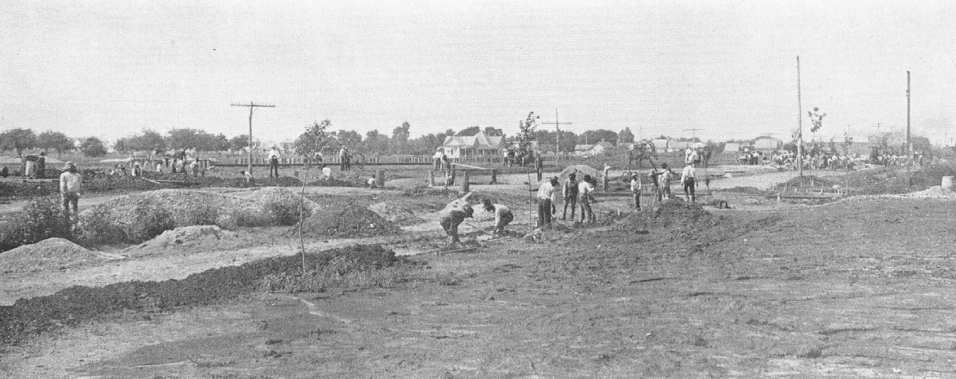
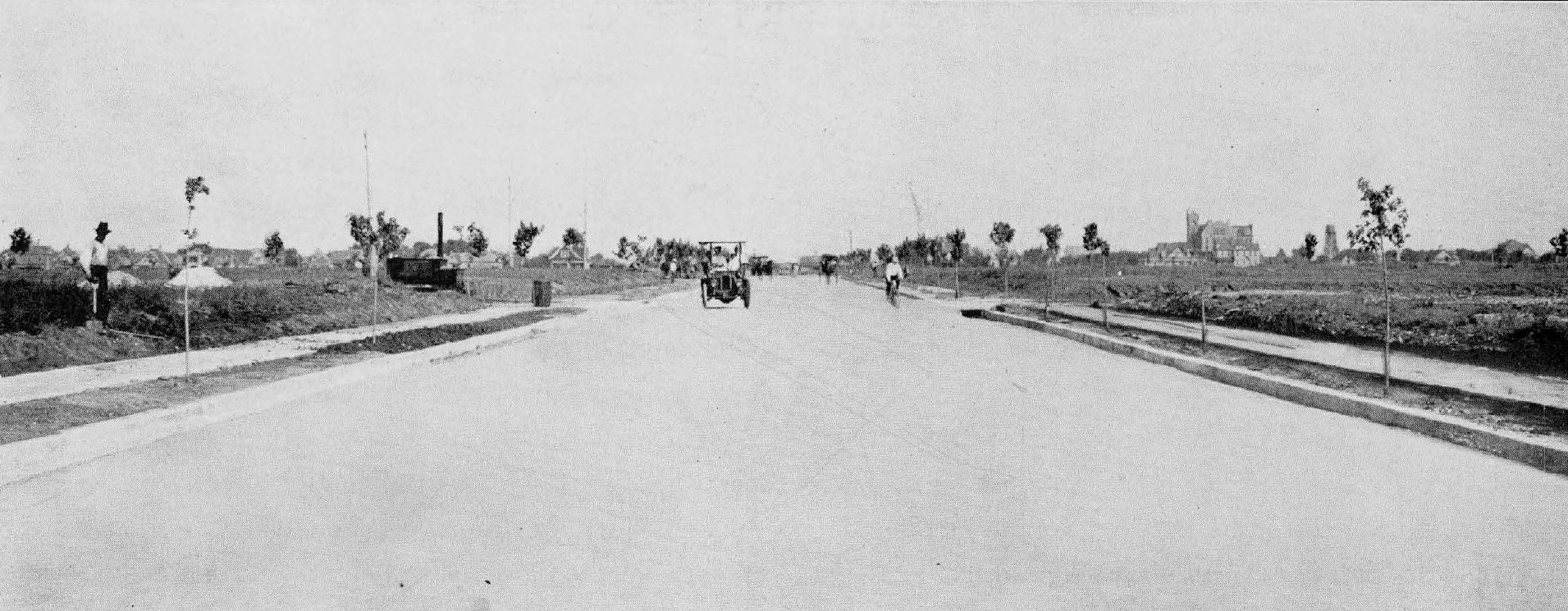
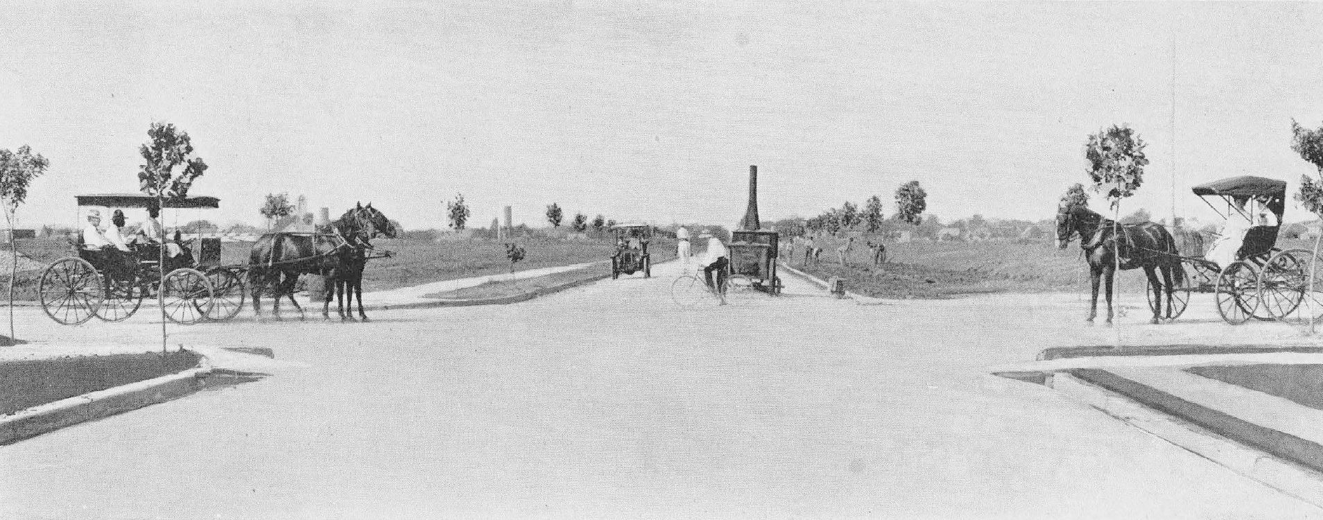
For a brief time (a few months in 1936?) the building was referred to as the “Hutton-Drake Building” and a major renovation of the old building began at the beginning of 1936, when the whole of Dallas was on overdrive to spruce up the city ahead of the crush of Centennial visitors. Here’s an undated “before” photo….

hutton-drake-bldg_jeff-britton_degolyer-lib_SMUvia DeGolyer Library, SMU

The architect’s drawing of the remodeled Deco delight….

hutton-drake-bldg_remodeling_drawing_1936_degolyer-lib_SMUvia DeGolyer Library, SMU

And, because I love this photo so much, here it is again — the finished, revamped building:

elm-and-akard_george-mcafee_degolyer_SMUSoutheast corner of Elm & Akard, 1936/1937, via DeGolyer Library, SMU

What the heck kind of craziness is this?! I mean I LOVE it, but… it’s very… unusual. I would absolutely never have guessed that this building had been in downtown Dallas. And it appears to be the same building seen in the 1911 photo, just with a very fashion-forward new face. Those little hexagonal windows! Along with that fabulous B & G Hosiery sign, there was a nice little bit of art deco oddness sitting there at the corner of Elm and Akard. The Kirby Building, seen at the far right, seems like a creaky older statesman compared to this overly enthusiastic teenager. The businesses seen here — Ellan’s hat shop, B & G Hosiery, and Berwald’s — were at this corner together only in 1936 and 1937. I could find nothing about this very modern facelift — if anyone knows who the architect is behind this, please let me know! (See a postcard which features a tiny bit of this fabulous building here — if the colors are correct, the building was green and white.)

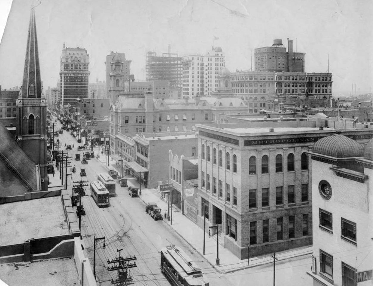
In November, 1941, Elm Street’s Theater Row welcomed a new occupant, the Telenews theater, which showed only newsreels and short documentaries. By that time the A. Harris Co. had purchased the building at the southeast corner of Elm and Akard and expanded into its upper floors. Telenews opened at the end of 1941 and Linen Palace was gone from this Elm Street location by 1943, dating this photo to 1941 or 1942.

theater-row_by-george-mcafee_degolyer_SMUElm Street, 1941/1942  (DeGolyer Library, SMU)

All of these are such great photos. Thanks for making them available to us, SMU!

***

Sources & Notes

The three Dallas photos are from the George A. McAfee collection of photographs at the DeGolyer Library at Southern Methodist University — some of the photos in this large and wonderful collection were taken by McAfee, some were merely photos he had personally collected. The top photo (taken by McAfee) is listed on the SMU database with the title “[Looking Southeast, Corner of Elm and Akard, Kirby Building at Right]” — more info on this photo is here. The second photo, “[Looking East on Elm West of Akard / Praetorian Building (Main at Stone) Upper Right Center]” is not attributed to a specific photographer; this photo is listed twice in the SMU database, here and here. The third photo, “[Looking East on Elm from Akard on “Theatre Row” (Including on North Side on Elm from Left to Right — Telenews, Capitol, Rialto, Palace, Tower, Melba and Majestic],” appears to have been taken by McAfee, and it, too, appears twice in the online digital database, here and here. (I’ve updated this post with additional photos from the DeGolyer Library relating to the building’s remodeling in 1936 — links are below the images.)

The three photos from the “Crash at Crush” event are attributed to Jervis C. Deane, and were taken on September 15, 1896 along the MKT railroad line between West and Waco; the images seen above appeared in the Austin American-Statesman on Sept. 16, 1962. More on the Crash at Crush from Wikipedia, here — there is a photo there of the historical marker and, sadly, Jervis Deane’s name is misspelled. Sorry, Jervis!

Read the Dallas Morning News story of the train collision aftermath in the exciting article lumberingly titled “CRUSH COLLISION: The Force of the Blow and Damage Done. Boilers Exploded with Terrific Force, Scattering Fragments of the Wreckage Over a Large Area. The Showers of Missiles Fell on the Photographer’s Platform Almost as Thick as Hail – Description of the Scene,” here.

The southeast corner of Elm and Akard is currently home to a 7-Eleven topped by an exceedingly unattractive parking garage — see the corner on Google Street View here.

There is a handy Flashback Dallas post which has TONS of photos of Akard Street, several of which have this building in it: check out the post “Akard Street Looking South, 1887-2015,” here.

*

Copyright © 2018 Paula Bosse. All Rights Reserved.

Dallas Ice Factory

dallas-ice-factory_dallas-observer_ebayIce…

by Paula Bosse

Lordy, it was hot today. At one point I looked at my phone and it told me it was 112° (but thanks to the chill factor, it felt like a refreshing 110°). It’s 10:00 p.m. and it’s 100°. That’s too many degrees.

Above is a photo of a horse-drawn Dallas Ice Factory wagon and its driver. There was probably ice in there.

Here’s an ad from 1888 showing the factory:

dallas-ice-factory_1888-directory1888 Dallas directory

Here’s an ad from 1894 not showing the factory:

dallas-ice-factory_1894-directory1894 Dallas directory

Here’s a link to an 1899 Sanborn map showing you where the Dallas Ice Factory was located (in Old East Dallas, at Swiss and Hall): link.

That’s about all I can muster. It’s too dang hot.

***

Sources & Notes

Photo from a 2011 eBay listing, reproduced in The Dallas Observer by Robert Wilonsky; now owned by Peter Kurilecz.

Ads from Dallas directories.

Heat from the sun.

And here’s an ice-factory-related post I actually did some work on, when I wasn’t feeling like a sweaty, limp dishrag (…a long, long time ago…): “Oak Lawn Ice & Fuel Co.”

*

Copyright © 2018 Paula Bosse. All Rights Reserved.

McKinney Avenue Postcard Views

mckinney-avenue_postcard_ebayMcKinney Ave., large houses, streetcar tracks… (click for larger image)

by Paula Bosse

Just a quick post of two picture postcards of McKinney Avenue (the images drained of their added color give a more realistic idea of the original photographs). These views are unrecognizable in today’s Uptown.

mckinney-avenue_postcard_ebay_bw

maple-mckinney_streetcar_ebay

maple-mckinney_streetcar_ebay+bw

***

Sources & Notes

Both postcards found on eBay.

*

Copyright © 2018 Paula Bosse. All Rights Reserved.

Jefferson Dagnal’s Saloon, Deep Ellum — 1906

fritts-and-dagnal_brent-burton
“Fritts & Dagnal,” Deep Ellum saloon… (photo: Brent Burton)

by Paula Bosse

Reader Brent Burton commented on one of my tweets on Twitter to say that he had an old photo showing his great-great-grandfather standing in a saloon he had owned in Dallas around the turn-of-the-century and wanted to know how he might access old Dallas directories in order to try to determine where the bar had been. I told him that online scans of city directories are available for free from the Dallas Public Library and the Portal to Texas History (more on this is in my post How to Access Historical Dallas City Directories Online”). I also offered to see what I could find out.

The photo is the one above (click it to see a larger image). All he knew was that it was taken in a bar owned by his great-great-grandfather Jefferson Davis Dagnall (whose last name is most often spelled “Dagnal” in various documents such as census records, directories, and his death certificate, so I will refer to him with this spelling) and that the photo was taken in the late 1800s or early 1900s. I figured it would be pretty easy to find the info because his name was so uncommon, but that was complicated by the fact that his name was spelled and misspelled many different ways — I think I came across five or six permutations. It took a long time to figure out where that photo was most likely taken — mainly by going through census records and looking at all the city directories — year by year — to pin down where he was working each year. And he got around — he lived at a new address almost every year, and changed jobs almost as frequently.

Jefferson Davis Dagnal was born in 1861, probably in Fort Bend, Texas. His father, a South Carolina native, appears to have died fighting in the Civil War; Jeff (…I call him Jeff…) was 3 years old when his father died. By 1880 he was a teenager, working on a Dallas-area farm. In 1883, Jeff was working as a blacksmith. According to city directories, he held the following jobs: store clerk, laborer, streetcar driver, house-mover, electrician, and bartender.

1905 was the year he seems to have settled into bartending, a job he held in various establishments in Deep Ellum for a decade, until his death in 1915. He appears to have owned (or co-owned) only one of these bars: Fritts & Dagnal. It seems the venture with partner E. G. Fritts was short-lived: its only listing is in the 1906 directory — by 1907 Jeff had moved on, tending bar elsewhere.

1906-directory_dagnal_saloon_fritts-and-dagnal_673-elm

The saloon was listed in the 1906 city directory as being at 673 Elm — that address was changed in 1911 and became 2603 ½ Elm. This was in Deep Ellum, at the northeast corner of Elm and Good (possibly on the second floor). Below is a 1905 Sanborn map showing the location (the full map is here).

673-elm_fritts-and-dagnal_sanborn_sheet-42_1905_det
1905 Sanborn map, detail

The lot that building stood on at Elm and what is now Good-Latimer is empty, but a current-ish look at the location, from Google Street View, can be seen here (I am attempting to post a view from 2015, before all the construction work was going on near the Elm and Good-Latimer intersection — but just move up or down Elm a bit on Google and you’ll see construction images take over).

Below, a couple of ads from around the time Jeff Dagnal and E. G. Fritts decided to start up their short-lived saloon at 673 Elm: the first ad shows that it was not unusual in 1905 for large livestock to be kept in Deep Ellum (where they might even have been “rustled”), and the second ad shows that both the upstairs and downstairs spaces of the building at 673 Elm were available to rent:

1905_673-elm_strayed_dmn_051305Dallas Morning News, May 13, 1905

1906_673-elm_for-rent_dmn_050606DMN, May 6, 1906

(According to the Inflation Calculator, those 1906 rents of $20 and $40 would be about $550 and $1,100 in today’s money.)

Jefferson Davis Dagnal died in Dallas on Feb. 25, 1915. His death certificate — with information provided by his daughter, Cora — listed his occupation as “blacksmith,” even though he had been a bartender (and, briefly, a saloon owner) for at least the last ten years of his life.

1915_dagnal_death_dmn_022615
DMN, Feb. 26, 1915

*

One interesting thing about Mr. Dagnal, was his relationship with his wife Alice, the mother of his second child, Clarence, who was born in 1893. Alice and Jeff appear to have hit a rough patch in their marriage pretty early on. In the 1900 census, they were living in different cities, and each claimed to be widowed. I don’t know if they ever officially divorced (or even if they officially married), but I suppose it was easier in that era to claim a spouse had died rather than admit the shame of divorce or abandonment. By 1903 both were living in Dallas — at the same address. But by 1904 they were living apart, and Alice was, again, claiming to be a widow — even though an alive-and-kicking Jeff was listed in the directory right under her name!

1904-directory_dagnal_alice-and-jeff1904 Dallas directory

I have come across this phenomenon so frequently that I now question every “widow” or “widowed” claim I come across. Information from the U. S. Census (where people give false ages and incorrect marital status ALL THE TIME) should be taken with a grain of salt!

***

Sources & Notes

Photo of Jefferson Dagnal’s saloon was shared with me by Dagnal’s great-great-grandson, Brent Burton and is used here with his permission. Jeff is probably in the photo — in 1906 he would have been 45 years old. Thank you for the great photo, Brent!

All images are larger when clicked.

*

Copyright © 2018 Paula Bosse. All Rights Reserved.


State Fair Coliseum / Centennial Administration Building / Women’s Museum / Women’s Building

tx-centennial_armstrong-linoleum-ad_1936_detAdministration Building interior, 1936…

by Paula Bosse

Thursday night I attended a very entertaining Dallas Historical Society presentation at the Hall of State in Fair Park: “An Evening With Jim Parsons: Lost Fair Park,” in which the author of Fair Park Deco and DFW Deco talked about many of the buildings constructed for the Texas Centennial Exposition in 1936 which are no longer with us.

One of Jim’s asides was that there are very, very few color photos of the Centennial buildings and murals taken in 1936. If you’ve seen a Centennial view in color, it’s probably a colorized postcard. Kodachrome film was introduced in 1935 and was, sadly, not in wide use by visitors to Fair Park in 1936 (or by the Centennial organization).

When he said that, though, I remembered an ad I had come across that I thought was pretty cool, simply because it shows the interior of one of the Centennial buildings when it was brand new (…well, it was sort of new — more on that below). The ad is for Armstrong Linoleum and it features a color photo showing one of their custom linoleum floors installed in the Centennial Administration Building, an interior I’d never seen. And it’s in color! (Check out the furniture and the recessed lighting!) Here’s the full ad, which appeared in national magazines in 1936 (click for larger image).

ad- tx-centennial_armstrong-linoleum_19361936 ad

And — hallelujah — I found another photo of the interior — also from the helpful Armstrong people (I don’t know if they had the concession to outfit all the Centennial buildings, but, if so, I’d love to see all of their designs). Unfortunately this one is not in color, but it shows a fantastic Texas-centric custom design, laid down in fabulous linoleum.

tx-centennial_armstrong-linoleum_admin-bldg_texas-floor

And another one:

tx-centennial_administration-bldg-floor_southwest-business-mag_june-1936
Southwest Business, June 1936

Imagine that floor in Cadet Blue, White, Orange, and Dark Gray. This is from a trade publication called Armstrong’s Floors and Walls for Homes and Public Buildings, published around 1950 (and fully scanned here). A cropped version of the photo of the top is also included here (that floor, by the way, is in White, Dark Gray, and Cadet Blue), with handy swatches (which, reproduced below, lose some accuracy in color).

tx-centennial_armstrong-linoleum_admin-bldg_colors

And just because I found an ad for those cool chairs:

tx-centennial_furniture_southwest-business-mag_oct-1936Southwest Business, Oct. 1936

The Centennial Administration Building — which housed the hundreds of office workers and executives behind the running of the Texas Centennial Exposition — was actually the very first Centennial building completed (at the end of December 1935). Most of the Centennial buildings were newly built in 1936, but the Administration Building was actually an old building given a new stucco façade and completely remodeled — it even acquired a second floor inside the huge structure. This building was originally known as the State Fair Coliseum, built in 1910, designed by architect C. D. Hill (who designed many buildings in Dallas, including the still-standing Municipal Building downtown (built in 1914) and the Melrose Hotel (1924).

state-fair-coliseum_dmn_062009_drawingDallas Morning News, June 20, 1909

state-fair-coliseum_dmn_050710_constructionDMN, May 7, 1910

It was BIG. It had a seating capacity of 7,500.

state-fair-coliseum_flickr_coltera

state-fair-coliseum_dmn_030413DMN, March 4, 1913

This was the first building you’d see as you entered Fair Park, as it was right inside the front entrance on Parry Avenue (after you entered, the building would be on your left).

Coliseum Building, State Fair Dallas, TX

park-board-bk_fair-park-coliseum_1914

It was the city’s first official municipal auditorium, and it hosted everything from livestock shows, conventions, large civic gatherings, and the occasional opera.

Fast-forward a few decades: in 2000 the building became the home of the Women’s Museum. The museum closed in 2011 and is now called the Women’s Building and is used for special events.

A photo of the building from 2014:

womens-museum_fair-park_2014_carol-highsmith_library-of-congressphoto: Carol Highsmith, Library of Congress

See a Wikimedia photo of this building in 2016 here — click it again (and again) to see it really big, and linger on the mural by Carlo Ciampaglia and the sculpture by Raoul Josset. See interior photos of the space in 2009 during its time as the Women’s Museum here and here. I’m not sure if the exposed brick and steel are from the original 1910 building, but I certainly hope so! And, lastly, exterior photos from 2009 showing the side of the building here, and here

***

Sources & Notes

This building can be seen on this aerial Google view, here. It is currently the Women’s Building, and it is available for special events — more about this building from the Friends of Fair Park, here.

Black-and-white postcard showing the interior of the Coliseum is from Flickr.

Black-and-white photo “Coliseum and Art Building” is from Report for the Year 1914-1915 of the Park Board of the City of Dallas, With a Sketch of the Park System (Dallas: Park Board, 1915), which can be accessed as part of the Dallas Municipal Archives via the Portal to Texas History, here.

And since this whole post was spurred by Jim Parsons’ talk the other night, here’s a link to the book he and David Bush wrote: Fair Park Deco: Art & Architecture of the Texas Centennial Exposition.

*

Copyright © 2018 Paula Bosse. All Rights Reserved.

Ghost Rails of the Belmont Streetcar Line

matilda-richmond_dan-parr-photo_FB-dallas-history-guild_april-2018Matilda & Richmond, April, 2018… (photo: Dan Parr)

by Paula Bosse

I grew up on Ellsworth, between Greenville Avenue and Matilda — just south of Mockingbird, just north of the M Streets. When I was a child, Matilda was only partially paved — in my neighborhood, maybe only from Mockingbird down to Kenwood? Otherwise, it was a dirt street (!) — and this was in the ’70s! Right around Kenwood was a weird mound which might not have looked like much to an adult, but to a child it was pretty strange. I can’t remember if the rails were visible — I’m pretty sure they were.

That line was the Belmont Line, which ended (began?) at Mockingbird (I think there was a later extension of sorts, but I think Mockingbird was the end of the line for streetcar passengers). As a kid, I knew that Matilda had been a long-gone streetcar line, but never having seen a streetcar outside of a movie, I couldn’t really imagine what it must have been like to have streetcars (and an interurban! — more on that below) moving up and down a street which was less than a block from my house.

A few years ago I stumbled across the YouTube video below and was surprised to see actual footage of that streetcar rolling up Matilda. The first five minutes of the video contains 16mm footage (both black-and-white and color) shot around Dallas in 1953 and 1954 by Gene Schmidt. It’s GREAT! You’ll see streetcars-galore moving past all sorts of familiar and vaguely familiar sights around the city, from Oak Cliff to downtown to way out to Mockingbird and Matilda. It ends with the Belmont-Seventh car (car 603) pulling to the end of the line — the view is looking south down an unpaved Matilda Street from Mockingbird, with a glimpse of the Stonewall Jackson playing field at the left, on the other side of the fence. (The Matilda footage begins at 4:17.)

*

belmont-line_matilda-from-mockingbird_youtube-cap_ca1954Matilda, south from Mockingbird, ca. 1954 (Gene Schmidt)

Above, a screen capture from the video showing Matilda looking south from just south of Mockingbird. Stonewall Jackson Elementary School is at the left. Today the view looks like this.

*

Before the streetcar arrived, Matilda was the artery that led the Texas Traction Company’s Sherman/Denison interurban into Dallas. This electric interurban service from the north, which closely followed the H&TC railroad line, arrived in Dallas in 1908, back when the official entry-point into the Dallas city limits was just off Matilda, near Greenville Avenue and Bryan Street.

1908_interurban_sherman-dallas_dmn_011608
DMN, Jan. 16, 1908 (click to read)

The interurban route connecting Sherman/Denison with Dallas opened on July 1, 1908 and lasted for 40 years, until its final run on December 31, 1948. (Read the Dallas Morning News article on the 1908 inaugural trip for big-wigs, “Many Make Trip Over Interurban,” July 1, 1908, here. Below is the accompanying photo. Image that running up and down Matilda — and, later, along other streets in Dallas — several times a day!)

interurban_sherman-dallas_dmn_070108
DMN, July 1, 1908

Dallas’ ever-increasing population began to move northward and eastward, necessitating public transportation which would connect these developing areas with the rest of the city. One of the early “suburban” lines was the Belmont Line, which branched off the Bryan Street line and served the Belmont Addition and beyond; it opened in 1913, but these early days appear to have been more of a private “dinky” service (see SMU’s dinky car on the beyond-the-city-limits tracks at Hillcrest and McFarlin, here). The Belmont line — as well as the Vickery Place and Mount Auburn lines — became part of the city’s official streetcar system in 1922.

Before the dinky service, riders were able to get on and off the large interurban cars at stops between Mockingbird and the area around Bryan and Greenville Ave. Even though interurbans and streetcars were able to travel on the same rails, it took years for dedicated streetcar tracks to be laid along Matilda.

This detail of a real estate ad shows that the Belmont line had reached at least as far as Richmond by 1914 (I felt I had to include this because the finger is pointing at the exact location of the exposed rails in the photo at the top!):

1914_matilda-richmond_lakewood-heights-ad_det_050314
May, 1914 (detail from Lakewood Heights real estate ad — see full ad here)

By 1922 the Belmont line had extended north to Velasco; by 1925 it had gotten to McCommas; by 1936 it had made it up to Penrose; and by 1939 it had finally reached Mockingbird (in time for the opening that year of Stonewall Jackson Elementary School, located at Mockingbird and Matilda).

Dallas streetcars began to be phased out in 1955, and the Belmont line was one of the first to go — its last run was March 6, 1955: “The Belmont-Seventh streetcar line will go out of existence Sunday to be replaced by service with new Diesel buses” (Dallas Morning News, March 6, 1955). The new bus route in the Lower Greenville area would, for the most part, be along Greenville Avenue, one block west of unpaved Matilda Street.

In March, 1955, it was reported that the abandoned Belmont-Seventh streetcar tracks were deeded to the city by the Dallas Railway and Terminal Co., with the understanding that they would eventually be paved over. The tracks were on Matilda, Bryan, Cantegral, Live Oak, St. Paul, King’s Highway, Edgefield, Seventh, Bishop, and Colorado. In April, 1956, it was reported that the City Council had approved the sale of the streetcar viaduct over the Trinity River and the Matilda street right-of-way.

But what about that paving of Matilda? Mrs. K. E. Slaughter had thoughts on the matter in a letter-to-the editor in April, 1955:

Since removal of the Belmont streetcar line in part — Matilda and Bryan streets — would it not be advantageous to develop this section into an important use to the heavy automobile traffic? Matilda now is no more than useless tracks built up between a cow path. (DMN, April 7, 1955)

“Cow path” — ha!

Another annoyed News reader wrote in 1963 — eight years after the tracks had been abandoned — about the useless unpaved thoroughfare:

The abandoned almost-private right of ways, such as Matilda, nearly two miles south from Mockingbird, received by the city in a deal to permit an all-bus operation, have not yet been paved or otherwise improved. (DMN, Oct. 21, 1963)

I’m not sure when that paving finally happened — early ’70s? — I think it must have been done in stages. I don’t remember a time when the stretch between Mockingbird and Kenwood wasn’t paved, but I do remember Matilda being a dirt road south of Kenwood. I don’t have a good recollection of the year, but kids remember all sorts of weird things, and those mysterious mounds were pretty memorable. (UPDATE: See photos of Matilda being paved at Goodwin in 1971 here.) I wish I’d known what an interurban was when I was a child. That would have made my neighborhood seem a whole lot more interesting! Heck, it used to the Gateway to Sherman!

I’ve long despaired of having missed the streetcar age. But it’s nice to know that one ran so close to the house I grew up in.

belmont-line_matilda-mockingbird_youtube-cap_ca1954End of the line, ca. 1954… (Gene Schmidt)

belmont-car_lakewood-heights-ad-det_050314

***

Sources & Notes

Top photo taken by Dan Parr on April 15, 2018; it was originally posted to the Facebook group Dallas History Guild and is used here with permission. (Thanks, Dan!) The photo was taken at Matilda and Richmond, looking south on Matilda. See it on Google Street View, here. (Roadwork along Matilda is awful at the moment, but much-needed. Apparently it is being reduced to three lanes for automobiles with two bike lanes being added — read about it in the Lakewood Advocate, here.)

YouTube video shot by Gene Schmidt in 1953 and 1954; the direct link is here.

Another interesting video on YouTube was made by the City of Allen and contains period footage of the interurban that served North Texas. It’s a breezy 6-and-a-half  minutes, and it includes some cool shots of Dallas.

If you want to see a whole bunch of North Texas interurban photos, check out this great 83-page PDF compiled by DART, “History of the Interurban Railway System and Monroe Shops,” here.

Speaking of DART, they posted a cool 1925 map of streetcar and interurban lines, here — click the map to see a larger image. (In 1925, the Belmont line ended on Matilda at McCommas).

ALSO extremely cool is a Google map showing Dallas’ Historical Streetcar (and Interurban) Lines laid over a present-day Google map, here. Zoom in and out. Very useful!

streetcar_belmont_color_ebayeBay

belmont-streetcar_new-moon_1940_palace_ebay1940, eBay

belmont-streetcar_1954_ebay1954, eBay

*

Copyright © 2018 Paula Bosse. All Rights Reserved.

Oakland Cemetery

oakland-cemetery_postcard

by Paula Bosse

A beautiful postcard showing the gates of Oakland Cemetery emblazoned with the name of one of Dallas’ most prominent funeral directors, George W. Loudermilk.

oakland_loudermilk_dmn_060102Dallas Morning News, June 1, 1902

ad-loudermilk-funeral-home_19061906 ad

loudermilk_dmn_071912DMN, July 19, 1912

***

Sources & Notes

More on historic Oakland Cemetery, in South Dallas:

  • Wikipedia, here
  • Dallas Genealogical Society, here
  • Oakland Cemetery website, here
  • A lovely YouTube video filled with photographs of the cemetery and its markers, here

You can explore parts of the cemetery by touring via Google Street View, here.

*

Copyright © 2018 Paula Bosse. All Rights Reserved.

Munger Place, The Early Days: 1905-1909

munger-place-bk_ca-1905_degolyer-lib_SMU_construction_1Munger Place, the beginning…

by Paula Bosse

Here are a few photos from a great item found in the collection of SMU’s DeGolyer Library: a promotional booklet on the wonders to be found at the new East Dallas development called Munger Place. The photos show the construction of what would become one of the most exclusive neighborhoods in Dallas, developed by Robert S. Munger (of Continental Gin Co. fame) and his son C. H. Munger. (His son’s first name was “Collett” — as in “Collett Avenue,” which I had always thought was named after one of the elder Munger’s daughters. But it turns out that “Collett” was the maiden name of C. H.’s mother. I’ve only ever heard the street name pronounced like the woman’s name “Colette,” but I have a feeling it might have originally been pronounced as rhyming with “wallet.”) (UPDATE: According to a Munger relative, the street name *should* actually be pronounced to rhyme with “wallet.”)

munger-place-bk_ca-1905_degolyer-lib_SMU_cover

Location, location, location. Not quite within the city limits at this time, but close. (All images are larger when clicked.)

munger-place-bk_ca-1905_degolyer-lib_SMU_location

*

munger-place-bk_ca-1905_degolyer-lib_SMU_construction_2Caption: “At work.”

*

munger-place-bk_ca-1905_degolyer-lib_SMU_pavingPaving.

*

munger-place-bk_ca-1905_degolyer-lib_SMU_street-railway-constructionCaption: “Building street railroad.” (This appears to be Collett Avenue.)

*

munger-place-bk_ca-1905_degolyer-lib_SMU_collett-and-juniusCaption: “At work at intersection of Collett Avenue and Junius Street.”

*

munger-place-bk_ca-1905_degolyer-lib_SMU_collett-and-junius_2Caption: “Collett Avenue, looking toward St. Mary’s from Junius Street.”

*

munger-place-bk_ca-1905_degolyer-lib_SMU_gaston-and-collettCaption: “Gaston Avenue — looking toward the city at intersection of Collett Avenue.” (Today this intersection looks like this.)

*

munger-place-bk_ca-1905_degolyer-lib_SMU_swiss-avenueCaption: “Swiss Avenue — this was a corn field, with barb wire fences and hedges, about a year ago.”

*

munger-place-bk_ca-1905_degolyer-lib_SMU_map

Map of Dallas, circa 1905, with Munger Place highlighted.

munger-place-bk_ca-1905_degolyer-lib_SMU_map-det

*

Think you might want to live in “The Place”? Here’s who you need to contact (interesting that the Walter Caruth house is mentioned here…):

munger-place-bk_ca-1905_degolyer-lib_SMU_developer

Collett Henry Munger — who lived in Munger Place, at 5400 Swiss — died from a heart attack at the young age of 48.

munger-collett_photo
C. H. Munger (1879-1928)

*

The earliest mention of “Munger Place” I found in The Dallas Morning News was this classified from May 21, 1905:

munger-place_dmn_052105_early-mentionMay 21, 1905

Work was well underway by 1906:

munger-place_dmn_090106DMN, Sept. 1, 1906

A call for “an expert landscape gardener” went out that same year:

munger-place_dmn_101406_landscaperOct. 14, 1906

Not yet ready for lots to go on sale, the public was invited to head to East Dallas to take a look at the progress (“bring your friends and visitors to the Fair”).

munger-place_dmn_102106Oct. 21, 1906

This rendering of the Swiss Avenue entrance was, interestingly, prepared by the architectural firm of Sanguinet, Staats & Hill, who designed several Munger Place residences (including Collett Munger’s).

munger-place_dmn_010107_renderingDMN, Jan. 1, 1907

A sort of “teaser” ad (with a great photo of the intersection of Swiss and Munger) appeared in March, 1907:

munger-place_dmn_032407_ad_photoMarch 24, 1907

In April, 1907, it was announced that finally lots would be available for purchase (but only 40…), with big discounts for those who promised to build immediately.

munger-place_dmn_041407_adApril 14, 1907

“Let it rain…. NO MUD IN MUNGER PLACE at any time.” Apparently a big selling point in 1907!

munger-place_dmn_050307_no-mudMay 3, 1907

By 1909 things were really starting to come together for what quickly became one of the most exclusive (and highly restricted…) neighborhoods in the entire city.

munger-place_worleys-1909-directoryWorley’s Dallas directory, 1909 ad

***

Sources & Notes

Photos of Munger Place under construction, map, and text on yellow background are from the promotional booklet “Munger Place: Dallas, Texas,” from the collection of the DeGolyer Library, Central University Libraries, Southern Methodist University; the entire booklet has been scanned by SMU and is available for free download here.

The last image is an ad from the 1909 Worley’s Dallas directory.

Read “Munger Place: Report of Nomination for Landmark Designation as a City Historic District” prepared by the City of Dallas Department of Urban Planning (1980), here.

More on Munger Place and the Munger family can be found is these Flashback Dallas posts:

  • “Munger Place — 1908,” here
  • “Munger’s Improved Continental Gin Company,” here

All images are larger when clicked.

*

Copyright © 2018 Paula Bosse. All Rights Reserved.

The Prelude to the Great Flood of 1908

commerce-st-bridge_1908_cook-degolyerApril 20, 1908… (click for larger image) / SMU

by Paula Bosse

The greatest flood Dallas has ever known — the disastrous flood of 1908 (read about it here) — happened in the spring of 1908. The Trinity River reached its highest crest of more than 52 feet on May 26. The photo above was taken on April 20 — five weeks before that.

On April 20, 1908 — the day this photo was taken — The Dallas Morning News reported that after three weeks of rain the Trinity had finally crested at “nearly 39 feet.” This flooding was the worst in 20 years and the third worst on record.

In a mere five weeks, though, every record regarding the Trinity River and flooding in Dallas would be broken. Those people who had ventured out to survey the river from the Commerce Street Bridge that April day had no idea what was in store for them in just 35 days.

Let’s zoom in on this photo and look at some of the details of the crowd and the bridge (all images are larger when clicked).

commerce-st-bridge_1908_cook-degolyer-det1

commerce-st-bridge_1908_cook-degolyer-det2

commerce-st-bridge_1908_cook-degolyer-det3

Above: are refreshments being sold?

commerce-st-bridge_1908_cook-degolyer-det4

commerce-st-bridge_1908_cook-degolyer-det5

commerce-st-bridge_1908_cook-degolyer-det6

commerce-st-bridge_1908_cook-degolyer-det7

“NOTICE: $25.00 FINE FOR DRIVING FASTER THAN A WALK ACROSS THIS BRIDGE.”

commerce-st-bridge_1908_cook-degolyer-det8

**

The editorial cartoon below appeared on the front page of The Fort Worth Telegram next to a story with the headline “Dallasites Flee Flooded Homes; River is Rising.”

flood_FWST_042008_help-them
FWT, April 20, 1908

In May, this photo (by Henry Clogenson) showing “Highest Water in the History of Dallas” appeared in The Dallas Morning News:

flood_dmn_052608_clogenson_commerce-st-bridge
DMN, May 26, 1908

Another photo by Clogenson:

trinity-river_flood_1908_LOC-lg

For comparison, here’s the bridge at a calmer time:

commerce-street-bridge_legacies_fall-1995

Flood memorabilia? Check out the book and stationery department at Sanger Bros.

flood_postcard-sales_dmn_060408_sangers-ad-detJune, 1908

***

Sources & Notes

Top photo titled “Commerce St. Bridge, Trinity River, Dallas, Tex., April 20, 1908” from the George W. Cook Dallas/Texas Image Collection, DeGolyer Library, Central University Libraries, Southern Methodist University; the photo and more information can be accessed here.

The wide-angle photo of the Commerce Street Bridge, taken by Henry Clogenson, is from the Library of Congress, here.

“Calmer” photo of the Commerce Street Bridge is from the Fall, 1995 issue of Legacies, from the article “Bridges Over the Trinity” by Mary Ellen Holt.

Read the Dallas Morning News article “Trinity Flood Crest Has Reached Dallas … Great Damage is Reported” (DMN, April 20, 1908) here.

*

Copyright © 2018 Paula Bosse. All Rights Reserved.

“A Glimpse of Dallas” — ca. 1909

postcard_charles-e-arnoldCommerce Street, looking west from St. Paul…

by Paula Bosse

This very attractive postcard shows a growing downtown Dallas, looking west from Commerce and St. Paul, photographed by Charles E. Arnold from the YMCA building (which once sat in the block now occupied by the Statler). The Wilson Building can be seen at the top right, the Praetorian Building (then the tallest building in the city) is to its left, and the Post Office and Federal Building is in the center. The photo was probably taken in 1909 or 1910 (the Praetorian was completed in 1908 and the Adolphus Hotel (not seen in this postcard) was under construction in 1911.

The photo below, taken by Jno. J. Johnson from the exact same vantage point, shows the many changes to the skyline which happened over a very short span of time. The photo below is from about 1913.

new-skyline_c1912_degolyer_smuvia DeGolyer Library, SMU

I zoomed in on this photo in a previous post, “Horses, Carriages, Horseless Carriages: Commerce Street — 1913,” here.

The large “Barrett Cigar” sign seen in the top postcard image is also visible in a 1909 photo by Clogenson, below — it can be seen at the left, atop the Juanita Building on Main Street, opposite the Praetorian.

parade-day_1909_clogenson_degolyervia DeGolyer Library, SMU

I zoomed in on this photo in the post “Parade Day — 1909,” here.

This was the beginning of staggering growth for Dallas, and new skyscrapers seemed to be going up every month.

***

Sources & Notes

I came across the postcard image a couple of years ago — I noted that the photographer was C. E. Arnold, but I did not note the source.

The two photos are from the DeGolyer Library, Central University Libraries, Southern Methodist University; further information on each photo can be found at the links posted immediately below the images.

All images are larger when clicked.

*

Copyright © 2018 Paula Bosse. All Rights Reserved.