Flashback : Dallas

A Miscellany: History, Ads, Pop Culture

Category: Neighborhoods

The Eccentric Medford Compound On the Old Eagle Ford Road: 1945-1950

medford_trinity-cafe_west-dallas_FB_dallas-historyYou need it, he’s got it…

by Paula Bosse

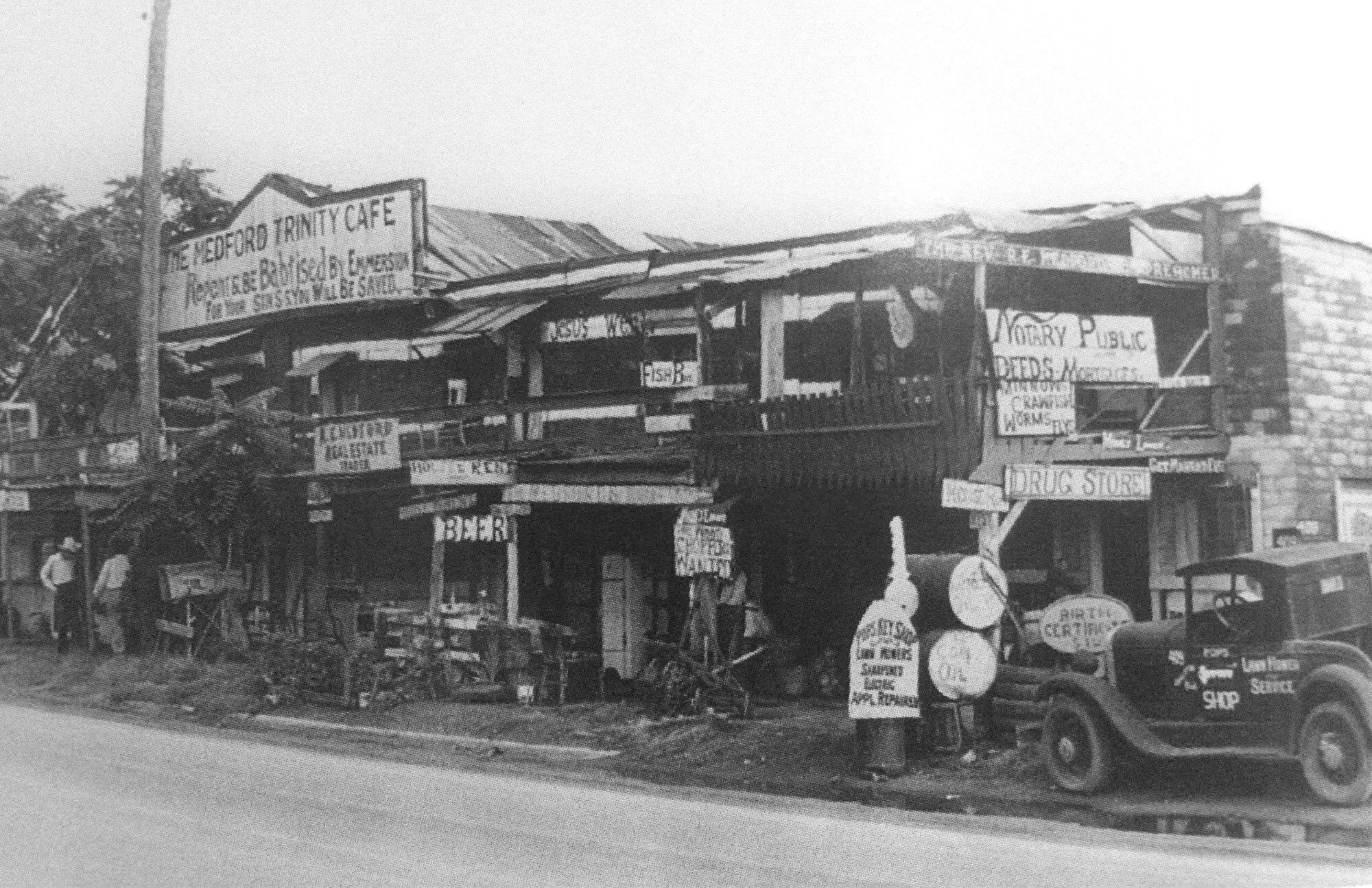
Above, 409-413 Singleton Blvd. in West Dallas, not long after the name of the street had been changed from Eagle Ford Road. The name-change happened in 1942 because of “unfavorable incidents in the past which had been associated with Eagle Ford Road” (The Dallas Morning News, April 26, 1942) — “Singleton” was Vernon Singleton, a former Oak Cliff County Commissioner. Today, this area is part of the super-hipstery Trinity Groves neighborhood; the block seen in the photo is now mostly occupied by a parking lot and looks like this.

Back then, “Eagle Ford Road” would have conjured up all sorts of unsavory images of bad behavior and illegal activities, and, even now, one tends to think immediately of the area’s most notorious exports: Bonnie and Clyde. Immediately after World War II, the population of West Dallas (an area which would not become part of the City of Dallas until its annexation in December 1952) was about 12,000, and its residents were generally poor and living in substandard housing with inadequate water and drainage and little in the way of sanitary facilities.

The “complex” above — which consisted of, basically, the Trinity Cafe, a grocery/drug/dry-goods store, and a residence — was perhaps a bit more colorful than most of the businesses that lined Eagle Road/Singleton Blvd. in post-war West Dallas. The property was owned by Richard Elbert Medford (1864-1950), who, as one of the signs says, was also known as “The Rev. R. E. Medford, Preacher” (I’m not sure if he was an actual ordained minister or just a self-styled preacher). In 1944 or 1945 — after several years of selling mattresses — Medford took over the collection of rickety buildings seen in the photo above and began to sell a wide-ranging collection of unrelated stuff and painted a lot of signs. He remained in business there until his death in 1950 at the age of 86 (the cause of death was “senile exhaustion” which I gather means “died of old age”).

The signage in the photo is … well … it’s fantastic. It’s verging on Outsider Art. Medford offered everything, including (but not limited to):

  • Real estate
  • Beer
  • Notary Public services (deeds, mortgages, birth certificates…)
  • Keys
  • Appliance repair
  • Lawn mowers
  • Oil
  • Fish bait (minnows, crawfish, worms, and “flys”)

He also offered religious advice (“Repent & Be Babtised By Emmersion For Your Sins You Will Be Saved”).

Mr. Medford’s personal life was not a happy one, and perhaps the unrelenting family dramas caused him to become more and more eccentric as the years went by. Many of his children found themselves caught up in the crime and violence West Dallas had become known for.

  • One teenage son was shot and wounded during an attempted robbery in 1930, two months before one of his daughters married at the age of 13.
  • Another son, who was 11 years old, was killed when he attempted to intervene in a fight between his sister and her husband and was fatally kicked in the abdomen by his brother-in-law.
  • Another son was a habitual criminal who committed an eye-popping range of crimes and was in and out of city, county, state, and federal correctional facilities throughout his life. (This son, Homer, was also married for a short time to the ex-wife of Clyde Barrow’s brother L. C. Barrow, but that marriage hit the skids when she shot Homer, sending him to the hospital with critical — but not fatal — wounds.)
  • And in 1951, after Rev. Medford’s death, the son who had been shot in 1930 while attempting to break into a store in Irving, shot and killed his wife and young son before killing himself.

So, yeah, Rev. Medford’s life was a rough one, and there were definitely some dark days in hardscrabble West Dallas. I’d like to think his store, plastered with its kooky signs, offered him some respite from the incessant melodramas percolating all around him.

medford_trinity-cafe_west-dallas_1940s
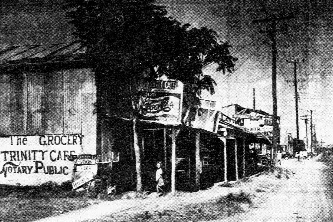
Singleton Blvd., late 1940s, not yet part of Dallas

*

The location of the Medford house/cafe/store, seen on a 1952 Mapsco (click for larger image).
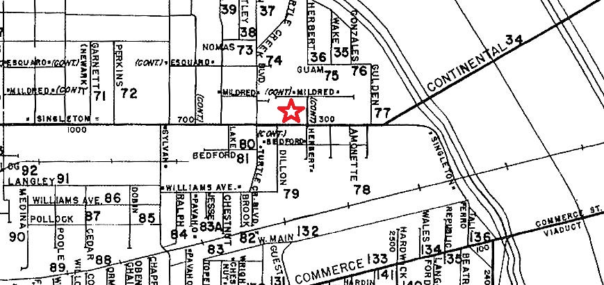
medford_1952-mapsco1952 Mapsco

***

Sources & Notes

I came across the photo years ago on the Dallas History Facebook group. There was no source, but there appears to be a copy of this photograph in the Jim Doster Collection at the Dallas Public Library titled “Meford [sic] Trinity Cafe on Singleton Blvd.,” incorrectly dated as 1930 (call number PA97-7/147). I’m sure a higher resolution image of this would offer up quite a few amusing details and discoveries.

*

Copyright © 2018 Paula Bosse. All Rights Reserved.

The Ray Hubbard Estate, Lakewood

ad-evervess_mrs-ray-hubbard_1948_detA country estate in the heart of Lakewood, 1948… (click for larger image)

by Paula Bosse

Lakewood has a lot of beautiful homes — large and small — but the (very large) Raymond E. Hubbard estate at the corner of Lakewood Boulevard and Brendenwood Drive is quite the show-stopper. Built in 1934, the two-and-a-half-acre property is about a mile from White Rock Lake and was known for years for its spectacular landscaping and gardens, much of which was the personal handiwork of owner Ray Hubbard (1893-1970). Hubbard amassed his wealth as an independent oilman during the boom years, but he was known in his later life for his lengthy tenure as president of the Dallas Park Board.

From a 1938 Dallas Morning News article:

Mr. Hubbard is that phenomenon known as a natural tiller of the soil. In the short space of two years he has taken a barren hill and transformed it into a blaze of beauty in the form of a rock garden he designed himself. In the symphony of color, he has even had the subtlety to plant a few onions because there is a blue-green cast to the leaves of the onion that is found in no other plant. Carnations, pansies and pinks mingle in profusion as well as a thousand other oddities you have never seen the likes of  before. (“Edens in Preview,” DMN, April 10, 1938)

In 1948, his wife, Janet Hubbard, was seen in an ad for Evervess Sparkling Water, with photos of both Mrs. Hubbard and a view of the impressive “backyard” of their Lakewood home. (Click ad to see larger image.)

ad-evervess_mrs-ray-hubbard_1948Saturday Evening Post, 1948

I came across this ad a few years ago but had no idea where the house was located or who Ray Hubbard was, other than the probable namesake of the lake which bears his name (the Rockwall-Forney reservoir was named Lake Ray Hubbard in January, 1967, in honor of Hubbard’s devotion to civic affairs and his decades-long service to Dallas parks). I was surprised to learn that this was the somewhat mysterious and foreboding-looking house I’d passed years ago, looking run-down and deserted, surrounded by overgrown shrubs and bushes. The 2012 Google Street View looked like this:

hubbard-house_google-street-view_oct-2012Google Street View, Oct. 2017

Back then the overgrown approach to the house looked like this, and was probably something of a thorn in the side of the Lakewood Boulevard residents.

Since Google Street View was so out-of-date, I decided to drive by the house today to see what it looked like in 2018. It’s beautiful!

hubbard-house_lakewood-blvd_031519_PBphoto: Paula Bosse

The reason for the transformation? The property was bought and restored by Hunter Hunt (grandson of one-time richest man in the world — and White Rock Lake resident — H. L. Hunt) and his wife, Stephanie Hunt. And they did a wonderful job! If I had some, I’d raise a toast to the couple with an ice-cold glass of Evervess Sparkling Water!

ray-hubbard-estate_google-earth_2017
Google Earth, 2017

*

hubbard_ray-e-hubbard_find-a-grave

Even though I now know who Ray Hubbard was, I’ll probably still find myself unintentionally (and, okay, sometimes intentionally) calling the lake named after him “Lake Ray Wylie Hubbard” (another former Dallas resident of note, but we’ll leave that for another time…).

***

Sources & Notes

Ad found on eBay. This image is from an item offered several years ago, but as luck would have it, another seller has it for sale right now, here. Perhaps if you’re friends with Hunter and Stephanie Hunt, this would make a nice stocking stuffer. (This Evervess advertisement seems to have been part of a 1948 ad campaign featuring society women, their homes, and their favorite sparkling water: another ad, featuring Mrs. Homer Lange and her Chicago home, can be seen here.)

Photo of Ray E. Hubbard is from Find-a-Grave; read a biographical sketch about Mr. Hubbard’s life on the site, here. Not included in this information was that during Hubbard’s 27 years heading the Park Board (1943-1970), the Dallas park system expanded from 4,400 acres to more than 15,000 acres, and the number of parks increased from 54 to 150.

Read about Stephanie and Hunter Hunt and their Hunt Institute at SMU, here.

If anyone knows the original architect of the Hubbard house, please let me know!

For more on Lakewood Boulevard, I really enjoyed the 1992 Lakewood Advocate article “Lakewood Boulevard’s First Resident Looks Back On the Area’s Development; Mrs. Barnett’s Late Husband, Marshall, Built the First House on Lakewood Boulevard in the 1920s,” here.

See a 1932 view of the 7100 block of Lakewood Blvd. (with White Rock Lake at the end of the street), here; this photo was taken two years before the construction of the Hubbards’ house, which would  be built three blocks to the west (Dines and Kraft photo from the Flashback Dallas post “‘Reminiscences: A Glimpse of Old East Dallas,'” here).

*

Copyright © 2018 Paula Bosse. All Rights Reserved.

The Heart of Big “D”: Akard & Commerce

downtown_heart-of-big-d_postcard_akard-commerceLooking up the “canyon”… (click for larger image)

by Paula Bosse

A postcard view of Akard, looking north from Commerce; the “canyon” is anchored at the south end by the Baker Hotel (behind the photographer), the Walgreens in the Adolphus Hotel building, and the Continental Air Lines ticket office in the Magnolia Building.

Looks like a hot, painfully sunny day in the canyon. Personally, I’d get out of the sun and hit that soda fountain….

***

Sources & Notes

This postcard is currently being offered on eBay, here. The seller is in Transylvania.

The Continental Air Lines ticket office opened in the Magnolia Building in early 1958 (click for larger image).

continental-air-lines_jan-1958
January, 1958

For more info on the buildings that lined the “canyon,” see the Flashback Dallas post “The ‘Akard Street Canyon’ — ca. 1962,” here.

*

Copyright © 2018 Paula Bosse. All Rights Reserved.


The Adolphus Hotel’s “Coffee Room” — 1919


coffee-room_adolphus_tea-and-coffee-trade-journal_march-1919_photo
Jonesing for some java? Belly on up…

by Paula Bosse

You know who was really, really happy about Prohibition? The coffee, tea, and soft drink industries. In fact, they were absolutely giddy. And, believe it or not, Dallas County prohibited the sale of alcohol even before much of the rest of the country — Dallas became officially “dry” in October 1917.

Have you ever wondered what happened to the nation’s thousands and thousands of bars when it became illegal in the United States to sell alcoholic beverages? What about all the hotel bars? Apparently, many hotels renovated their old bars into something new and novel called a “coffee shop” or a “coffee room.”

The photo above shows what the vested interests of The Tea & Coffee Trade Journal deemed “the coffee room” of the elegant Adolphus Hotel.

coffee-room_adolphus_tea-and-coffee-trade-journal_march-1919Tea & Coffee Trade Journal, March 1919

Yes, there were coffee urns, and coffee was certainly sold there, but it was actually the Adolphus Lunch Room. Though beverages are not mentioned in the menu seen below, it’s interesting to read what dishes were available to the Adolphus visitor in 1919 (of course the really well-heeled guests were not noshing in a lowly — though quite attractive — “lunch room”). The most expensive item on the menu is the Adolphus Special Sunday Chicken Dinner for 90¢ (which the Inflation Calculator tells us is the equivalent of about $13.00 today). (Click to see a larger image.)

adolphus_lunch-room_menu_dec-1919
Dec. 1919

And, yes, I believe that is a spittoon at the register.

**

I wonder if that “coffee room” later became the Adolphus barbershop (seen below)? Or maybe the barbershop became the coffee room?

adolphus-barber-shop_childers_adolphus-archives

***

Sources & Notes

Photo from the article “The Renaissance of Tea and Coffee” from The Tea & Coffee Trade Journal (March 1919). See other photos and read how Prohibition was spurring on this alcohol-free “renaissance” in the article, here.

Photo of the Adolphus barbershop appeared in the book Historic Dallas Hotels by Sam Childers, credited to the Adolphus Archives.

Many, many historical photos of spittoons can be found in this entertaining collection of the once-ubiquitous cuspidor. …Because when else will I be able to link to something like this?

As a sidenote, the Adolphus Hotel was, of course, built by and named for Adolphus Busch, the co-founder of Anheuser-Busch. Mercifully, the beer magnate died pre-Pro — before Prohibition.

*

Copyright © 2018 Paula Bosse. All Rights Reserved.

The Elks Lodge, Pocahontas & Park

elks-lodge_postcard1817 Pocahontas Street, 1914 (click for larger image)

by Paula Bosse

The postcard image above shows the lovely Dallas Elks Lodge No. 71 which once stood at 1817 Pocahontas, at the northwest corner of Pocahontas Street and Park Avenue in the Cedars area, just south of downtown — it had a spectacular view of City Park, which it faced.  Designed by architect H. A. Overbeck (the man behind the still-standing Dallas County Jail and Criminal Courts Building and the long-gone St. Paul’s Sanitarium), the lodge was built in 1914; the land and the construction of the lodge cost $45,000. Surprisingly, this lodge served the Elks for only six years — they returned downtown, where they took over and renovated the old YWCA building on Commerce Street.

The building on Pocahontas became another clubhouse when it was purchased in 1920 by a group of Jewish businessmen who opened the exclusive Progress Club/Parkview Club (read about the building’s acquisition in a May 14, 1920 article in The Jewish Monitor, here); in 1922 the 65 members of the Parkview Club presented the clubhouse to the Young Men’s Hebrew Association (YMHA). In 1927, use of the building had expanded, and it became the Dallas Jewish Community Center and the headquarters of the Jewish Welfare Federation — in fact, this was the home for these organizations for more than thirty years, until 1958 when the move was made to the new Julius Schepps Community Center in North Dallas. The building ultimately fell victim to the construction of R. L. Thornton Freeway and was demolished in the early 1960s.

But back to the Elks. The Benevolent and Protective Order of Elks was a social club/fraternal order founded in New York in 1868. Dallas Lodge No. 71 was chartered on January 28, 1888 — it was the first Elks Lodge in Texas and one of the oldest clubs in Dallas. And, after 130 years, it’s still around, now located in Lake Highlands. There aren’t a lot of things that have lasted that long in this city!

*

Below, the Overbeck rendering of the Elks’ new home (click for larger image)

elks_dmn_120213_new-lodgeDallas Morning News, Dec. 2, 1913

*

A week before its official dedication on Sept. 7, 1914:

elks-lodge_dmn_083014DMN, Aug. 30, 1914

*

Colorized and made into an attractive postcard:

elks-club_new_postcard

*

In the 1930s, when it was the Jewish Community Center:

jewish-community-center_1817-pocahontas_1930s

*

Where it was:

elks-lodge_ca-1912-map_portal1912-ish map detail

Also, see it on the 1921 Sanborn map (as “B.P.O.E. Home”) here.

**

The announcement of plans for the construction of the Pocahontas Street lodge:

elks_dmn_112313_new-lodgeDMN, Nov. 23, 1913

And its dedication, on Sept. 7, 1914:

elks_dmn_090814_new-homeDMN, Sept. 8, 1914

***

Sources & Notes

Source of postcards unknown. Other images and clippings as noted.

The 1888 report of the first meeting of the Dallas Elks Lodge No. 71 can be read in the Dallas Morning News article “Order of Elks in Dallas; A Lodge Instituted Here Yesterday” (DMN, Jan. 29, 1888), here.

A history of the various Elks’ locations in Dallas between the 1880s and the 1920s can be found in the article “Elks Plan To Have Modern Club Home” (DMN, July 30, 1922), here.

elks_dmn_012903DMN, Jan. 29, 1903

*

Copyright © 2018 Paula Bosse. All Rights Reserved.

Munger Place, The Early Days: 1905-1909

munger-place-bk_ca-1905_degolyer-lib_SMU_construction_1Munger Place, the beginning…

by Paula Bosse

Here are a few photos from a great item found in the collection of SMU’s DeGolyer Library: a promotional booklet on the wonders to be found at the new East Dallas development called Munger Place. The photos show the construction of what would become one of the most exclusive neighborhoods in Dallas, developed by Robert S. Munger (of Continental Gin Co. fame) and his son C. H. Munger. (His son’s first name was “Collett” — as in “Collett Avenue,” which I had always thought was named after one of the elder Munger’s daughters. But it turns out that “Collett” was the maiden name of C. H.’s mother. I’ve only ever heard the street name pronounced like the woman’s name “Colette,” but I have a feeling it might have originally been pronounced as rhyming with “wallet.”) (UPDATE: According to a Munger relative, the street name *should* actually be pronounced to rhyme with “wallet.”)

munger-place-bk_ca-1905_degolyer-lib_SMU_cover

Location, location, location. Not quite within the city limits at this time, but close. (All images are larger when clicked.)

munger-place-bk_ca-1905_degolyer-lib_SMU_location

*

munger-place-bk_ca-1905_degolyer-lib_SMU_construction_2Caption: “At work.”

*

munger-place-bk_ca-1905_degolyer-lib_SMU_pavingPaving.

*

munger-place-bk_ca-1905_degolyer-lib_SMU_street-railway-constructionCaption: “Building street railroad.” (This appears to be Collett Avenue.)

*

munger-place-bk_ca-1905_degolyer-lib_SMU_collett-and-juniusCaption: “At work at intersection of Collett Avenue and Junius Street.”

*

munger-place-bk_ca-1905_degolyer-lib_SMU_collett-and-junius_2Caption: “Collett Avenue, looking toward St. Mary’s from Junius Street.”

*

munger-place-bk_ca-1905_degolyer-lib_SMU_gaston-and-collettCaption: “Gaston Avenue — looking toward the city at intersection of Collett Avenue.” (Today this intersection looks like this.)

*

munger-place-bk_ca-1905_degolyer-lib_SMU_swiss-avenueCaption: “Swiss Avenue — this was a corn field, with barb wire fences and hedges, about a year ago.”

*

munger-place-bk_ca-1905_degolyer-lib_SMU_map

Map of Dallas, circa 1905, with Munger Place highlighted.

munger-place-bk_ca-1905_degolyer-lib_SMU_map-det

*

Think you might want to live in “The Place”? Here’s who you need to contact (interesting that the Walter Caruth house is mentioned here…):

munger-place-bk_ca-1905_degolyer-lib_SMU_developer

Collett Henry Munger — who lived in Munger Place, at 5400 Swiss — died from a heart attack at the young age of 48.

munger-collett_photo
C. H. Munger (1879-1928)

*

The earliest mention of “Munger Place” I found in The Dallas Morning News was this classified from May 21, 1905:

munger-place_dmn_052105_early-mentionMay 21, 1905

Work was well underway by 1906:

munger-place_dmn_090106DMN, Sept. 1, 1906

A call for “an expert landscape gardener” went out that same year:

munger-place_dmn_101406_landscaperOct. 14, 1906

Not yet ready for lots to go on sale, the public was invited to head to East Dallas to take a look at the progress (“bring your friends and visitors to the Fair”).

munger-place_dmn_102106Oct. 21, 1906

This rendering of the Swiss Avenue entrance was, interestingly, prepared by the architectural firm of Sanguinet, Staats & Hill, who designed several Munger Place residences (including Collett Munger’s).

munger-place_dmn_010107_renderingDMN, Jan. 1, 1907

A sort of “teaser” ad (with a great photo of the intersection of Swiss and Munger) appeared in March, 1907:

munger-place_dmn_032407_ad_photoMarch 24, 1907

In April, 1907, it was announced that finally lots would be available for purchase (but only 40…), with big discounts for those who promised to build immediately.

munger-place_dmn_041407_adApril 14, 1907

“Let it rain…. NO MUD IN MUNGER PLACE at any time.” Apparently a big selling point in 1907!

munger-place_dmn_050307_no-mudMay 3, 1907

By 1909 things were really starting to come together for what quickly became one of the most exclusive (and highly restricted…) neighborhoods in the entire city.

munger-place_worleys-1909-directoryWorley’s Dallas directory, 1909 ad

***

Sources & Notes

Photos of Munger Place under construction, map, and text on yellow background are from the promotional booklet “Munger Place: Dallas, Texas,” from the collection of the DeGolyer Library, Central University Libraries, Southern Methodist University; the entire booklet has been scanned by SMU and is available for free download here.

The last image is an ad from the 1909 Worley’s Dallas directory.

Read “Munger Place: Report of Nomination for Landmark Designation as a City Historic District” prepared by the City of Dallas Department of Urban Planning (1980), here.

More on Munger Place and the Munger family can be found is these Flashback Dallas posts:

  • “Munger Place — 1908,” here
  • “Munger’s Improved Continental Gin Company,” here

All images are larger when clicked.

*

Copyright © 2018 Paula Bosse. All Rights Reserved.

Forest Avenue-Area Flooding, South Dallas — 1935

flooding_forest-avenue_lloyd-long_052035_ebayBeyond the levees… (click for larger image)

by Paula Bosse

Sometimes the Trinity River is a puny little trickle, sometimes it’s a raging torrent. Here are aerial photos taken from around Forest Avenue (now MLK Blvd.) by Lloyd M. Long, showing the major flooding of May, 1935.

Here is the lead sentence from The Dallas Morning News, May 21, 1935 (the day after these photos were taken):

With sections of South Dallas inundated for the first time since the record 1908 flood, numerous bridges and highways and thousands of acres of lowlands hidden by its swirling, muddy currents, the roaring Trinity slowly was receding Monday night at Dallas after reaching a crest of 42.10 feet at 11 a.m. (DMN, May 21, 1935)

flooding-levee-district-from-forest-ave_lloyd-long_052035_ebay

There was great rejoicing that that the new-ish levees had held the waters and prevented the wide-scale flooding seen in 1922. But once you got to the Forest Avenue bridge (which ran below the Corinth St. viaduct and the Santa Fe railroad trestle), things got real bad real fast. In the photo above, the levee protection ends exactly at the railroad trestle — the Forest Avenue bridge is mostly underwater. The river above the trestle: a beautiful feat of engineering; below: water, water everywhere.

Below the Forest Ave. bridge where the levee protection ended, flood conditions were far worse than those created by the 1922 inundation. (DMN, May 21, 1935)

Again, sometimes the Trinity is just a trickle….

***

Sources & Notes

Both photos (by Lloyd M. Long) are from 2017 eBay auctions: the top photo here, and the bottom photo here.

More on Dallas flooding can be found in these Flashback Dallas posts:

  • “The Nellie Maurine: When a Pleasure Boat Became a Rescue Craft During the Great Trinity River Flood of 1908,” here
  • “One of the Victims of the Great Trinity Flood: The T & P Railroad Trestle — 1908,” here
  • “The Trinity River at the City’s Doorstep,” here
  • “Cole Park Storm Water Detention Vault,” here

Maybe it’s just me, but I was really taken with that little L-shaped building in the top photo which was, briefly, its own island. What was it? It was part of the Guiberson Oil Well Specialty Corporation, founded in 1919 at 1000 Forest Avenue — the building seen in the photo was built in 1926. It’s still standing (here) and appears to be part of Faubion & Associates, a manufacturer of retail display cases and store fixtures.

Click photos to see larger images.

*

Copyright © 2018 Paula Bosse. All Rights Reserved.

900 Block of Main, North Side — 1952

AR447-B1201Main Street, 1952… (Squire Haskins Collection, UTA)

by Paula Bosse

This 1952 photo by Squire Haskins shows the north side of Main Street, taken at the intersection with Poydras, looking west to the old Dallas County jail and criminal courts building seen at the far left. The Sanger’s building stands just west of Lamar, and across Lamar is the 900 block of Main, with the legendary E. M. Kahn men’s clothing store (one of Dallas’ first important retail stores, founded in 1872), the Maurice Hotel (in the old North Texas Building, built in 1888/1889), and the large Bogan’s grocery store at the northwest corner of Main and Poydras. The old jail and the Records Building (way in the distance) and the Sanger’s building are all that remain. See how this view looks today, here.

There is a flyer for “Porgy and Bess” on the lamppost in front of the Bogan market. “Porgy and Bess” opened the State Fair Summer Musicals series at the State Fair Auditorium (Music Hall) in June, 1952 (see an ad here).

But what about the south side of the 900 block of Main Street? Thankfully, photographer Squire Haskins  not only took the photo above, he also turned to face the other side of the street and snapped companion photos. I posted two of his photos of the south side of Main in a previous post, here. Here’s one of those photos, with Poydras at the left and Lamar on the right:

main-poydras_squire-haskins_uta

A listing of the businesses from the 1953 city directory — there’s a little bit of everything (click to see larger image):

900-block-main_1953-directory

***

Sources & Notes

Both photos by Squire Haskins, both from the Squire Haskins Photography, Inc. Collection, University of Texas at Arlington. More info on the top photo can be found here; more on the second photo, here.

More on the south side of Main Street can be found in the Flashback Dallas post “900 Block of Main Street, South Side — 1950s,” here.

All images larger when clicked.

*

Copyright © 2018 Paula Bosse. All Rights Reserved.

McKinney & Haskell, Circle “T” Frozen Foods, and VWs in Dallas

mckinney-and-haskell_NDHS_ebayFender-bender in front of NDHS… (click for larger image)

by Paula Bosse

Odd stuff shows up on eBay. This photo shows a damaged Circle T Brand frozen-food Volkswagen delivery van at the intersection of McKinney Avenue and North Haskell (with North Dallas High School making a partial cameo in the background). The view today? See it here.

Circle T was one of the many brainchilds of the Southland Corp.’s Thompson family: it manufactured and distributed frozen foods (initially meats and Mexican food) which were sold in the company’s 7-Eleven stores. The company began in 1954 and was located just a couple of blocks from this photo, at Haskell and Central. (In 1954 they announced one of their first specialty products: frozen queso. I’ve never even considered that frozen queso would exist, but 60-some-odd years ago it was flying off shelves at the neighborhood 7-Eleven.)

The Southland Corp. sold off Circle T in 1966.

Below, an ad for Circle T’s frozen steaks, from 1954 (click ad to see larger image).

cicle-t_FWST_062054June, 1954

circle-t-logo_1954

And because I’m nothing if not pedantic, here’s an ad for VW trucks and vans, from 1961 (which appears to be the date on the van’s license plate in the photo):

volkswagen_ad_fen-1961Feb., 1961

And speaking of Volkswagens, the first Dallas car dealer to import Volkswagens appears to be Clarence Talley — the first ads are from 1954. While I was searching for the link to the eBay listing of the above photo (which I could not find…), I serendipitously stumbled across this 1950s photo of Clarence Talley on N. Pearl, with appearances by the Medical Arts Building and the Republic Bank Building. Thank you, eBay.

talley-volkswagen_ebay

***

Sources & Notes

Photos from eBay: could not find the link to the first one, but the second one sold a couple of months ago, and the archived listing is here.

*

Copyright © 2018 Paula Bosse. All Rights Reserved.

The Magnolia Cafe, N. Lamar & Munger — 1947

magolia-cafe_1947_ebayStep in for a cool glass of Metzger’s Milk…

by Paula Bosse

I love stumbling across photos of random small businesses. This photo from 1947 shows an interesting modification of a rooming house in the area immediately north of downtown at 1914 N. Lamar, at the corner of what is now N. Lamar and Munger (the curb shows “Caruth St.,” the street’s original name). Unsurprisingly, this former residential area — which became an industrial warehouse district — looks pretty different today (see the current Google Street View here). A succession of cafes operated here over the years (while people lived in rented rooms upstairs) since at least 1927.

I love the entrance to the rooming house with the concrete steps to the right of the cafe, the street light, the streetcar tracks, The Metzger’s Milk sign, the Stier’s Laundry truck, the parked cars, and the street names (probably in tile?) on the curbs.

Three years after this photo was taken, the building was up for sale:

magnolia-cafe_nov-1950_bldg-for-sale1950

Its future? A parking lot.

A longtime owner of this combo building was Mrs. Ella Mae Stuart, who was living there with her husband as early as 1913 (possibly 1909). After her husband’s death in 1915, she ran a boarding house upstairs and rented out the cafe below. She seems to have been a much-married woman who was very creative with her age as given to census takers: every 10 years she continued to grow younger and younger, ending up in 1930 with her age listed as 50. She died three years later at the actual age of 68, leaving behind a husband 26 years her junior. Her great stamina might be the result of her regular consumption of a wonder tonic called Konjola (a patent medicine popular during Prohibition, made from roots, herbs, and a lot of alcohol). (Click to read Mrs. Stuart’s testimonial.)

e-m-stuart_konjola-ad_1930
1930

***

Sources & Notes

Photo from eBay; taken by Rogers Studio (the business owned by noted Dallas photographer Frank Rogers and his son Norman Rogers), with the date “May 8, 1947” stamped on the back. Also on the back of the photo: “Magnolia Cafe, Lamar and Munger; seating capacity: 32.”

See the building on the 1921 Sanborn map here, which shows 1914 N. Lamar at the corner of Caruth Street. It appears the house might have become renovated to include a cafe on the ground floor in 1926 or 1927 when one of Mrs. Stuart’s boarding-house roomers opened up Frank’s Lunch Room.

*

Copyright © 2018 Paula Bosse. All Rights Reserved.