The next several weeks will be spent immersed in the gargantuan task of helping my mother sell her house and move, so new posts might be a bit sporadic for a while, and I might be relying on older posts to fill the gaps.
Time for a few more newly-stumbled-across bits and pieces to add to old posts.
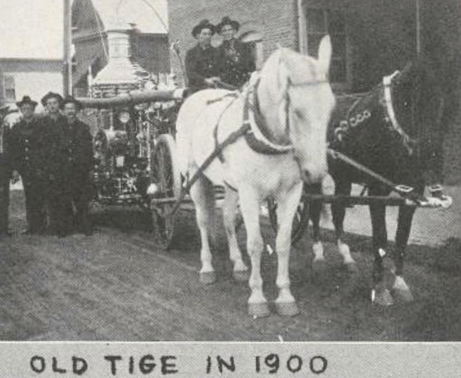
The photo above shows “Old Tige,” the 600 gallons-per-minute steam pumper, built in 1884, which was in service with the Dallas Fire Department until 1921 (it can be seen today at the Dallas Firefighters Museum). I’ve added this photo to the post “Dallas Fire Stations — 1901.” (Source: The Man in the Leather Helmet, A Souvenir Booklet of The Dallas Fire Department, 1931, via the Portal to Texas History, here.)
*
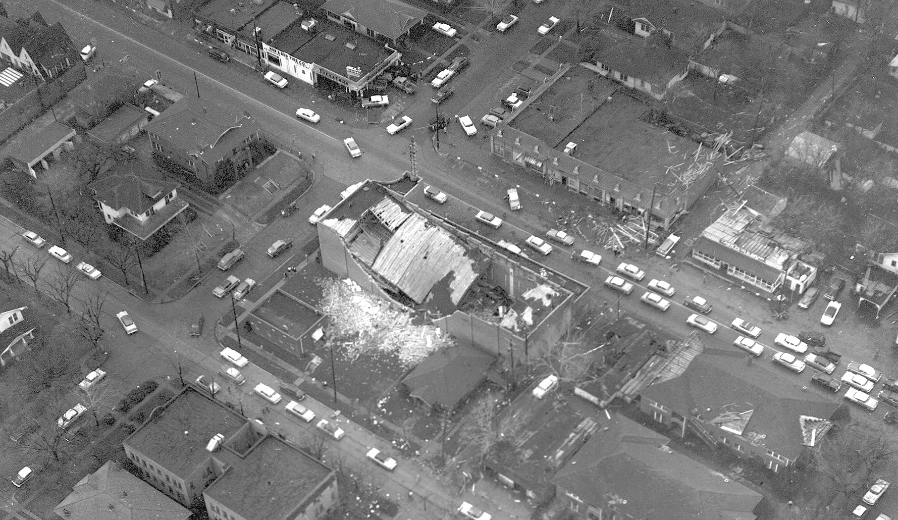
Below, the aftermath of the 1957 tornado that hit Oak Cliff, with the damaged Kessler Theater in the center. This detail of a larger photo has been added to “Back When the Kessler Couldn’t Catch a Break — 1957.” (Source: Squire Haskins photograph, from the University of Texas at Arlington Libraries — the full very large photo can be seen by clicking the thumbnail image here.)
*
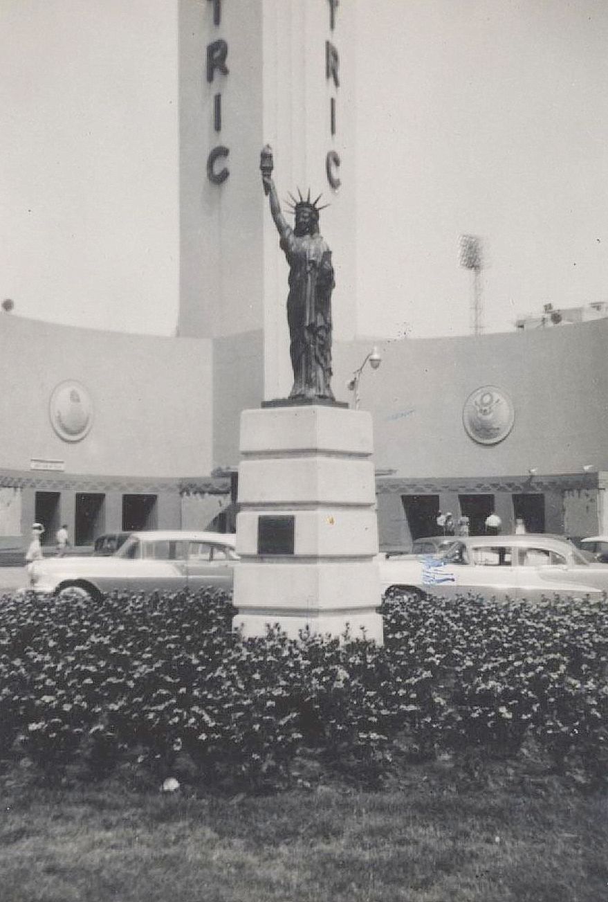
This 1956 photo of the small Statue of Liberty replica presented to the State Fair of Texas by the Boy Scouts of Circle Ten Council on July 4, 1950 has been added to “Fair Park’s Statue of Liberty.” (Source: eBay)
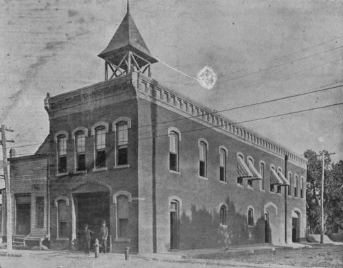
This photo of Station No. 11 at Cedar Springs and Reagan (which opened in 1909 and is still in operation!) has been added to “No. 4 Hook and Ladder Company, Oak Lawn — 1909.” (Source: The Man in the Leather Helmet, A Souvenir Booklet of The Dallas Fire Department, 1931, via the Portal to Texas History)
*
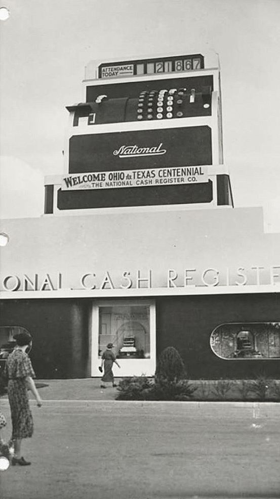
I keep coming across photos of the huge NCR cash register which kept track of attendance at the Texas Centennial. Who doesn’t love a kooky giant cash register? I’ve added these two photos to “The Giant Cash Register at the Texas Centennial — 1936.” (Source: George W. Cook Dallas/Texas Image Collection, DeGolyer Library, SMU: here and here)
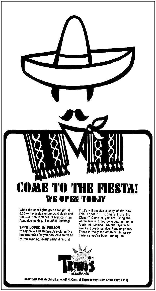
This 1969 ad for the “casual dining” Tex-Mex restaurant opened by singer Trini Lopez on Mockingbird Lane (across from the old Dr Pepper plant and a couple of doors down from Roscoe White’s Corral) has been added to “Trini Lopez: Little Mexico’s Greatest Export.”
*
And, lastly, it’s just a tiny addition, but I really like the logo featuring a football helmet; I’ve added it to the post about the Dallas company behind the development of the athletic face mask, “The Marietta Mask.”
Above, the Central Fire Station at Main and Harwood, photographed by Clifton Church and printed in the Dallas Fire Department Annual, 1901. Photos of the other stations — as well as a link to the scanned publication — can be found in the Flashback Dallas post “Dallas Fire Stations — 1901.”
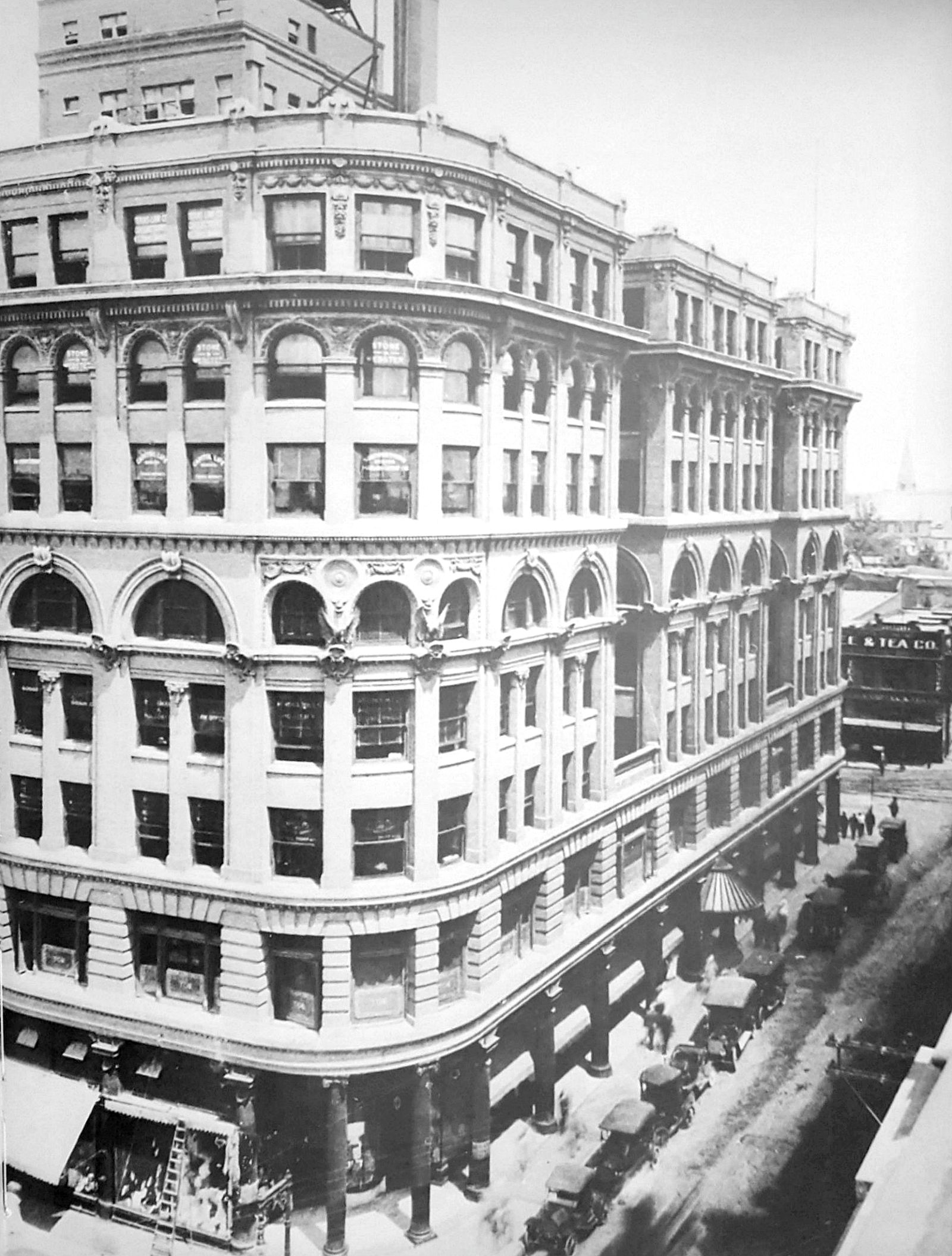
Another photo of the always impressive Wilson Building, this one showing the U. S. Coffee & Tea Co. (at the northwest corner of Elm and Ervay) in the background.
***
Sources & Notes
Photo from Dallas, An Illustrated History by Darwin Payne (Woodland Hills, CA: Windsor Publications, 1982; Sponsored by Dallas Historic Preservation League); original photo source is the Texas/Dallas History and Archives Division of the Dallas Public Library.
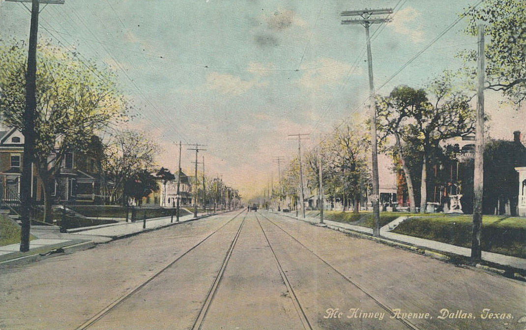
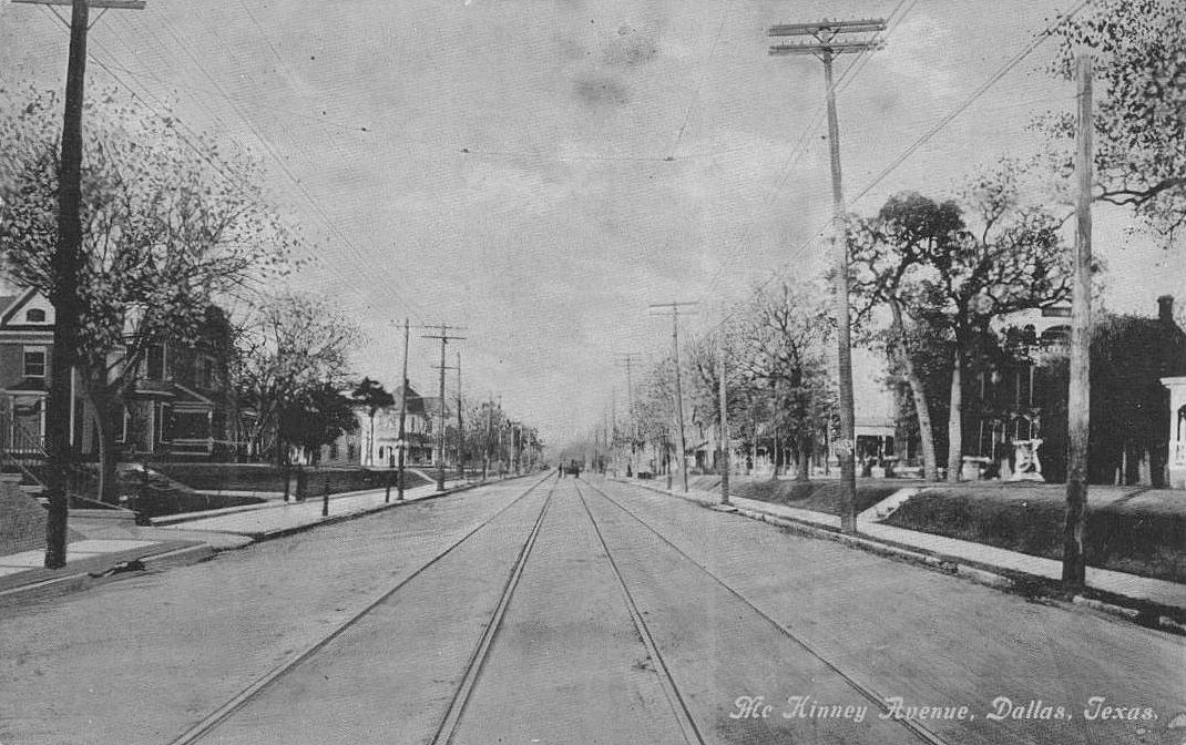
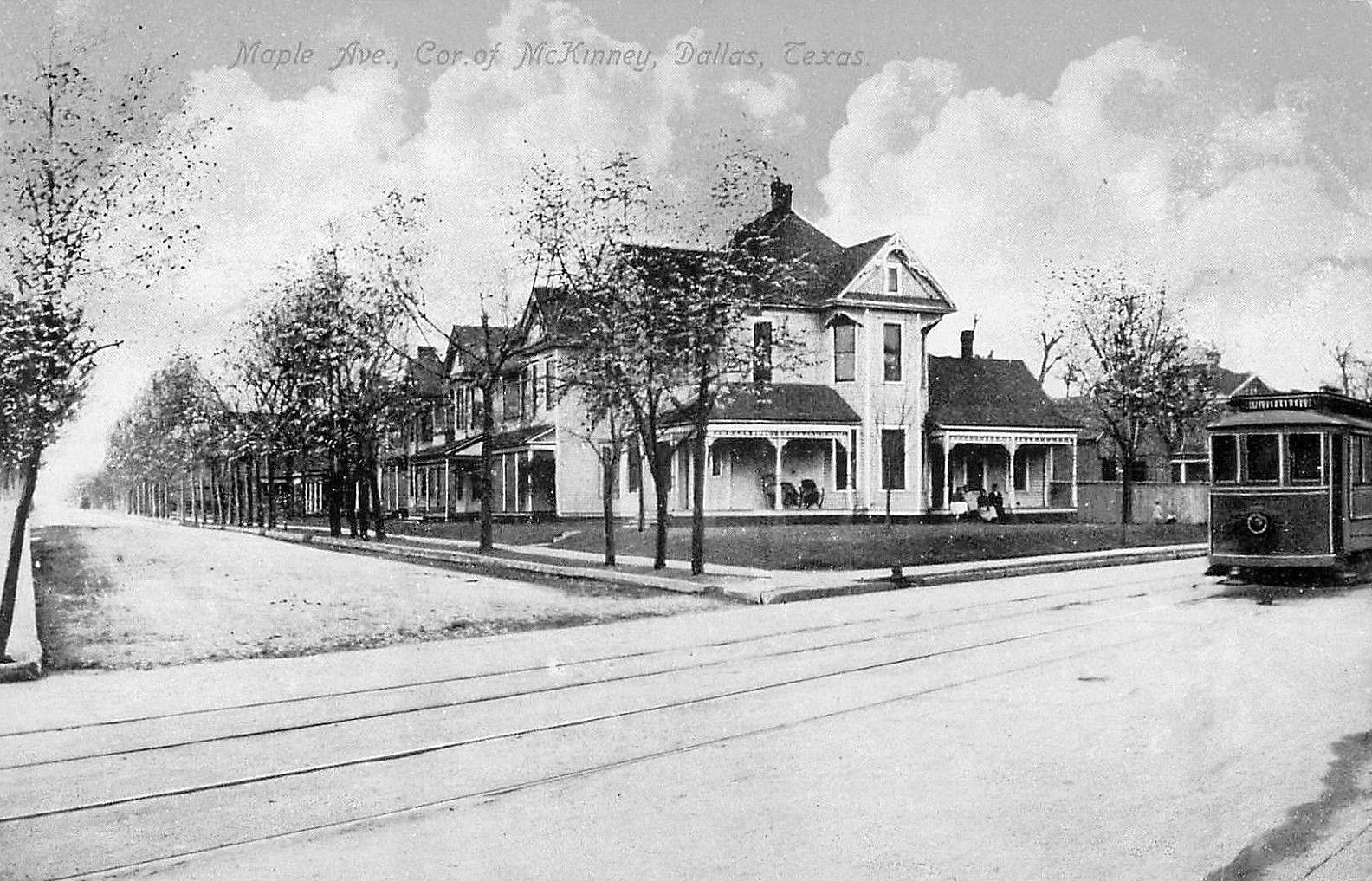
McKinney Ave., large houses, streetcar tracks… (click for larger image)
by Paula Bosse
Just a quick post of two picture postcards of McKinney Avenue (the images drained of their added color give a more realistic idea of the original photographs). These views are unrecognizable in today’s Uptown.
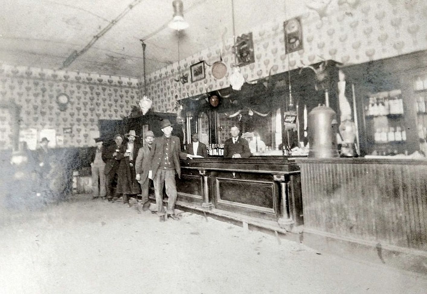
“Fritts & Dagnal,” Deep Ellum saloon… (photo: Brent Burton)
by Paula Bosse
Reader Brent Burton commented on one of my tweets on Twitter to say that he had an old photo showing his great-great-grandfather standing in a saloon he had owned in Dallas around the turn-of-the-century and wanted to know how he might access old Dallas directories in order to try to determine where the bar had been. I told him that online scans of city directories are available for free from the Dallas Public Library and the Portal to Texas History (more on this is in my post “How to Access Historical Dallas City Directories Online”). I also offered to see what I could find out.
The photo is the one above (click it to see a larger image). All he knew was that it was taken in a bar owned by his great-great-grandfather Jefferson Davis Dagnall (whose last name is most often spelled “Dagnal” in various documents such as census records, directories, and his death certificate, so I will refer to him with this spelling) and that the photo was taken in the late 1800s or early 1900s. I figured it would be pretty easy to find the info because his name was so uncommon, but that was complicated by the fact that his name was spelled and misspelled many different ways — I think I came across five or six permutations. It took a long time to figure out where that photo was most likely taken — mainly by going through census records and looking at all the city directories — year by year — to pin down where he was working each year. And he got around — he lived at a new address almost every year, and changed jobs almost as frequently.
Jefferson Davis Dagnal was born in 1861, probably in Fort Bend, Texas. His father, a South Carolina native, appears to have died fighting in the Civil War; Jeff (…I call him Jeff…) was 3 years old when his father died. By 1880 he was a teenager, working on a Dallas-area farm. In 1883, Jeff was working as a blacksmith. According to city directories, he held the following jobs: store clerk, laborer, streetcar driver, house-mover, electrician, and bartender.
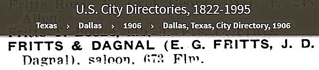
1905 was the year he seems to have settled into bartending, a job he held in various establishments in Deep Ellum for a decade, until his death in 1915. He appears to have owned (or co-owned) only one of these bars: Fritts & Dagnal. It seems the venture with partner E. G. Fritts was short-lived: its only listing is in the 1906 directory — by 1907 Jeff had moved on, tending bar elsewhere.
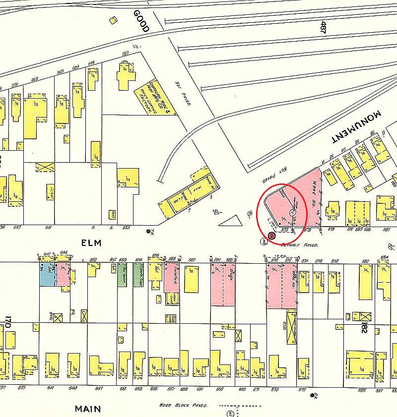
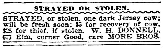
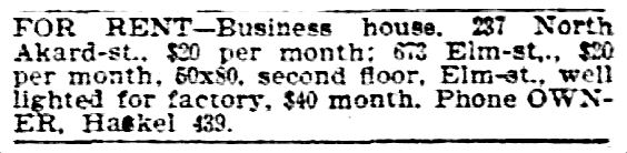
The saloon was listed in the 1906 city directory as being at 673 Elm — that address was changed in 1911 and became 2603 ½ Elm. This was in Deep Ellum, at the northeast corner of Elm and Good (possibly on the second floor). Below is a 1905 Sanborn map showing the location (the full map is here).
1905 Sanborn map, detail
The lot that building stood on at Elm and what is now Good-Latimer is empty, but a current-ish look at the location, from Google Street View, can be seen here (I am attempting to post a view from 2015, before all the construction work was going on near the Elm and Good-Latimer intersection — but just move up or down Elm a bit on Google and you’ll see construction images take over).
Below, a couple of ads from around the time Jeff Dagnal and E. G. Fritts decided to start up their short-lived saloon at 673 Elm: the first ad shows that it was not unusual in 1905 for large livestock to be kept in Deep Ellum (where they might even have been “rustled”), and the second ad shows that both the upstairs and downstairs spaces of the building at 673 Elm were available to rent:
Dallas Morning News, May 13, 1905
DMN, May 6, 1906
(According to the Inflation Calculator, those 1906 rents of $20 and $40 would be about $550 and $1,100 in today’s money.)
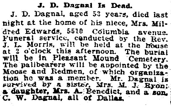
Jefferson Davis Dagnal died in Dallas on Feb. 25, 1915. His death certificate — with information provided by his daughter, Cora — listed his occupation as “blacksmith,” even though he had been a bartender (and, briefly, a saloon owner) for at least the last ten years of his life.
DMN, Feb. 26, 1915
*
One interesting thing about Mr. Dagnal, was his relationship with his wife Alice, the mother of his second child, Clarence, who was born in 1893. Alice and Jeff appear to have hit a rough patch in their marriage pretty early on. In the 1900 census, they were living in different cities, and each claimed to be widowed. I don’t know if they ever officially divorced (or even if they officially married), but I suppose it was easier in that era to claim a spouse had died rather than admit the shame of divorce or abandonment. By 1903 both were living in Dallas — at the same address. But by 1904 they were living apart, and Alice was, again, claiming to be a widow — even though an alive-and-kicking Jeff was listed in the directory right under her name!
1904 Dallas directory
I have come across this phenomenon so frequently that I now question every “widow” or “widowed” claim I come across. Information from the U. S. Census (where people give false ages and incorrect marital status ALL THE TIME) should be taken with a grain of salt!
***
Sources & Notes
Photo of Jefferson Dagnal’s saloon was shared with me by Dagnal’s great-great-grandson, Brent Burton and is used here with his permission. Jeff is probably in the photo — in 1906 he would have been 45 years old. Thank you for the great photo, Brent!
Thursday night I attended a very entertaining Dallas Historical Society presentation at the Hall of State in Fair Park: “An Evening With Jim Parsons: Lost Fair Park,” in which the author of Fair Park Deco and DFW Deco talked about many of the buildings constructed for the Texas Centennial Exposition in 1936 which are no longer with us.
One of Jim’s asides was that there are very, very few color photos of the Centennial buildings and murals taken in 1936. If you’ve seen a Centennial view in color, it’s probably a colorized postcard. Kodachrome film was introduced in 1935 and was, sadly, not in wide use by visitors to Fair Park in 1936 (or by the Centennial organization).
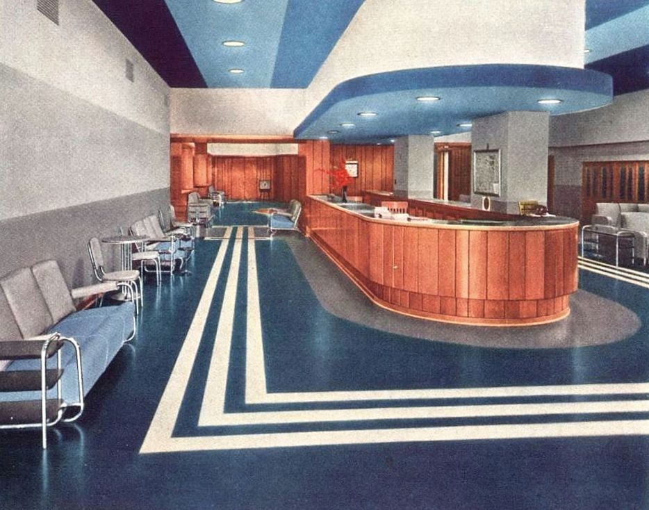
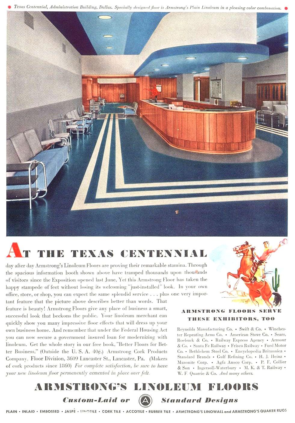
When he said that, though, I remembered an ad I had come across that I thought was pretty cool, simply because it shows the interior of one of the Centennial buildings when it was brand new (…well, it was sort of new — more on that below). The ad is for Armstrong Linoleum and it features a color photo showing one of their custom linoleum floors installed in the Centennial Administration Building, an interior I’d never seen. And it’s in color! (Check out the furniture and the recessed lighting!) Here’s the full ad, which appeared in national magazines in 1936 (click for larger image).
1936 ad
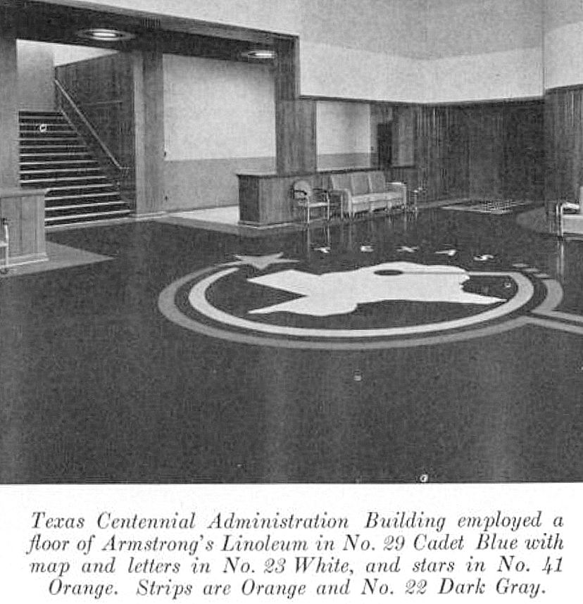
And — hallelujah — I found another photo of the interior — also from the helpful Armstrong people (I don’t know if they had the concession to outfit all the Centennial buildings, but, if so, I’d love to see all of their designs). Unfortunately this one is not in color, but it shows a fantastic Texas-centric custom design, laid down in fabulous linoleum.
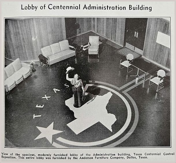
And another one:
Southwest Business, June 1936
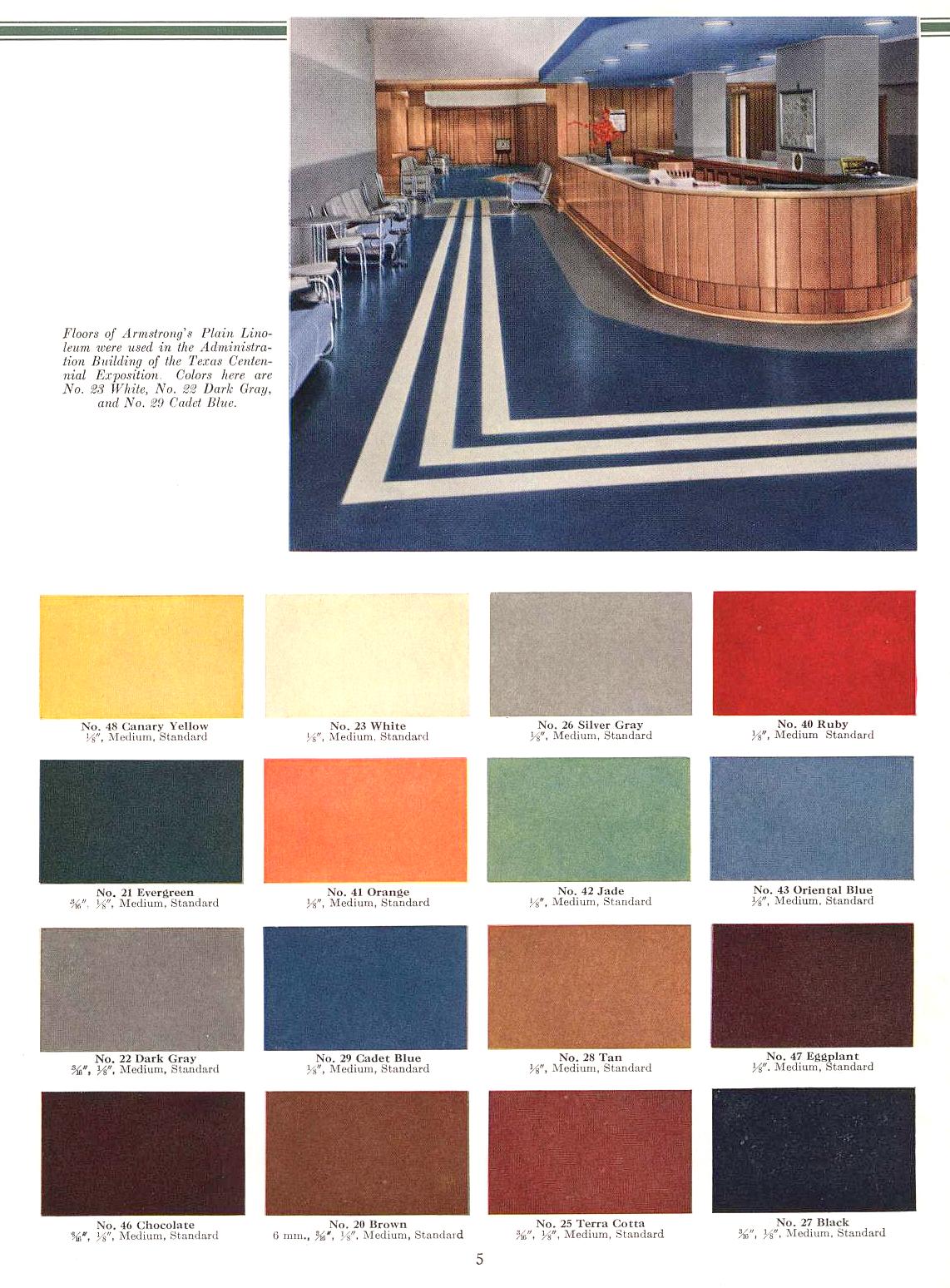
Imagine that floor in Cadet Blue, White, Orange, and Dark Gray. This is from a trade publication called Armstrong’s Floors and Walls for Homes and Public Buildings, published around 1950 (and fully scanned here). A cropped version of the photo of the top is also included here (that floor, by the way, is in White, Dark Gray, and Cadet Blue), with handy swatches (which, reproduced below, lose some accuracy in color).
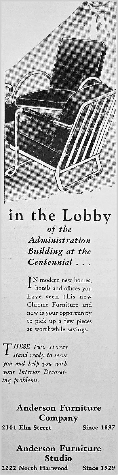
And just because I found an ad for those cool chairs:
Southwest Business, Oct. 1936
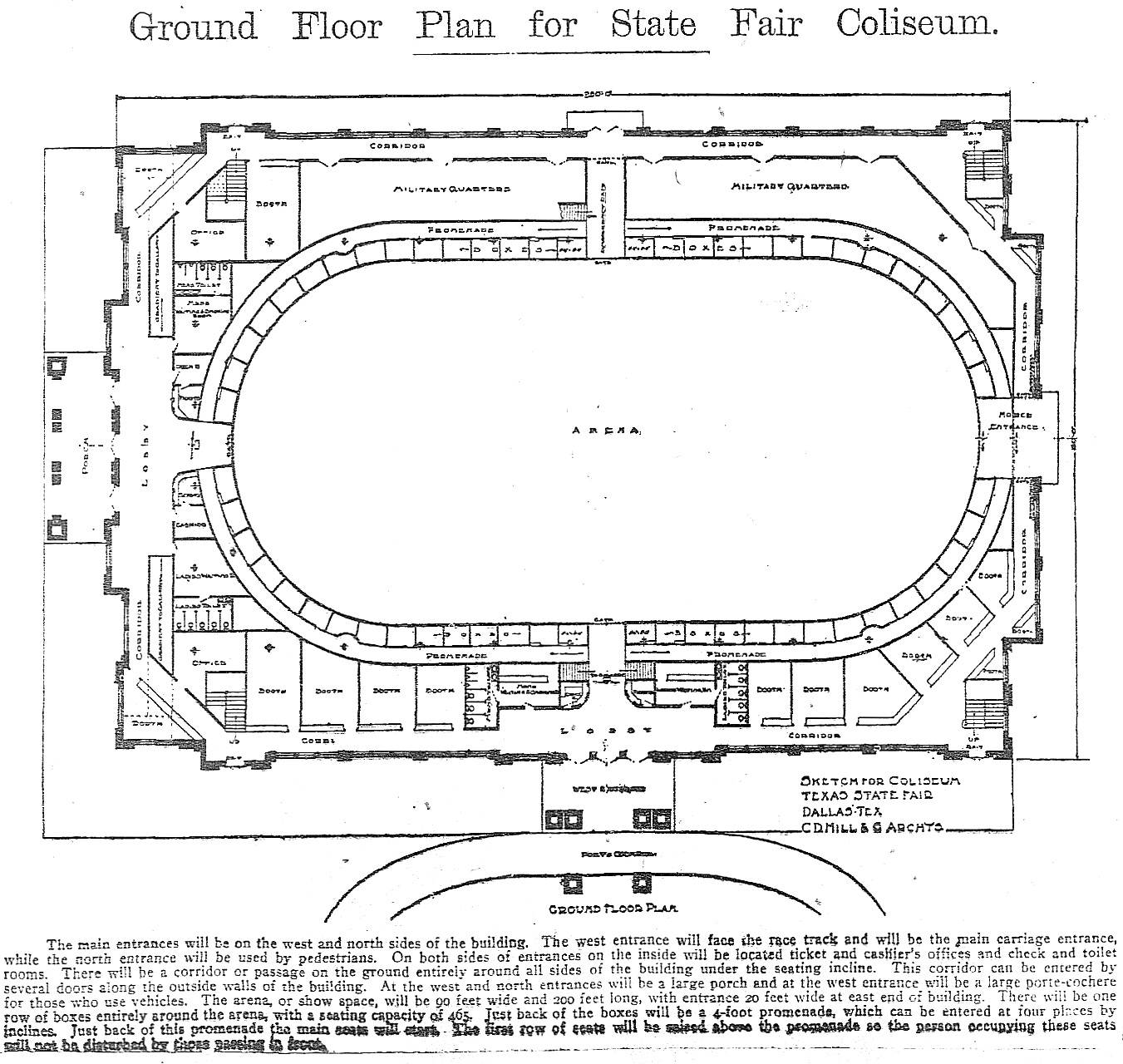
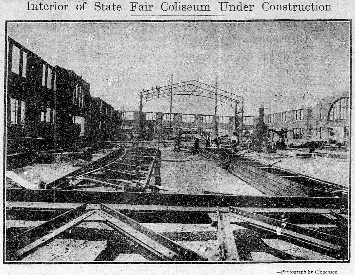
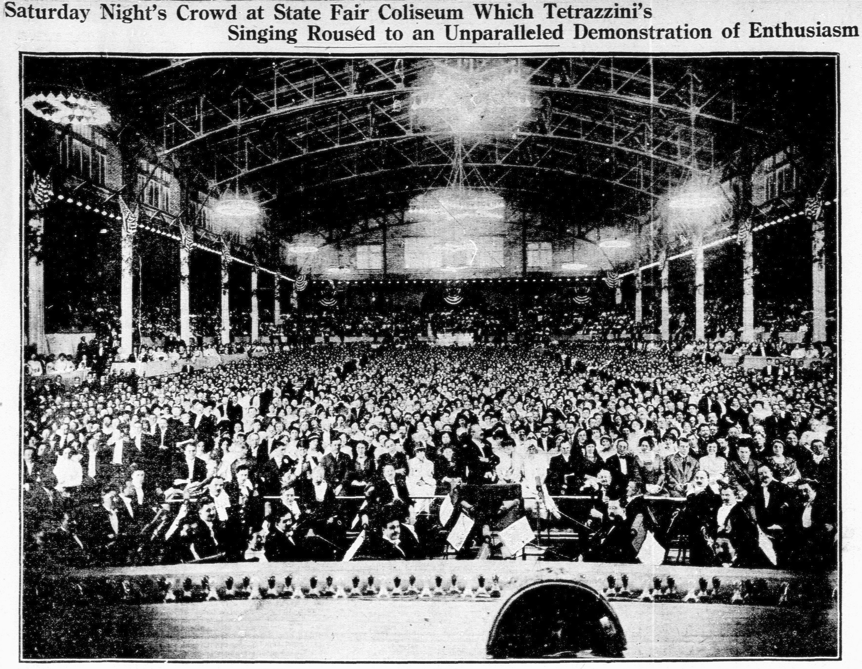
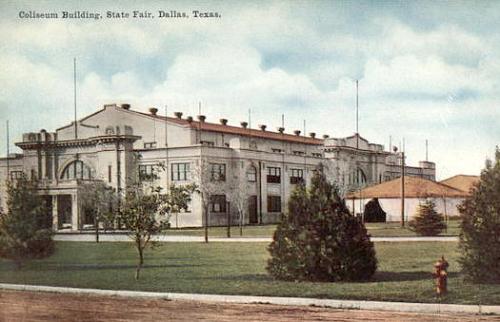
The Centennial Administration Building — which housed the hundreds of office workers and executives behind the running of the Texas Centennial Exposition — was actually the very first Centennial building completed (at the end of December 1935). Most of the Centennial buildings were newly built in 1936, but the Administration Building was actually an old building given a new stucco façade and completely remodeled — it even acquired a second floor inside the huge structure. This building was originally known as the State Fair Coliseum, built in 1910, designed by architect C. D. Hill (who designed many buildings in Dallas, including the still-standing Municipal Building downtown (built in 1914) and the Melrose Hotel (1924).
Dallas Morning News, June 20, 1909
DMN, May 7, 1910
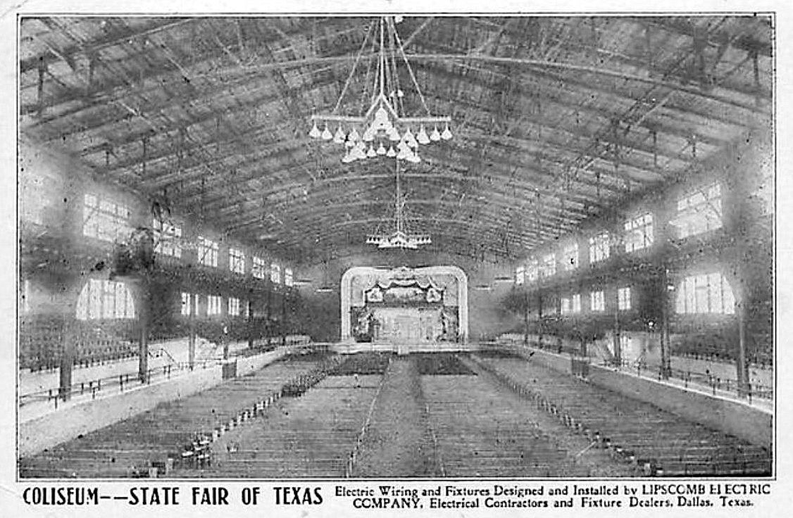
It was BIG. It had a seating capacity of 7,500.
DMN, March 4, 1913
This was the first building you’d see as you entered Fair Park, as it was right inside the front entrance on Parry Avenue (after you entered, the building would be on your left).
It was the city’s first official municipal auditorium, and it hosted everything from livestock shows, conventions, large civic gatherings, and the occasional opera.
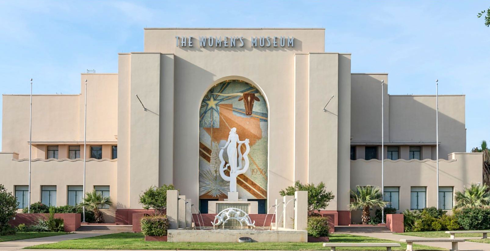
Fast-forward a few decades: in 2000 the building became the home of the Women’s Museum. The museum closed in 2011 and is now called the Women’s Building and is used for special events.
See a Wikimedia photo of this building in 2016 here — click it again (and again) to see it really big, and linger on the mural by Carlo Ciampaglia and the sculpture by Raoul Josset. See interior photos of the space in 2009 during its time as the Women’s Museum here and here. I’m not sure if the exposed brick and steel are from the original 1910 building, but I certainly hope so! And, lastly, exterior photos from 2009 showing the side of the building here, and here
***
Sources & Notes
This building can be seen on this aerial Google view, here. It is currently the Women’s Building, and it is available for special events — more about this building from the Friends of Fair Park, here.
Black-and-white postcard showing the interior of the Coliseum is from Flickr.
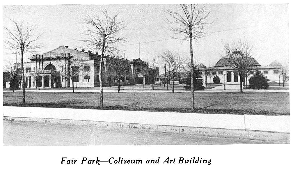
Black-and-white photo “Coliseum and Art Building” is from Report for the Year 1914-1915 of the Park Board of the City of Dallas, With a Sketch of the Park System (Dallas: Park Board, 1915), which can be accessed as part of the Dallas Municipal Archives via the Portal to Texas History, here.
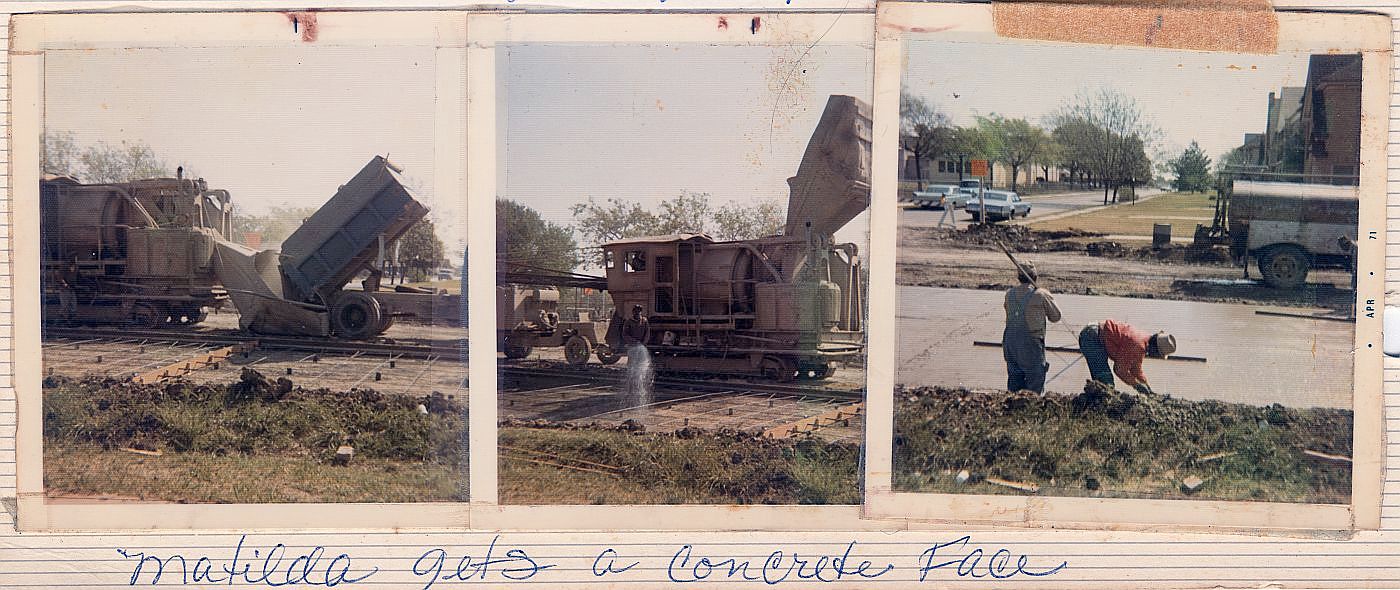
“Matilda gets a concrete face”… (click for larger image)
by Paula Bosse
A couple of days ago I wrote about the history of Matilda Street in regard to its role as a railway for the Sherman-Denison interurban and the Belmont streetcar line. I noted that I had childhood memories from the 1970s of Matilda being a dirt street — which seems hard to believe these days since it carries a fair amount of traffic and is generally a quicker drive than Greenville Avenue, one block west.
In response, one of the many Milazzo siblings (whom I remember not as individuals but as one large flock of children who regularly accompanied their parents to visit my father’s bookstore in the 1970s and ’80s) sent me some photos from a family album showing, yes, Matilda Street being paved! They lived in the 5700 block of Goodwin, and the photos were taken in 1971, from their yard, looking east across Matilda.
The streetcar tracks were abandoned in 1955 but were not removed — it took a full sixteen years for them to be paved over! Before that? Dirt street. If you look closely at the Google Street View capture from Oct. 2017, you can see the old rails peeking through.
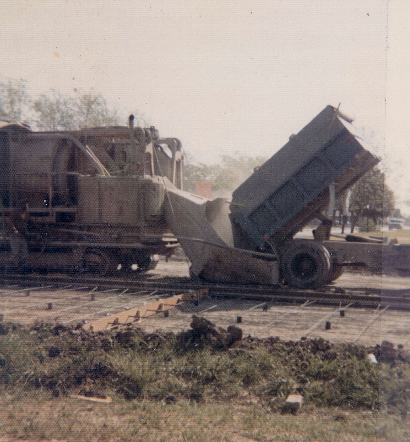
Below are three photos from the Milazzo’s family album showing the Matilda “street improvements.” The construction vehicle seen in the first two photos is pretty weird-looking — like a cross between a locomotive and a tank. In fact, at first I thought the thing was actually running on the rails it was working to pave over, until I saw that what I had thought were train wheels look more like tank treads. Whatever it is, it doesn’t look like something you’d expect to see on a residential street in the 1970s. In the third photo, you can see part of Robert E. Lee Elementary School at the left. (All photos are larger when clicked.)
Thank you, Milazzo family!
***
Sources & Notes
Photos from the collection of the Milazzo family, used with permission. The third photo shows a date-stamp of April, 1971.
The related Flashback Dallas post “Ghost Rails of the Belmont Streetcar Line” is here.
Matilda & Richmond, April, 2018… (photo: Dan Parr)
by Paula Bosse
I grew up on Ellsworth, between Greenville Avenue and Matilda — just south of Mockingbird, just north of the M Streets. When I was a child, Matilda was only partially paved — in my neighborhood, maybe only from Mockingbird down to Kenwood? Otherwise, it was a dirt street (!) — and this was in the ’70s! Right around Kenwood was a weird mound which might not have looked like much to an adult, but to a child it was pretty strange. I can’t remember if the rails were visible — I’m pretty sure they were.
That line was the Belmont Line, which ended (began?) at Mockingbird (I think there was a later extension of sorts, but I think Mockingbird was the end of the line for streetcar passengers). As a kid, I knew that Matilda had been a long-gone streetcar line, but never having seen a streetcar outside of a movie, I couldn’t really imagine what it must have been like to have streetcars (and an interurban! — more on that below) moving up and down a street which was less than a block from my house.
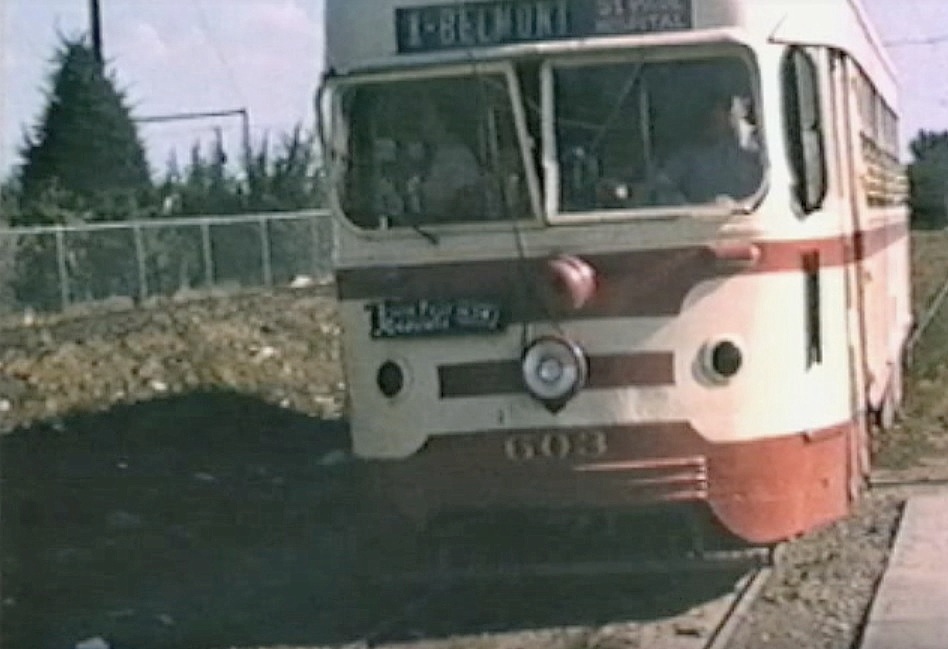
A few years ago I stumbled across the YouTube video below and was surprised to see actual footage of that streetcar rolling up Matilda. The first five minutes of the video contains 16mm footage (both black-and-white and color) shot around Dallas in 1953 and 1954 by Gene Schmidt. It’s GREAT! You’ll see streetcars-galore moving past all sorts of familiar and vaguely familiar sights around the city, from Oak Cliff to downtown to way out to Mockingbird and Matilda. It ends with the Belmont-Seventh car (car 603) pulling to the end of the line — the view is looking south down an unpaved Matilda Street from Mockingbird, with a glimpse of the Stonewall Jackson playing field at the left, on the other side of the fence. (The Matilda footage begins at 4:17.)
*
Matilda, south from Mockingbird, ca. 1954 (Gene Schmidt)
Above, a screen capture from the video showing Matilda looking south from just south of Mockingbird. Stonewall Jackson Elementary School is at the left. Today the view looks like this.
*
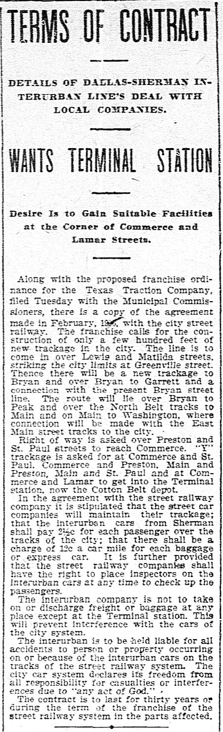
Before the streetcar arrived, Matilda was the artery that led the Texas Traction Company’s Sherman/Denison interurban into Dallas. This electric interurban service from the north, which closely followed the H&TC railroad line, arrived in Dallas in 1908, back when the official entry-point into the Dallas city limits was just off Matilda, near Greenville Avenue and Bryan Street.
DMN, Jan. 16, 1908 (click to read)
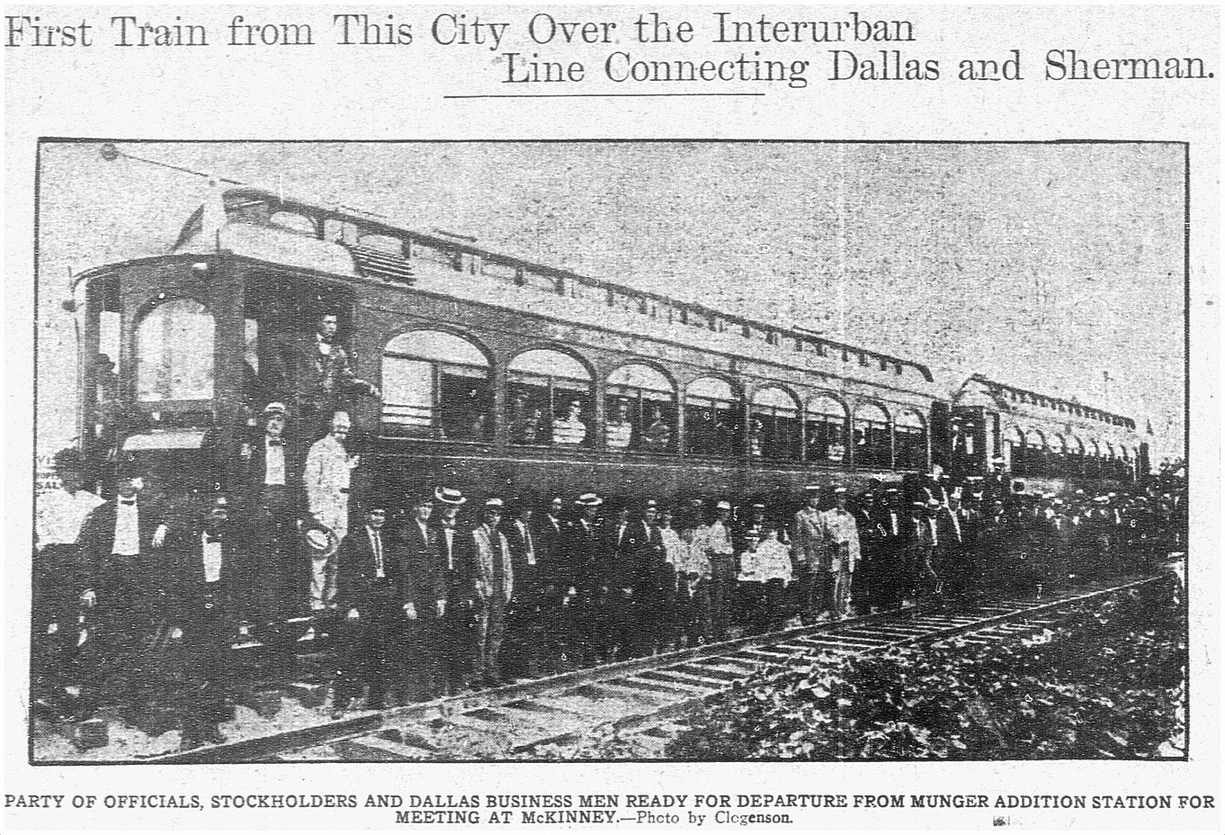
The interurban route connecting Sherman/Denison with Dallas opened on July 1, 1908 and lasted for 40 years, until its final run on December 31, 1948. (Read the Dallas Morning News article on the 1908 inaugural trip for big-wigs, “Many Make Trip Over Interurban,” July 1, 1908, here. Below is the accompanying photo. Image that running up and down Matilda — and, later, along other streets in Dallas — several times a day!)
DMN, July 1, 1908
Dallas’ ever-increasing population began to move northward and eastward, necessitating public transportation which would connect these developing areas with the rest of the city. One of the early “suburban” lines was the Belmont Line, which branched off the Bryan Street line and served the Belmont Addition and beyond; it opened in 1913, but these early days appear to have been more of a private “dinky” service (see SMU’s dinky car on the beyond-the-city-limits tracks at Hillcrest and McFarlin, here). The Belmont line — as well as the Vickery Place and Mount Auburn lines — became part of the city’s official streetcar system in 1922.
Before the dinky service, riders were able to get on and off the large interurban cars at stops between Mockingbird and the area around Bryan and Greenville Ave. Even though interurbans and streetcars were able to travel on the same rails, it took years for dedicated streetcar tracks to be laid along Matilda.
This detail of a real estate ad shows that the Belmont line had reached at least as far as Richmond by 1914 (I felt I had to include this because the finger is pointing at the exact location of the exposed rails in the photo at the top!):
May, 1914 (detail from Lakewood Heights real estate ad — see full ad here)
By 1922 the Belmont line had extended north to Velasco; by 1925 it had gotten to McCommas; by 1936 it had made it up to Penrose; and by 1939 it had finally reached Mockingbird (in time for the opening that year of Stonewall Jackson Elementary School, located at Mockingbird and Matilda).
Dallas streetcars began to be phased out in 1955, and the Belmont line was one of the first to go — its last run was March 6, 1955: “The Belmont-Seventh streetcar line will go out of existence Sunday to be replaced by service with new Diesel buses” (Dallas Morning News, March 6, 1955). The new bus route in the Lower Greenville area would, for the most part, be along Greenville Avenue, one block west of unpaved Matilda Street.
In March, 1955, it was reported that the abandoned Belmont-Seventh streetcar tracks were deeded to the city by the Dallas Railway and Terminal Co., with the understanding that they would eventually be paved over. The tracks were on Matilda, Bryan, Cantegral, Live Oak, St. Paul, King’s Highway, Edgefield, Seventh, Bishop, and Colorado. In April, 1956, it was reported that the City Council had approved the sale of the streetcar viaduct over the Trinity River and the Matilda street right-of-way.
But what about that paving of Matilda? Mrs. K. E. Slaughter had thoughts on the matter in a letter-to-the editor in April, 1955:
Since removal of the Belmont streetcar line in part — Matilda and Bryan streets — would it not be advantageous to develop this section into an important use to the heavy automobile traffic? Matilda now is no more than useless tracks built up between a cow path. (DMN, April 7, 1955)
“Cow path” — ha!
Another annoyed News reader wrote in 1963 — eight years after the tracks had been abandoned — about the useless unpaved thoroughfare:
The abandoned almost-private right of ways, such as Matilda, nearly two miles south from Mockingbird, received by the city in a deal to permit an all-bus operation, have not yet been paved or otherwise improved. (DMN, Oct. 21, 1963)
I’m not sure when that paving finally happened — early ’70s? — I think it must have been done in stages. I don’t remember a time when the stretch between Mockingbird and Kenwood wasn’t paved, but I do remember Matilda being a dirt road south of Kenwood. I don’t have a good recollection of the year, but kids remember all sorts of weird things, and those mysterious mounds were pretty memorable. (UPDATE: See photos of Matilda being paved at Goodwin in 1971 here.) I wish I’d known what an interurban was when I was a child. That would have made my neighborhood seem a whole lot more interesting! Heck, it used to the Gateway to Sherman!
I’ve long despaired of having missed the streetcar age. But it’s nice to know that one ran so close to the house I grew up in.
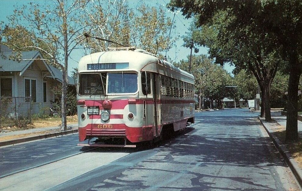
End of the line, ca. 1954… (Gene Schmidt)
***
Sources & Notes
Top photo taken by Dan Parr on April 15, 2018; it was originally posted to the Facebook group Dallas History Guild and is used here with permission. (Thanks, Dan!) The photo was taken at Matilda and Richmond, looking south on Matilda. See it on Google Street View, here. (Roadwork along Matilda is awful at the moment, but much-needed. Apparently it is being reduced to three lanes for automobiles with two bike lanes being added — read about it in the Lakewood Advocate, here.)
YouTube video shot by Gene Schmidt in 1953 and 1954; the direct link is here.
Another interesting video on YouTube was made by the City of Allen and contains period footage of the interurban that served North Texas. It’s a breezy 6-and-a-half minutes, and it includes some cool shots of Dallas.
If you want to see a whole bunch of North Texas interurban photos, check out this great 83-page PDF compiled by DART, “History of the Interurban Railway System and Monroe Shops,” here.
Speaking of DART, they posted a cool 1925 map of streetcar and interurban lines, here — click the map to see a larger image. (In 1925, the Belmont line ended on Matilda at McCommas).
ALSO extremely cool is a Google map showing Dallas’ Historical Streetcar (and Interurban) Lines laid over a present-day Google map, here. Zoom in and out. Very useful!
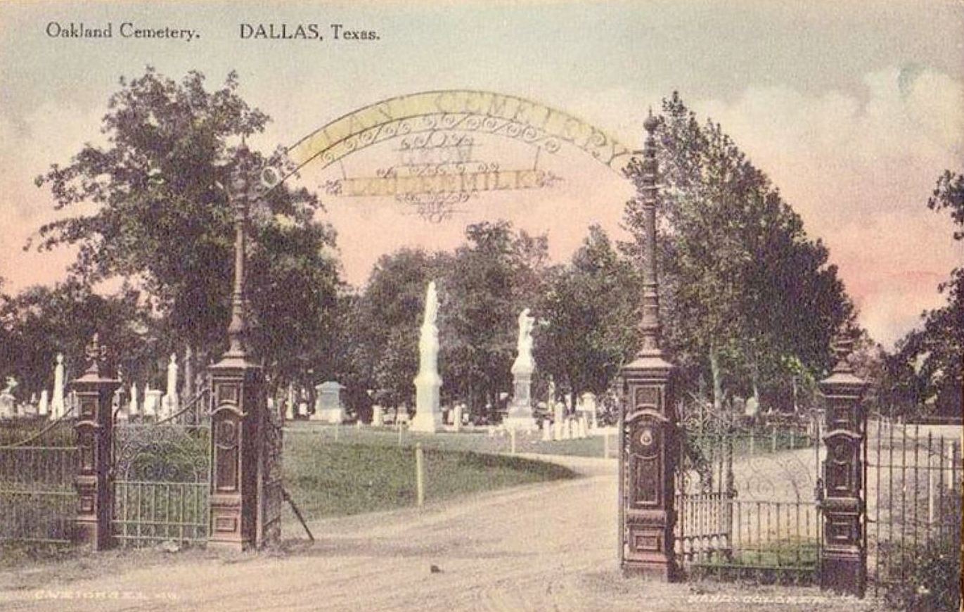
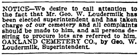
A beautiful postcard showing the gates of Oakland Cemetery emblazoned with the name of one of Dallas’ most prominent funeral directors, George W. Loudermilk.
Dallas Morning News, June 1, 1902
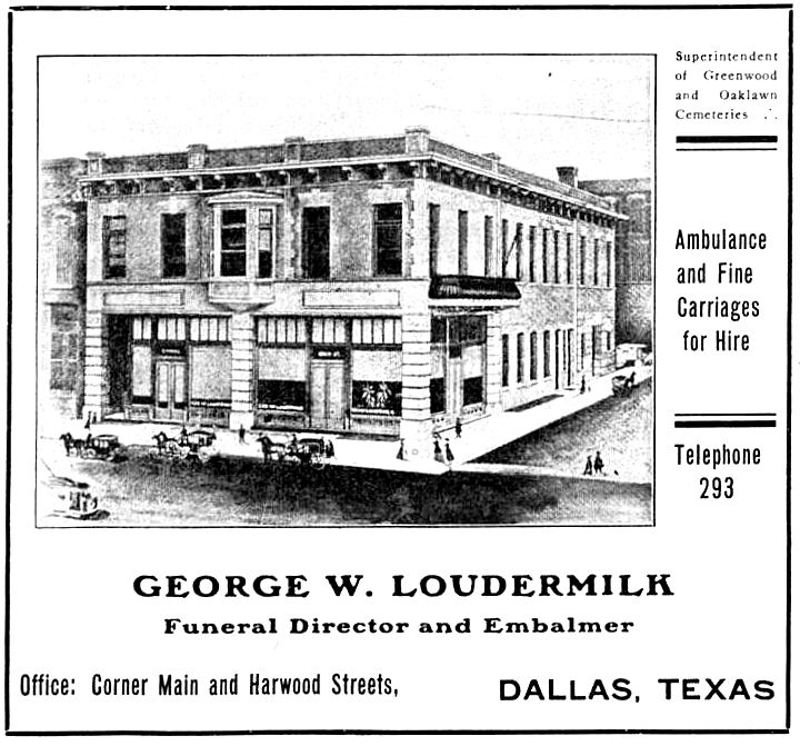
1906 ad
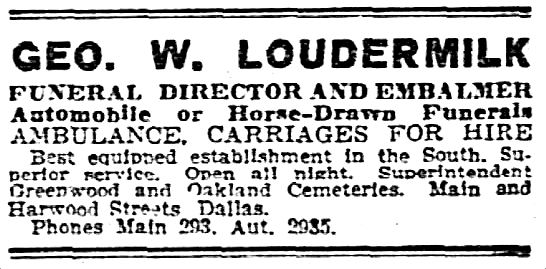
DMN, July 19, 1912
***
Sources & Notes
More on historic Oakland Cemetery, in South Dallas: